
Minor Faults at Banshee Reeks Nature Preserve
This post explores some more around Bull Run Fault (BRF), following up on the previous post. The original motivation was to see if Goose Creek Reservoir was low like Beaverdam Creek Reservoir, but that proved impossible because there is no access. It is surrounded by private land posted no trespassing. So instead, we went to a local nature preserve to see what we could find. We had no problem finding interesting geology to explore.

Plate 1. Geologic map of the study area, showing several features from the last post. This post focuses on Area A (black square) and Area B (purple rectangle). Jurassic and Triassic sedimentary rocks (shown in various green hues) are cut by Jurassic diabase (pink hues). The diabase cuts across the older rocks, forming sills and dikes, which this map shows well; the irregularity of the contacts between the igneous and sedimentary rocks is due to this cross-cutting. In summary: Proterozoic rocks (left side of BRF) were deposited and/or emplaced during collision of proto-North America and proto-Europe about 600 my ago; the resulting mountain chain then eroded and deposited sedimentary rocks; erosion removed this thick section of rock over the following 300 my; the earth’s crust began to stretch and sedimentary rocks were deposited in the resulting low areas as the resulting supercontinent (called Pangea) split apart; the crust finally broke and BRF was a major fracture; magma rising from the mantle filled fractures and weak areas to create extensive diabase sheets and dikes; these sediments/igneous rocks were buried under thousands of feet of sediment until the crust rebounded isostatically, and another cycle of erosion began. This Wilson Cycle is recorded in the geologic map.

Plate 2. Exposure of Bull Run Siltstone from Area A in Plate 1, showing similar variability as at other locations. Silt and sand was deposited in intermontane basins as the crust pulled apart about 200 my ago. This series of sand, silt, and mudstone is a couple of miles thick and varies within the right side of Plate 1; this variability resulted from river deltas switching about during the millions of years represented by these rocks.
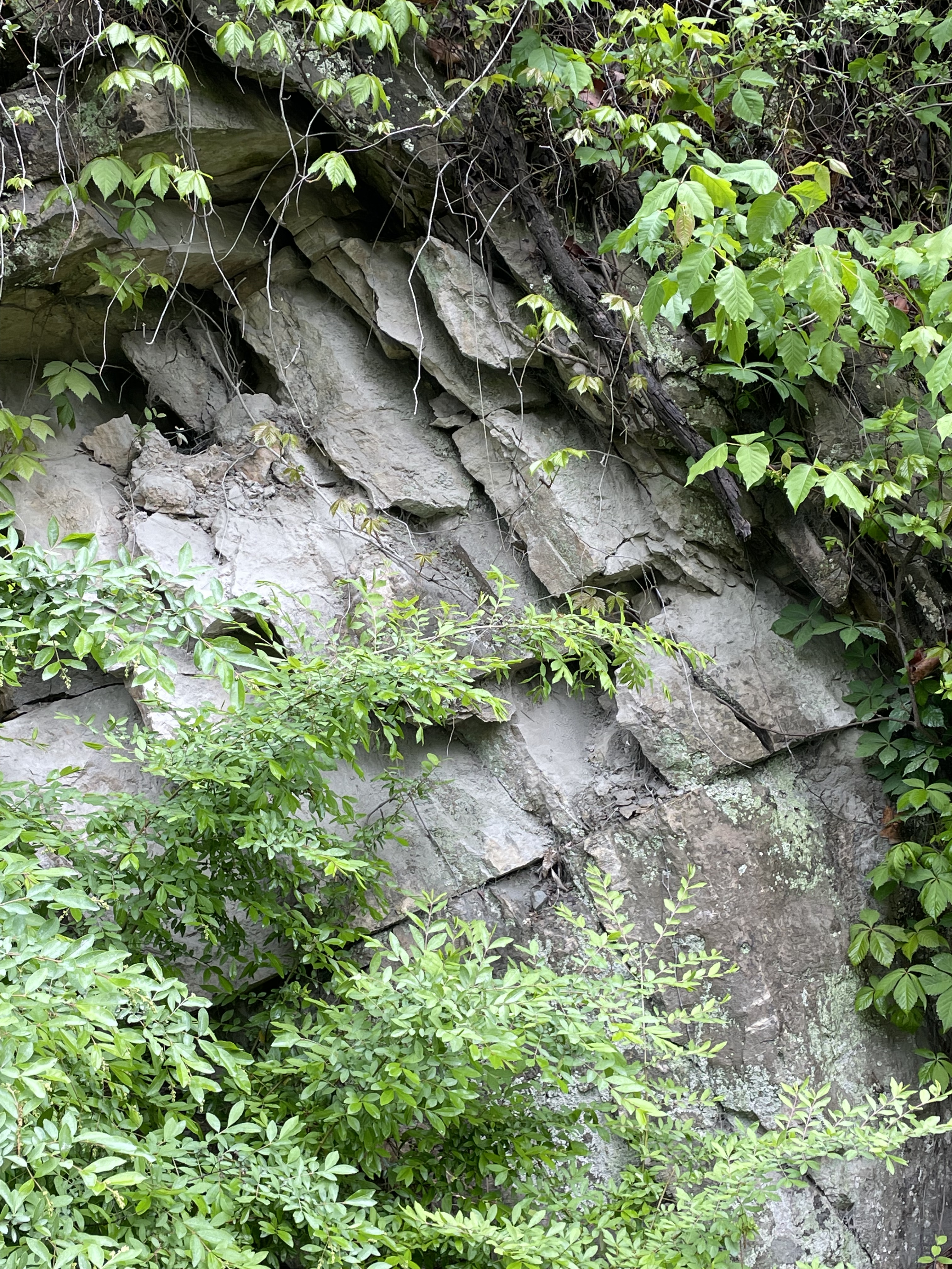
Plate 3. Close-up of rocks from Plate 3, showing powdery material that indicates intense crushing during faulting. In fact, this location is very near a fault (labeled F1 in Plate 2). The fault was not visible along the road, probably because the rocks were highly fractured and weathered faster than those further removed. Note the near-vertical fractures, which are perpendicular to the bedding planes seen in Plate 2.

Plate 4. Geologic map of Area B (see Plate 1). There are two faults running approximated east-to-west in the map. The more-northern one (unlabeled) can be seen to displace the Jurassic conglomerate to the east (pinkish area offset ESE of Oatlands Plantation). The southern fault (labeled F2) displaces this same rock within Banshee Reeks Nature Preserve.

Plate 5. Photo taken where fault F2 crosses a stream bed (see Plate 4). I used a question-mark to identify F2 because I didn’t go down to the stream and dig around to identify displaced sedimentary beds. From the trail we can seen that the sediment to the right of F2 is coarse whereas to the left is finer. At this location, the coarser sediment is Jurassic conglomerate, deposited as BRF began to uplift the plateau to the west (see Plate 1). Minor faults like this one and F1 (see Plate 1) released local stresses and are not necessarily oriented along the regional structural trend of 30 degrees east of north.
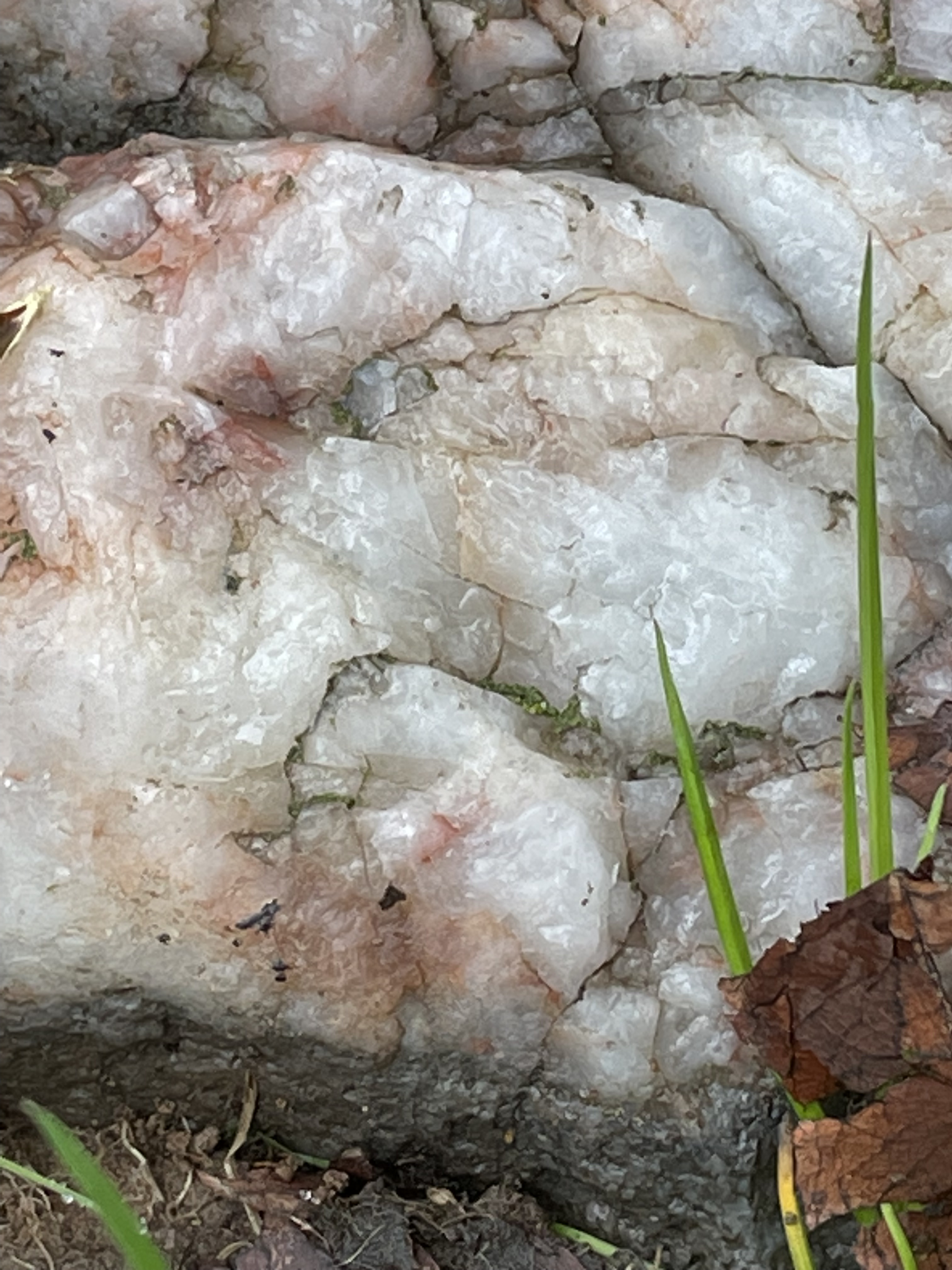
Plate 6. Close-up of a boulder (~1 foot across) of quartz lying on the ground within Area B. The sedimentary rocks do not contain quartz boulders, nor does the diabase that is present east of BRF. This sample must have been eroded from not far away, based on its size, as BRF raised the plateau to the west, and traveled down a long-gone stream, before lowering as the softer Bull Run Siltstone rocks eroded. It rode a geological elevator to its current elevation. Proterozoic granitoid rocks are common west of BRF and quartz is a common constituent of metasedimentary rocks, as we saw in a previous post.

Plate 7. Photo of a stone wall constructed from locally available boulders. The center piece is conglomerate (note the larger clasts in a fine matrix), probably the Jurassic conglomerate labeled in Plate 4. This image also shows pinkish rock (lower-right) that is probably derived from the Jurassic diabase, flaky stones from the Bull Run Siltstone, and a rounded cobble (center) of a fine-grained rock, which is probably diabase.
This hike, in combination with previous outings (Morven Park, Beaverdam Reservoir), allows us to apply Steno’s Laws to gain insight into the geological history of this region because we have a couple of additional clues: the conglomerate was deposited as BRF displaced older rocks thousands of feet vertically, but it was in-turn displaced by more faulting as the rocks adjusted to the major regional displacement. In other words, the geology of Loudoun County shows that the rifting of Pangea was an ongoing process that cycled through uplift, sedimentation, intrusion of igneous rocks, etcetera, for millions of years.

Trackbacks / Pingbacks