
Review of “El obsceno pájaro de la noche,” by José Donoso
This book was over my head. I think it is too difficult for someone who reads Spanish well. I found it on a web page that recommended books for intermediate Spanish students, which I admit I am not. But I wanted to be introduced to more writing styles. I sure got that. It took six months to finish this novel, but I can say that I have as good an understanding of it as anyone, except maybe someone with a large Spanish vocabulary who could have read it in a couple of days or weeks.
Okay, now for the book itself. First, the grammar and punctuation. There was none. Sentences sometimes lasted for pages, especially when the “Narrator” was sharing a stream of consciousness, paragraphs for many pages. There was no attempt to use proper punctuation. Commas were tossed around like paper boats in a hurricane. This was what made it so difficult to read for a beginner or even intermediate reader. Prepositional phrases were not identified with commas and Spanish is a little weak on conjunctions.
As with other Spanish authors and even translated books, pronouns were avoided at all costs. To make it worse, the author used the present subjunctive conjugation more than the present tense; the PS in Spanish is the same for first person and third person singular. Also for third person and second person plural. When the narrator is speaking in first person, describing what someone else is doing…you can see the potential difficulties.
I don’t think the story has a plot. Some chapters describe historical events in Chile’s history completely in the third person, and aren’t too difficult to follow. These scenes are less than a third of the book. Most of it is the first-person narrator jumping between perspectives, occupying every character’s mind at some point. It was an interesting style, which was taken too far because this head hopping occurred in mid-sentence as often as not. I read a lot of paragraphs (single sentences) several times to verify this. Bizarre is an understatement.
Several of the threads made sense. For example, the actions of two of the characters and their families’ histories is straightforward, as is some of the action at a run-down church that serves as a homeless shelter/orphanage. There is another thread (maybe multiple — it’s hard to say) based on the assistant of a central character (Jeronimo de Azcoitía), who appears to be stark, raving mad. Paranoid delusions abound and this guy talks to imaginary characters and is pursued by newspaper photos. There’s an entire chapter of such outrageous behavior that the story wanders into Monty Python territory. This floating narrator even becomes an infant, but they are predominantly a man who apparently had a nervous breakdown and fled from his employer (Azcoitía), seeking refuge in the church.
I don’t want to forget about the deformed child of Azcoitía and his wife, who was walled into a country estate and surrounded by naked deformed people. This was a major thread that ended without settling or explaining anything. It’s like the author lost interest. Strange. The relationship between this thread and another (involving a 15 year old girl who’s pregnant) was never explored and also dropped without notice.
Finally, the book just ended. The narrator spent the last five pages imagining being sewn into a sack (in the mind of the infant) and trying to escape, and failing. Nothing happened. The story just ends with an old woman who isn’t one of the central characters from the Church/homeless shelter.
The preface is written by another Chilean writer, who warns the reader that this book was written over a period of years (1962-1969) when the author had mental health issues. That would explain the coherent chapters and those that are in never-never land. To me, despite the lack of a plot, any explanations, or an ending, I kind of enjoyed reading this novel because it gives a lot of insight into what goes through the mind of someone who’s suffering from paranoid schizophrenia, or something like that. I couldn’t help getting the impression that the bizarre, stream of consciousness thread was a reflection of the author’s own suffering.
I was disturbed by the evocative images of depredation, created for no purpose but which the narrator couldn’t get out of their mind, whichever mind they were occupying at the time. Some of these will take years for me to forget.
This novel is available in an English translation. I don’t know how that would work because of all the untranslatable sentences and words. The English version can’t be more than an educated guess at what the author had in mind. (He didn’t translate it himself although he probably could have, having lived decades in the U.S.)
I suggest it for anyone who wants to see what it’s like to lose your mind.
We are all actors
We don’t get paid as much as Hollywood stars because we’re not very good at pretending to be someone we’re not. That’s the only difference. They simply have a talent for forgetting who they are, allowing them to step into someone else’s mind. It’s possible that actors have the best-developed Theory of Mind of anyone on the planet.
Being able to get inside someone else’s mind isn’t the same thing as understanding their situation. I’m digressing so I’ll get back to the point.
We are all actors. And like professional actors, we have some capacity for understanding another person’s plight, and like professionals, we treat the subjects of our curiosity as objects. Our attention lasts only a few seconds, or maybe minutes. The length of a scene. Our lives are a series of scenes, and cinema has simply found ways to reproduce the perceived reality we share in the discontinuous manner our brains are accustomed to.
The next time you watch a movie, consciously place yourself in the story, not as a viewer but as a participant. You have of course been doing this all your life; my point is to think about it, and maintain that sense of being in the action. You will find that it is reality.
This is the reason for the title of this post. We play roles, a well known fact, but the sociologists don’t dare go further. They can’t say what is obvious: Most of us shouldn’t waste our time thinking but just go with the flow, and play our roles.
It’s good to know your role. Just do it!
Unfortunately, I can’t do that…bummer; however, I can write these blogs that no one will read…
LOL.
The Least Common Denominator
Historians and sociologists avoid a taboo subject they can’t mention, or else their careers would evaporate. There’s a good reason for this tradition. It prevents every stupid idea from becoming widely accepted but guess what, that information dissemination model has failed. With so much disinformation accepted by so many people, it’s time to speak openly.
With so much history to examine, historians have plenty of examples of the rise and fall of nations and empires. The data show that people do stupid things, where stupid can be interpreted to mean self-destructive acts that were not the result of careful contemplation. Just take the…why bother giving examples. You can find plenty of examples. That is the interesting aspect of this problem, the reason for this post.
The least common denominator is “The least common denominator (LCD) is the smallest number that can be a common denominator for a set of fractions.”
When applied to groups of people, this concept has names like “The squeaky wheel” or the “Vocal minority.”
No matter what name is used, this group of people always wins, creating every form of government imaginable, from the monarchies of antiquity to liberal democracies. Scream loud and you will get your way, especially if you know guys with guns. There’s something about having weapons, the ability to kill other people at will, that causes the LCD (Least Common Denominator) crowd to get excited.
All societies are LCD based. Variations between global areas are nothing more than reflections of what the vocal and connected minority wants, whether its authoritarianism as in China and Russia, liberal democracy as seen in Western Europe and Australia, or anarchy as expressed in the United States. These choices and how they are instantiated are the legacy of millennia of cultural development.
In other words, there’s nothing we can do about it.
Bottom line:racism is the LCD; war is the LCD; paranoia is the LCD; fear and superstition are both LCDs; so get used to it and stop dreaming about a better world. It may come but only when the global LCD has been found and…
I don’t know what that will be…
The Adelaide Superbasin
The terminology and nomenclature used in geology change constantly, just like in every other discipline. Thus, what was originally a geoscyncline, became a rift complex, and is now a superbasin. I guess that being bigger is better than being complicated. Adelaide is in the Wild West of Australia. Because of the name change, this post is about the Adelaide Superbasin (Fig. 1).
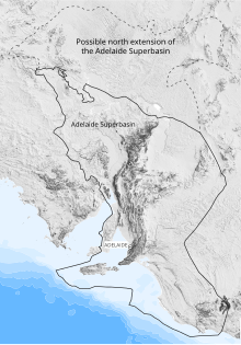
It isn’t possible to describe hundreds of stratigraphic formations in a blog post, so I’ll do as I always do and describe what I saw with my own eyes. I couldn’t find a geological map of South Australia, so I’ve compiled a schematic map of the the region (Fig. 2).

The Starting Point (Fig. 2) was reached after crossing the Murray River at Murray Bridge(Fig. 3), a view not unlike entering the Rio Grande Valley at Las Cruces.
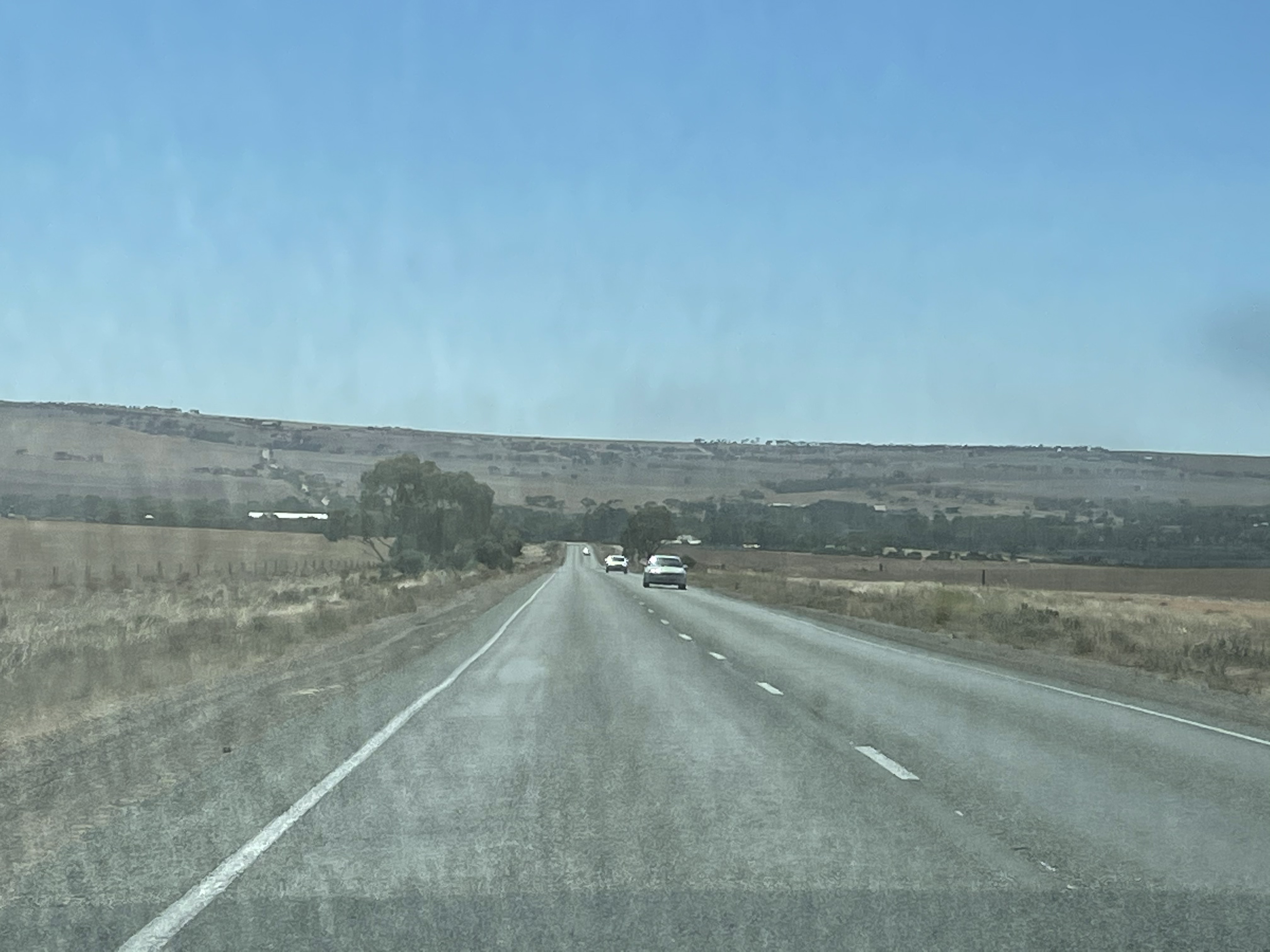
The Murray River was the lifeline for the agricultural regions of South Australia until the1940s, when rail and trucks finally became more profitable. The river remains a center of transportation and tourism (Fig. 4).

The Murray River is also a major source of water for the region. Large pipes followed the highway, leading in different directions, unimpeded by the Flinders Range (Fig. 5).

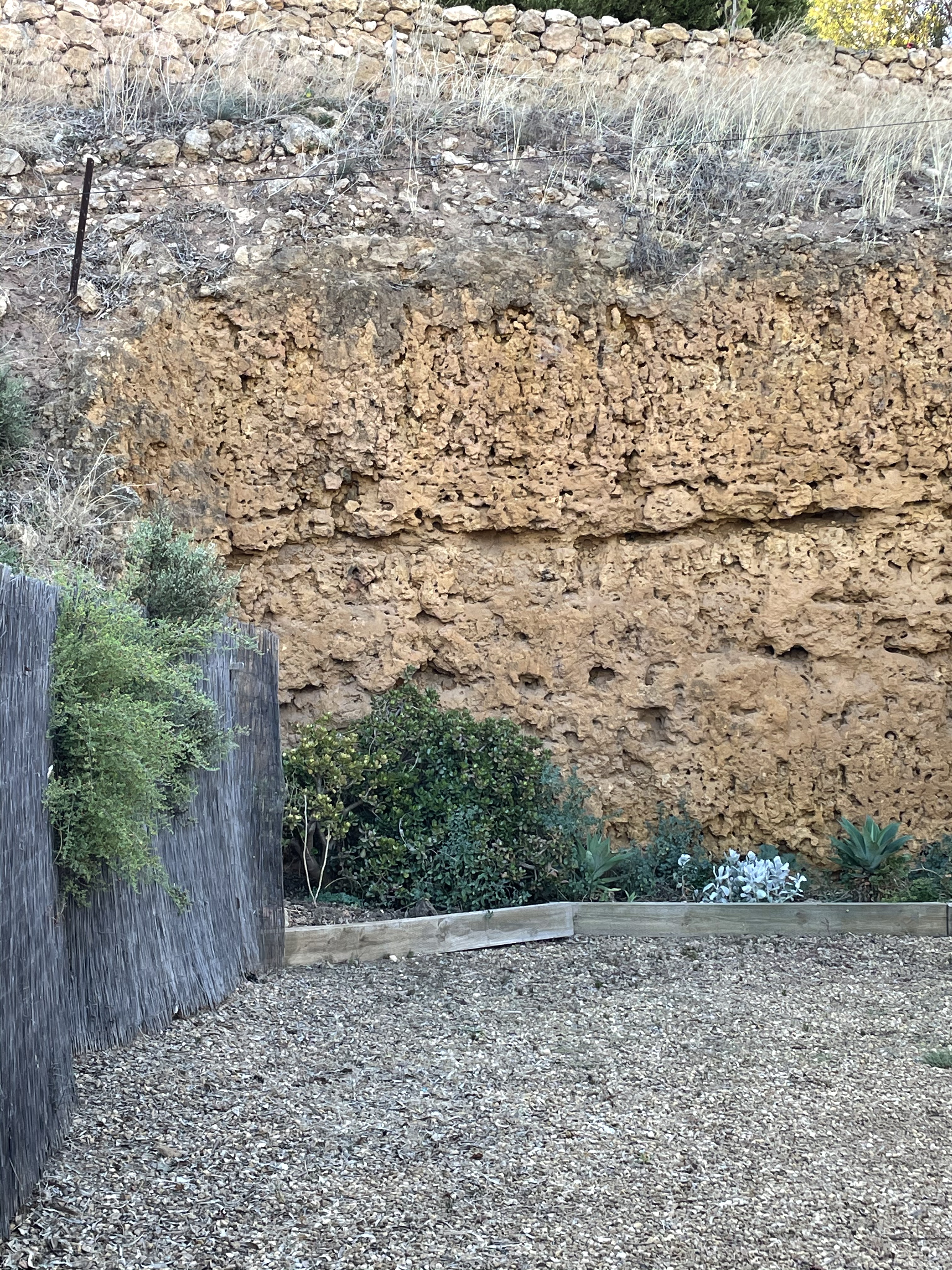
Now we’re ready to begin our journey, at the east side of the rectangle outlined in blue from Fig. 2. Erosion along the banks of the Murray River exposes Cenozoic (66-0 Ma) sedimentary rocks that are poorly consolidated but resistant in the low rainfall of this region (Fig. 6).
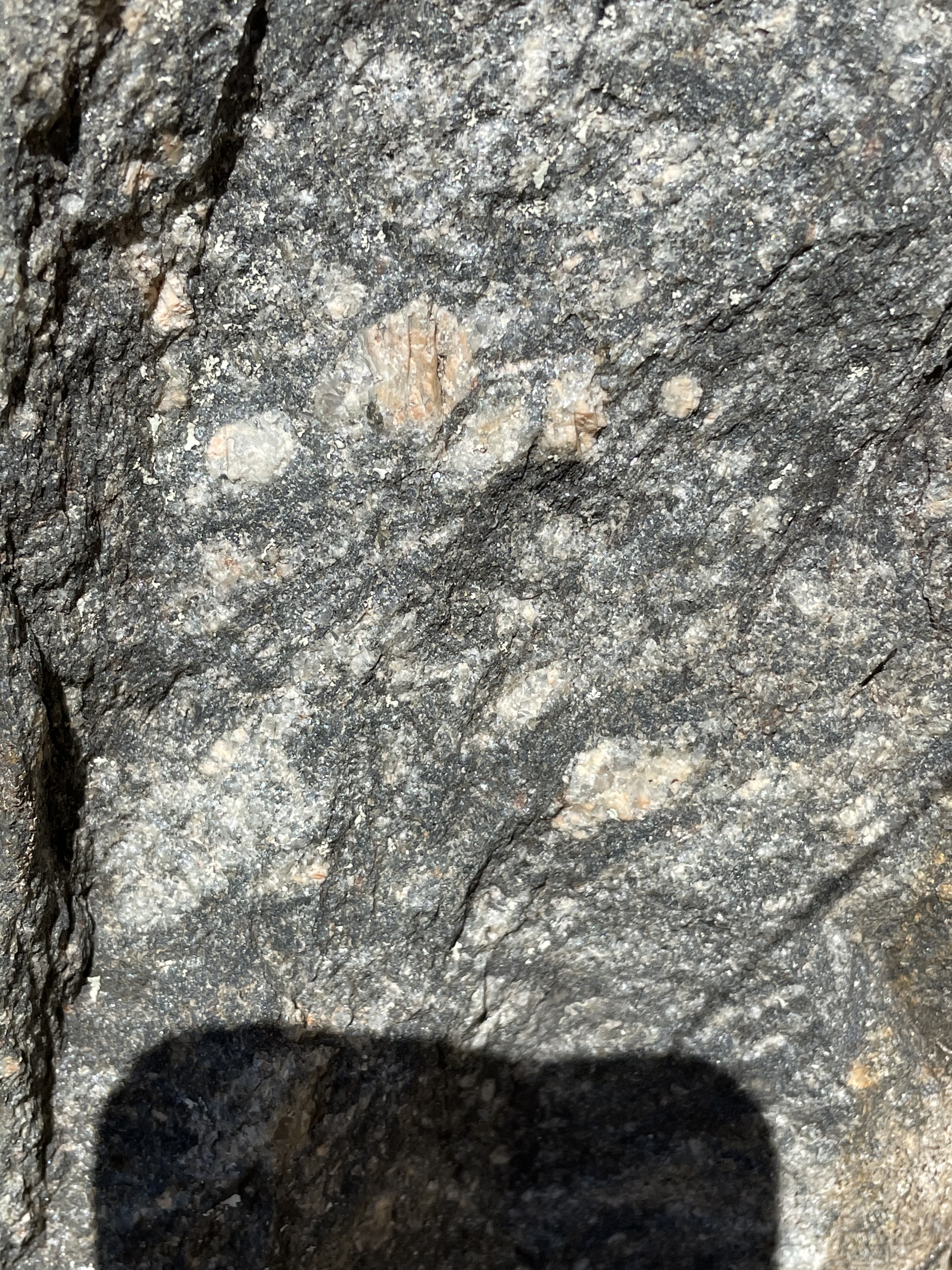
Heading WNW from the “Starting Point,” our path took us over some rolling hills capped by rounded exposures of what turned out to be alkali granite (Fig. 7), which is about 500 Ma old.

Viewed up close, this rock consists of quartz and alkali feldspars (i.e. albite and orthoclase), with minor biotite (Fig. 8).

This rock appeared capping hills but formed no cliffs or ledges. Within a mile of this outcrop we found the country rock (Fig. 9), Neoproterozoic to Early Cambrian (541-509 Ma) sedimentary siliciclastic rocks.
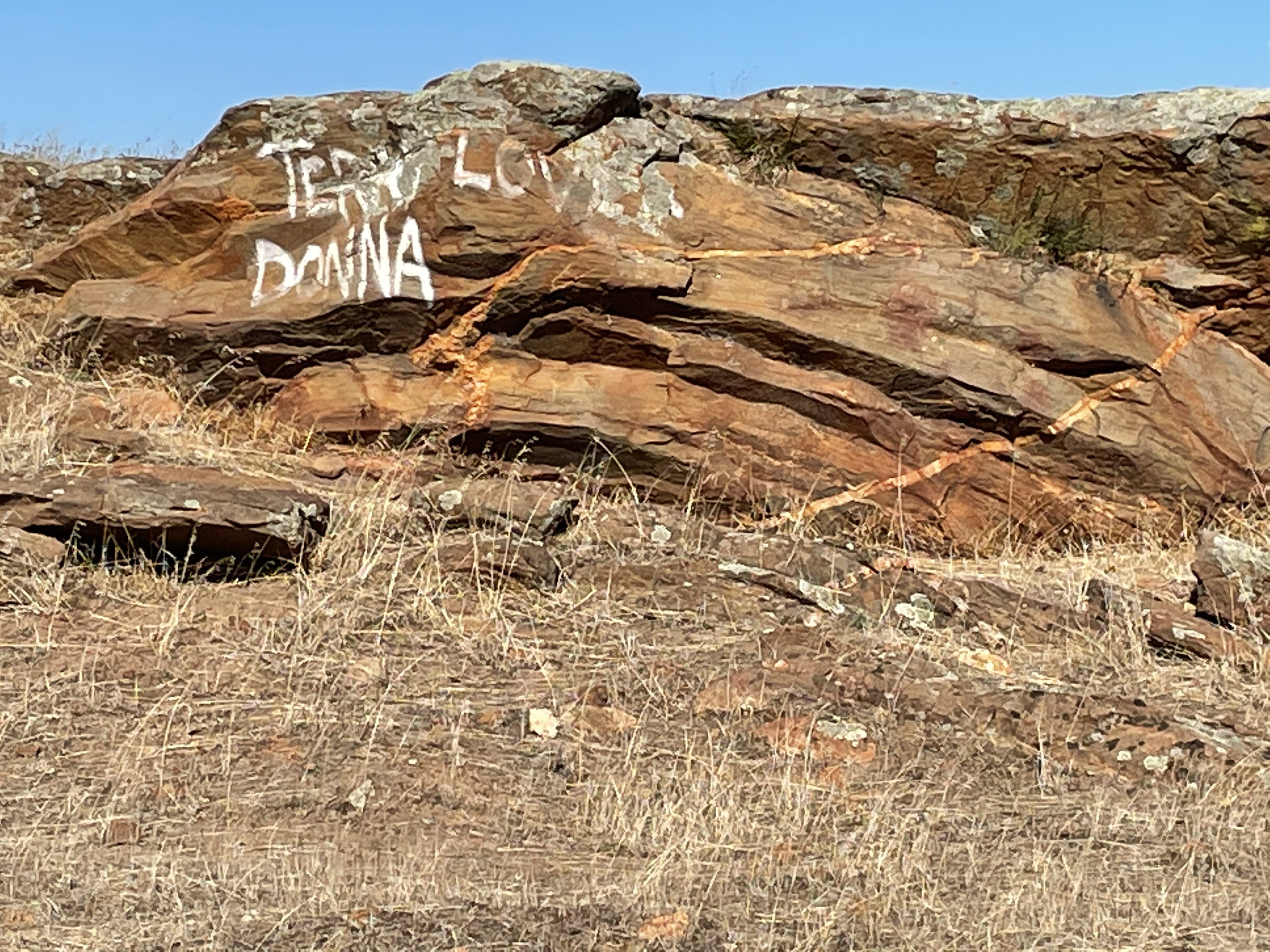

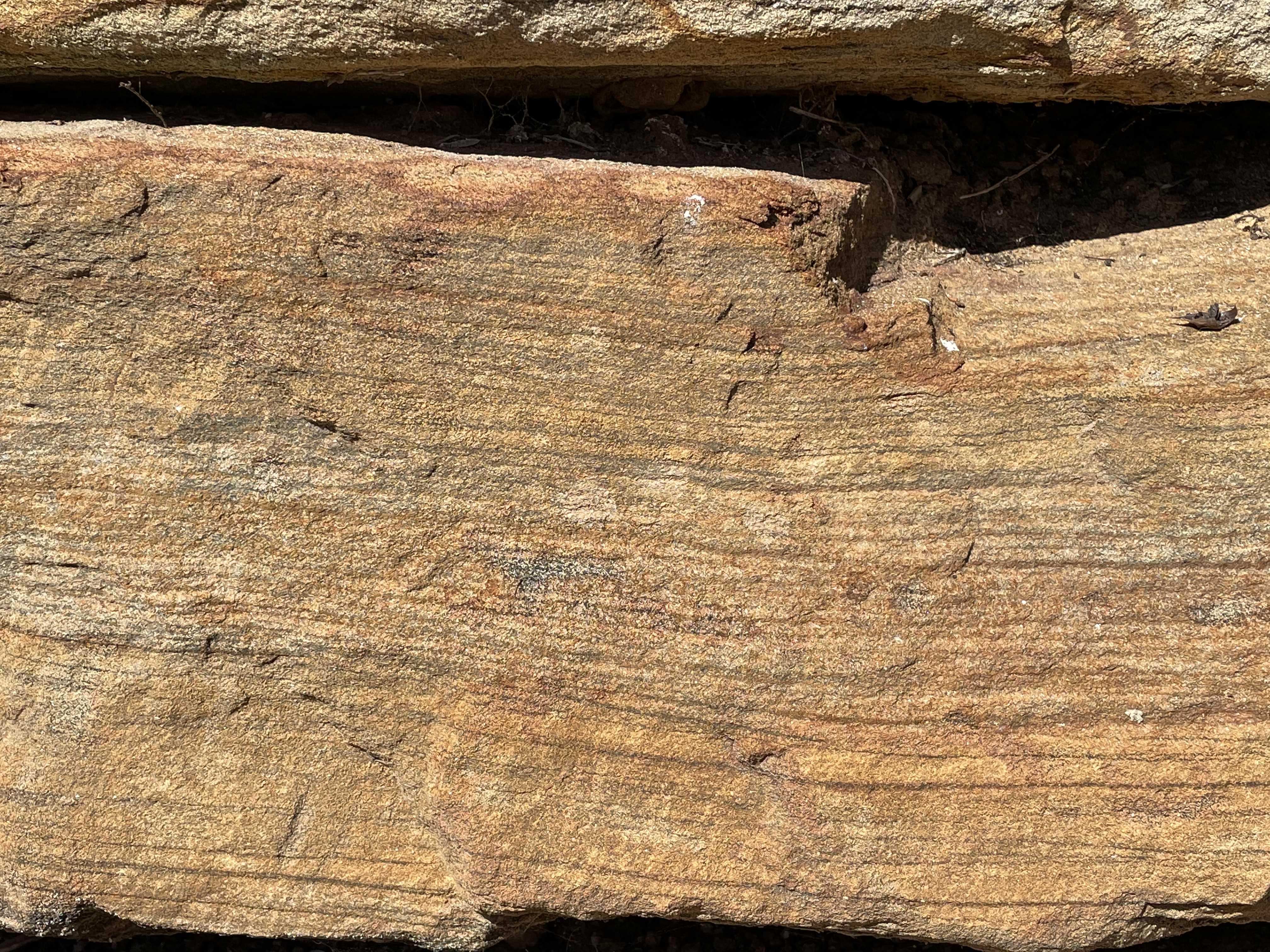
These exposures appear to retain their original sedimentary texture, comprising thin bedding and lamination. However, they are very near exposures of younger granite, which suggests an intrusive relationship during metamorphism. Note the dip of the beds in Fig. 9.
A freshly cut block (to make room for a fence) reveals foliation that suggests high-pressure metamorphism (Fig. 10).

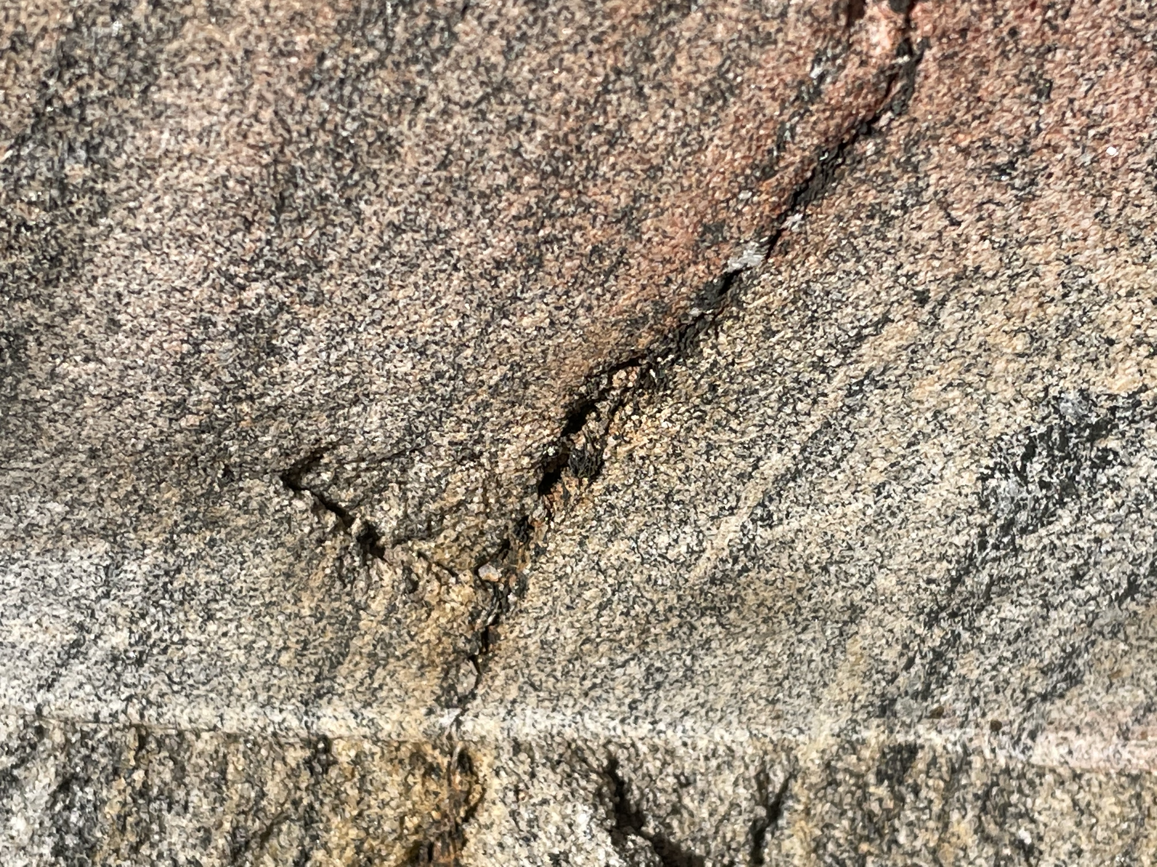

The foliation seen in Fig. 10 is bordering on gneiss, which isn’t formed until the minerals are near their melting point, which is consistent with the proximity of the Palmer Granite pluton (Figs. 7 and 8). Taken together, these rocks indicate deposition in a nearshore marine environment between ~540 and 510 Ma, burial to great depths, and intrusion of a granite magma about 500 Ma. This was an orogeny.
Traveling west (see blue-outlined inset in Fig. 2), we entered a canyon with exposures of metamorphosed sedimentary rocks (Fig. 11).


The range of sediments and their metamorphic grade seen in Fig. 11 span 1900 million years. They are exposed because of a major N-S fault running along the Flinders Range. The oldest (Figs. 11C, D, and E) are metasediments with foliation that were deposited between 2500 and 1000 MA.
The exposures in Fig. 11 A and B are from the Burra Group of Cryogenian age (720-635 Ma), long before the Keynes Subgroup sediments (Figs. 9 and 10) were deposited.
The Burra Group has a diverse lithology: laminated siltstone; sandstone with heavy-mineral lamination (e.g. from a beach), comprised of quartz and feldspar, with cross-bedding; dolomite (a carbonate); blue-grey to pale pink; containing lots of clay and lenticular (i.e., many lens-shaped bedding structures). Note that all of these sediments are indicative of a passive margin, not an orogenic belt experiencing rapid uplift and the deposition of immature sediments like graywacke and turbidites.
We followed Kangaroo Creek Reservoir (Fig. 12) to its outlet, where a large cut had been made, exposing two sides of a major fault.

The road along the west side of Kangaroo Creek (Fig. 12) had been following the fault, taking us into sediments of the Emeroo Subgroup (720-635 Ma), the same age as the Burra Group but containing only quartzite (metamorphosed sandstone), sandstone, dolomite, and conglomerate. Road cuts reveal the rock textures associated with a fracture zone (Fig. 13).


The major fault that runs the length of Kangaroo Creek Reservoir is exposed at the reservoir’s outlet (Fig. 14).

Note that the rocks in Fig. 14B are darker than those on the south side. Both sides of the fault expose rocks from the same stratigraphic formation but within different units. The south side (Fig. 14A) could be either quartzite or possibly dolomite because both can have a similar color. No exposures were available for close examination, however, so I’m going to put my money on dolomite. Such a large exposure of quartzite, from my experience, would either show bedding or be massive, whereas there are irregular lineations in this exposure. Dolomite is a carbonate mineral, formed by the recrystallization of the original calcite that would have formed marine animal shells in the ancient seas. The transformation from calcite to dolomite during diagenesis is not well understood. Thus, it can take many forms whereas sandstone is quite limited.
No report in Australia would be complete without the final photo from a beach. We ended up on the main public beach serving the Adelaide region (Fig. 15), to discover that it is a disaster compared to the “unimproved” beaches we’ve seen elsewhere in our travels.

The groin in the distance prevents sand being transported to this beach by waves and so it is starved of sediment. Thus, the nearshore bars and high berm to the left of the image. The beach face had a large component of fine-grained sediment as well. The beach was less than a mile long, terminating at the west end at an opening to a lagoon.
Summary
This is the last post from our trip to Adelaide, so I’ll summarize the geologic history briefly.
Between 2.5 and 1 billion years ago, South Australia was a passive margin (like the East Coast of the U.S.) and a variety of sediments accumulated in every imaginable coastal environment. Then there was a hiatus of about 300 million years, indicated by an unconformity between the Barossa Complex and Burra Group. A lot can happen in 300 million years, including an orogeny and subsequent uplift and erosion of the sedimentary record of such an event.
Between 720 and 635 million years ago, this region was a passive margin again, receiving similar sediments as a billion years earlier. These sediments were deposited on a surface that represented 300 million years of lost time. I didn’t find any dating of the orogenic event that produced the metamorphism seen in Figs. 11C, D, and E. Maybe it occurred during that missing interval or maybe…
The Delamerian Orogeny lasted from ~515 to 490 million years ago, long after the Burra group sediments had been buried and lithified.
The youngest Paleozoic sediments (the Keynes Subgroup, Figs. 9 and 10) were deposited between ~540 and 510 million years ago, overlapping slightly with the Delamerian Orogeny. However, the 105 million year hiatus between the Burra Group and the Keynes obscures a lot. For example, a little over 200 million years ago, North and South America were connected to Eurasia and Africa. Like I said, a lot can happen in a hundred million years.
At any rate, a series of granitic intrusions occurred, pushing their way into older sedimentary rocks, about 500 million years ago. This led to more metamorphism and deformation, probably associated with the Delamerian Orogeny.
Erosion followed until the Cenozoic (less than 68 million years ago), when terrigenous sediments accumulated everywhere, as revealed along the Murray River (Fig. 6).
Within the last couple of million years, Australia drifted over a mantle plume and volcanism began in Victoria, several hundred miles to the east near Melbourne, producing vast sheets of basalt.
This story is missing a lot, which we saw on previous trips. I’ll tie them together in a later post.
Drive to Adelaide, SA: Paleozoic Sedimentary Rocks
Today’s post covers the drive from Site 1 to Site 2 (Fig. 1), going from Quaternary volcanics to folded and faulted Paleozoic sedimentary rocks. The latter are presumably similar to the rocks that hosted the original magmatic gold that was eroded to form alluvial ore bodies like at Sovereign Hill.

Site 2 (from Fig. 1) can be expanded to show details of our movements within Grampians National Park (Fig. 2). Figure 2A shows the topography of the entire mountain range and the inset (Fig. 2B) is the first location we visited (Site 3).

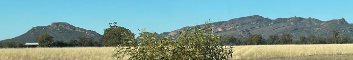
The quaint tourist town of Halls Gap was entered through a narrow opening in the frontal ridge, seen to the extreme right side of Fig. 2B. Looking up from town, the ridges can be seen to form cliffs and dip generally westward (Fig. 3).

Figure 2 suggests steep cliffs on the east side of the ridges, as indicated by darker shading, and lower slopes on the west. The yellow-filled area in Fig. 2B is a uniform block that is tilted westward, which will be shown in detail below. Our path took us west of this fault block. The road is indicated by a white line pointed westward. A circuitous path took us eventually to Site 3 and afforded an opportunity to examine the rock up close (Fig. 4).
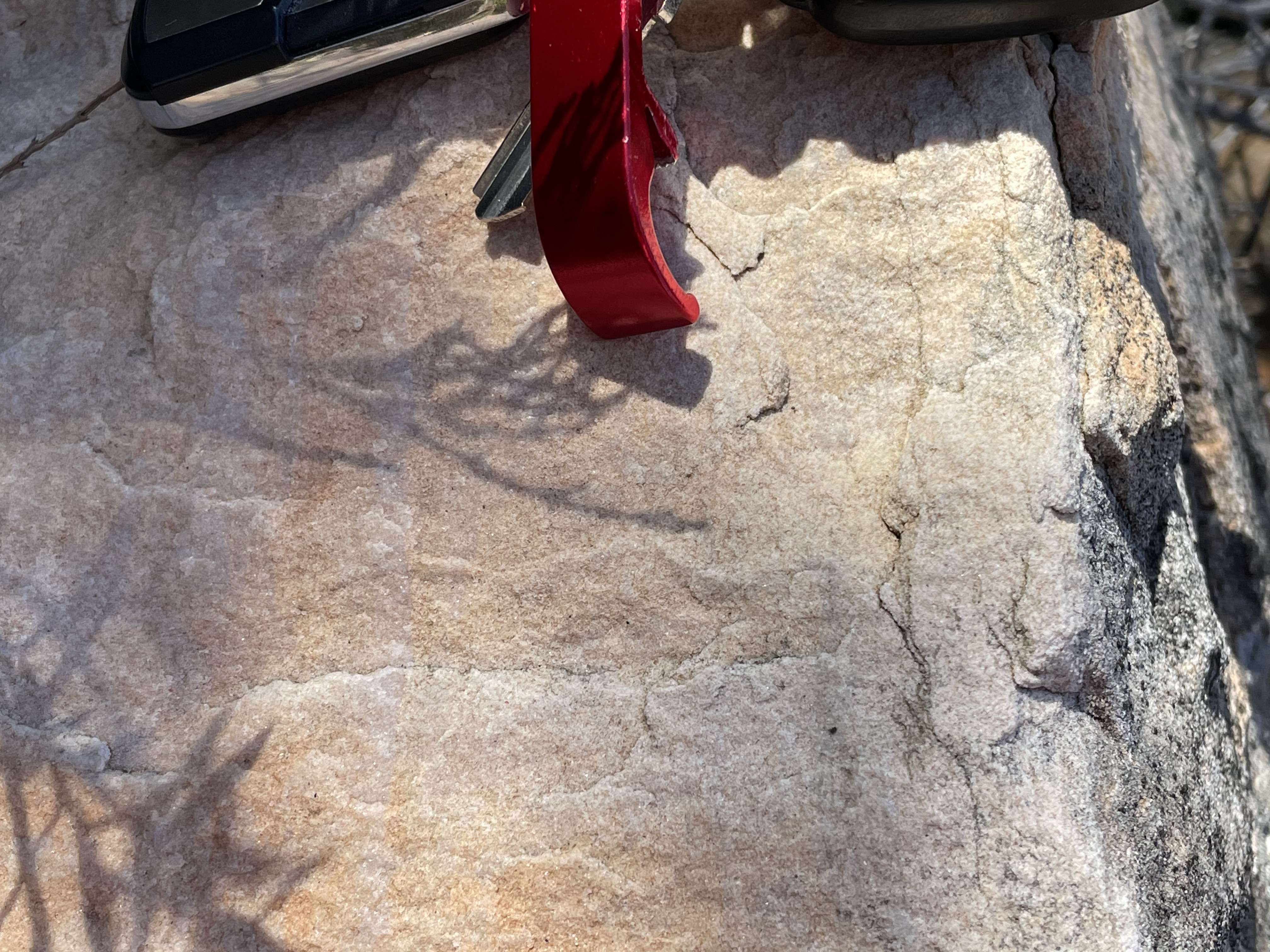
This is a well-sorted sandstone. According to RockD, it is the Grampians Group, marginal marine and fluvial sandstone with some red mud and conglomerate (444-427 Ma). This sample doesn’t show any crossbedding or other fluvial structures but it is fairly uniform in texture. Furthermore, zooming in on Fig. 4 reveals that the grains aren’t as rounded as we would expect from a beach or marine sand, which has been worked by wave action. The reddish hue is another indicator of a fluvial origin because marine waters have less oxygen and don’t oxidize iron within the cement. Oxidized iron (rust) comes in many hues of red.
The view from Site 3 (Fig. 5) reveals Lake Bellfield in background and the fault block shaded in yellow in Fig. 2B in the foreground. Note the uniform surface dipping to the west. This is a bedding plane and it was originally horizontal. Note also how the cliffs in the center-right of the photo are nearly horizontal. This suggests folding, which is associated with compressional tectonics. Keep in mind that these rocks were buried several miles beneath the surface when deformation occurred ~400 million years ago.

As it turns out, the rock layers are not uniformly dipping to the west as suggested by the topographic map (Fig. 2). For example, at Site 4 (see Fig 2B for location), the following view (Fig. 6) shows the variability of the mountains as seen from the ground.

Looking first to the southern end of the range (e.g. Zumsteins in Fig. 2A) shows the kind of appearance that the westward dipping fault block in Fig. 5 would imply (Fig. 7A).
Figure 7. Close-up shots from Fig. 6.

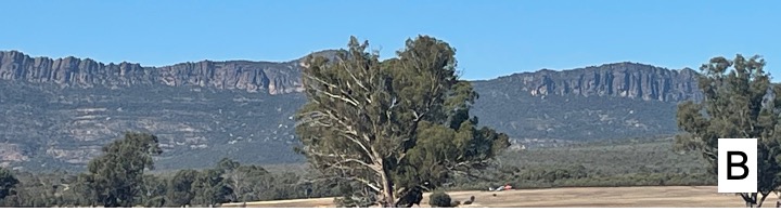

Figure 7B, slightly to the north, reveals high cliffs somewhat further away, possibly east of Wartook (see Fig. 2A). The cliff is unbroken except for a saddle just to the right of the central tree. Further north (Fig. 7C), the ridge is in the foreground and a higher ridge, facing east, forms the skyline. This location is about where Laharum is located in Fig. 2A. Thus it would seem that faulting was not uniform. No where is this more evident than just north (to the left) of Fig. 6.
The southern (right side) rocks tilt to the north whereas the northern (left side) tilt to the south. Glancing at Fig. 2A, we see that the V formed by these fault blocks is at the narrowest (and lowest) part of the ridge they form.
Taken together, these observations suggest that deformation was not a simple process here, just as observed in previous posts. The geologic map (Fig. 9) reveals several faults in Grampians National Park.
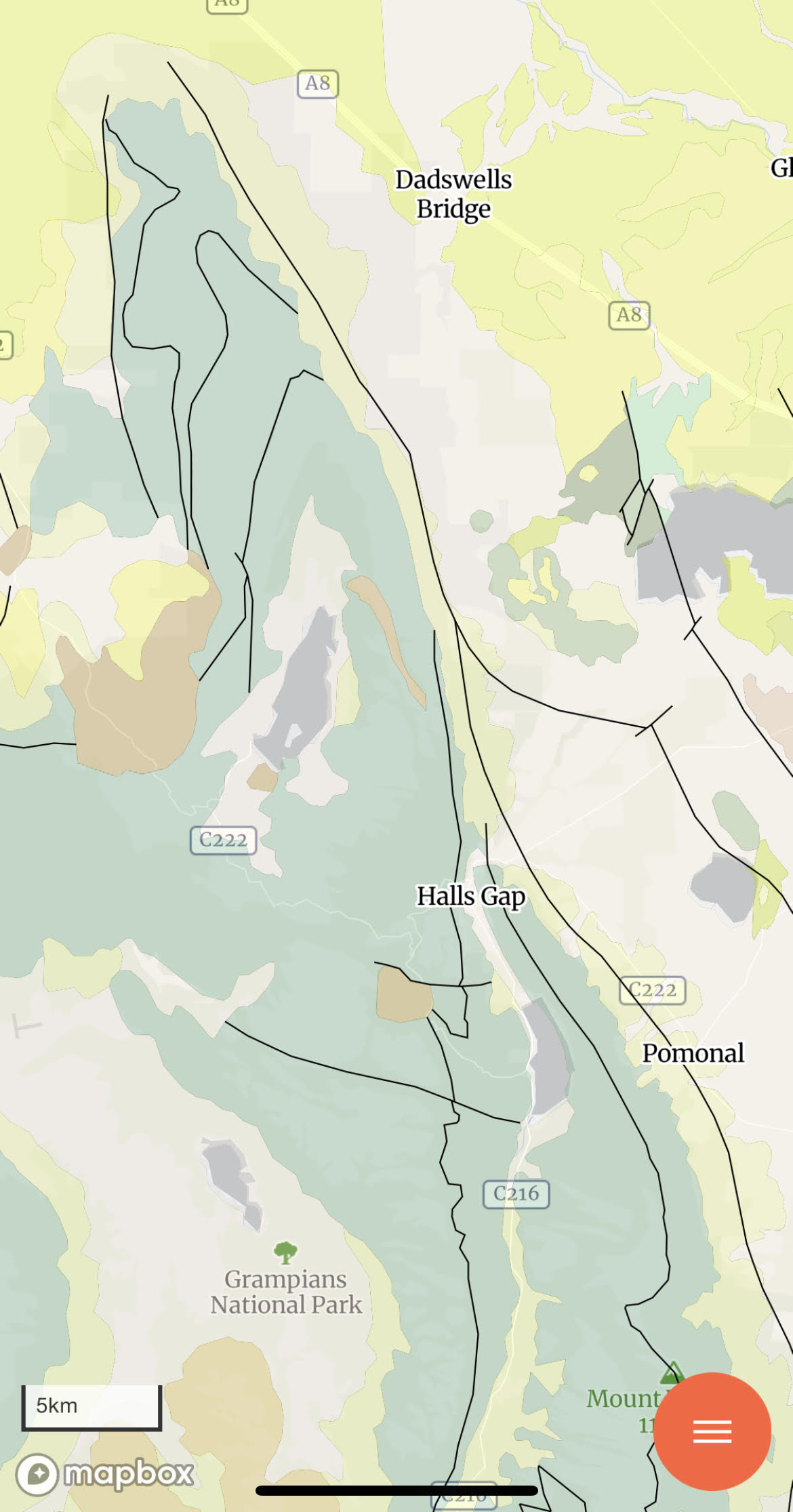
The map reveals several N-S trending faults along which the huge blocks seen in Fig. 2B and Fig. 5 tilted to the west. It also shows nearly orthogonal faults (e.g., south of Halls Gap), and curved ones near Dadswells Bridge. This suggests that folding may have occurred after faulting. One possibility is tectonic inversion, in which (for example) a stress field changes from extensional (e.g., before 450 Ma) to compressional (e.g., after 400 Ma). Such an inversion of tectonic stress would reactivate old faults and deform them, as well as allowing thrust faults (compression) to occur on previous normal faults (extension).
Just an idea…
Drive to Adelaide, SA: Quaternary Volcanics
The next few posts are going to document and discuss some of the geology we encountered on a drive from Melbourne to Adelaide, South Australia. The border between states is open now so it was no problem. The total trip is about 450 miles in length. We took three days to make it all the way. This post is going to present our observations from the morning of the first day, to keep the post shorter. I know I get carried away sometimes.
Figure 1 shows the geologic map of the part of Victoria covered on the first day. This post wlll discuss Location 1 only.
The volcanics were erupted over older rocks, in this case Paleozoic sedimentary rocks that had been intruded by granitic magma during the period of mountain building discussed in previous posts. Gold was deposited in fractures and faults at that time. Later, as the mountains eroded, the gold was deposited in rivers and because of its resistance to weathering, and collected in significant deposits. This kind of gold deposit is called alluvial. The Sovereign Hill mine was the site of the richest alluvial gold rush in the world, with one nugget weighing more than 150 lbs.
The location of the original shaft (Fig. 2) is now a tourist site. The underground mine play ran out and less expensive methods became employed to recover the ore.

Underground mining produces large piles of ore (Fig. 3), which mark the location of mine entrances throughout the world.
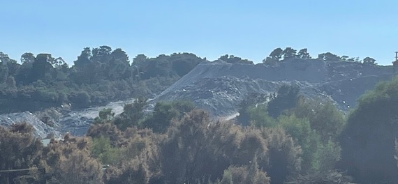
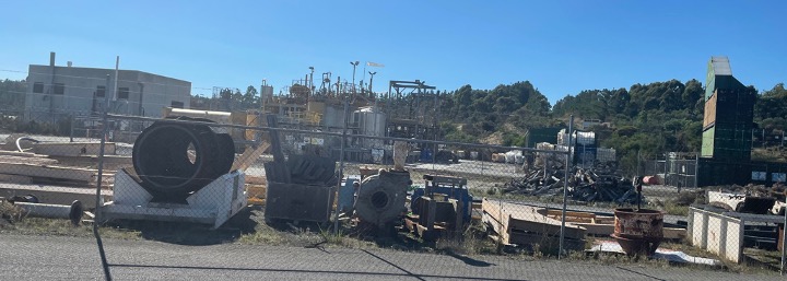
There was a mining project still going on, however, out of sight of the tourists, on the other side of the hill (Fig. 4).

I’m not sure if the operation is working directly on low-concentration sediments or simply created a large basin for the highly toxic waste products produced by acid-leaching methods. We didn’t see any evidence of large earth movers or dump trucks, however. This involves a lot of on-site chemical processing (Fig. 5).
As already mentioned, the gold was located in Paleozoic sedimentary rocks beneath the Quaternary volcanic rocks. As seen in Fig. 1, this was an extensive volcanic field, which implies that there should be volcanoes still to be found because of the young age (< 2 Ma). A topographic map of the area in fact reveals the presence of many volcanoes (Fig. 6).

Here’s what those volcanoes look like from a distance.
Figure 7 shows a large number of volcanoes, like where the most eastward arrow in Fig. 6 is pointing. They were covered in grass and were used for grazing sheep mostly. We couldn’t get access because they were all on private land and, surprisingly for Australia, there was no volcano park or anything…

As seen in Fig. 1, in some locations the older Paleozoic rocks were present at the surface (Dark blue in Fig. 1). The terrain here consisted of rolling hills, occasional ridges, and volcanoes. The ridges may be the surface expression of folds in the older rocks, created when the intrusion responsible for the gold mineralization occurred. That was back about 400 Ma in the past, however. At any rate, Fig. 8 was taken on a downhill slope from one of these ridges, showing an unusually large volcano in the distance, possible the complex near the town of Ercildoune in Fig. 6.

That’s it for this post. We finally drove through the volcanic complex we’d heard about and, although we couldn’t visit any volcanoes ourselves, it was inspiring to drive through so many volcanoes, to imagine what it was like when they were erupting the massive volumes of lava seen in Fig. 1.
Next time, we’ll continue to the west to examine some Paleozoic sedimentary rocks that have been folded and faulted.

Recent Comments