
Lone Star Jamboree Epilogue
This trip is harder than it looked from a geological perspective. Younger rocks like the Eocene Queen City Sand show more details than we can see in Paleozoic rocks like the Hartselle Fm. in N. Alabama. This makes it difficult to make sweeping statements about them. Anyone who has visited the central Gulf of Mexico knows it looks muddy, but the sand lies at the bottom and wherever the waves are strong enough to remove the finer clays. The ledges of Barwnmell Mtn. are mostly mud as described in the previous post, but there is no clear separation of mud from sand in a delta, where enormous amounts of mixed particles arrive from rivers like the Mississippi River. This photo was taken with a 15x macro lens on my iPhone. It shows sand grains in the shale sample I discussed before.
Most of the shiny particles are sand grains. This is important from a wheeling perspective, because even a little sand in a fine matrix improves traction (like the paint we buy for porches and garages). Both of the samples I collected contained these sand grains.
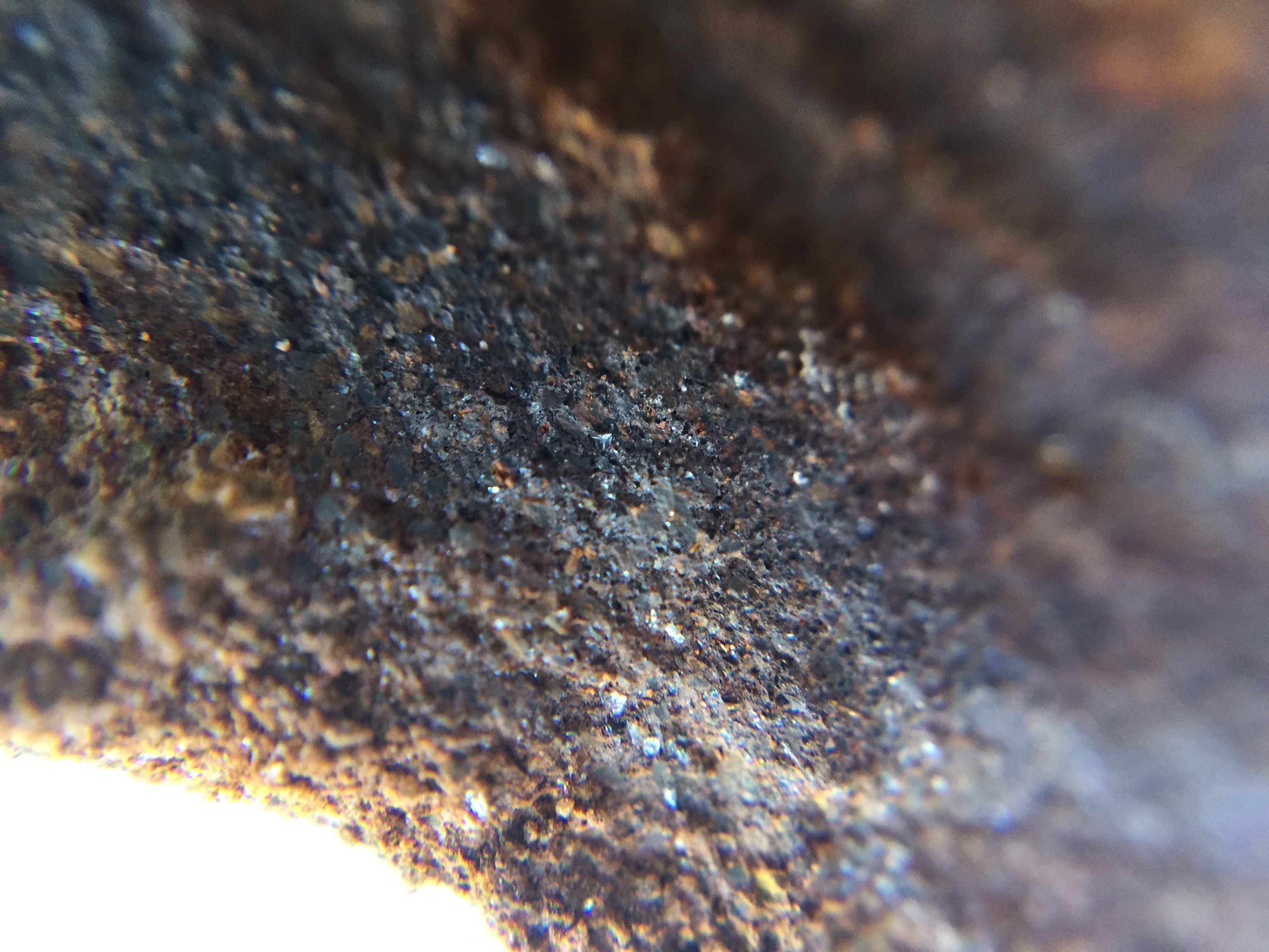
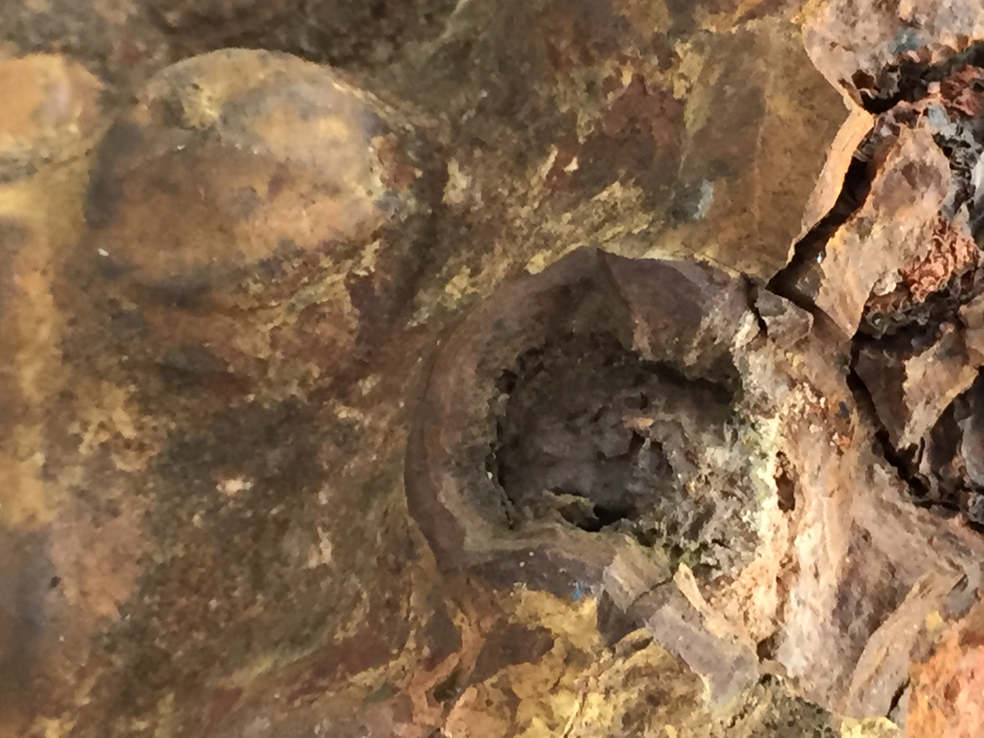
The next major issue I discerned from my samples and trip was the red mud, which is the result of oxidation of iron (Fe) with lots of oxygen. The samples were both dark grey inside, which indicates no iron oxidation The red color seen in concentric zones in my samples, and the entire mountain, was from exposure of these sandy shales to the atmosphere as they erode and fracture. This photo with the 15x lens shows the amount of void space (i.e. porosity) in these rocks.

Note the small pores seen in this image, which fill with water in this part of Texas, but with oil far to the south. I can’t explain easily the blue color, which was not seen until the magnification was this great.
This brings me to the last (almost) point I want to take from this trip. The sedimentary rocks deposited in the SE U.S. (specifically AL and TX) contain a large amount of iron, which produces iron ore (e.g. Birmingham was the only major iron production center in the south prior to the U.S. civil war). These rocks also contain so much Fe that they must be filtered for consumption from water wells in NE TX. Geologists don’t know why because the source rocks for all of this Fe are long gone (they’re remnants reside in these rocks and the Black Warrior Basin of AL). Iron has been mined from carbonates (limestone) in PA from this geological period, but that is another story. The bottom line is that when ocean (aka marginal sea) circulation is just right, there is not enough oxygen to keep Fe active (so to speak). This is very localized, which brings me to my final point.
This photo from Wikipedia says it all. Just look at all of those thin strands of land and the isolated bodies of water that separate them…

Enough said about my limited understanding of NE TX geology, but it does make for interesting wheeling…next stop, Colorado…see you there and then!
Geology and wheeling upside down
This post isn’t about somebody overturning (I don’t think anyone did), but the reversal of expected geology in mixed sand/mud environments. I start by referring to the wheeling experience at Hawk Pride, where we fought mud that was produced from weathering (erosion) of shale and sandstones. There, we found boulders of Hartselle Fm. sandstone in a hillside with lots of shale/mud, where the ledges (an offroad term for a hard climb over a solid layer of rock) were the more resistant sandstone. BUT, those were 300 my old sediments where the quartz grains produced a silica cement, which made the “sandy” layers really hard.
As I mentioned in a previous post, these rocks are only 50 my old, and the sandstone is not cemented, which is why the layers (in total) are called the “Queen City Sand”. Here is a (poor) image that shows what I mean…
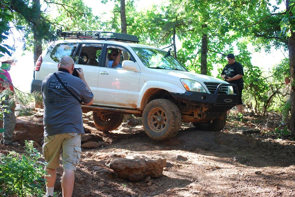
The vehicle in the image was dragged (by winch) over a 2 foot ledge of hard rock, which can be inferred from their exit (sorry about the poor trail photos, but I forget to take them when I am worried about my own escape…a work in progress). The ledge was composed of shales like I showed in the previous post. Here is another photo of a hand sample from this area. The rock doesn’t have as many organic components but it is as resistant.
This post is difficult to write because I didn’t take enough photos of the trail geology, but it is important to learn one lesson…time heals all sedimentary wounds…the young Eocene rocks (~50 mya) haven’t had time to heal all wounds. I mean that the organic material was still observable in a hand sample, and the sands didn’t supply silica (aka SiO2) to cement them as with older rocks. The result is that we were attempting to drive over hard shale (aka mud) layers while the sand formed nice traction surfaces to approach these ledges.
I will try and tie the environmental, geological, and wheeling aspects of this trip together in the next post, the epilogue…
After the mud dries: Wheeling in nearshore sedimentary rocks
Barnwell Mountain consists of one geologic formation, the Queen City Sand. As suggested by the linked report, and others related to water wells in the NE TX area, this formation comprises unlithified (not cemented) sandy layers and muddy layers that are somewhat more resistant to erosion. This formation has been described (reference unknown but government agency source) as a primarily sandy unit that was deposited in a constructive coastal environment (i.e. more sediment than could be transported away) that was part of a lobate delta system, including delta plain, delta front, and prodelta facies (i.e. sedimentary depositional environments). This is a concise description of the Mississippi River delta today, with numerous inactive deltas, lots of sediment (especially mud), and a wave-dominated sandy barrier island system where the river finally must deal with the ocean head-on…
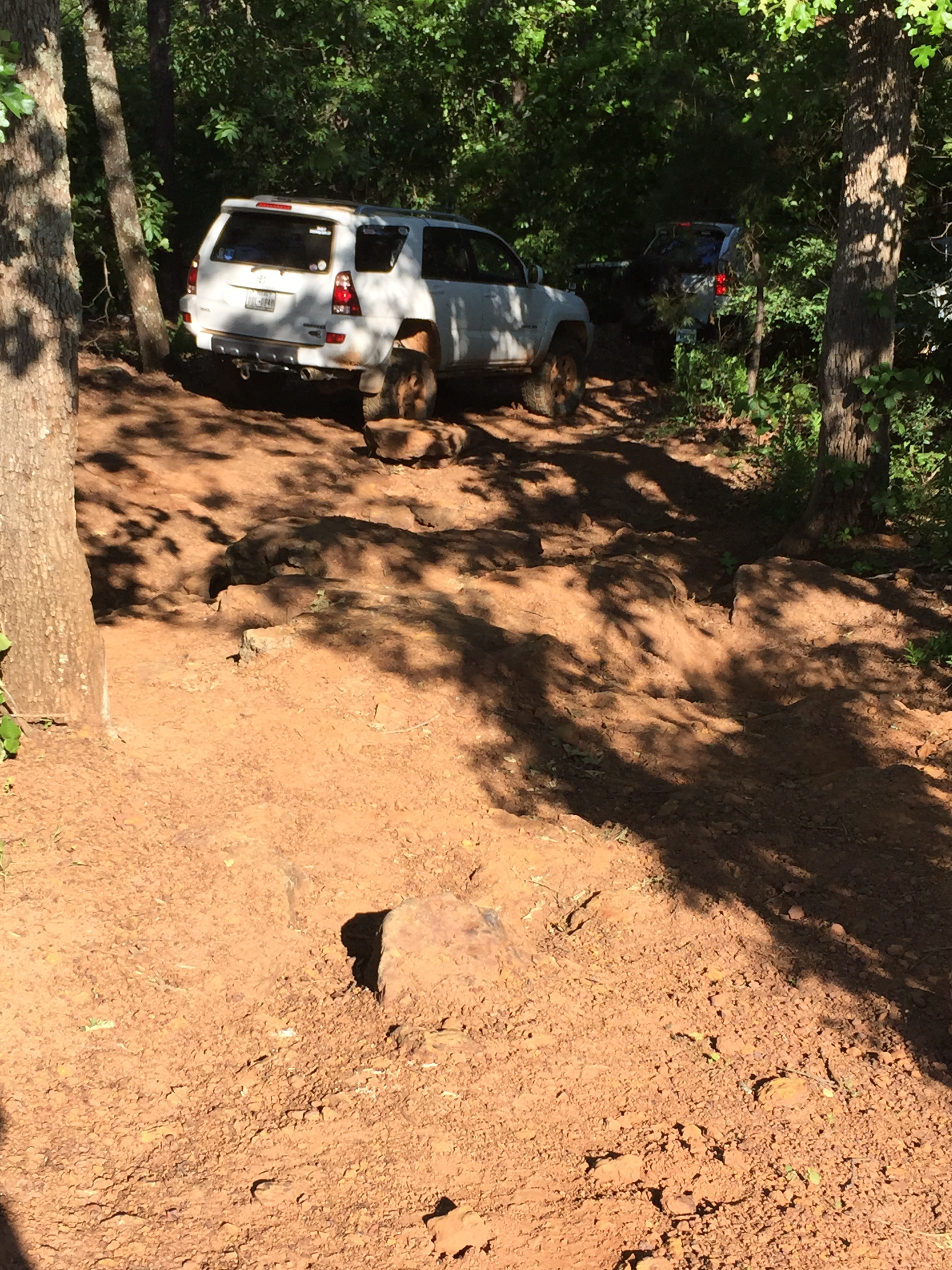
I took a nice photo of an outcrop within the geology compass Ap but it cannot apparently be downloaded…here is a photo (actually more useful) of the blocks of nodular, fossiliferous, dark grey mudstones that formed ledges (<2 feet high) and erosional blocks within the park.
It is a quirk of younger rocks that the sandy layers are difficult to cement because of the great pressure and temperature necessary to recrystallize quartz into a silica cement (microcrystalline), whereas mud can be lithified more easily because of all of the organic contaminants found in fine-grained sediments in coastal environments. The result of this is that there is a lot of sand found all over the mountain, but no obvious source because the mountain is made of sand (maybe some weak cement but not silica). Here is a photo of a sample I procured from the campsite, which is representative of other layers in the park.

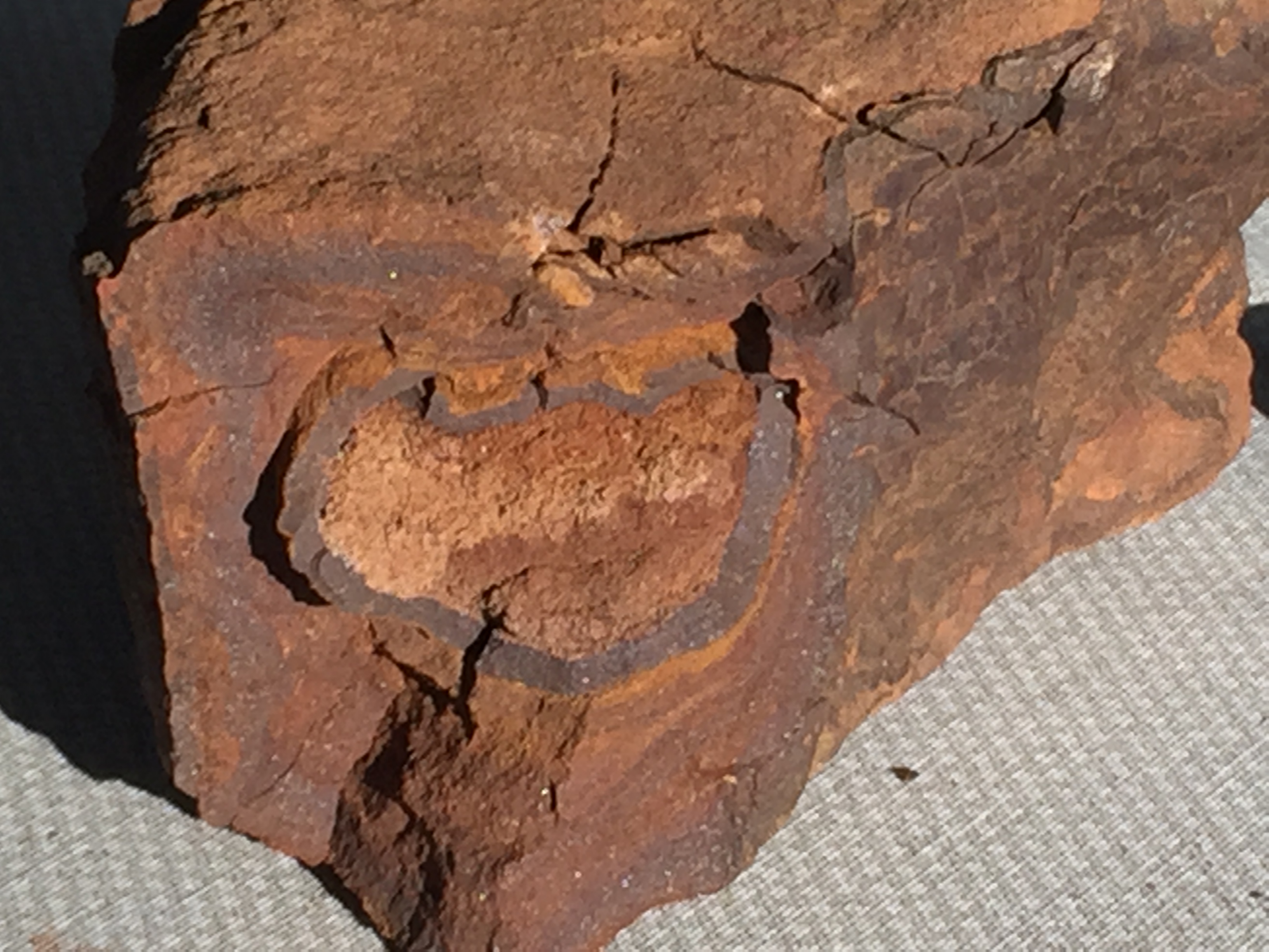
Note the nodular surface that almost looks like walnuts. This is another example of how bedding layers, like the surface of this sample, are produced by chemical and not physical processes (enough about that!). When I broke this open, it almost looks like some mud from the slough behind my house…
This photo shows the walnut/nodular surface and inside one of these nodules. We see concentric layers based on slight chemical differences in the original mud, and some darker, partly recrystallized, dark matter that is probably a piece of wood (very resistant to recrystallization,,,I think?) or other crap…geologists must use very expensive methods like electron microscopy to identify these kinds of substances. The gaps in the pore space are obvious…these would be filled with water, gas, or (Texans hope) OIL. The next photo shows how much these Eocene (~55 mya) sedimentary rocks resemble modern sediments (a Hoorah for Uniformitarianism)…

This sample is difficult to describe…it contains a lot of “stuff” that is apparently biological in origin, a lot like the muck I dig out of the slough behind my house. Some of the material even has a lighter color, suggesting it is quite different mineralogy or even original material, but I have no idea about this without more thorough study of the sample. I will close this post with the thought that mud is mud is shale is mud, ad-nauseam!
Wheeling in Eocene Delta Sediments
As noted in the prologue post, we moved back in time as we travel northeast, just as in driving to NE Alabama. The difference between these two drives is the time-interval covered by our 8-hour drive; we time-traveled 330 my (million years) to go to AL whereas the trip to TX only covered about 60 my.
The ancestral Appalachian Mtns. were located all along the eastern seaboard as they still are today. All of those rocks and the titanic collision with Africa pushed the earth’s crust downward as well as upward, as vast quantities of sediment were eroded from the rapidly rising mountains. Thus, the Mississippian Era (~330 mya) rocks deposited in NE AL were buried deep (and produced oil and coal because of it), but the crust has rebounded over the last several HUNDRED million years and these old, previously deeply buried sediments from a delta are now exposed at Hawk Pride ORV park.
When I drove to Gilmer, instead of seeing a regular, albeit incomplete (due to erosion) stack of sediments, I drove over Pleistocene (<2 mya) terraces produced by changes in sea level on a relatively stable coastline. There were also missing rocks as in Mississippi, especially the gap between the Pleistocene terraces (~2 mya) and the Miocene rocks we encountered near Natchitoches (~20 mya), and the even longer diastem (missing rocks) between the Miocene and Eocene sediments we will see in Gilmer (~40 mya). As we get into older sediments, they become more uniform (i.e. the smooth transition from Eocene to Paleocene near the TX-LA border on I-20.
This post is intended to remind me of the similarity of the rocks and history on the east and west sides of the MS embayment, which has little to do with the ancestral Appalachians but it does overprint its impacts on the older ones…We must always think 4-dimensionally with geology…LOL

Recent Comments