
Morven Park: Making and Breaking Pangea
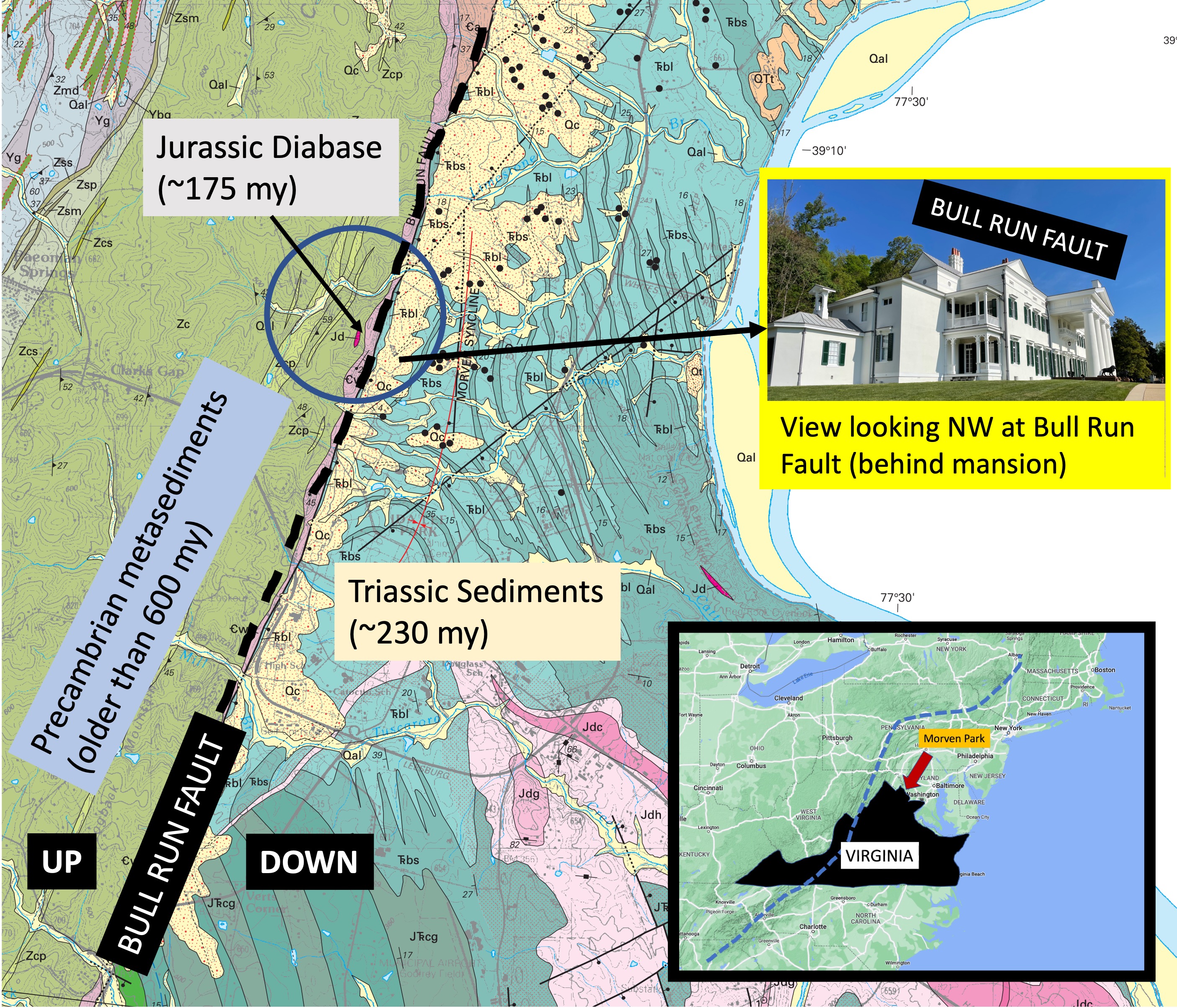
Plate 1. Geologic map of study area in northern Virginia (see inset map). The area is bisected by the Bull Run Fault (BRF, dash line), which separates older metasedimentary rocks from younger sedimentary rocks. The west side of BRF has moved upward relative to the east side, following the regional trend along the east coast of North America (dash line in inset map). The inset photo shows how BRF appears today, forming a topographic rise with less than 100 feet of relief. The study area (blue circle) is located on the western part of Morven Park, which is the location of a mansion (inset photo) occupied by an early twentieth century governor of Virginia, now a historic site, museum, and equestrian park. The image is approximately 4.5 miles across.

Plate 2. photos of an outcrop of Catoctin Formation metamorphic rocks from the southern end of the study area (see Plate 1). These rocks are between 1 by and 540 my old; they were originally basalts, tuffs, sandstone, siltstone; before being buried and metamorphosed into their current lithologies. This plate shows the outcrop along strike (A) and along dip (B), revealing sedimentary structures and grain sizes that suggest this is a cross-bedded sandstone with intercalated siltstone. These sediments (and associated volcanics not seen in the study area) were deposited when proto-North America collided with proto-Europe during the late Proterozoic. They were then buried deeply enough to be altered but not so much to become gneiss, or melt to become igneous rocks. Their current orientation has a strike of 35 east of north, and a dip of approximately 30 degrees, but this deformation was not caused during the collision that formed Pangea.

Plate 3. Close-up of the outcrop in Plate 2. The top of the sequence is a bed 12 inches thick. Below this is are several cross-bedded layers (identified by the lines that dip to the left) that are discontinuous, and intercalated with thin, massive (no lamination) beds. The lowest visible beds are lenticular in this view. This kind of cross-bedding suggests that these sandy sediments were deposited in a river, where one-directional currents create uniform cross-beds. There is no evidence of gravel and the sand is fairly well sorted (as best as I could tell from the outcrop), suggesting that this was not near the source but in an alluvial fan. The heterogeneous lithologies of the Catoctin Formation are likely due to delta switching, i.e., the main channel moving across a relatively flat area before entering either a sea or lake. There are no fossils in these rocks because they predate the appearance of shell-forming invertebrates like clams, snails, etc. There were no land plants either, so their organic carbon content is practically zero.
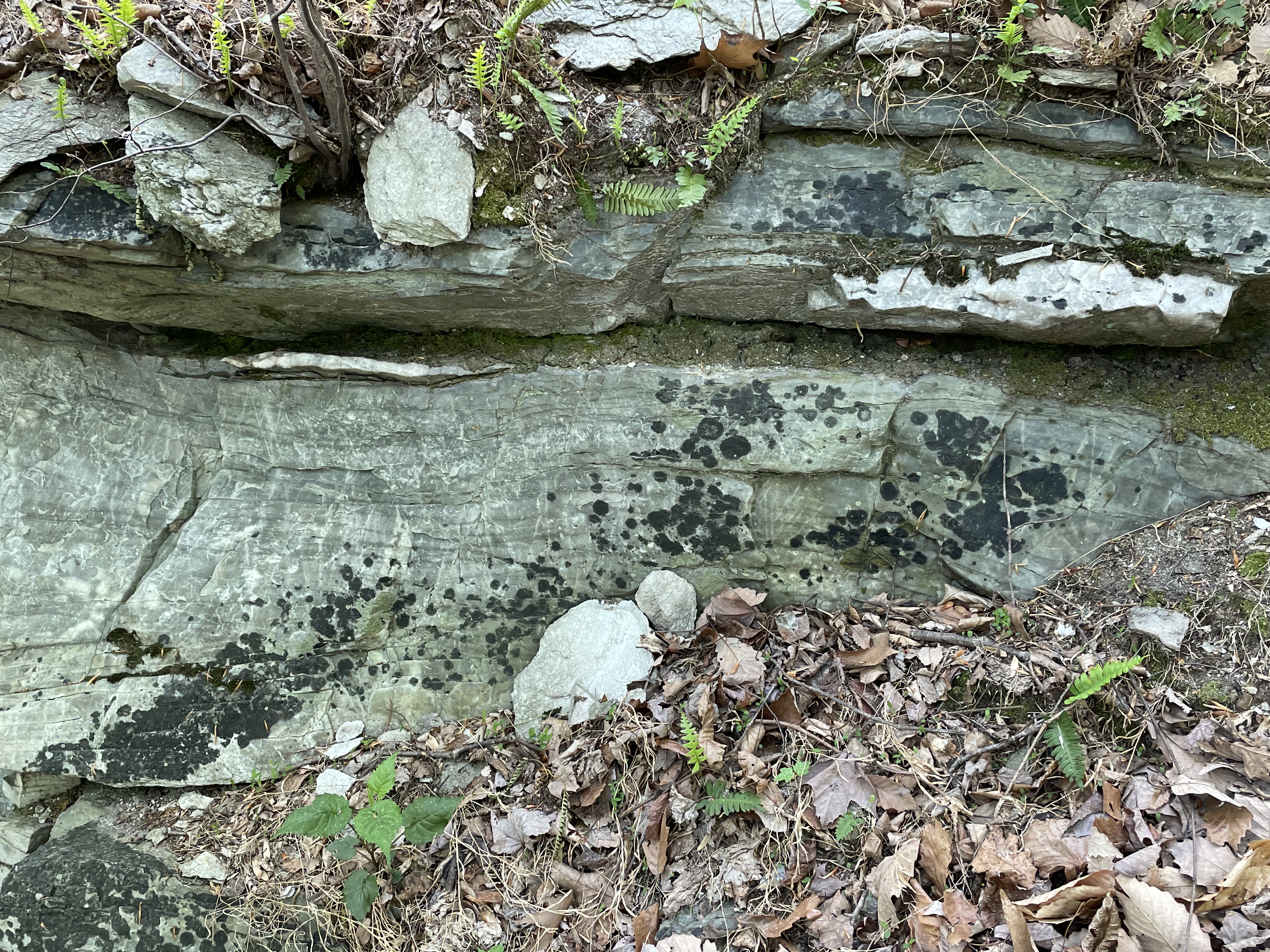
Plate 4. Close-up from the outcrop in Plate 3, showing lenses of white minerals within laminated, slightly folded sandstone beds. Such lenticular bedding is common in metamorphic rocks because of the high heat and pressure caused by deep burial. Incompatible elements (e.g., calcium or silicon) are squeezed out of the rocks and form blebs of new minerals, such as calcite (excess calcium) or quartz (excess silicon). There were no shell-forming animals (invertebrates form their shells of calcium minerals) when these sediments were deposited, but carbonate rocks have been produced by abiotic processes as long as 4 billion years ago; not to mention algal mats created by stromatolites. Marble (metamorphosed carbonate rock) is reported as lenses within the Catoctin Formation. These lenses would have been originally deposited as either algal mats or chemical sediments.

Plate 5. Close-up from Plate 3, showing details of one of the lenses. Note the lamination in the sandstone and transition between the two mineralogies where they are in contact in middle of the photo. I didn’t use acid to test for calcite (it fizzes under dilute HCL) because the motto of Rocks and (no) Roads is to use our eyes and available information. However, note the white rectangle at the top-center of the photo; it is very similar to the shape of calcite crystals. Other such shapes are visible if you open the image, zoom in, and pan around. I am going with this being a lens of calcite, crystallized from mineralogically incompatible calcium, because that is consistent with the official description of the Catoctin Formation lithologies.

Plate 6. Photos of phyllite found loose on the ridge west of the Bull Run Fault (see Plate 1). (A) The sheen of this sample is caused by aligned muscovite minerals during burial. (B) A close-up reveals the platy texture typical of phyllite, which typically forms from shale and is intermediate in metamorphic grade between slate and schist. The chemistry of these rocks suggests that they were originally deposited as tuff (a fine-grained volcanic deposit) rather than mud. Of course, once the ash settled it would have been transported by rivers and become intercalated with the sandstone seen in Plate 2. This sample shows no sign of stream transport (e.g. rounded into a cobble), so it is probably a remnant of eroded, overlying (i.e. younger) volcanic sediments, after the quiescent period represented by the older sediments from Plate 2.
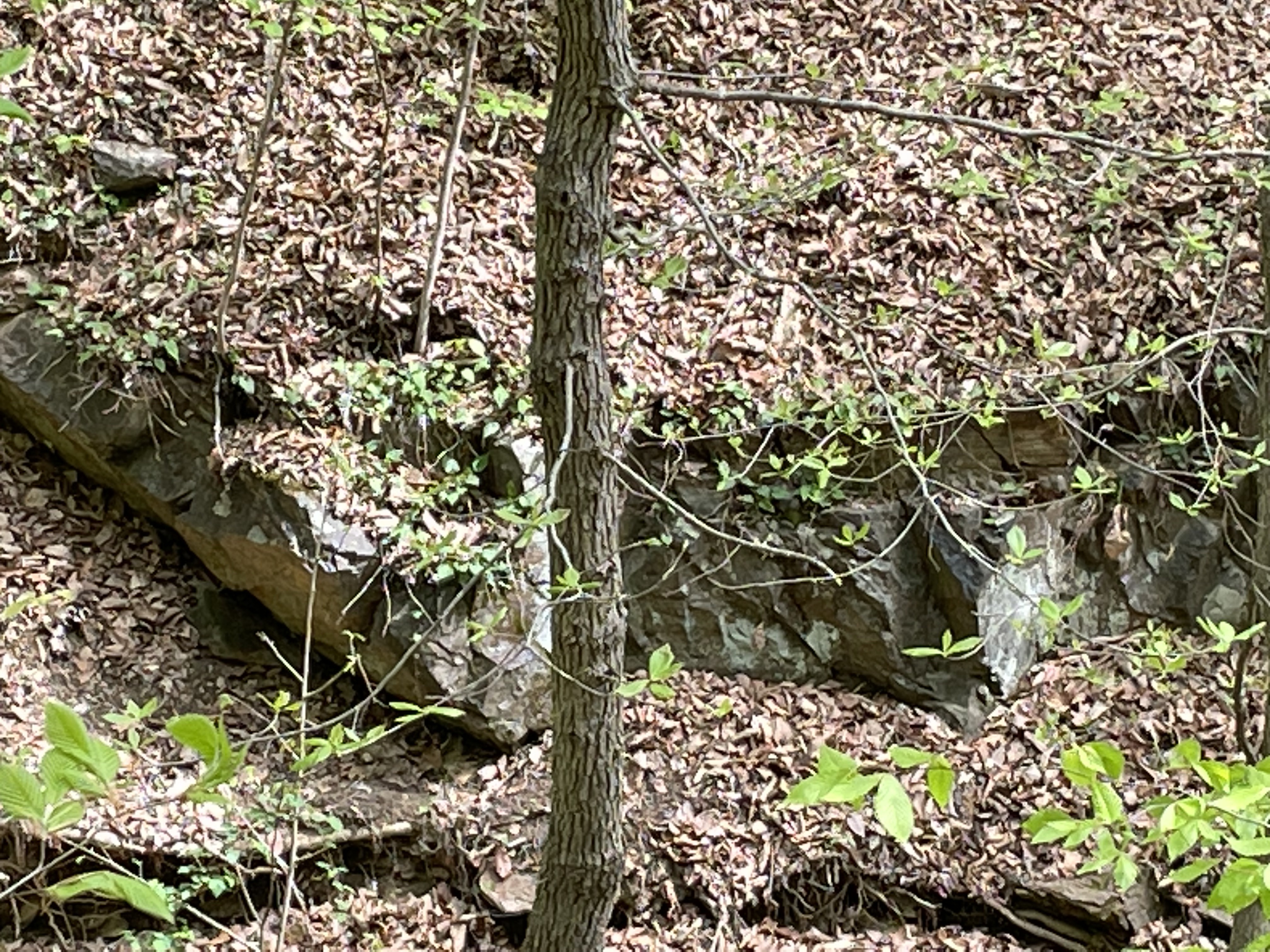
Plate 7. Photo looking north at an outcrop of the Jurassic diabase (age ~175 my) indicated in Plate 1, exposed by a stream that cuts across the Bull Run Fault. These are the youngest rocks within the region after rifting of Pangea had begun. Deeply buried rocks melt and some of the magma rises, following joints and weak lines in the overlying, solid rocks. Diabase, which has a composition similar to basalt, is formed like this although it often feeds volcanoes. The continental crust was stretched thin and fractured, allowing the diabase to work its way towards the surface. It only appears as lenses like those seen in Plate 2 in this area.

Plate 8. This image shows the typical growth for trees along the rocky crest of the hill seen in Plate 1. These large trees started out growing in fractures in the rock and, in some kind of enhanced biochemical and physical weathering, thrived and grew to be tall trees, probably almost a hundred years old. I’ve seen trees growing from large joints in rocks before, but never a forest that looks like it is set in concrete. There is absolutely no soil on these ridges but that didn’t stop Mother Nature.
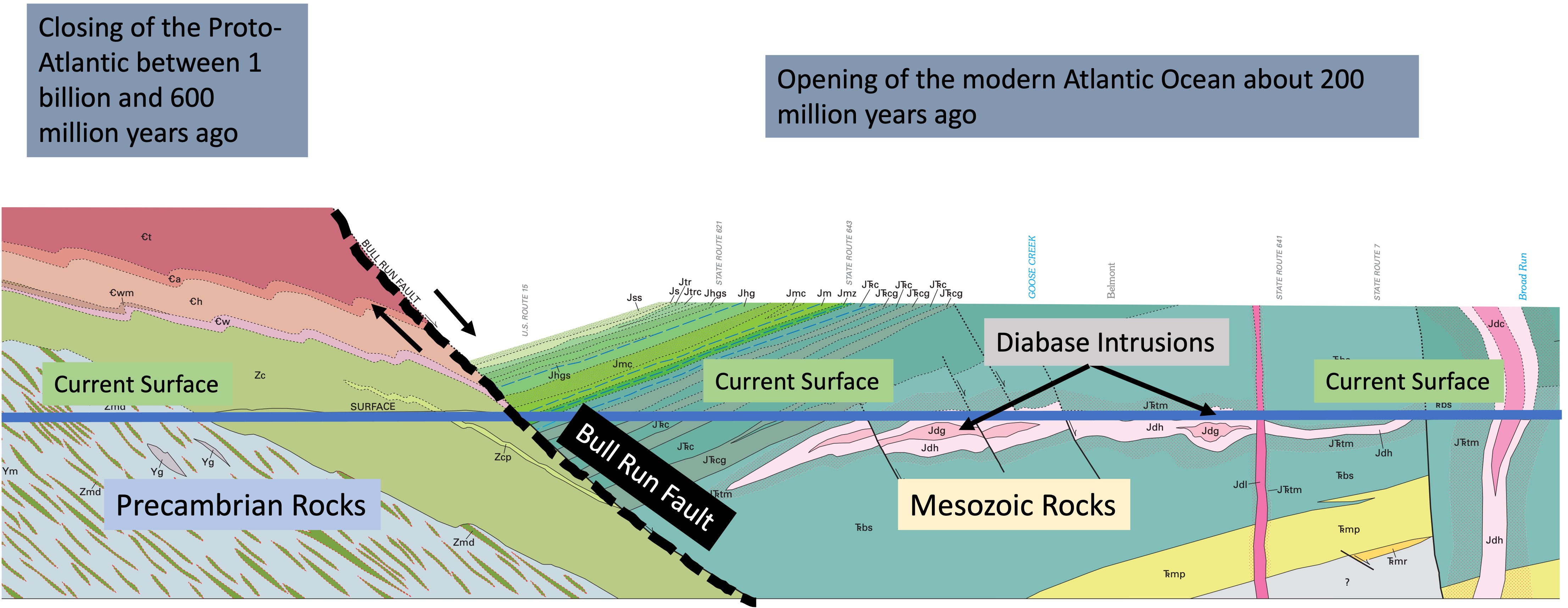
Plate 9. Cross-section across Loudon County, Virginia, from west to east. Bull Run Fault became active during the rifting of Pangea as the supercontinent stretched. The younger rocks on the east (right side of BRF) slipped down this fault surface, leaving the older rocks several thousand feet higher than where they belong stratigraphically (beneath the younger rocks). The arrows indicate the relative movement along BRF. The current erosional surface is indicated by the blue, horizontal line. This displacement has juxtaposed sedimentary and volcanic rocks that were created during the closing of an ocean basin (e.g. Plates 2-6), more than 600 my ago, with sedimentary and igneous rocks emplaced during the opening of another ocean basin, about 200 my ago (previous post ). The diabase intrusions (Plate 7) were emplaced during the latter event, cutting through rocks that weren’t much older than them (if you call 20 my a short time interval). The earth’s crust moves slowly over a semi-molten mantle, but it never stops moving back and forth; and the result is there to be seen if we’re looking for it.

Trackbacks / Pingbacks