
Review of “The Rise and Fall of the Neoliberal Order” by Gary Gerstle

I didn’t know what neoliberalism was until I read this book. Now, I understand its origins and why it isn’t even a new idea. The author does a great job explaining the political oscillations of American society in the last century in 432 pages, although the last 50 or so are references.
The grammar and punctuation are good, although some of the sentences ran a little long — when I forget what the subject is, that’s a little long. However, it was a lot better than another book I recently reviewed. The material completely supports the title and there are few, if any, divergences. It is well written.
There are thorough reviews available, so I’ll finish my review by saying that it was an easy read and I didn’t want it to end.
Horsepen Run in December
I wrote a post about streams traversing the Potomac River flood plain in a previous post. Horsepen Run is a meandering stream that has cut down several feet across the gently undulating sediments blanketing the mile-wide flood plain at this point on the Potomac (Fig. 1).
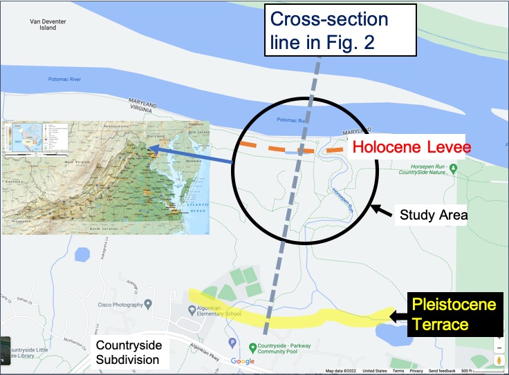
Figure 1. Map of Horsepen Run area. The reference to Fig. 2 is from the original post.
It had rained for 24 hours prior to this field trip, and then temperatures plummeted to well below freezing. It never snowed but there was some sleet. We are going to see some interesting features that resulted from this unique event. The watershed for Horsepen Run is rocky, with bed rock never more than a few feet beneath the surface, except on the floodplain (Fig. 1).

Figure 2. Shallow ditch along the path leading to the Potomac River, just entering the black-circled area in Fig. 1.
When I first came across the curious ice structures in Fig. 2, I thought someone had ridden a bicycle along the ice for fun. I didn’t figure it out until later.

Figure 3. Meander in Horsepen Run. The surface appears to be ice. Note the ice lying along the opposite shoreline. A curious structure.

Figure 4. The surface of Horsepen Run where it empties into the Potomac is solid ice. We tossed a branch out and it broke, indicating the ice is several inches thick.

Figure 5. Close-up of Horsepen Run at the Potomac. Note the broken ice about one inch thick lying along the opposite bank.
It’s time to put it all together. The water level during the steady rain was elevated so close to the stream’s outlet. The temperature was low enough (~10 F) to freeze the surface while water continued to flow beneath the ice. Even though the temperature remained very low, when the floodwater ran out from under the ice, it cracked and collapsed like a pane of glass. The newly exposed subsurface water at the lowered level then froze. This process occurred even in a few inches of water (Fig. 2).
The ice sheets (Figs. 4 and 5) serve as a high-water marker that melted away with the next thaw, serving as markers of how much water can collect during a light rain on nonporous soils and rock.
Geology integrates rock and soil with the atmosphere and hydrosphere into a holistic system that can surprise us at every change in the weather.

Recent Comments