
Multiple Faulting at Bull Run Nature Preserve
This post takes us a few miles south of Banshee Reeks Nature Preserve along Bull Run Fault. We’re going to see several faults and rocks that together represent the closing of Iapetus Ocean and opening of the Atlantic. This is a geologically complex area and my explanations will get speculative, but that’s what we do at Rocks and (no) Roads!

Figure 1. Geologic maps from the Rock D app, which I recommend to anyone with the slightest interest in geology. It shows the latest data, road maps, trails, your position, and descriptions of the rocks. It even has a Brunton compass tool. (A) Map of study area, which is less than 10 miles south of Banshee Reeks. As we discussed earlier, the pink rocks to the west of Bull Run Fault (BRF) are Proterozoic (between 1 billion and 538 million years old) whereas the blue shades are Jurassic (~200 – 145 my); the brown shades are Paleozoic rocks from the Cambrian period (~538 my). (B) Close-up map showing rocks and faults as follows: Zc = Proterozoic metamorphosed basalts with minor quartzite; Ch = Cambrian schists, phyllite, quartzite, conglomerate and siltstone; Cw = similar to Ch but dominated by quartzite; Jm = conglomerate, sandstone and siltstone interbedded. In addition to BRF another fault has been identified in the area, which I have tentatively identified as a Cambrian thrust fault (CTF).

Figure 2. The blue dot in the inset map shows the location of the images. This was a large boulder that is rounded from erosion but not finished (like for building houses); it is too big and heavy to be used for that purpose. The inset photo shows its pink hue with an irregular surface, suggesting that this is quartzite; I tentatively assign it to the Proterozoic rocks because the Catoctin Formation (Zc) contains marker beds of quartzite, and it is squarely within the previously mapped outcrop area of Zc.

Figure 3. Image looking at the bottom of interlayered siltstone and shale deposited about 538 my ago. A close-up of a loose boulder (inset) shows the characteristic sheen of phyllite as well as evidence of clasts, suggesting that this sample is a metamorphosed conglomerate. The Harper Formation includes schist lower in the section and conglomerate higher; schist is formed from mudstone whereas sandstone and siltstone, as well as conglomerate to some degree, don’t undergo significant changes in mineralogy at low metamorphic grade. Interbedded schist and quartzite implies rapid changes in either sea level or sediment source when these rocks were originally deposited.
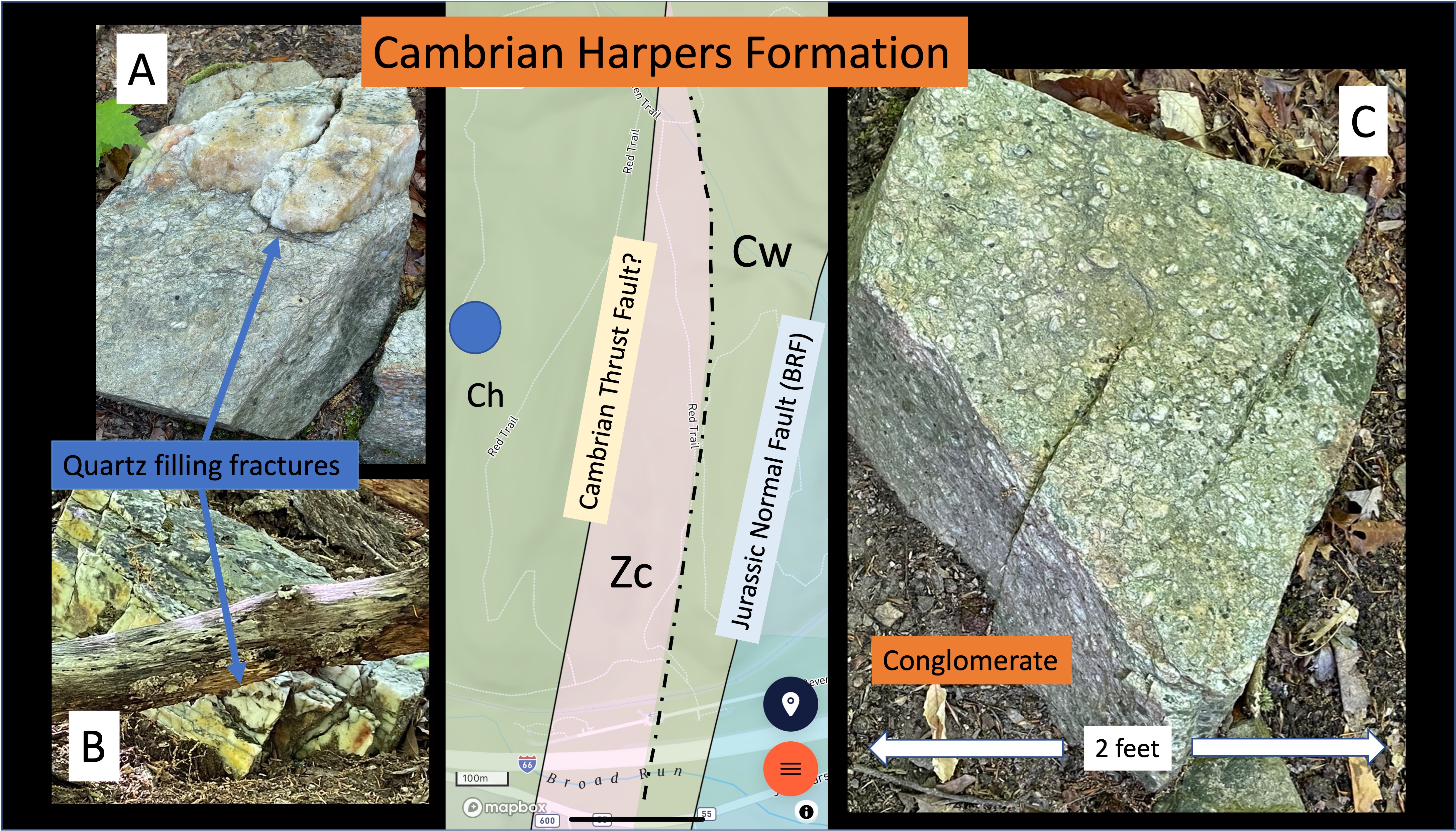
Figure 4. These photos of loose boulders were taken along a trail on a slope covered with soil (see inset map for location). (A) conglomerate with thick quartz deposit along a fracture, which would have been injected during deep burial and metamorphosis, probably originating from interbedded shale; which became schist. (B) Vein containing white (quartz) and yellow minerals along with a black band; the latter two minerals could be stains in the quartz or something else. (C) Good example of conglomerate, showing rounded pebbles less than one inch in diameter in a fine matrix. These rocks are similar to the inset photo in Fig. 3 but reveal less schistose banding, probably because of a higher quartz content in the matrix.
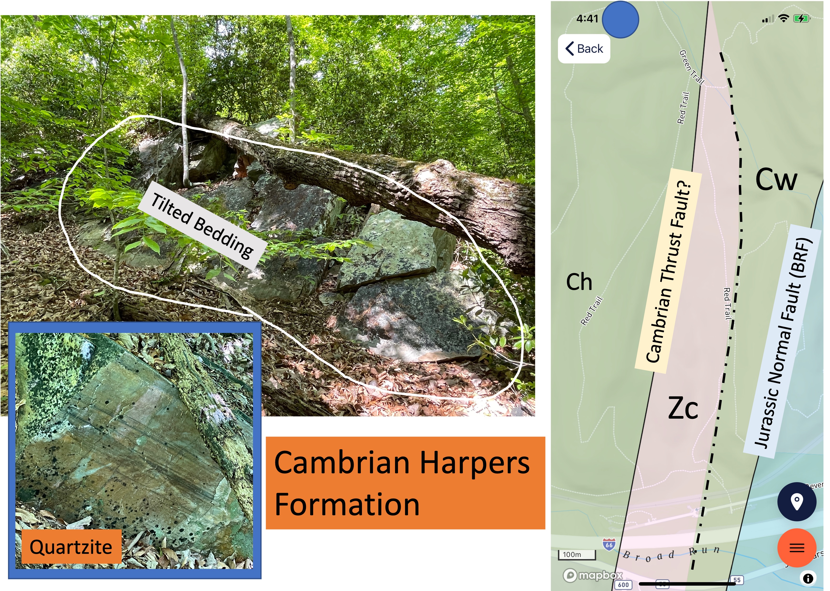
Figure 5. Excellent exposures of the Harpers Formation were found at the northern end of the study area (see index map for location), where beds were tilted about 30 degrees to the east. There were also large blocks more than six-feet across that were horizontal (not shown). They were too large to have been placed there without substantial effort, so my best guess is that they were resistant to erosion and dropped down as easily eroded layers were removed beneath them; that sounds like a flimsy explanation but they were not attached to the tilted beds in this photo. The inset shows bedding in the quartzite (in place) that suggests deposition in a river because there is no evidence of cross-bedding (i.e. wave action). However, the thin laminae (dark lines) suggest a quiet environment, possibly a delta.
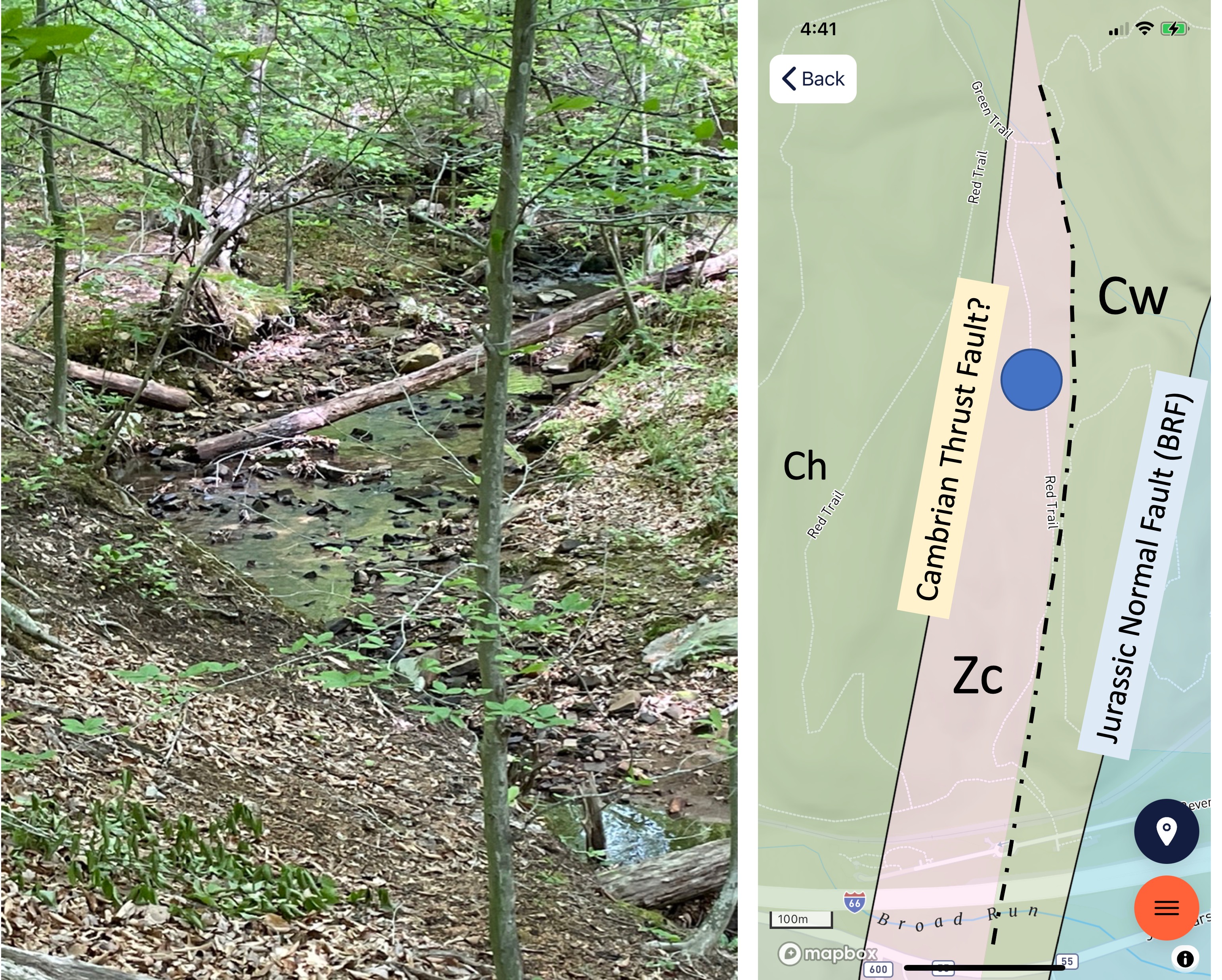
Figure 6. Sometimes you can recognize rocks by their absence. This photo was taken within the metamorphosed basalts of the Catoctin Formation (Zc in inset map), which weather rapidly compared to quartzite and even schist. The entire area shown as Zc in the inset map formed a broad, flat, shallow valley with a stream meandering through it. All of the rocks I saw along the stream were quartzite eroded from the surrounding ridges. The contact between the older rocks (Zc) and the younger ones (Cw) cannot be ascertained in this area because we didn’t find any Catoctin Formation rocks in place to check their orientation. The contact is therefore shown as a dot-dash line; the Cambrian rocks may have been deposited directly on the Proterozoic sediments, or after a period of erosion (disconformity), possibly even after deformation (angular unconformity).

Figure 7. Along the eastern side of the study area we encountered the BRF, which juxtaposed Jurassic conglomerate against Cambrian quartzite, forming an outcrop consisting of large protrusions of bedrock. As can be seen in the background of this photo, a steep slope fronted the outcrop. The bedding in the inset photo suggests that they are dipping to the west, opposite of the older rocks seen in Figs. 3 and 5. These conglomerates were probably deposited after BRF began to move but before faulting ceased, tilting them as they slid down BRF, which is a normal fault.

Figure 8. Schematic thrust fault zone, showing layers (blue) sliding along low-angle reverse faults over time, from top to bottom. We can apply this model to Bull Run Nature Preserve by first reversing the image left-to-right; the blue rocks represent Proterozoic rocks (Zc) deposited between 1 by and 538 my ago; the green representsCambrian rocks (Ch and Cw) deposited between 538 and 511 my ago. This is the only physical mechanism that can explain the presence of Zc east of Ch in the geologic maps. Note the resulting tilt of the rock layers after being thrust over younger rocks; the tilt away from the fault. This is consistent with what we see in Figs. 3 and 5.
Summary. Beginning about one-billion years (by) ago, the Iapetus Ocean began to close, ringed by subduction zones on the east and west. As the distance between proto-North America and proto-Europe shortened, magma began to form within the deepest parts of the crust that was being subducted. Volcanism ensued and, for hundreds of millions of years, this continued; igneous and volcanic rocks formed the Catoctin Formation (Zc in the maps).
As the Cambrian period began about 540 my ago, sandy sediments were deposited on top of this pile of ancient rocks. This huge pile of rock of all types was jammed into proto-Europe and buckled (see Fig. 8), sliding older rocks over younger and forming an overthrust belt, all of this occurring deep beneath a mountain chain as high as the Himalayas. We have seen the roots of these mountains in a previous post.
This collision ceased when the resistance of so many rocks with nowhere else to go overcame the forcing mechanism; wind, water, and ice went to work, eroding these mountains for almost 300 million years. By then what had been deeply buried (e.g. Zc and Ch) was exhumed, exposed to the atmosphere and ocean.
In a magical dance that geologists call “upper mantle processes”, the supercontinent, Pangea, was torn apart along the same suture that had created it from two smaller continents. Bull Run Fault was near the western margin of this rift zone. Conglomerate was deposited within the rapidly subsiding basins formed by this crustal stretching (e.g. Jm). Just as with the collisional cycle that preceded rifting, sedimentation and structural deformation occurred at the same time. Thus the Jurassic conglomerates we saw in Fig. 7 were tilted to the west as they slid into a graben. For the next 200 million years, they sank into the earth as the rift zone cooled, along with Proterozoic and Cambrian rocks (e.g. Zc, Ch, Cw), and waited for isostasy to bring them back to the surface.
This post has awkwardly played a few notes of a symphony that lasted a billion years.
It’s all there in the rocks …

Trackbacks / Pingbacks