
Review of “Even Cowgirls Get the Blues,” by Tom Robbins

I focus on writing style rather than story in my reviews. It’s important to understand the difference because I didn’t enjoy any of the books I’ve read as part of my reading comprehension hobby. Like everybody else, I know what I like to read and I avoid reading those books. In case I’m sounding a little masochistic, let me add that I write my favorite novels rather than read them. I guess I’m narcissistic. Writing is a lot more fun than reading my favorite genres because it takes months rather than days. However, I have spent months reading some of these books. This one took more than a month to finish.
First, this book is well written, which means that it has few blatant grammatical or punctuation errors. So, it was relatively easy to read.
This book was published in 1976 and its pedigree is obvious in every page. About half the book consists of monologues by the author, sometimes thinly disguised as the words of the characters. These come in two types. The first is a summary of the first year of college. No subject is skipped, from geology to business. This was written when an encyclopedia was the best source of information and that’s how it reads. I checked a lot of the facts and they were accurate, especially for the time. The second kind of monologue consists of political and social diatribes, covering the gamut from the environment to women’s rights. This category also includes goofy ramblings on transcendental topics. Most of these diatribes are on subjects completely outside the scope of the story, which brings me to the story.
There is a story buried in all those regurgitations of Geology 101, Philosophy 101, Biology 101, etcetera, but it isn’t much. The story of Sissy Hankshaw is at most a novella. And don’t believe anything written about this book by reviewers, especially what’s printed on the back cover. Until I read this, I thought there was some kind of unspoken oath to be honest in the publication industry. No, there is not. The author spends so much time remembering (sometimes fondly) his college days, that he never got around to writing a novel.
The central character is a paper cut out, who periodically changes to a different person with no explanation, other than self-serving nonsense muttered by the author during frequent interludes. This is a cartoon disguised as a novel. It doesn’t even qualify as social satire because the author simply rants against his pet peeves, rather than presenting them within the context of a story.
For example, when the author realized he’d gotten carried away with some scenes that were special to him and presented them out of chronological order, he bragged about his error and, to prove who was smarter than us (we’d bought his book and given him money), ranted about the power he had over the reader. At another point, he went on a page-long tirade about sentences. These interruptions were continuous.
I don’t think any of the reviewers whose glowing comments I read, actually finished this book. My certainty of this was verified when I read the plot summary on Wikipedia. Wow! That’s not the book I read word after excruciating word.
This book is the worst I’ve read in my reading comprehension study, even below the Koran. It has no redeeming qualities. I can only hold it up as an example of a meme in the pre-digital age. Reading monkeys don’t actually read, but they like to pretend they do.
As a bonus, I was going to review the movie, but I couldn’t see it here in Australia. It wouldn’t play. The best I could do was see a 15 minute summary, using original film marked up to support the author’s faux-feminist concepts (my interpretation). Looking beyond the magic marker comments, I think the casting was excellent. It may have been a good movie, although it definitely varied widely from the novel. The movie outtakes I saw didn’t start until the second half of the book, and the male romantic lead never showed up, not even being listed in the credits. I don’t know if the many diversions are in the movie. I may watch it someday, just because I’m stubborn.
If I weren’t too lazy, I would tear every page out of this book, burn them, and spread the ashes in the ocean, so that no one else would have to read it.
It’s that bad, but this is only my humble opinion, as one of two or three people who read it cover to cover. (I don’t think the author was one of them.)
Zombies Revisited
In the last post, I examined the usefulness of the Zombie metaphor as a proxy for consciousness. I think I demonstrated that it depends on the definition of consciousness one chooses. The Idealists and Physicalists are using different definitions but won’t budge on their semantic representations.
It seems clear to me that the Physicalists win the first round of the fight because they can show with empirical evidence that consciousness resides within the brain and is associated with distinct electrical and chemical signatures. That doesn’t mean they’re right about everything, however, because as I said, that only means that consciousness is manifested as a physical process.

This is not what I’m talking about.
I’m going to examine the Idealist view of consciousness briefly, and what it suggests about reality, and what it means to be a zombie. Idealism represents two overlapping views of reality that share the central concept of subjective reality as opposed to the physicalist view of objective reality. Subjective Idealism, as the name implies, posits that reality is a subjective experience, unique to every conscious entity in the universe. Objective Idealism, on the other hand, proposes that there is an objective consciousness that somehow is the core of reality, independently of a human mind. This sounds a lot like some religions to me.
Reality is an illusion from the subjective perspective; however, it is a personal experience, not supplied by an external source like a god or the cosmos. I am the center of the universe, even if my illusion puts me in the worst situation imaginable. Talk about making bad choices.
Am I a zombie?
According to the subjective view, I am not a zombie, but YOU are and vice versa. I can’t help but take this thought experiment (I can’t really treat it as a serious model of reality) to the next level and ask: Does this mean that I’m the only person in my universe? A real person I mean: a non-zombie. The question of agency arises, at least in my mind. If I’m the only person in my world, why don’t I make myself happy and fulfilled, whatever that entails? Why am I not wealthy? Where are my awards and prizes, and all that money?
I don’t have to be a philosopher to answer that question. I’d give the same answer as all the religions that have ever existed: You are a god (maybe God?) and you work in mysterious ways. This is what you really need, or you’re dealing with something more important that has nothing to do with the plane of reality where you’re reading this, and living this life. Of course, the successful might have gotten it right and be living–never mind, they’re nothing but zombies in my world. It’s pretty lonely here.
If the objective idealist viewpoint is correct, we are all zombies. This isn’t as crazy as it sounds, the way I worded it. To the cosmic consciousness, we are zombies, unconscious entities who stumble around, running into each other, unaware of the Big Picture. That’s a pretty accurate image of the world. Remember that we have empirical evidence (for whatever that’s worth in the objective idealist universe) for consciousness, and my thought experiment from the last post. In this view, I am an ephemeral entity, created by some great, cosmic consciousness for their own amusement but, even though I’m a zombie, I have a sense of being alive because my brain (whether real or not) perceives. This world kind of sucks too. We’re all zombies and nothing we do matters, not to us anyway.
I can understand the popularity of the Physicalist’s perspective after giving the subject some thought. Who cares if I’m a figment of my imagination or the cosmic consciousness? I’m stuck here dealing with what seems pretty real to me, so I may as well accept the fact that I’m really living this life. The down side to this perspective is that there is no hereafter: no heaven, but no hell either (that’s a nice idea), but only oblivion just like the birds, bees, fish, trees, rocks, earth, sun, universe.
That’s not so sweet either.
I don’t know if this brief discussion satisfies you, but it’s sufficient to keep me happy for a few months.
After all, the great cosmic consciousness wants me to be happy.
Am I a Zombie?
Subjective Idealism posits that nothing exists unless it is perceived. A cornerstone of this philosophy is the existence of consciousness, a phenomenon that isn’t required by physicalism. From a physicalist perspective, if it walks like a human, talks like a human, and acts like a human, it’s a human, whether conscious or not. The idealist doesn’t accept this, claiming that consciousness is the key to being human and without it the physicalist’s human is nothing more than a zombie. They use some sketchy logic to prove that the physicalist argument is wrong, that there is no objective material world of which everything, including consciousness, is part of. Hence the title of this post.
The gist of the argument is this: everything in the world is physical; physicalism predicts the existence of a parallel universe that is exactly the same as ours, but lacking consciousness [because it is not physical]; imagine a world full of unconscious zombies (if you can imagine it, it’s possible); thus physicalism is false by a logical method called modus tollens.
I find the assumption that consciousness is not a physical phenomenon somewhat self-serving and don’t accept it. I don’t think it convinces Physicalists either, but this introduces an intriguing idea, one I’ve been exploring in my Dao De Jing blog. I don’t think the philosophers took the zombie world thought experiment far enough.
Let’s begin with my a hypothetical question: What would it be like to be a zombie?
I have my own thought experiment to address this, without using the word, consciousness, which the philosophers appear to be hung up on.
Imagine a day like this: you get dressed, have breakfast, and go to work, recalling a movie you watched the night before, so that you don’t recall the commute; you have a lot of busywork to do, forms to fill out and mindless emails to answer; your work day is interrupted by lunch with some coworkers talking about their new house, which they’ve been describing all week; you don’t recall the unmemorable drive home and make a dinner you’ve prepared a thousand times, talking to your family about school and other familiar topics; you clean the kitchen and watch TV until bedtime.
Question: Did you ever engage your prefrontal cortex in complex problem solving, analysis, or making plans? Remember this is a thought experiment, so brief interludes of thinking about a nagging problem don’t occur. This day was successfully traversed using only heuristic memory, your automatic behavior modified slightly using Bayesian estimation. This is a technique built into our cerebellum and thus requiring no active thinking.
Are you a zombie?
Of course, I did the same as the philosophers, switching the definition of consciousness without telling you. My story defines consciousness as being aware (as in I AM AWARE thinking) of what you are doing. But if you can’t recall the drive to work immediately afterward, were you conscious of it? Considering the rest of this boring day, in which your mind basked in the afterglow of a movie you loved (an emotional response stimulated by memory), were you ever really conscious?
It seems to me, therefore, that the concept of a zombie world is an axiom rather than a thought experiment intended to show that Idealists are more clever than Physicalists. Such a world does exist, only not as a homogeneous universe filled with permanent zombies. We are all zombies, unconscious beings who walk, talk, act, and behave like humans much of the time.
The only prerequisite to being a zombie appears to be that the entity is unconscious. Zombies have brains with neurons, axons, and electrical signals flashing to and fro within their gray matter. Hormones are secreted by their limbic system. They have emotions. They are human. But they are also zombies, just not all the time.
I’d like to add a word on the sophistry of these arguments. There is overwhelming empirical data that demonstrates the neurological manifestation of consciousness. The brain reveals conscious acts through electrical activity. Thus, even if there is something vague called universal consciousness as proposed by Objective Idealism and there is a mind-body dualism, this unknown entity, whether physical or metaphysical, functions through the brain to create consciousness. It seems inescapable therefore that consciousness exists in the physical world as a concrete, measurable process–a process that acts on matter even if not itself a material substance.
Next time, I’ll discuss another interpretation of the zombie concept, this time with a decidedly more idealist perspective.
What Did We Expect?
Who knows what the New Colussus is? I certainly didn’t remember, although I’m certain that I heard about it at some point in my life, maybe high school civics class. Here it is in its entirety:
The New Colossus
Not like the brazen giant of Greek fame,
With conquering limbs astride from land to land;
Here at our sea-washed, sunset gates shall stand
A mighty woman with a torch, whose flame
Is the imprisoned lightning, and her name
Mother of Exiles. From her beacon-hand
Glows world-wide welcome; her mild eyes command
The air-bridged harbor that twin cities frame.
“Keep, ancient lands, your storied pomp!” cries she
With silent lips. “Give me your tired, your poor,
Your huddled masses yearning to breathe free,
The wretched refuse of your teeming shore.
Send these, the homeless, tempest-tost to me,
I lift my lamp beside the golden door!”
Emma Lazarus
November 2, 1883
Now I bet you recognize it, especially the last quote from the Colossus: “Give me…the wretched refuse from your teeming shore…the homeless…” This is a very nice sentiment, encapsulating the origins of so many people arriving in North America, beginning with religious zealots persecuted for their beliefs; and uneducated men and women (not needed by the pre-industrial societies of the time) signing contracts to work as indentured servants for years, arriving in the swamps of Virginia.
Naturally, they carried the memory of their previous lives into the new nation they eventually formed. I recommend a recent book called Fantasyland, by Kurt Anderson to better understand these people, the people who formed the character of America.
There’s a reason the Colossus voices her invitation. The colonists and most subsequent immigrants to America were misfits with nothing to lose. Even the wealthiest, who became the Founding Fathers, were antiauthoritarian rabble rousers who resented any power greater than their own, especially the southern slaveholders.
These personality traits became cemented in the character of every colony, later state, and then the United States. I’m not saying that a different group of colonists and immigrants wouldn’t have done the things these people did: murdering Native Americans and stealing their land; enslaving Africans kidnapped from their homes; decimating the environment, leaving scorched earth in their wake; and turning against their own government (the British Crown) over what were actually pretty minor offenses, as government’s behaved back then.
What did we think was going to happen when a national character born from fear, desperation, persecution, and superstition–reinforced by 200 years of “wretched refuse” arriving in droves–faced a challenge? Every crisis, usually of our own doing, is an opportunity to blame someone else, preferably a newer arrival.
In the words of Britney Spears, “Oops!…[we] did it again.”
Geology of Australia: a Summary
This post is going to summarize everything I’ve learned about Australia from all my field trips so far. The first section, presents our last field site in the Australian Capital Territory, however, before summarizing the geology of the ACT, Queensland, Victoria, and Tasmania.
Tertiary Sediments
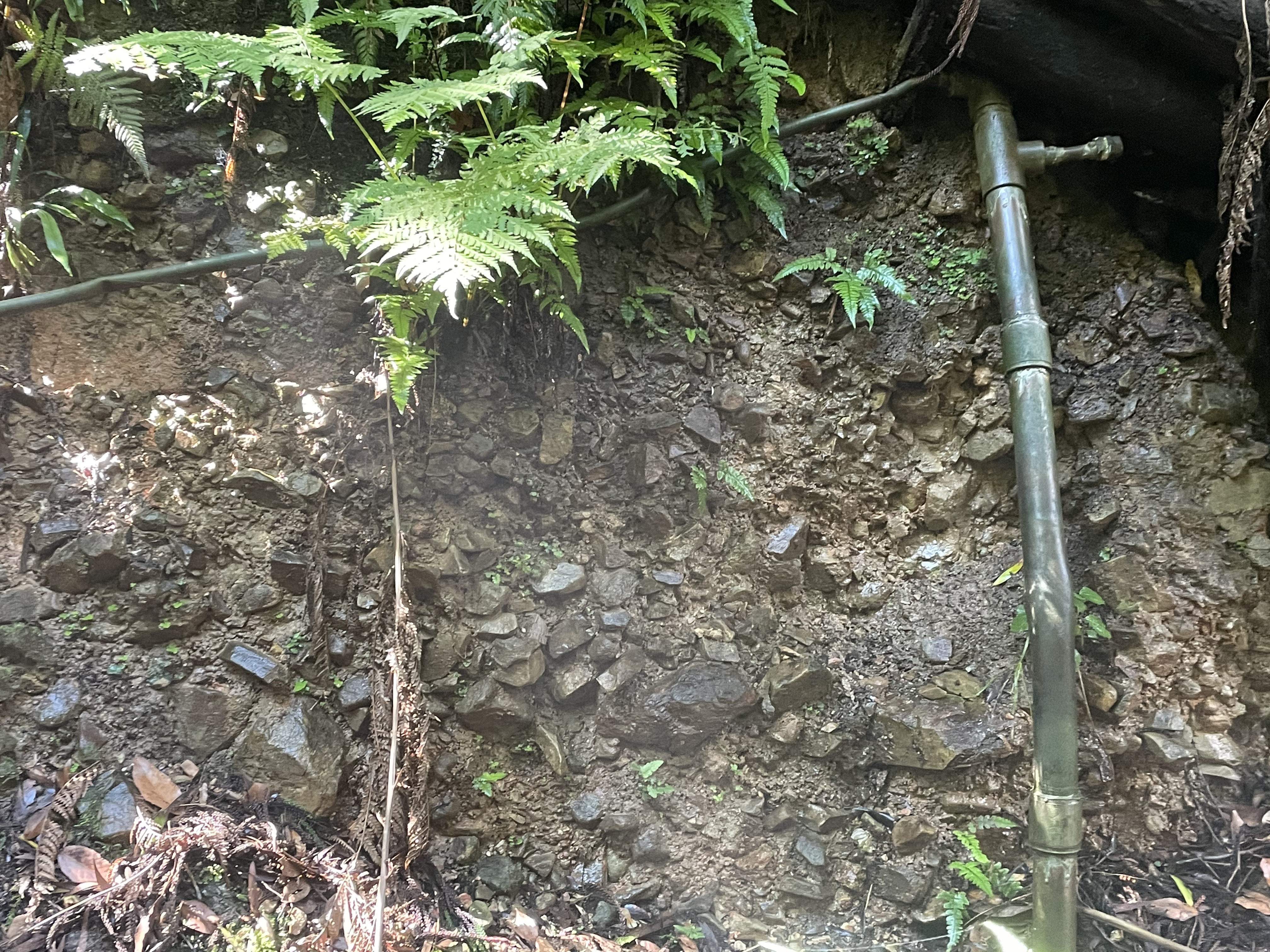
This is the last post from the ACT. Site 31 (see Fig. 1 for location) is located in the Botanical Garden, where a gully was excavated to create a rainforest. Despite the low rainfall in the area, it worked and a path leads through what appears to be an erosional gully from Queensland.
 Fig. 1
The fanglomerates exposed by the excavation haven’t been dated but are believed to be 2-3 million years old. This is too old for carbon-14 and too young for other radiometric techniques. Apparently, they don’t contain sufficient fossils to date either. These rounded cobbles of all sizes (Fig. 2) were deposited on an alluvial fan (hence the name) near steep mountains.
Fig. 2
 A
A  B
B
 C
C
The cobbles range in size from ~one foot in diameter to less than an inch. Such a disparity is size results from short transport distance from the source, but the rounded shape of many of the cobbles suggests that transport in steep and rapidly flowing streams before deposition.
ACT Summary
Most of the rocks we’ve seen in the ACT were deposited/intruded/extruded between 485 and 400 million years ago. The oldest rocks were originally deposited in an ocean trench near rapidly rising land with volcanoes erupting periodically, someplace like Japan today. Sedimentation accompanied by granite plutons pushing into older rocks as well as explosive volcanism continued throughout this interval. Sometime after ~420 Ma, many of the older rocks were buried and subsequently folded during a major compressional tectonic event. All of this occurred within a relatively small area, but over an immense time interval.
Whatever event created the mountains that must have existed ended and erosion began. Erosion of this immense mountain range continued for almost 400 million years, at which time the remnant mountains were still large enough to have active alluvial fans between 2-3 Ma.
Events in Queensland
We can fill in some of the gaps from the ACT by reviewing our trip to Brisbane.
First, Sand and mud were collecting in a shallow marine environment between 383-323 Ma, less than 600 miles NE of Canberra. These sediments were deeply buried, deformed, and slightly metamorphosed sometime after deposition. Volcanism was occurring as well.
Between 237 and 200 Ma, sand and mud were being deposited in a delta environment with enough organic matter collecting to form commercially viable coal beds. During this same period, massive layers (>300 feet) of rhyolite were ejected from a shallow magma chamber, forming one of the largest calderas in the world. Erosion ensued until 23-16 Ma, when basalt flowed over the Brisbane area. (Note the change from felsic to basic volcanism during this geologically brief time span.)
Changes in sea level are currently leaving a record in beach sediments that may someday become rocks.
Events in Tasmania
Sedimentary rocks were collecting in Tasmania (~600 miles to the south) between 1600 and 540 Ma. Volcanism was also occurring during this interval, recording a mountain building event not that different from that which occurred later. In fact, the dates are close enough (540 Ma here versus 485 Ma in Canberra) to justify calling this a continuous orogeny. Slightly later (500-470 Ma), a coastline was present in central Tasmania, and intermediate-to-felsic volcanic rocks were produced when a large granitic pluton was emplaced into older sedimentary rocks. More granite was emplaced between 420-360 Ma.
To get an idea of what might have been happening over such a long time (~1600-350 Ma), imagine all the islands east of Australia (preferably viewed on a globe) colliding with it, being swallowed beneath the much more massive land mass. Finally, picture Australia colliding with South America about 350 million years ago. It was that massive an event. Faults and folds are everywhere.
Between 252-201 Ma, Tasmania was collecting rocks in lakes and rivers, i.e., terrestrial sediments. There was also some alkali volcanism occurring. This period didn’t last long, however, being followed (201 and 145 Ma) by the emplacement of a huge basic intrusion close to the surface, between layers of sedimentary rock (aka laccolith).
Basalts flows spilled out of multiple volcanos around 60 Ma. Gravels and sandy sediment collected after ~2 Ma and the current surface is eroding as the land rebounds from removal of miles of sediments.
Summary of Victoria
Melbourne was part of a massive delta system during the Ordovician period (~490-440 Ma), at the same time that so much was happening ~400 miles to the north, in the ACT. These rocks were later folded. Sedimentation shifted to sandy during the Silurian period (~440-416 Ma), probably due to a river changing course. Sometime after 440 Ma, regional compression changed from SE-NW to SW-NE, and increased in intensity.
During the Cretaceous period (145-65 Ma), clastic marine sediments were collecting, as well as nonmarine. Sea level was oscillating. No radiometric dates are available.
The SE tip of Australia was covered by a massive volcanic field after 65 Ma. These flows reached the ocean and extended offshore. Some ash layer were created as well. Nonmarine sediments were also collecting during this period, but they weren’t buried deep enough to become hard.
Between 10 and 5 Ma, the Melbourne area changed from a shallow marine/deltaic environment to an arid land, with episodic sedimentation in streams. Basalt flows continued to pour onto the land, until 700 thousand years ago. During the last million years or so, the climate has dried and most rivers don’t reach the coast, leaving relict sands scattered over older rocks exposed at the coast. Cliffs are common features, partly because of sea level change, partly because of isostatic rebound.
That’s it so far. I’ll update the summary as the field data accumulate.
Australian Capital Territory: Orogenic Volcanism
As I’ve been discussing in the last few posts, the rocks of the ACT record a mountain-building episode between about 485 and 400 million years ago. This post is going to examine some volcanic rocks extruded towards the end of this period.
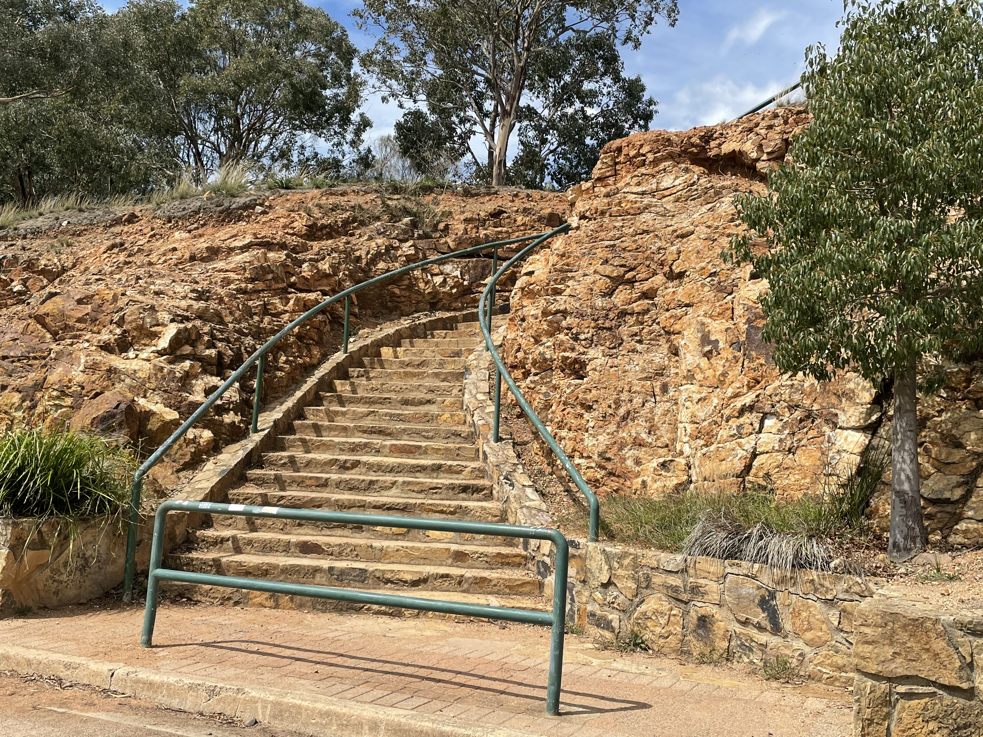
We drove to the top of Mount Ainsley, Site 16 from the regional guide (See an earlier post for details), from where we looked down on Canberra (Fig. 1), standing on top of a stack of mostly volcanic rocks extruded between 433 and 427 Ma, towards the end of the orogeny. The top of the mountain is approximately 800 feet above the base, which also reveals outcrops of the Mount Ainsley Volcanics formation. That is a thick pile of volcanic material deposited over a 6 million-year interval.
Fig. 1
 A
A  B
B
However, as we’ve learned before, geological time is long. For example, (using SI units for convenience), the mean extrusion rate is 250 m/6 million years, or 40 cm/1000 years. The number is simply too small to comprehend as an annual rate. This is a good rate, however, because it suggests that on average about 40 cm (16 inches) was extruded from a nearby volcano every 1000 years. So it wasn’t as if hell was raining down daily. Let’s see how our estimate compares to the rocks.
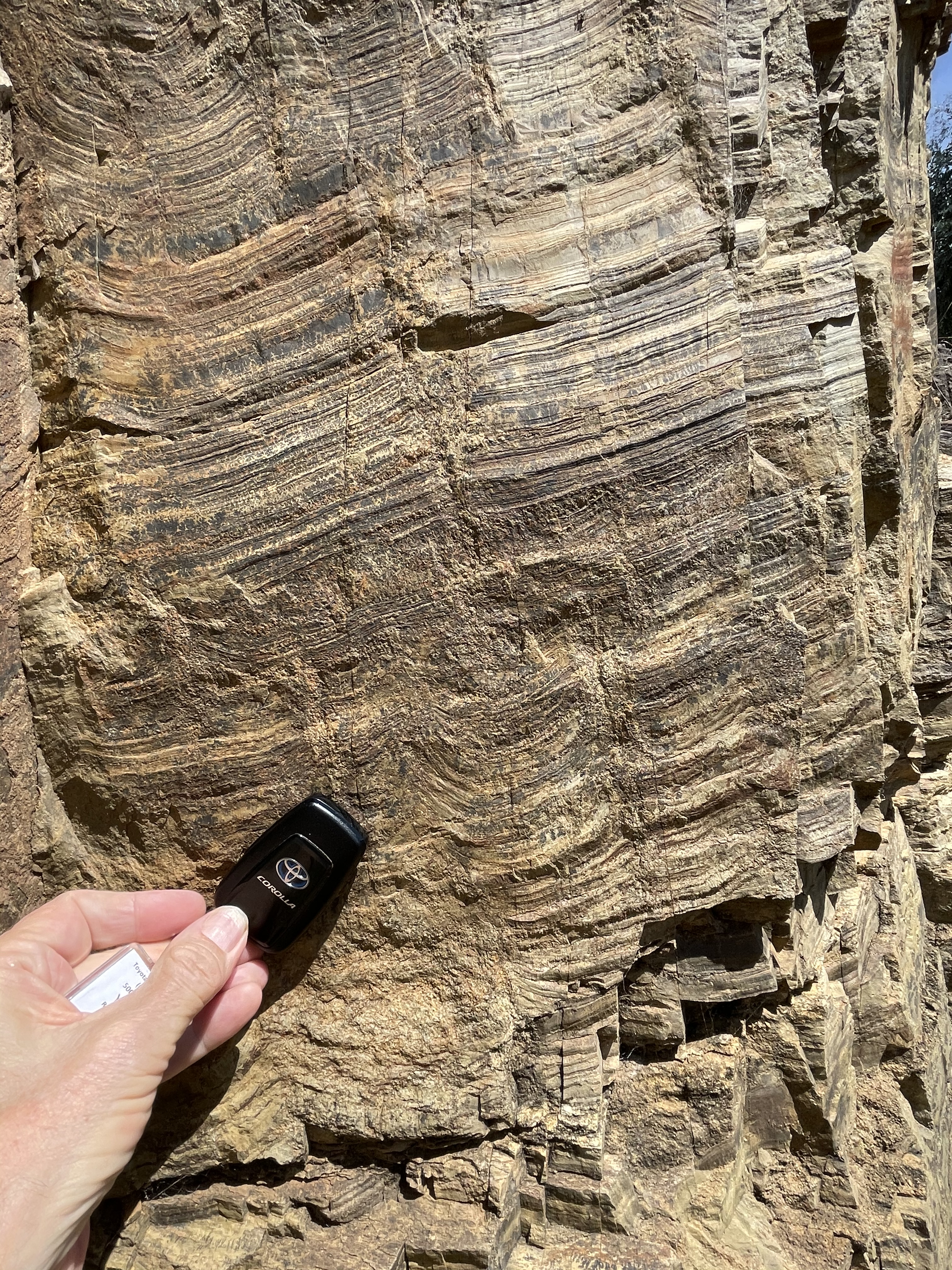
We’ll start at the highest point on Mount Ainsley. It’s typical for volcanic rocks to look like they have bedding because they are often produced in episodes and thus form layers, but they aren’t deposited by water so they don’t have well developed layers. That’s what we see in Fig. 2
Fig. 2
 A
A  B
B
 C
C  D
D
Figure 2A shows a well-preserved face, and this irregular bedding as well as some fractures are visible. A close-up (Fig. 2B) shows a gray rock, varying from lighter to darker shades. There is some irregularity in the coloration on this relatively fresh surface and xenoliths (pieces of rock) and phenocrysts (minerals) are visible as lighter color blebs and very small particles in panel B. The variability of the deposit is obvious in Fig. 2C. The left side of the steps is thinly bedded whereas thick layers are visible to the right. In fact, Fig. 2D (taken on the other side of the knob that defines the highest point of Mount Ainsley), shows massive, rounded appearance.
The only way to identify individual volcanic deposits is if enough time passes between them for the surface to weather. That isn’t obvious here and there was no mention of it in the guidebook. Thus, it’s possible that Fig. 2 represents a single episode, or many scattered over decades or centuries.
Massive layers are exposed in road cuts as we head down the mountain (Fig. 3), through the thick section of volcanics.
Fig. 3
 A
A  B
B
Figure 3A is featureless but panel B reveals a different texture in the middle of the photo, as if the material was fractured before it cooled, giving it an irregular appearance.
I haven’t mentioned what kind of volcanic rock this is. First, it’s gray color is intermediate between darker volcanics (e.g., andesite) and rhyolite, which is very light gray. The guidebook identifies this as dacite, which is in fact intermediate between the two. Dacite consists primarily of quartz (gray material in photos) and plagioclase feldspar (white material). Some of the 800 feet of volcanics was probably extruded as a thick substance because magma with lots of quartz tends to be thicker than low-silica melts. However, these magmas also tend to be explosive (remember Mt. St. Helens), trapped gasses being released catastrophically.
At the bottom of Mount Ainsley, we went to Site 26, where blocks of agglomerate are exposed in a small area (Fig. 4).
 Fig. 4
These boulders are in place, being the tips of a larger outcrop covered by the thin soil. A piece broken off by a previous visitor was waiting for me (Fig. 5A). I didn’t have to touch it. Note that we are now at the bottom of the mountain, somewhere near the bottom of the pile of volcanic material. These rocks are certainly thousands, if not millions, of years older than those in Fig. 2.
Fig. 5
 A
A  B
B
The sample in Fig. 5A is 18 inches long. The lighter areas are either pieces of country rock, or feldspar (which crystallizes at a higher temperature than quartz). Figure 5B is close enough to see the wide range in the size and shape of the phenocrysts (the image is ~5 inches across).
I’m going to take a moment and look at this rock (not the same sample) even closer (Fig. 6).
Fig. 6
 A
A  B
B
 C
C
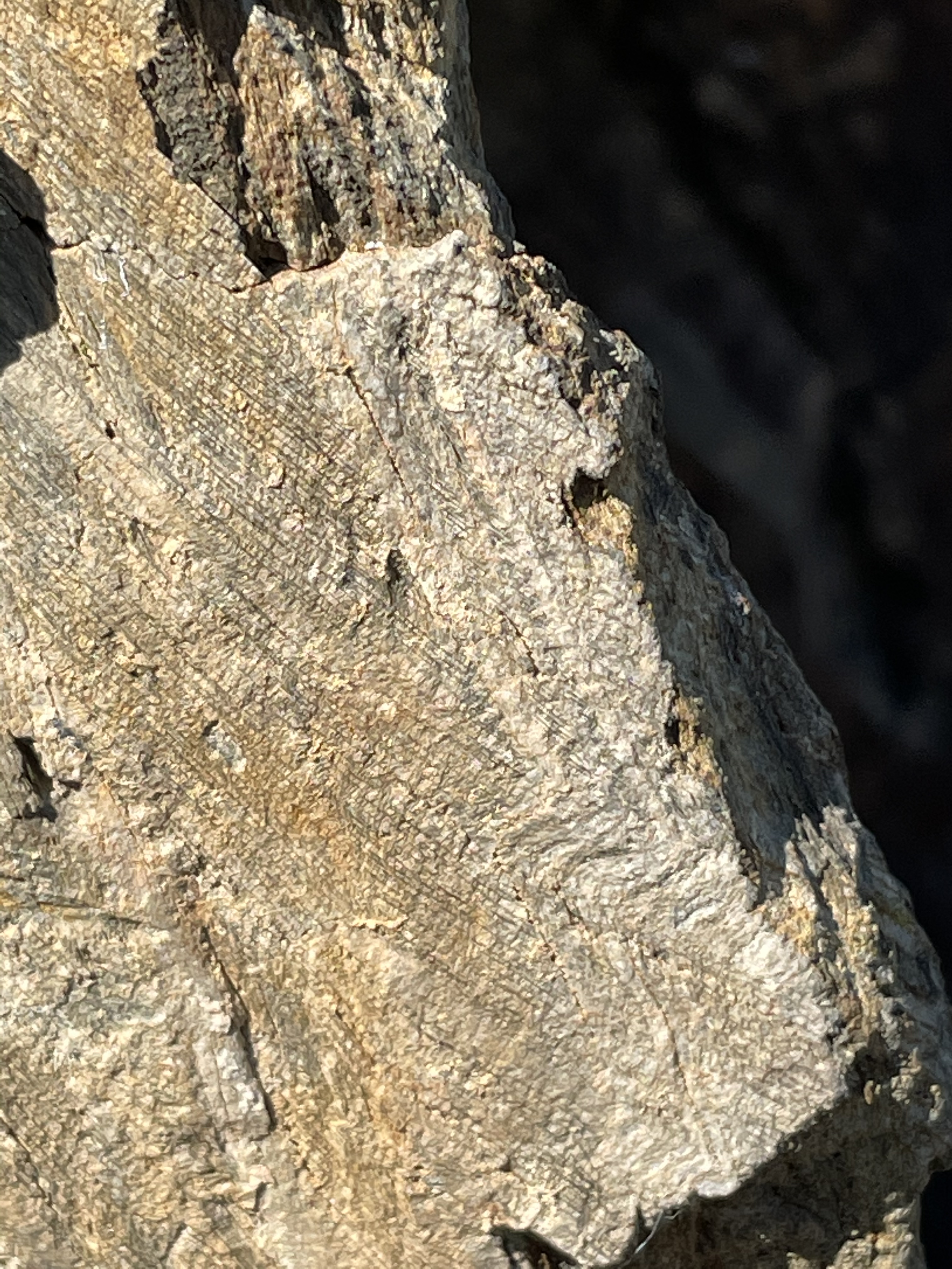
Figure 6A is about 3 inches across, and individual phenocrysts can be identified, including both white (feldspar) and black (unknown) minerals. Zooming in on the photo, the crystallization of the phenocrysts is clear, and even the dark gray groundmass takes on an irregular shape, no longer appearing uniform.
Figure 6B is at even higher magnification. It shows the edge of one of the white phenocrysts against the matrix. The contact is not as sharp as one would expect if it was already solidified and then ejected along with the fine particles within which it was trapped. This magma blasted out of the volcano so hot that the material raining down on the land fused together, while retaining individual mineral characteristics. It wasn’t molten. This kind of structure is unique and well known because we can study ignimbrite in the modern world.
I threw Fig. 6C in for the hell of it. This is at the highest magnification my phone could achieve. Zoom in on this photo and you’ll see the assortment of crystal shapes that existed in the magma chamber when the phenocryst (angular, light-colored shape) composed of individual crystals was ejected. Note the sharp contact in the lower-left corner of the photo, so different from Fig. 6B.
Neither the magma chamber nor the external environment was uniform. Imagine a pot of boiling oil, bubbling, spilling out of the pan and making a mess. That what an eruption from this kind of volcano is like.
I’ll wrap up this series of posts next time.
Australian Capital Territory: Sedimentology Homework
Introduction
I’m taking a break to examine the rocks exposed by the recent excavation of State Circle, which obviously hadn’t occurred when the documentation I used for our geological investigation of the ACT was written. Apparently, this site has become a part of the teaching of earth sciences from elementary school through a graduate program, and I can understand why. I briefly introduced these rocks in the last post. I promised to investigate them further.
The length of the road cut is more than 300 yards, but it’s never more than twenty feet high. It was so wide and narrow that creating a panorama was impossible, because of bridge supports, etc. I did my best (Fig 1).
 Fig. 1
This is only the western half of the exposure. It is a self-contained sedimentology laboratory, from rocks deposited more than 400 million years ago. I am unwilling to spend the time required to treat this exposure with the care it deserves, so I’m going to hit on a couple of sedimentological processes and try not to go too far out on a limb, but I’m certain I will fail. This is a blog, not a stratigraphy course. This blog is about thinking, not being told what to think, so I’ll be brief and rely on photographic evidence to make my points.
Depositional Environment
I mentioned the evidence for this exposure representing a nearshore shoal, submarine bar, or barrier island in my last post. Geologists are pretty familiar with the structures of nearshore marine sand bodies and we didn’t see anything surprising here. For example, the steep crossbedding observed to the right of Fig. 1 (landward) suggests that the silt/fine sand part of this unit (Fig. 2) was deposited in a sediment-dominated environment.
As an aside, the white sediment is very fine grained, so I tasted it. It is not sand, not even fine sand. I didn’t grind it between my teeth (the test for silt), but it didn’t have the greasy taste of clays, although it was a little salty tasting.
 Fig. 2
Thick sets of cross-bedded silt can only occur with weak waves and high input from a river transport system, from a source distant enough to reduce quartz and feldspar particles from granites (sand sized) to silt. A wild guess would be 50 miles from the source. These are relatively hard minerals. Even correcting for any structural deformation, it is obvious that the silt beds in Fig. 2 are close to their original orientation because the adjacent intercalated silt/sand/mud is sub-horizontal.
It isn’t so obvious when we look at the landward side of this sand feature, where post-depostional deformation has occurred (Fig. 3).
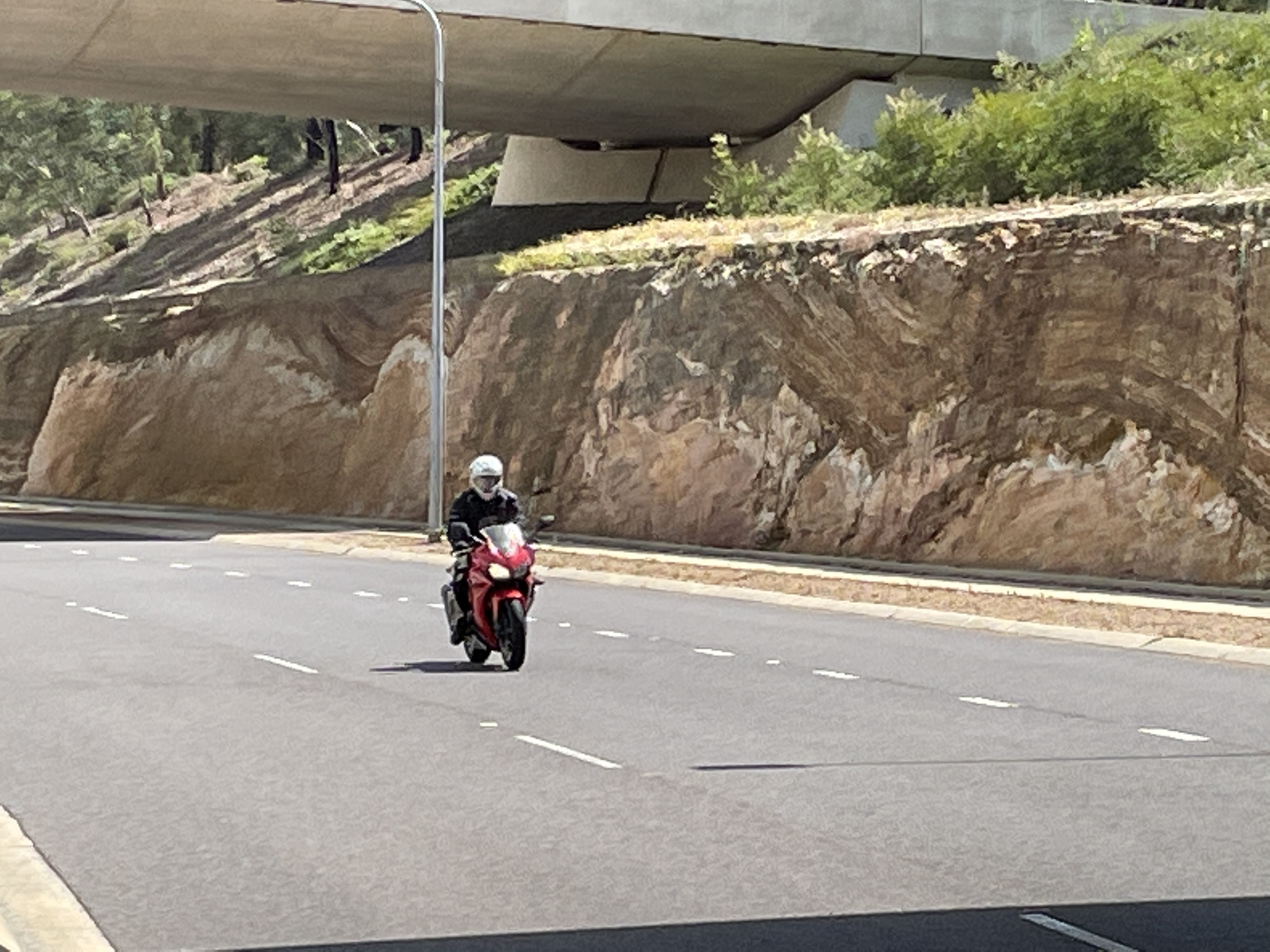 Fig. 3
The failed seaward margin (in the distance) of the sand body can be seen at the left margin of the photo. We have seen that the sediment layers are nearly horizontal there. That isn’t the case on the landward side of the feature, where we see draped intercalated silt/mud dipping at 30 degrees. I don’t want to say too much yet because I’ll address this in the next section, but we need to remember that the landward side of the sand body would have been shielded from wave action; thus, the sediments would not have been as winnowed or dewatered. When an infrequent storm event occurred, therefore, the effects would have been erratic. That is what we see in Fig. 3.
The only other issue to raise, but only briefly, is the sudden change from uniform silt to mixed sand/silt/mud. This is only conjecture, but I’d be willing to propose that transitions are not easily recognized in the stratigraphic record. I’m going out on a limb…maybe I’ll wait.
I should spend a few words on the mixed silt and mud layers, which are obviously important. This area (god only knows how many millennia later) became a tidal flat, as indicated by the mixed sand and mud above the silts we’ve been discussing (Fig. 4).
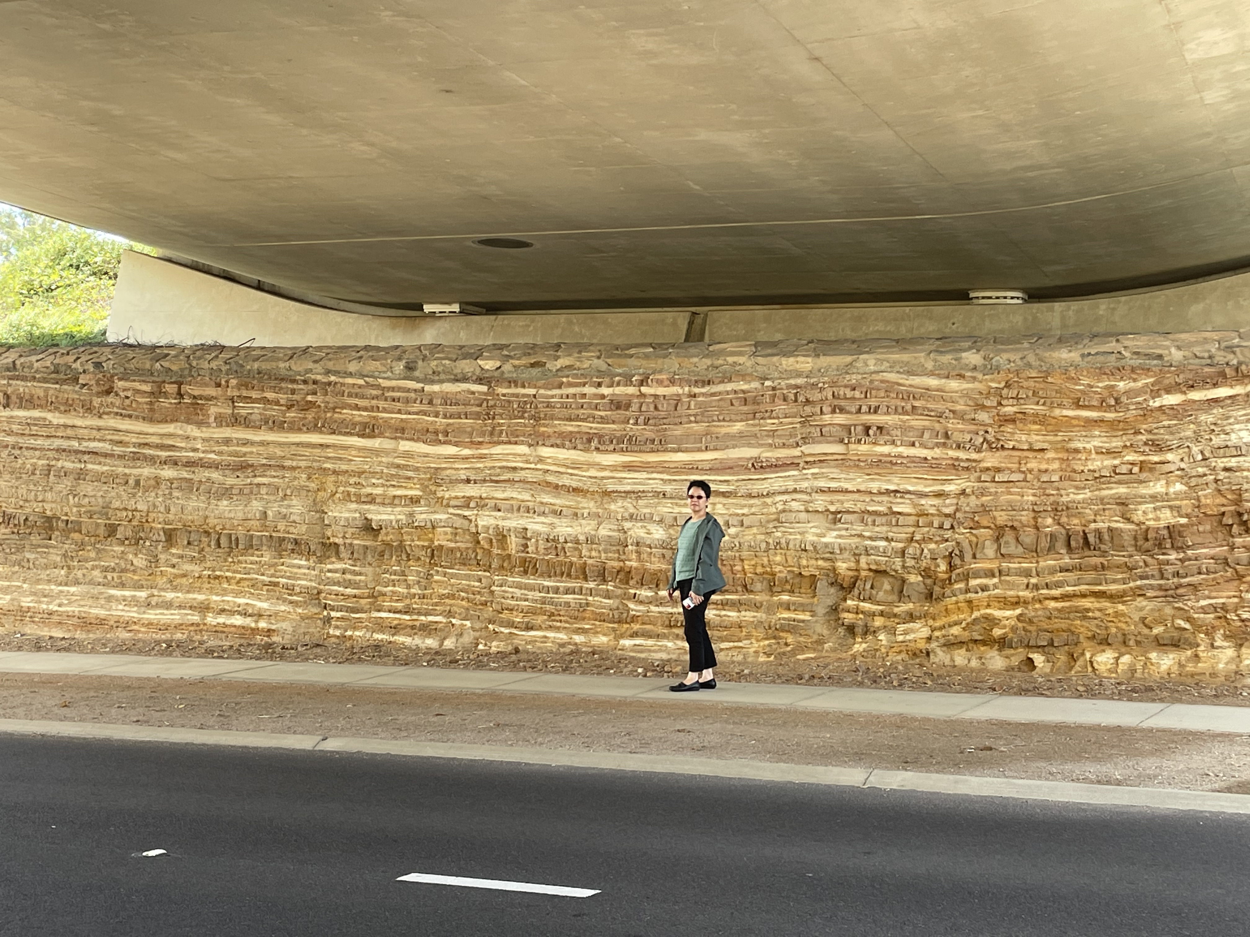 Fig. 4
The depositional environment here in central Canberra didn’t change in a heartbeat. Figure 4 is about 10 feet in height. This looks like a pretty stable environment, from the rhythmic layering of clay and sand/silty sediment. How stable was it?
Figure 4 reveals a stable depositional environment that created at least 3.3 m (I’m using SI for convenience) of sand and mud. Using a conservative depositional rate (for a tectonically active region) of 3 mm/year, we can look at the sediment in Fig. 4 from a temporal perspective: Yoko is standing in front of about 1000 years of sediment. My jaw drops just like yours (should). I had expected it to be at least a million years; there is a caveat, however. Tectonic processes have to make accommodation space (as it’s called in sedimentology) for all that sediment. We can skip to the chase and say that in the Canberra basin, the accommodation space was available because tectonic plate movements (vertical as well as horizontal) made it happen.
Syndepositional Deformation
Anyone who has ever walked along the seashore understands syndepositional deformation. How in the world were the footprints of dinosaurs, birds, even people, preserved in ancient sediments? To be clear, very few events are preserved. When I go to the beach and stand there, letting the waves dig a hole around my feet, my pleasant experience will not be shared with future generations. Very little is preserved in the constantly moving surface world, kept in flux by wind and water. I can’t answer my own question (it’s rhetorical), but here are a couple of examples that might make sense.
I used this picture (Fig. 5) to suggest that mud is stronger than sand and would form boudins but, to be honest I don’t think I have to prove anything. Just look at the record that was in front of my eyes (Fig. 4).
 Fig. 5
The slip-face and resulting Shear Zone led to failure of the seaward-facing (to the left) sand body, so the newly accumulating (over centuries) mud slipped down the slippery slope, forming boudins (indicated by ellipses with squiggling lines), and then everything stabilized. The reason the boundary between the sandy sediment and the mixed sediment is so distinct is the buffering effect of hydrodynamics.
There’s a saying, “It will all come out in the wash.”
That is what coastal hydrodynamics does. Here’s another example (Fig. 6), this time showing how wet sediments can do things impossible for rocks.
 Fig. 6
Figure 6 is less than 10 inches across. The heavy black line tracks a single layer of sediment folded at a ridiculous angle. The ellipses, sometimes filled with squiggles, are boudin structures. The hand-drawn arrow shows the continuity of the “bedding.”
The basic process revealed in Fig. 6 scales up (Fig. 7).
 Fig. 7
Figure 7 is key to understanding syndepositional deformation. It doesn’t matter what caused the shear zone in the figure. The orange lines show layers of sediment remaining coherent while sliding downhill, until the rate of shear/strain was too great, when they became jumbled (scribbly orange lines at bottom-left of Fig. 7). The incompressible sands of the subjacent unit flowed smoothly (black lines), jamming into the shear zone. Some turbulence is indicated at the top of the transition after the slump, but then sedimentation continues, only now dominated by mixed sand and mud (see Fig. 5 above).
Postdepositional Deformation
I haven’t covered a fraction of what this site offers. I am overwhelmed. Serious research studies, integrating this exposure into the other stratigraphic and sedimentological data from the area, are probably underway. I’m going to limit my analysis to what I’ve seen with my own eyes. My interpretation is probably incorrect, but it isn’t because of negligence.
Recalling that these sediments were deposited between 443 and 427 Ma, it is surprising that they are not in worse condition than they are. For example, compare Fig. 3 to photos of the Canberra Formation and the Black Mountain Sandstone from my post on Siliciclastic Sedimentation. All of these rocks are about the same age and were deposited within a few miles of each other.
The rocks comprising the Black Mountain Sandstone are fractured, show signs of extensive cementation, and are tilted in different directions because of faulting. The Canberra Formation rocks are faulted and folded to the point of being overturned. It’s true that the time interval for deposition at these three locations was large (16 million years), which is a very long time. However, we know that regional deformation hadn’t ended because of folding of the younger (424 Ma) rocks at Deakin Anticline.
I would have thought these were Tertiary sediments if I hadn’t looked at a geological map (actually, I used the ROCKD app on my phone). This is an anomalous site.
Nevertheless, these rocks have been deformed. There are high-angle normal faults in this sediment with no evidence of brittle fracture (Fig. 8), i.e., no crushed zones (breccia) or re-cementation (unique minerals and micro veins).
 Fig. 8
Examining Fig. 3 above, we see that the outcrop reveals a very low-angle anticline, which implies that these rocks were compressed (folded) and later went through an extensional stress regime, as clearly indicated by normal faults in Fig. 8. The thin, upper beds have been folded, however, and the faults also show some curvature.
The next example could be discussed as either syndepositional or post-depositional deformation (Fig. 9). It has some elements of both, but mostly I think this feature was created during shallow burial, no longer at the surface and thus post-depositional.
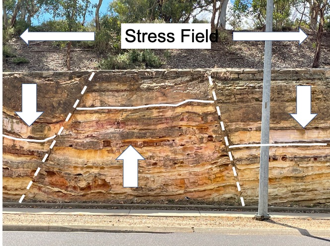 Fig. 9
The white, horizontal line indicates what I think was originally a continuous sediment layer, so there’s about 3 feet of displacement along the normal faults indicated by dashed lines. The block arrows show relative direction of movement of the three blocks seen in the photo. The stress field is tensional, i.e., the sediments/rocks were being pulled from both ends, somewhere other than this outcrop. Note the upward curvature of the sub-horizontal line on the left side of the image. This sediment was not cemented when faulting occurred.
I admit this is pure conjecture but, the narrowness of the Horst (upward moving block) suggests that the two normal faults either converged less than 20 feet up the section, or these sediments were very close to the seafloor when this brittle deformation occurred. It isn’t too difficult to imagine faults splitting and joining because rocks are heterogeneous when buried and somewhat ductile, so maybe…
Spatial and Temporal Variability
I was unwilling to say too much earlier, but now is the time to speak openly. The sudden change from relatively pure very-fine sand and silt to intercalated silt/mud that is so obvious in this outcrop didn’t happen. The river and ocean system didn’t switch one day, and stop delivering/depositing massive volumes of silt. Mud didn’t occur magically as if a dump truck (of immense size) had unloaded into whatever primordial river ran through this area ~430 million years ago.
This is an example of how subtle changes in a complex system like the earth’s surface aren’t evident immediately. A system as complex as the lithosphere-atmosphere-hydrosphere adjusts to slight changes, until it doesn’t. Then — Voila — a suddenly very different situation. The childish interpretation, that the world is a very simple place and abrupt changes in the geological record, as we’ve shown in this post, are the result of intelligent-design — Gaia, God, a horned toad with superpowers, Aliens…whatever — fails to account for our nascent understanding of nonlinear systems.
I have a simpler explanation: Stratigraphy doesn’t immediately record transitions in the geological environment because fluid-dynamic-driven, processes like sedimentation, act as a buffer that smears transitions out, over thousands of years. The earth’s surface is three dimensional. The stratigraphic sections we’ve been examining make that obvious. Time is another element; but it isn’t directly correlated to the vertical dimension in stratigraphic sections of sedimentary and volcanic rocks (both deposited horizontally).
I will address the disparity in deformation in the last post of this series.
Australian Capital Territory: Siliciclastic Sedimentary Rocks
This is the third post from the ACT. For an overview take a look at the first post.
This time I’m going to visit several locations from the Canberra area that show the variability of sediments during the orogeny. Figure 1 gives some idea of the complex history sand and mud particles have after being deposited in the ocean. We’ll talk more about that in the next post, but for now we’ll compare the sediments.
 Fig. 1
The rocks in Fig. 1 are estimated to have been deposited between 443 and 427 million years ago (Ma). The white rock has a lot of features that we’ll look into next time. For now, notice that the overlying thin bedded light-and-dark layers appear to be in continuous contact with the lighter rock. Ignore the displacement along faults.
This sediment consists of uniformly fine-sand-to-silt particles. The steep cross-bedding (Fig. 2) suggests this was a nearshore marine environment with strong wave action, producing submarine bars and probably a steep delta-front winnowed by wave turbulence.
Fig. 2
The cross-bedding suggests transport from the right side of the photo, so fine sand was coming from an easterly source (e.g., NE to SE), probably near a river mouth. Imagine the mouth of the Columbia River, draining the Cascade Mountains. A lot of sand is deposited in giant spits and sand bars. The cross-bed sets (Fig. 2) are ~3-4 feet thick and dipping seaward (to the left). Note the near-horizontal orientation of the conformable sediments overlaying this unit. This is very close to the deposition angle.
What about the overall shape of the sand body? At this outcrop, we are able to see what appears to be a cross-section of this submarine feature (Fig. 3).
Fig. 3
The photo is taken looking offshore along the paleo-shoreline, so the contact between the sand body and the overlaying sand/mud sequence dips landward and shows some irregularities (note the tongue protruding upwards to the right of the motorcycle). It reaches its maximum thickness in Figs 1 and 2 (left of the biker in Fig. 3) and is truncated by a fault. It looks like a fairly large submarine bar , maybe 200 yards across. Could have even been a barrier island or shoal that was buried by mud.
There is one last feature to mention in passing about this outcrop. The contact between the fine sand body and the overlaying mixed sediment indicates deformation of the sediments when they were still sediments, i.e., before burial (Fig. 4).
Fig. 4
 A
A  B
B
Figure 4A shows a pinching to the right of Yoko, forming narrow necks separated by lozenge shaped dark sediment. This structure is called “boudin” because it looks like a sausage. In sediments, it occurs when mud is stretched overlaying sandy sediments, which are very weak in extension. This conjecture is consistent with extension indicated by normal faults seen throughout the exposure. Figure 4B shows filling of channels by the underlying coarse sediment, analogous to a river flood channel being filled in. Note that the sediments are dipping ~10 degrees to the right in panel B and take that into account.
A closeup view of Fig. 2 reveals extensive dragging of sediment layers along both sides of the faulted contact between the two units. This cannot happen with deeply buried and partially cemented rocks.
The exposure we’ve been discussing is located near Site 22 in Fig. 5. The next stop takes us to Black Mountain, Site 4 in Fig. 5, where we’ll examine some turbidites deposited during the same broad interval (443-427 Ma).
Fig. 5
The Black Mountain Sandstone is called a flysch, part of a sequence grading from deep water turbidity current sediments to shallow water shale and sandstone. We aren’t going to be able to determine that much detail from our field work. The beds vary from nearly horizontal (Fig. 6) to dipping at more than 30 degrees (Fig. 7).
Fig. 6
 A
A  B
B
Figures 6A and B were taken at a single exposure along a road cut. The thin sand layer (white in both panels) is continuous between them. This layer is less than 1 foot thick. A massive sand layer is separated from it by layer of mud.
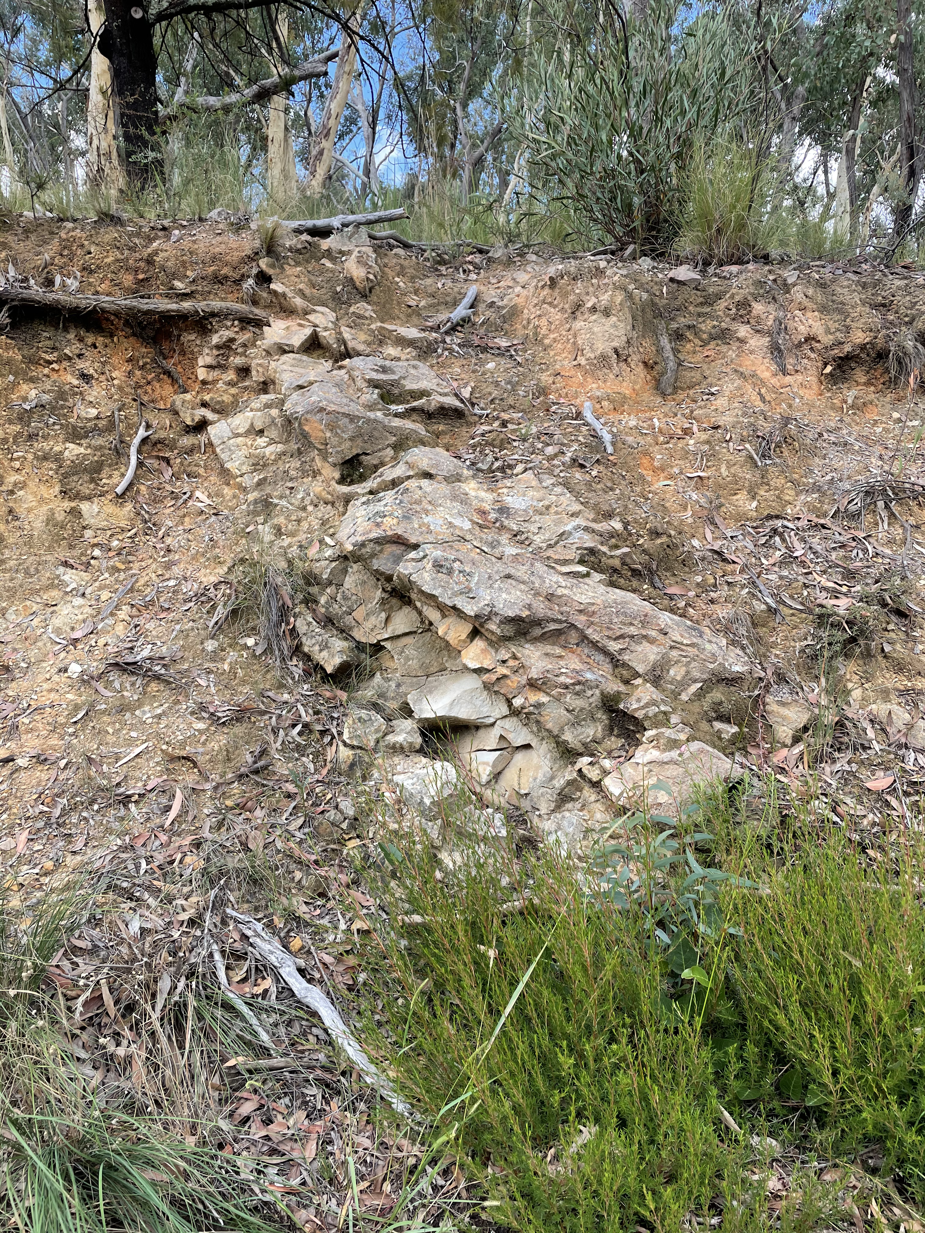 Fig. 7
Figure 7 is how the rocks typically appeared. They are jointed and brittle and it is difficult to discern any sedimentary structures in them (Fig. 8).
Fig. 8
 A
A  B
B
A close-up examination of Fig. 8A suggests that there are some larger particles present, but I wouldn’t bet on it. Discerning fine sediment structures in fine-sand turbidites requires breaking a lot of hand samples off from the exposure, and I don’t do that. I have to live with what’s visible at the outcrop. There is a hint of slight cross-bedding, dipping to the left in the lower-right corner of panel A. Figure 8B gives the impression of layering that dips to the left as well (these samples were in place but the photos are not oriented). There is also evidence of angular fragments consistent with a turbidity current, which transports larger grains as bed load in a predominantly fine matrix.
We had the opportunity to take a few photos of a spectacular road cut of the Canberra formation (also 443-427 Ma) located on the eastern edge of Fig. 5. This formation consists of finer clastic sediments and some volcaniclastics. We couldn’t stop for a close examination because of heavy weekend traffic and no place to pullover, so we drove slowly where there was a passing lane and took a lot of photos. Figure 9 is representative of what we saw (after the fact).
Fig. 9
 A
A  B
B
These were two identifiable (to me) folds with thrust faults. The area labeled “Fault Zone” had no recognizable bedding and tended to be fragmented. Other photos revealed vertical to overturned beds or breccia zones with no discernible structure.
The final example of siliciclastic sediments from this orogeny is from Site 10 (Fig. 5), a fine-grained, volcaniclastic sandstone deposited around 424 Ma.
Fig. 10
 A
A  B
B
 C
C 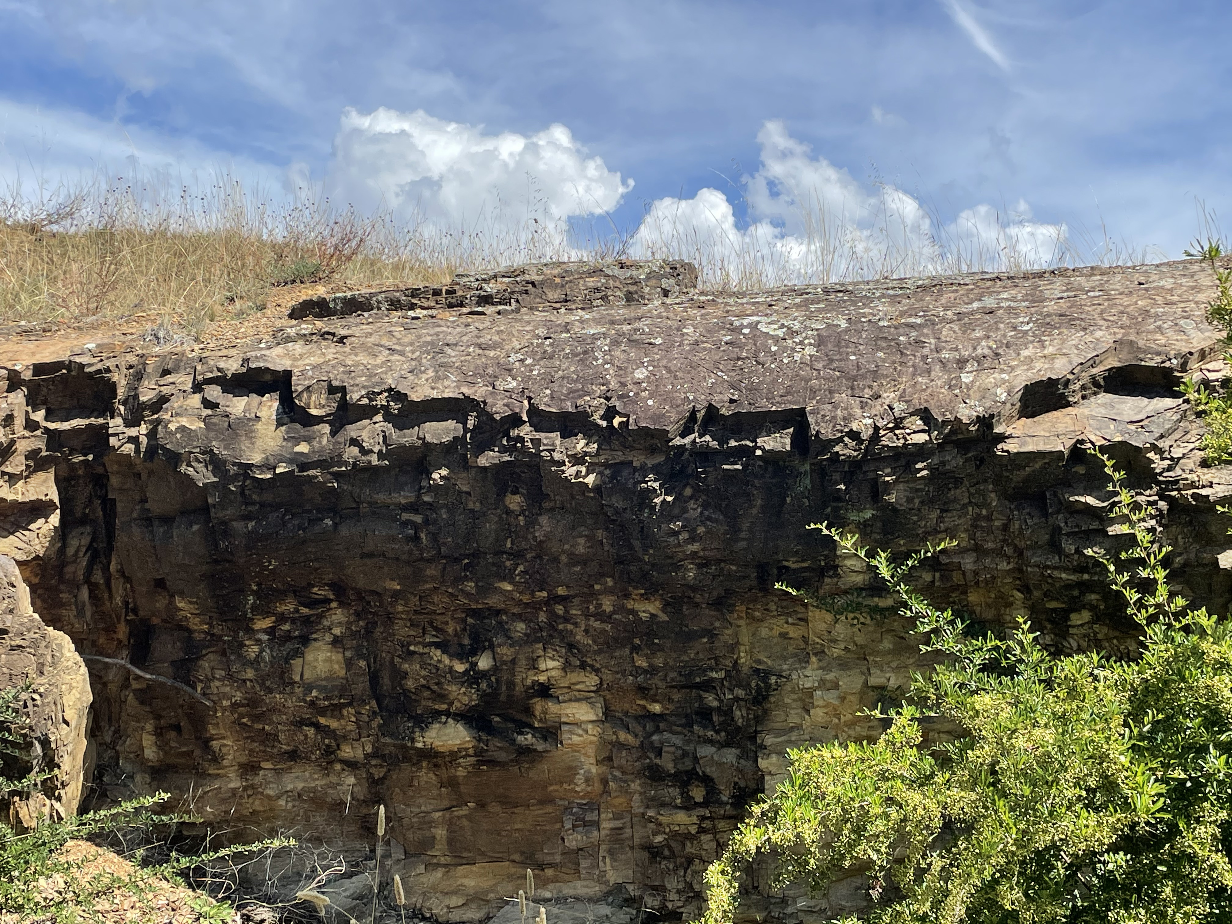 D
D
Figure 10A gives more technical details than I can give, and it is a good example of how seriously Australian’s take geology. Anything accessible has a sign explaining its geological history. Panel B shows the anticline hinge that made the site famous. Figure 10C shows the fine lamination expected in a fine-sandstone, with indications of soft-sediment deformation as well (near the key fob). Panel D shows what’s left of the hinge point. Looking back at Fig. 10B, the hinge (greatest curvature) is to the left of Yoko. That’s what is shown in panel D. In other words, this anticline was folding over like so many others (e.g., Fig 9) when the rocks were deeply buried and being compressed. I walked all around the site but found no glaring evidence of the fault referred to in Fig. 10A.
That does it for this post. We’ve looked at sediments deposited over a 60 million-year interval during an orogeny, and how they’ve been deformed since. We’ll get back to that in a later post, when we put this road trip into the bigger picture.
Australian Capital Territory: Lake George
For details about the big picture, take a look at the first post in this series.
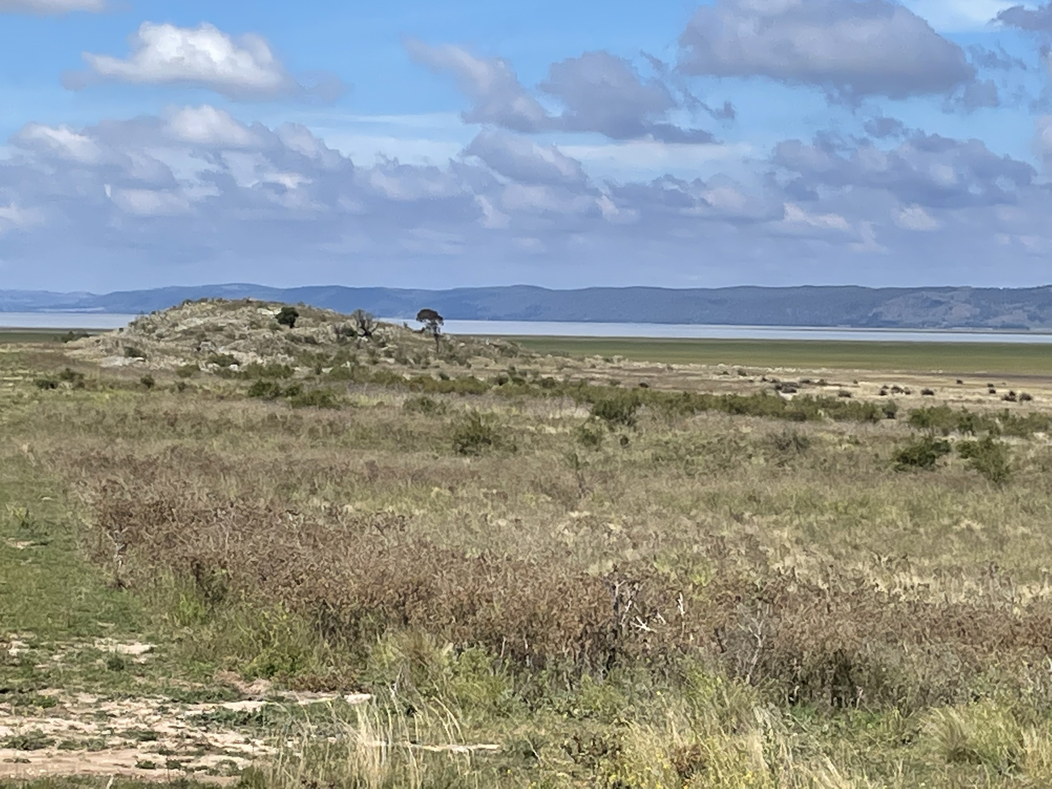
This post goes back to the beginning of the mountain building event, about 485 Ma in the past. We took a drive to Lake George, about 40 km NE of Canberra, just over the border in the state of New South Wales. Lake George is a shallow depression with no outlets and very little inflow. Thus, it is often dry and water depths are on-average about 1 m (Fig. 1).
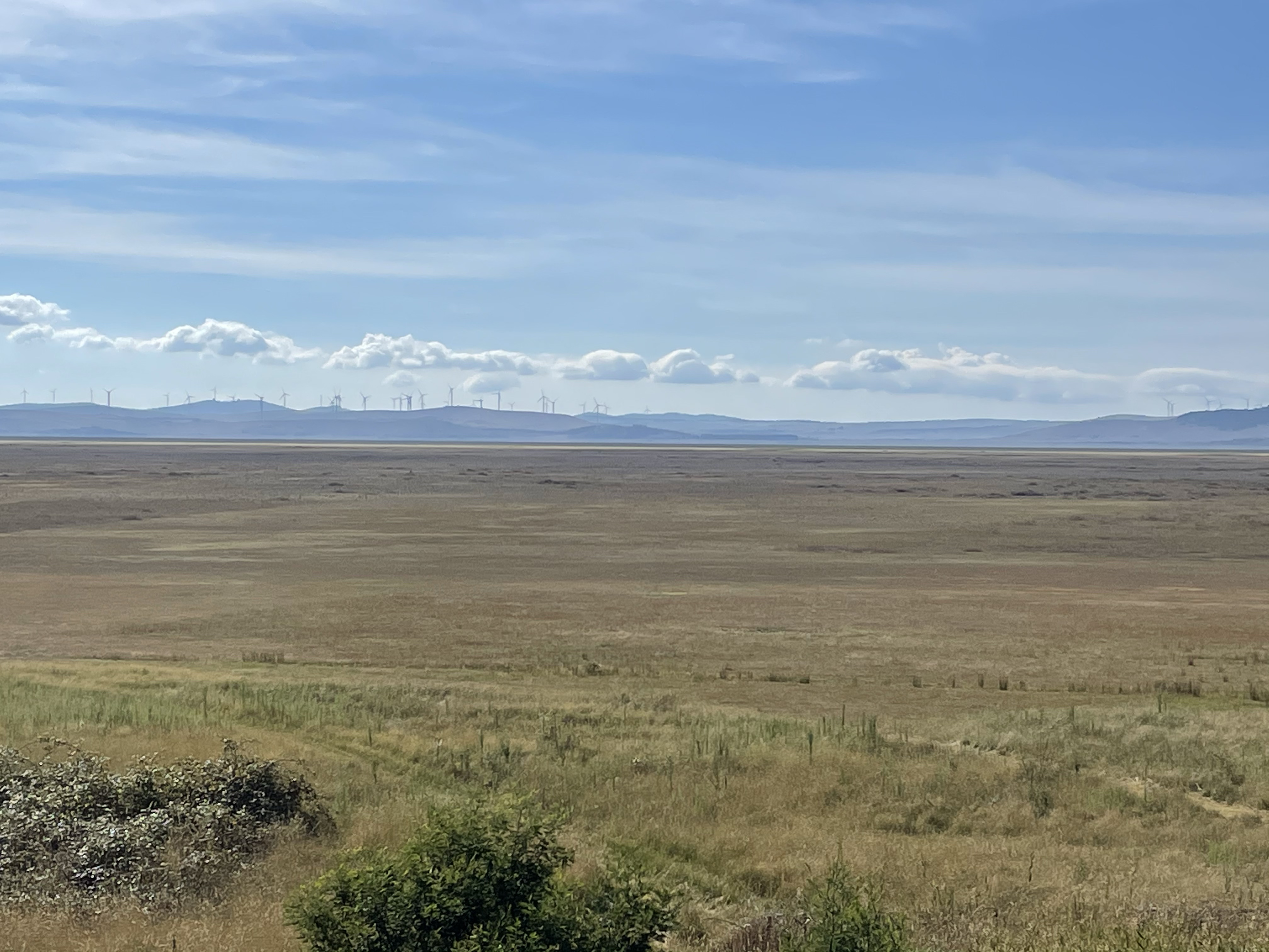 Fig. 1
It was mostly dry when we visited. Figure 1 looks across the lake to the east from the west side (location shown by red circle in Fig.2). We’ll be circumnavigating the basin in this post.
 Fig. 2
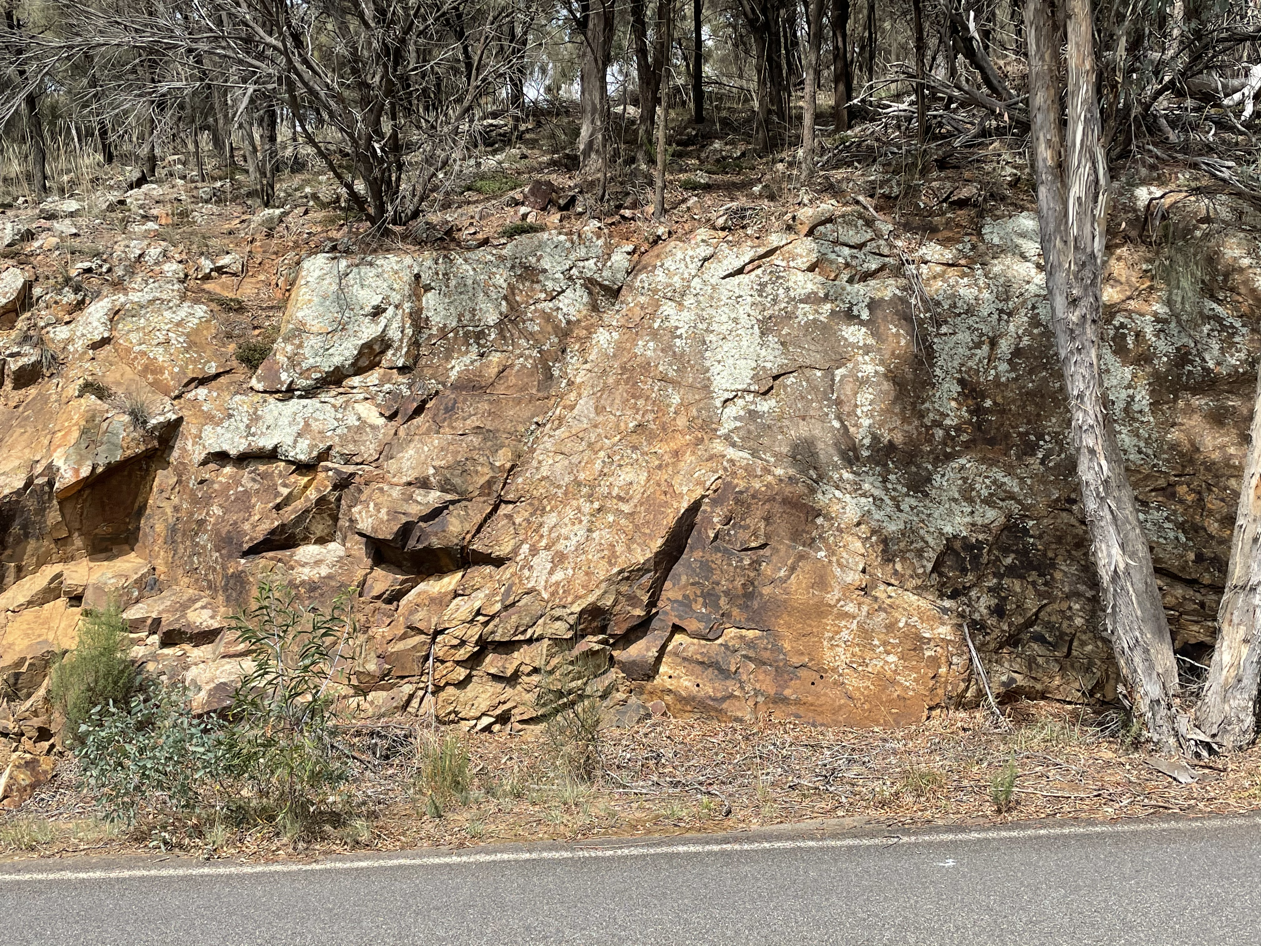
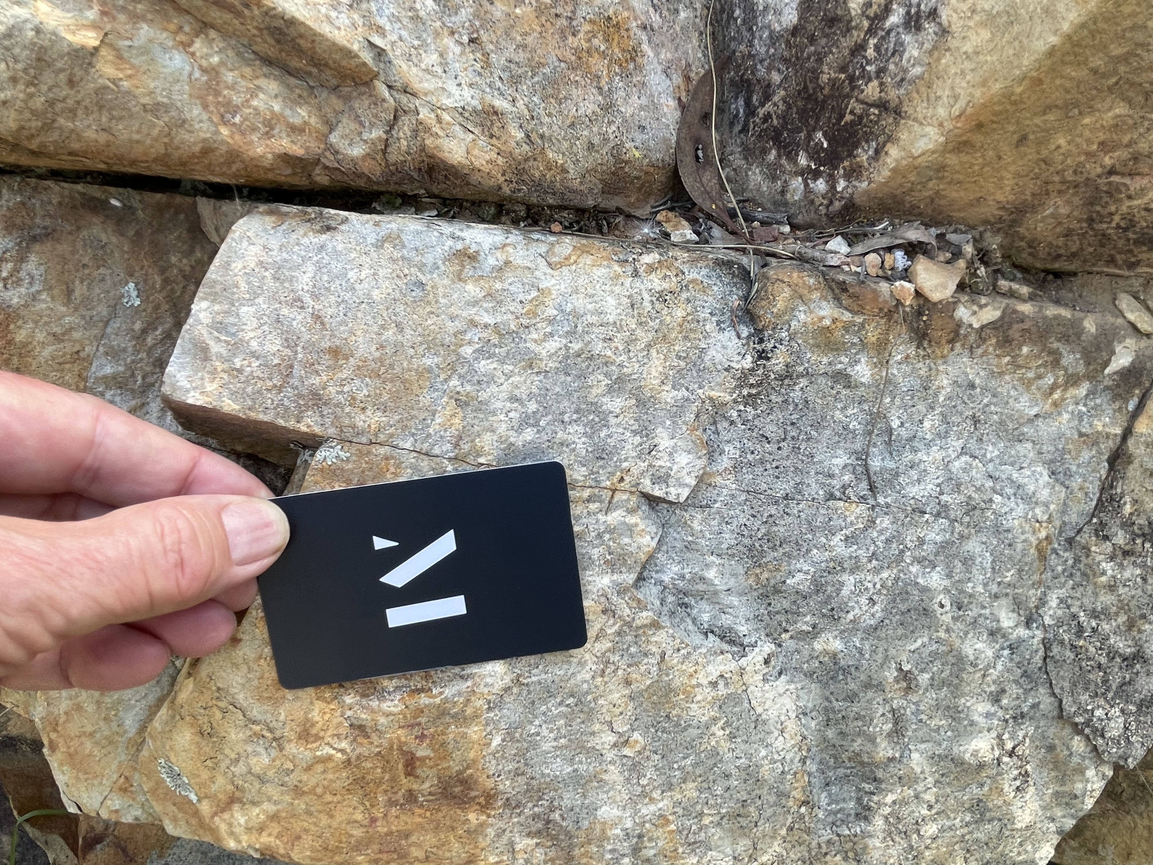
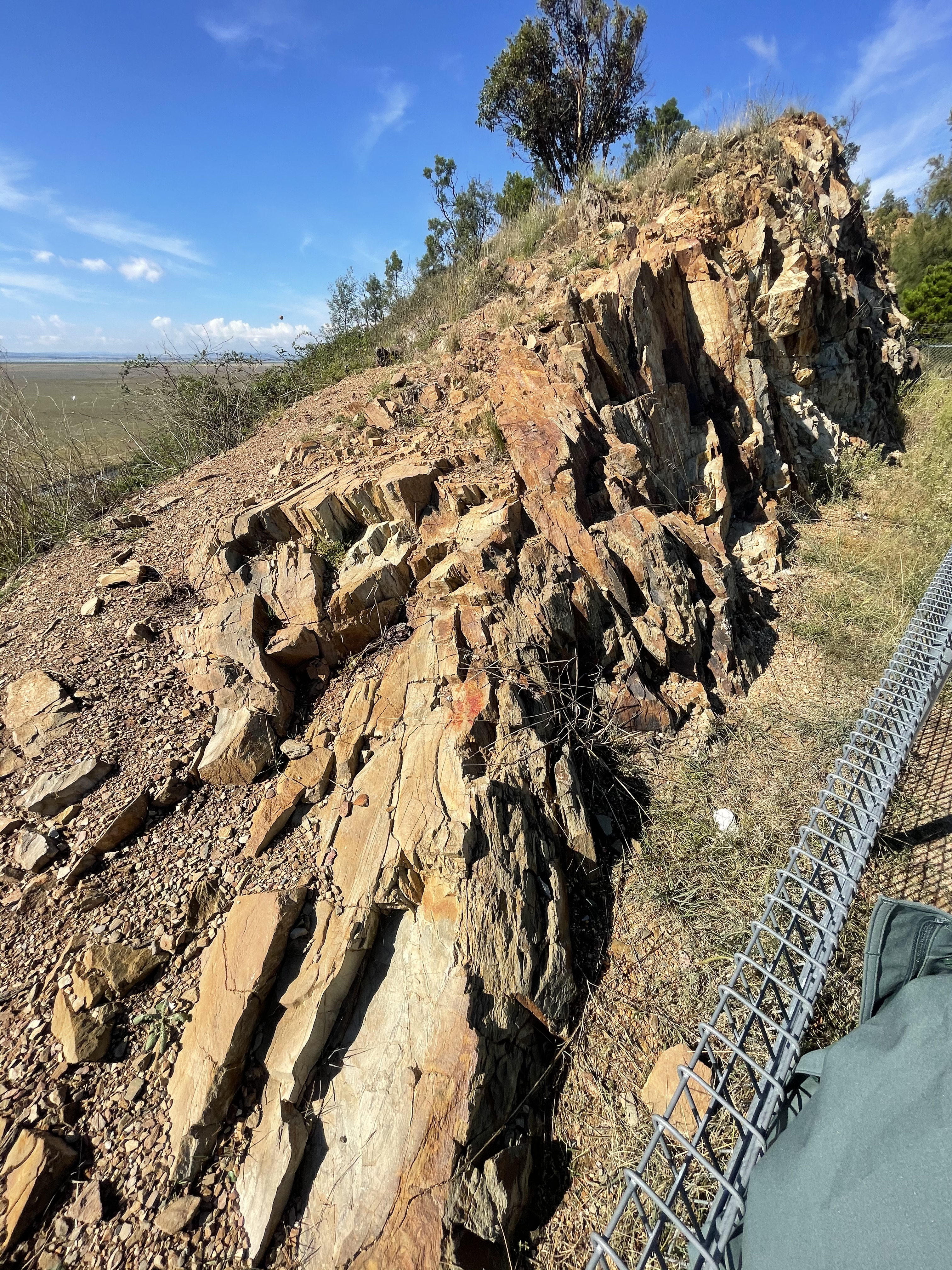
Lake George has a long geological history, including uplift of the west side of the basin within the last tens of millions of years. This faulting has brought Adaminaby Group (485-443 Ma) sedimentary rocks to the surface after more than 300 feet of uplift. This is a turbidite sequence of sandstone, mudstone, shale, greywacke, chert; quartzite, phyllite, slate (Fig. 3).
Fig. 3
 A
A  B
B
These beds consist of alternating fine grained sandstone and siltstone, with shales containing sand lenses. They are dipping steeply to the NE, but this faulting is not associate with the Paleozoic orogeny discussed in these posts.
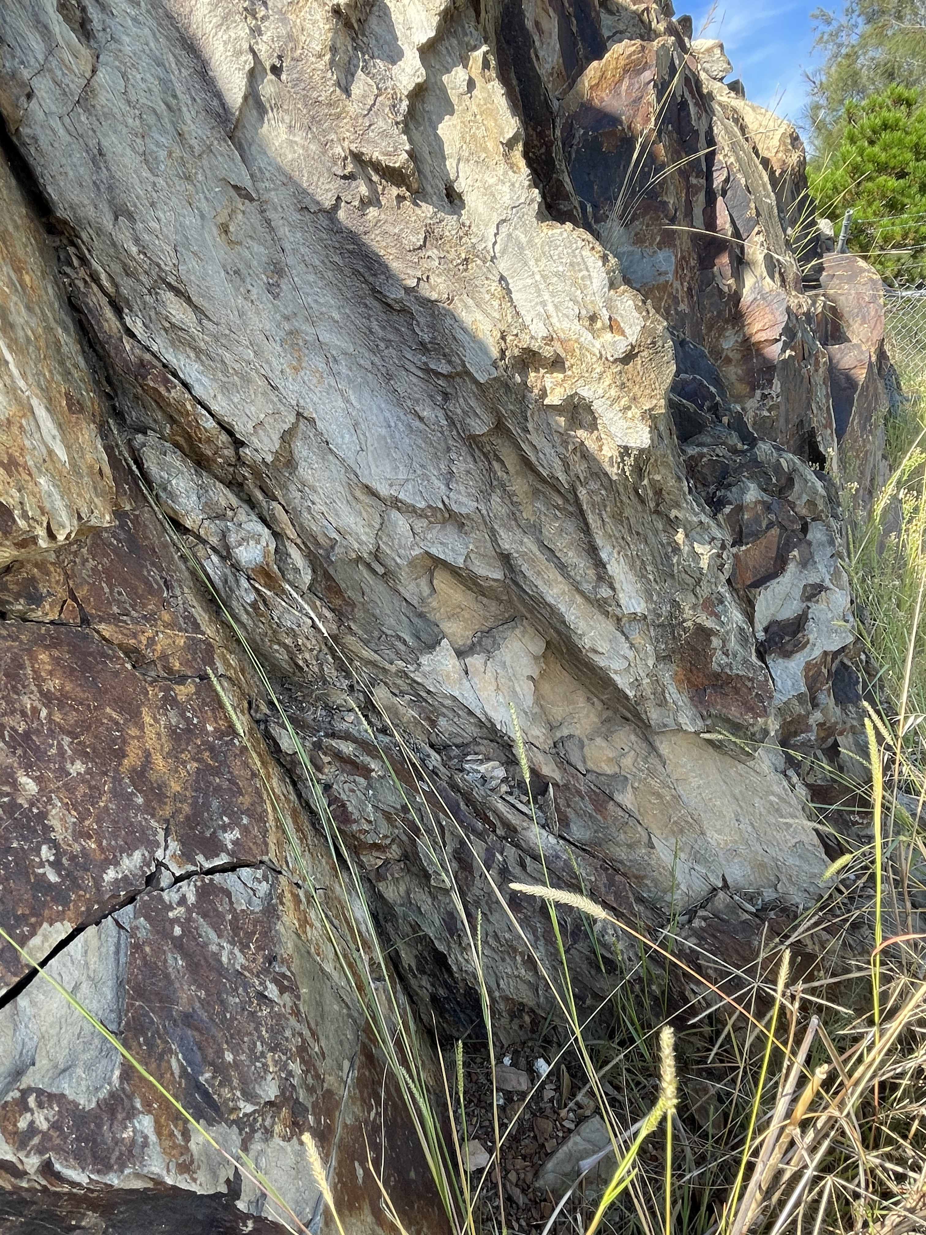
Examining the rocks up closer (Fig. 4) reveals fine textures supporting the proposed turbidite depositional environment.
Fig. 4
 A
A 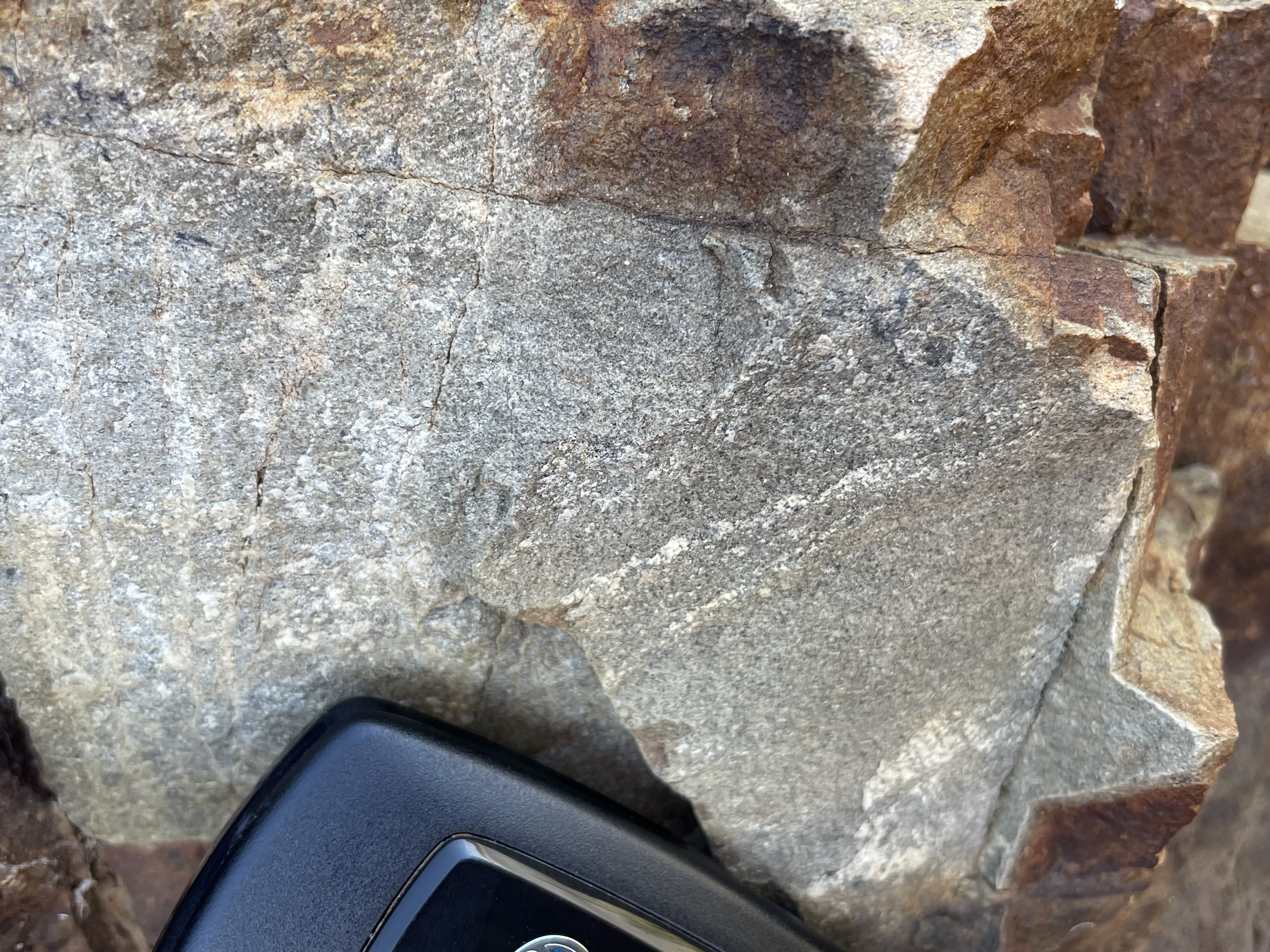 B
B
 C
C
Figure 4A shows a bed ~6 inches thick, tilted 60 degrees to the right. Zooming in on it reveals thin cross-bedding intersecting joints. Figure 4B shows graded bedding, with slightly larger grains revealed in the white layers against the grey background of smaller grains to the right of the sample. Panel C reveals sets of laminae at low angles, intersected by joints filled with cement.
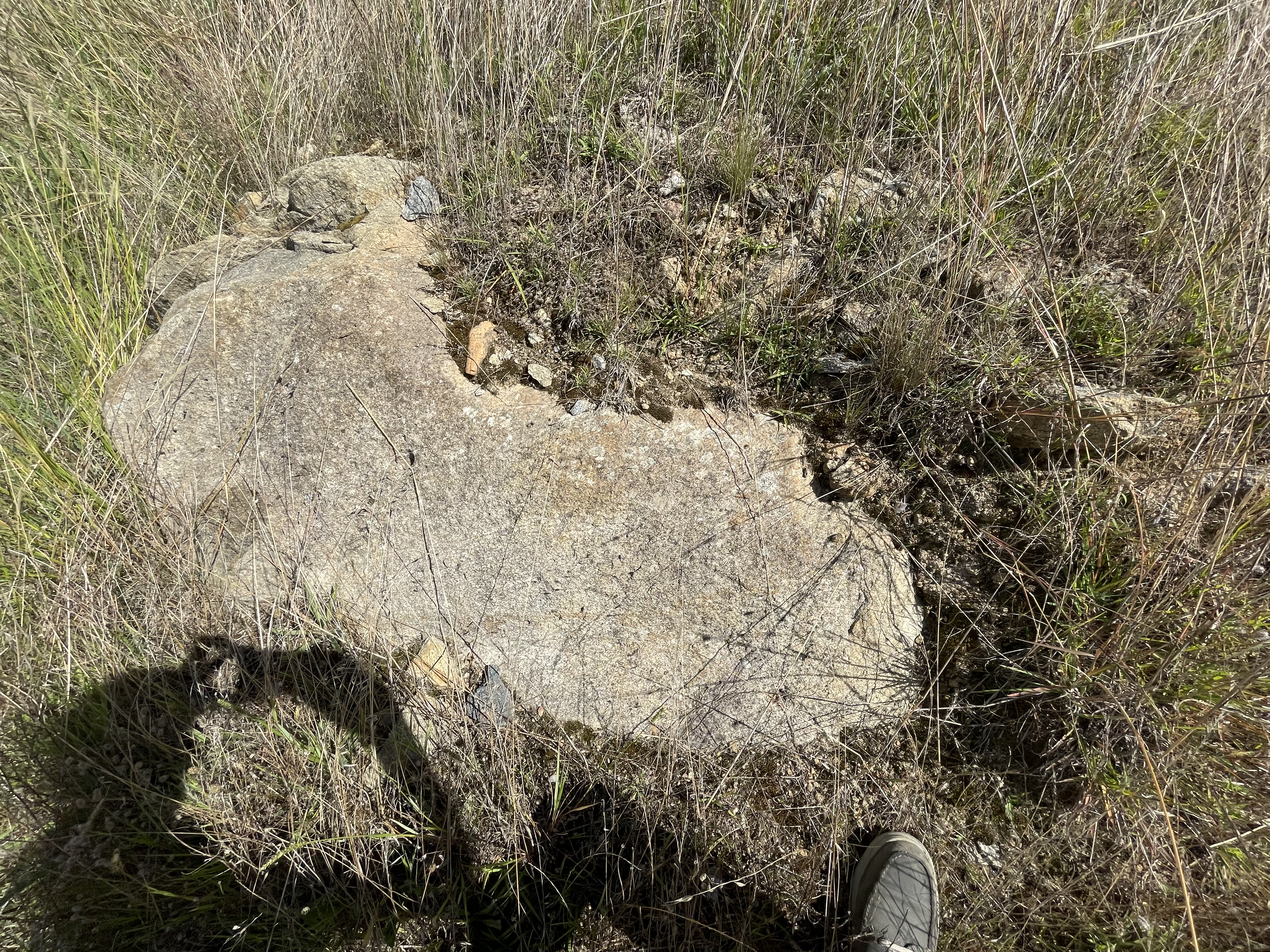
We followed a narrow asphalt road, which became gravel, to the NE side of Lake George (see Fig. 2), crossing through volcaniclastic and siliciclastic rocks deposited towards the end of the orogeny (433-410 Ma). There were no outcrops of these sedimentary rocks, however, and only a few sandstone beds were visible in ditches. The dominant exposed rocks were outcrops of small boulders of a gray, fine-grained igneous rocks on low hills (Fig. 5).
Fig. 5
 A
A  B
B
 C
C
Figure 5 shows small outcrops (< 2 feet in length) of in-place fine-grained rock with large quartz crystals along joint surfaces (Fig. 5A) and as veins within joints (Fig. 5B and C). This fine-grained rock is part of a granitic pluton about 420 Ma in age, towards the end of the orogeny. The fine-grained rock may be overlaying volcanics into which the granitic rock was intruded at this location, although no intrusive rock was visible.
We followed a track to get as close to Lake George as possible (Fig. 6), where a small hill could be seen in the distance with outcrops visible. Most of the larger hills were covered with soil. This is a heavily eroded granitic pluton.
Fig. 6
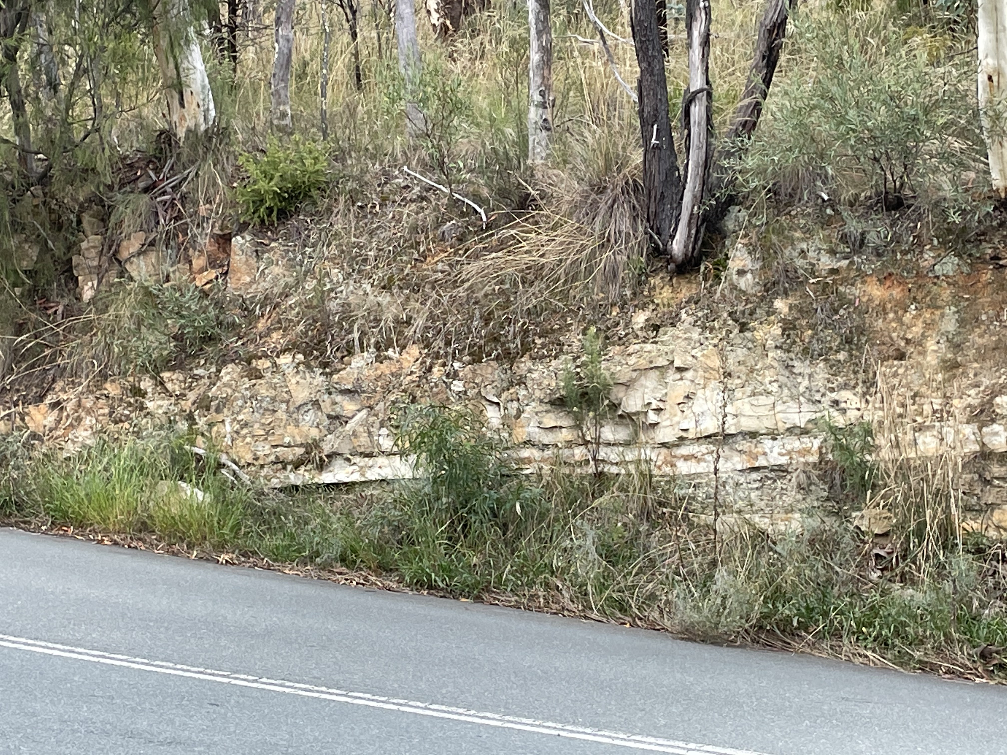
A few miles further east took us back into the oldest rocks again (~485 Ma), to the east of Lake George (Fig. 7A), where we found thin bedded siltstone and shale (Fig. 7B).
Fig. 7
 A
A 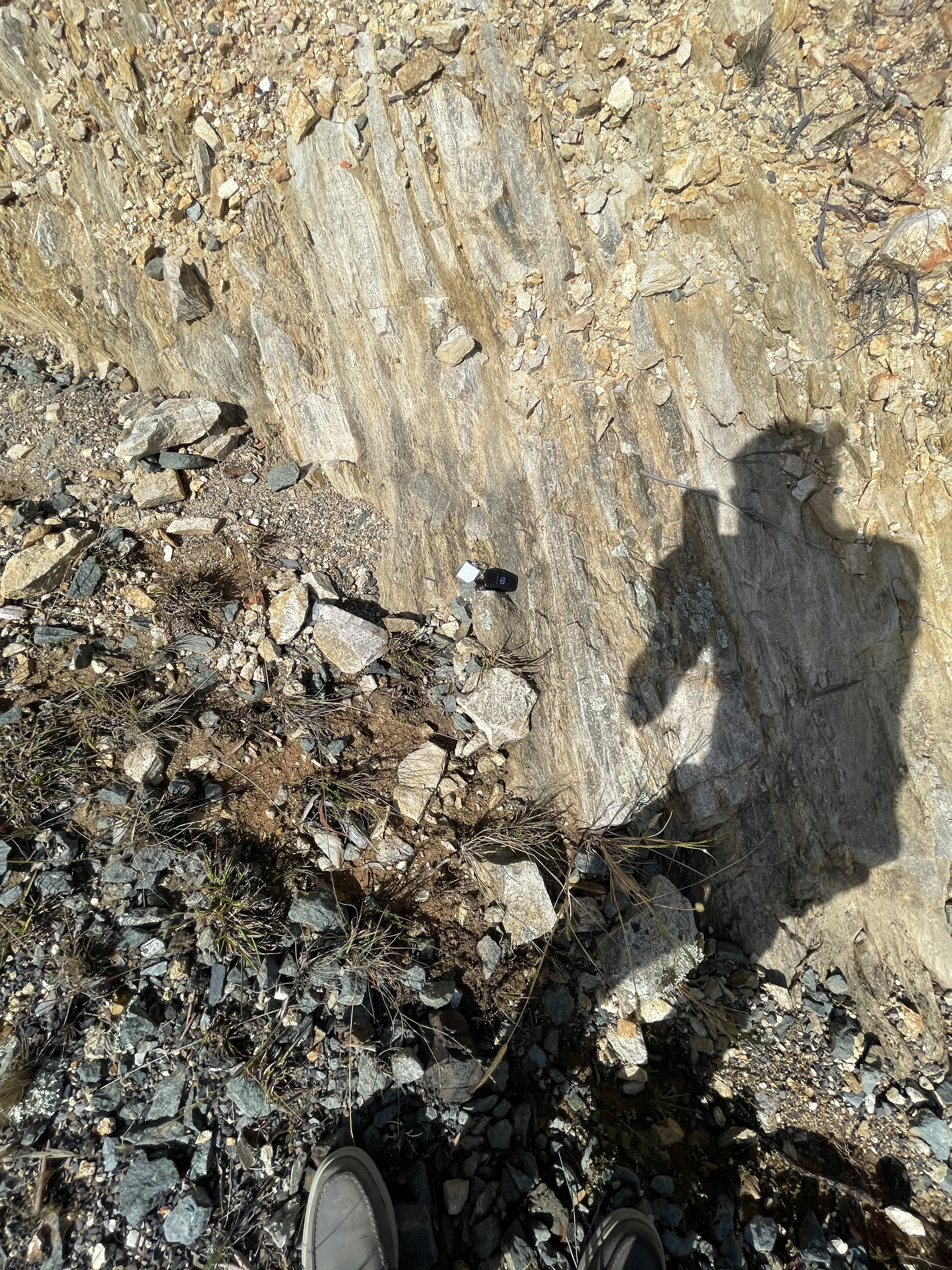 B
B
A short distance further finally revealed the granitic basement (Fig. 8).
Fig. 8
 A
A  B
B
 C
C  D
D
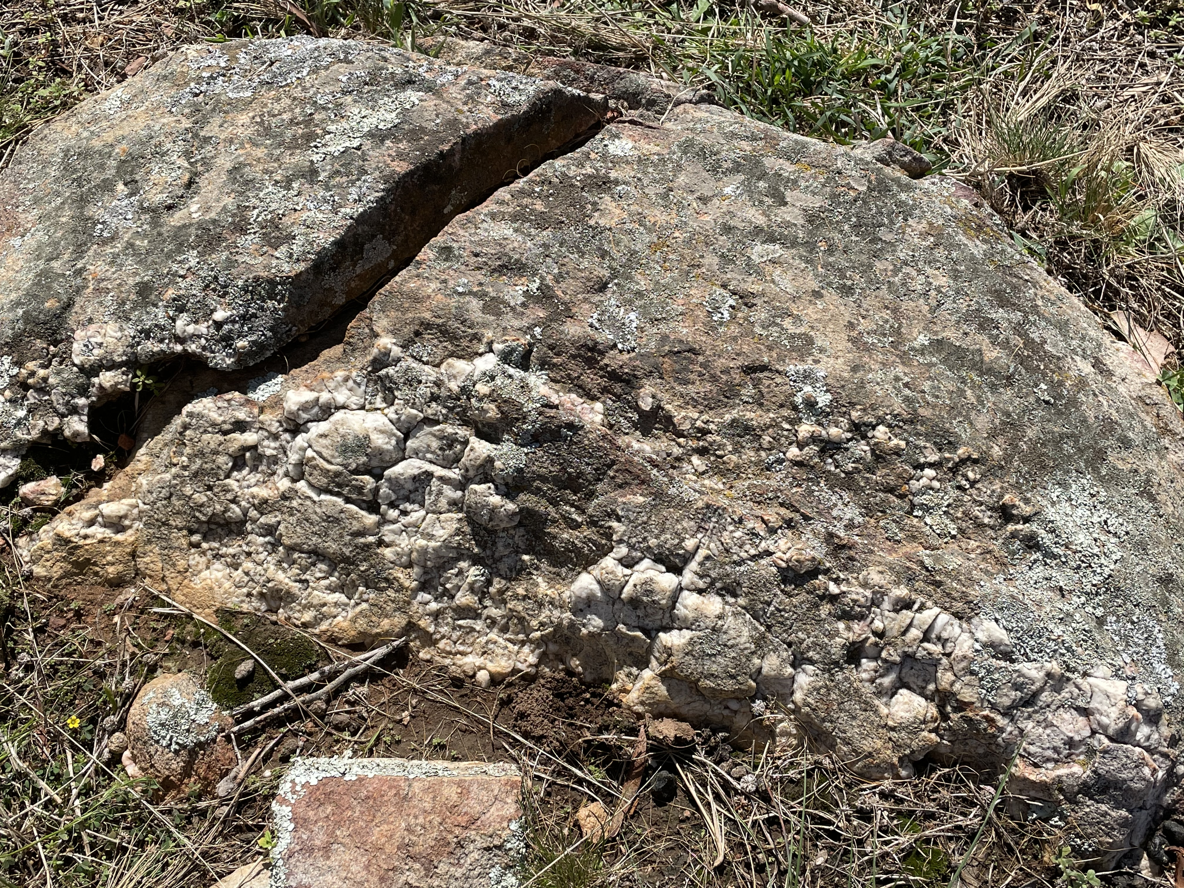
Figure 8A shows the largest outcrop we found. It is about 4 feet across. A closer look reveals a granitic texture, with alkali feldspar and quartz visible as the pink-to-white and gray crystals, respectively (Fig. 8B). An even closer look (Fig. 8C) verifies the overall impression we have from panel B. However, this is not a homogeneous granite as seen in panel D, which shows contamination by lithic fragments (angular grains) and evidence of strain (shear displacement) as the magma was cooling, producing weak lamination within the darker part of Fig. 8D.
This post has circumnavigated a shallow basin surrounded by rocks from representative intervals during the orogeny. The oldest sedimentary rocks (~485 Ma) contain turbidites deposited on steep continental shelves where the land is rising. Deposition of these proximal (deposited near rising land) turbidites and greywackes continued as explosive volcanism began to dominate nearby. The sediments are from the ocean whereas the volcanics (Ignimbrites and tuffs) were deposited on land. This continued until granites were emplaced by about 420 Ma.
Next time, we’ll closer at the sediments deposited during this long interval.
Australian Capital Territory: The Great Dividing Range
We are on a quick trip to Canberra the capital of Australia located in the Australian Capital Territory, which is analogous to Washington DC, but it’s called the ACT for short. It’s about halfway between Melbourne and Sydney, in the state of New South Wales. I’m doing the post a little different this time. This is the first post. I may update it to keep the information all together, or I may make a separate post. I don’t know yet.
We’re going to start in the present. Figure 1 shows what the Paleozoic orogenic belt we will be examining looks like today. The figure was taken from the Telstra Tower, sitting atop Black Mountain on the outskirts of Canberra, looking to the NNE. We’ll be heading that way in our next post.
 Fig. 1
The rocks from this area are dated between 485 and 407 million years ago (Ma). The oldest rocks are greywacke, deposited in the ocean from a rapidly rising landmass (labeled D in Fig. 2A). The youngest are rhyolite tuff and associated volcaniclastic sedimentary rocks (labeled C in Fig. 2A). That’s a long time span, but it gives one an idea of how slow geological processes occur. However, these rocks record an orogeny in its entirety, from the first sediments deposited from rapidly rising and eroding mountains, to the emplacement of plutons and volcanism. Of course, it’s difficult to identify the exact date an orogeny begins or ends; after all, when does an orogenic belt become an eroding mountain range?
A geologic map of the area (Fig. 2) shows the complex geology associated with an orogeny lasting more than 70 million years.
Fig. 2
 A
A
 B
B
Figure 2A covers a larger area and indicates some potential locations to examine as well as several common rock units. Figure 2B is a closeup map of the Canberra area. (Note that rock units do not use the same references in Figs. 2 A and B.)
There are many recognized field sites in the ACT and they are listed with descriptions and access instructions in a publication of the Australian Geological Society.
The numbers on Fig. 3 refer to site numbers, each of which has a separate document.
Fig. 3
A  B
B 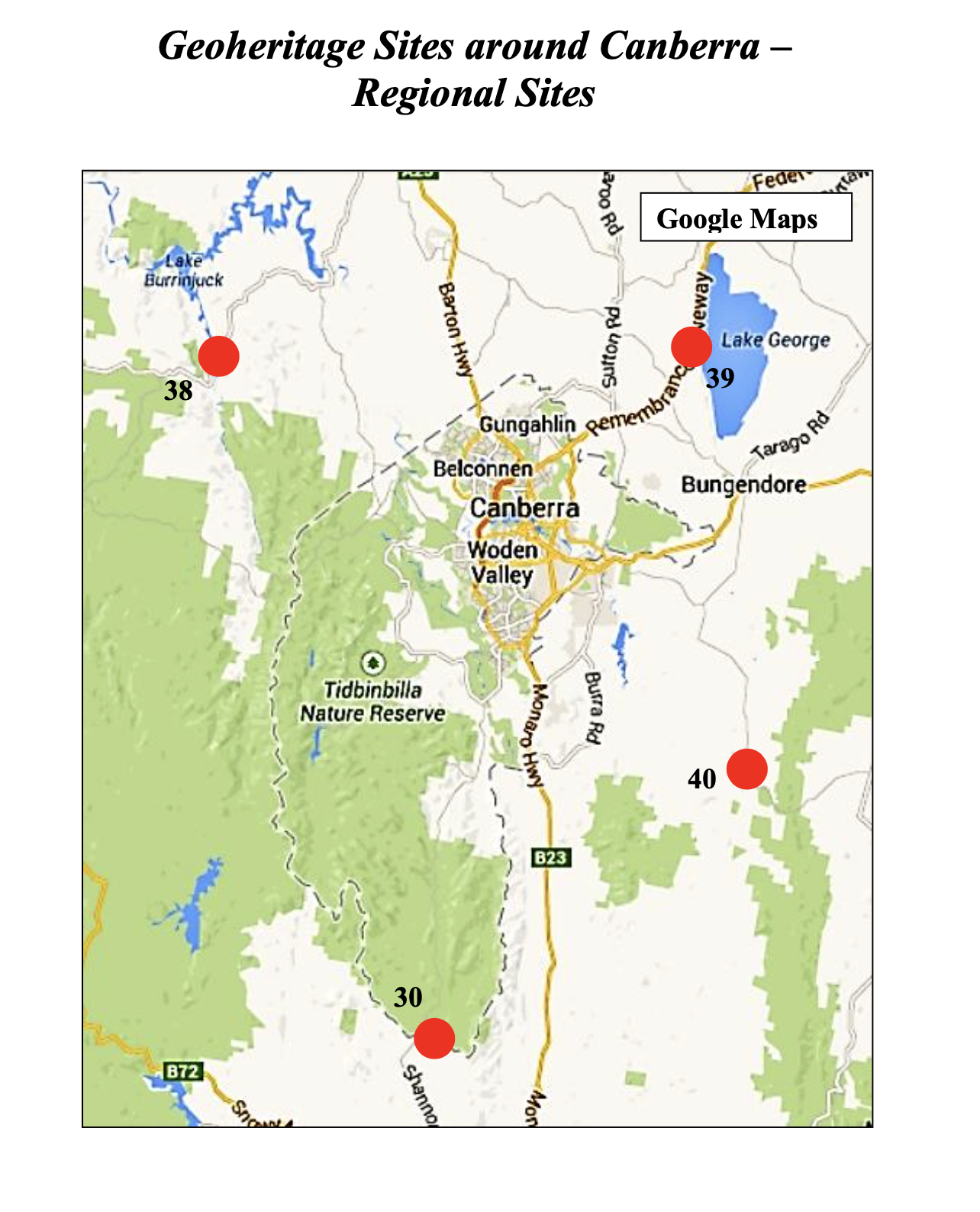 C
C
We’ll be visiting several of these locations on Friday and Saturday.
39 – Lake George: Late Ordovician (485-443 Ma) quartz turbidite and black slate (Adaminaby Group). Silurian (~420 Ma) turbidites, volcanics, and granite.
04 – Black Mountain: Siliciclastic sequence (443-427 Ma); proximal flysch sequence.
00 – Canberra: Canberra Formation (443-427 Ma): Mudstone, siltstone, minor sandstone; dacitic ignimbrite; volcaniclastic sediments, ashstone. State Circle Shale/Black Mountain Sandstone (443-427 Ma). (This is a shared post with 04 but in a different location, which is not in the guide book.)
16 – Mount Ainslie: Mount Ainslie Volcanics within the Hawkins Volcanic Suite; erupted 428-424 Ma.
26 – War Memorial Conglomerate: Dacitic agglomerate within the lower part of the Ainslie Volcanics (428-424 Ma). The agglomerate is composed of angular clasts of greyish dacitic tuff.
10 – Deakin Anticline: A well developed anticline, with a fault between two rock outcrops in volcanoclastic fine sandstone and siltstone of the Yarralumla Formation (424-423 Ma).
31 – Botanical Garden: A conglomerate formed on an alluvial fan, thought to be of Pliocene (2-3 Ma).

Recent Comments