
Shenandoah National Park: Precambrian Volcaniclastic Rocks

Figure 1. View looking west from Dickey Ridge/Hill (See Fig. 2) towards the Shenandoah Valley. This is where the Ridge and Valley province begins, a series of elongate mountains running approximately 30 degrees east of north, the same as the structural trend we’ve seen in previous locations throughout northern Virginia. Dickey Hill has an elevation of 2427 feet, about 1800 feet higher than the valley floor.
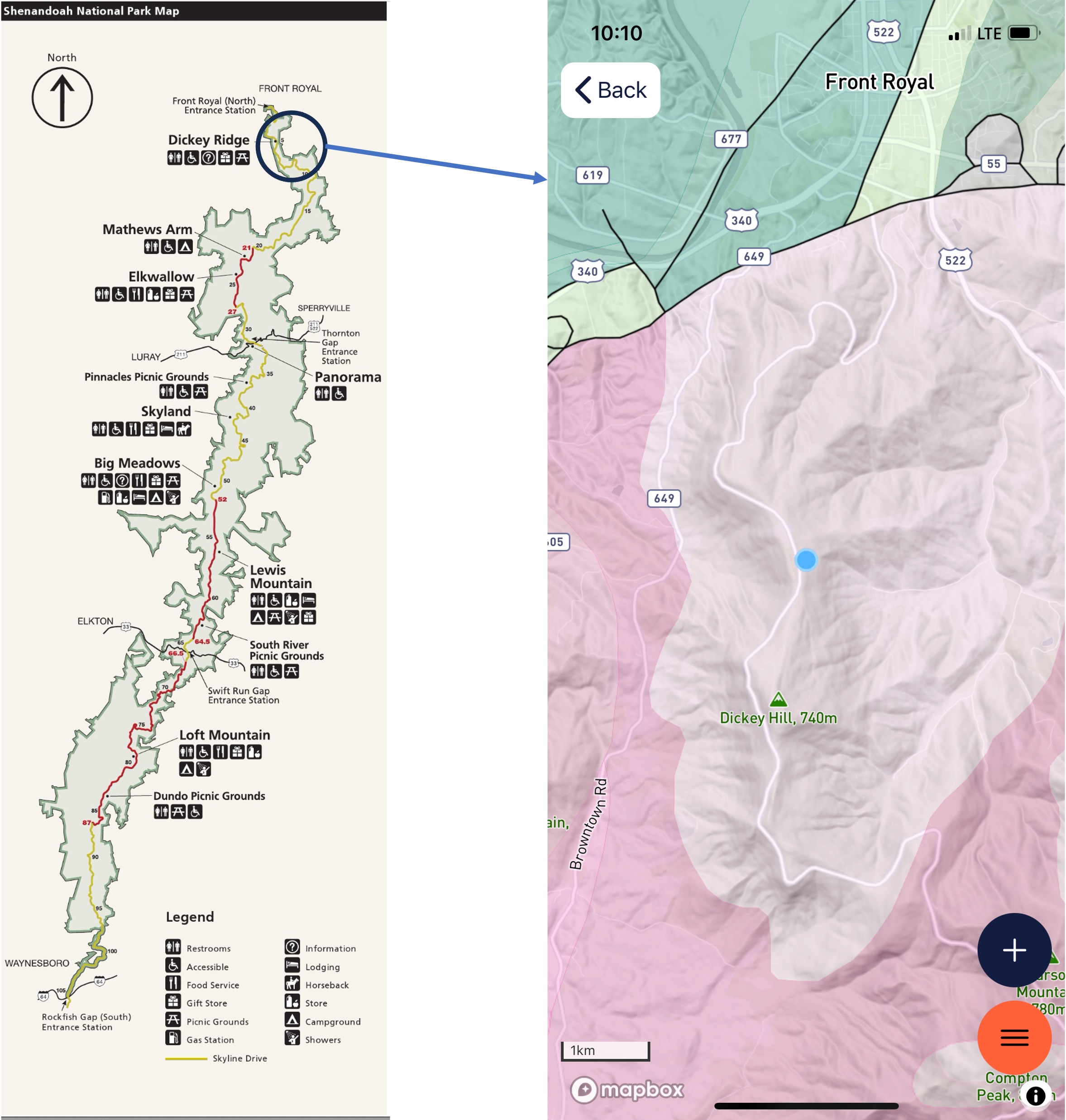
Figure 2. The left image is a map of Shenandoah National Park, which extends along the ridge line of the Blue Ridge Mountains. The study area is circled and a geologic map from RockD is shown in the right image. The blue dot is where we started our climb to Dickey Hill. The rocks of this area (shown in a light-gray color) are the Catoctin Formation (1000 – 485 Ma): metabasalt (metamorphosed to greenschist facies), including some preserved volcanic structures, which are the subject of this post.
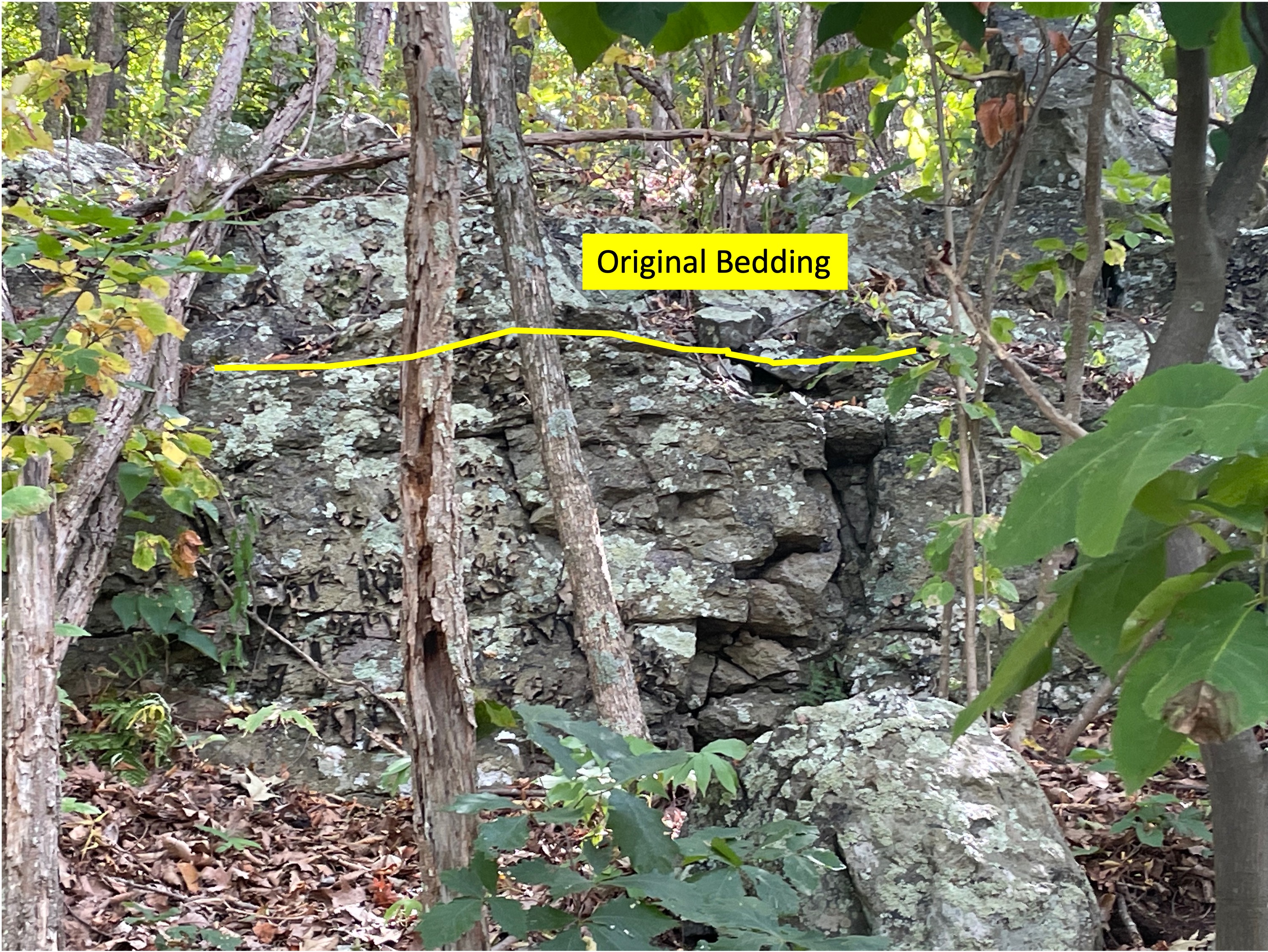
Figure 3. Exposure of Catoctin metabasalts, showing original bedding, which is dipping away from the camera, and variability of these rocks in outcrop.
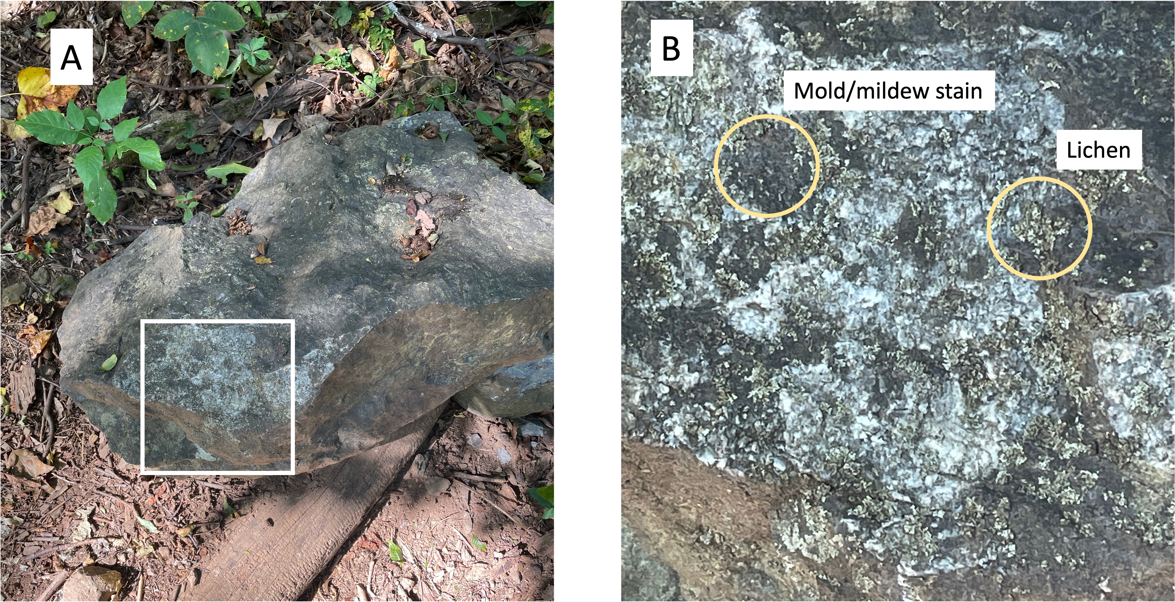
Figure 4. Example of what metabasalts look like in the field. (A) boulder showing a greenish hue that has been roughed up a bit and is no longer angular. (B) Close up of area enclosed in (A), showing some of the biological materials that produce the mottled appearance of these rocks. The bright areas with angular form are probably quartz and feldspar, two minerals commonly associated with greenschist facies metamorphism (low pressure and low temperature).
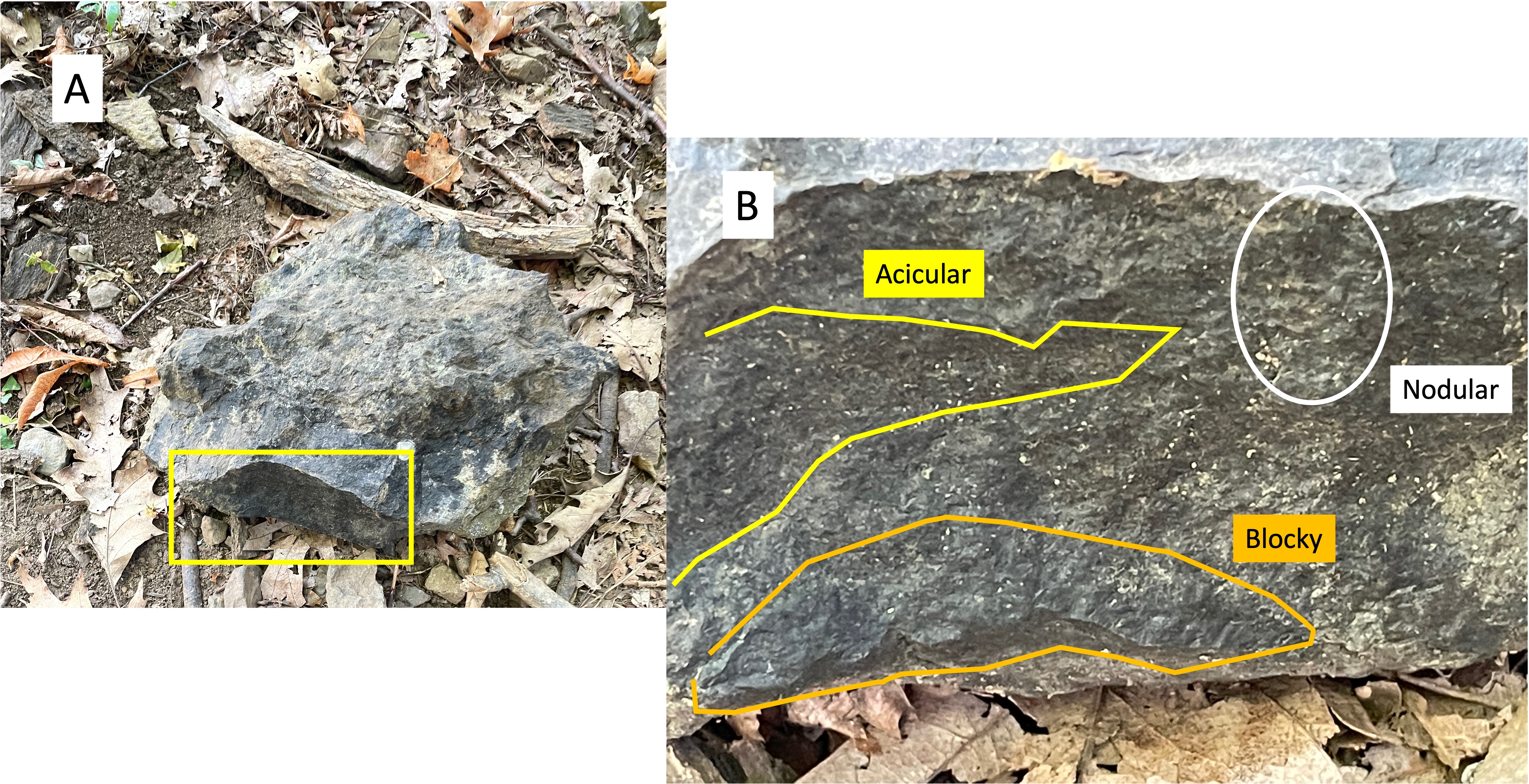
Figure 5. Example of textures found in Catoctin metabasalts: (A) bluish-green boulder with angular form. (B) Close up of fine-scale textures preserved from the original basalt. The acicular sections result from a preferred alignment of minerals, indicating a flow direction; blocky texture indicates that this part of the sample was part of a larger flow and probably more viscous; nodular textures probably result from weathering at some point, possibly soon after deposition. Volcanic flows are not uniform; for example, the basalts of the Catoctin formation are 3000 feet thick but were extruded over tens of millions of years, during which the magma chamber would have changed in composition. These “nodules” are elongate and could be due to recent (last few million years) weathering of acicular textures. Perhaps nodular is the wrong word; these also look a lot like miniature pahoehoe lava, which is ropy when first created.

Figure 6. (A) angular boulder with a rich blue color, suggestive of blueschist facies metamorphism (low temperature and high pressure). (B) Close-up showing ropy, flowing structures around fragments of basalt (originally) that were carried with the flow. We saw this kind of flow structure at Koko Crater on Oahu in a previous post, but those rocks were only a few million years old and hadn’t been buried and subjected to huge tectonic stresses.

Figure 7. Images of volcanic textures in an outcrops. (A) This photo shows a slight difference in texture between the intrusion and the surrounding lava, even though both were erupted at the same time. The lava produced by a magma chamber, especially near the surface, is not homogeneous but rather a poorly mixed assortment of molten and solid material infused with high-pressure volcanic gas. The circled area labeled as a Cavity (speculative) is an example of this heterogeneous volcanic texture. (B) This photo of an outcrop shows angular fragments quite distinct from the background matrix (not to be confused with lichen); these are not original textures because basalt does not contain light-colored rock fragments. These inclusions are metamorphic in origin, probably quartz and feldspar.
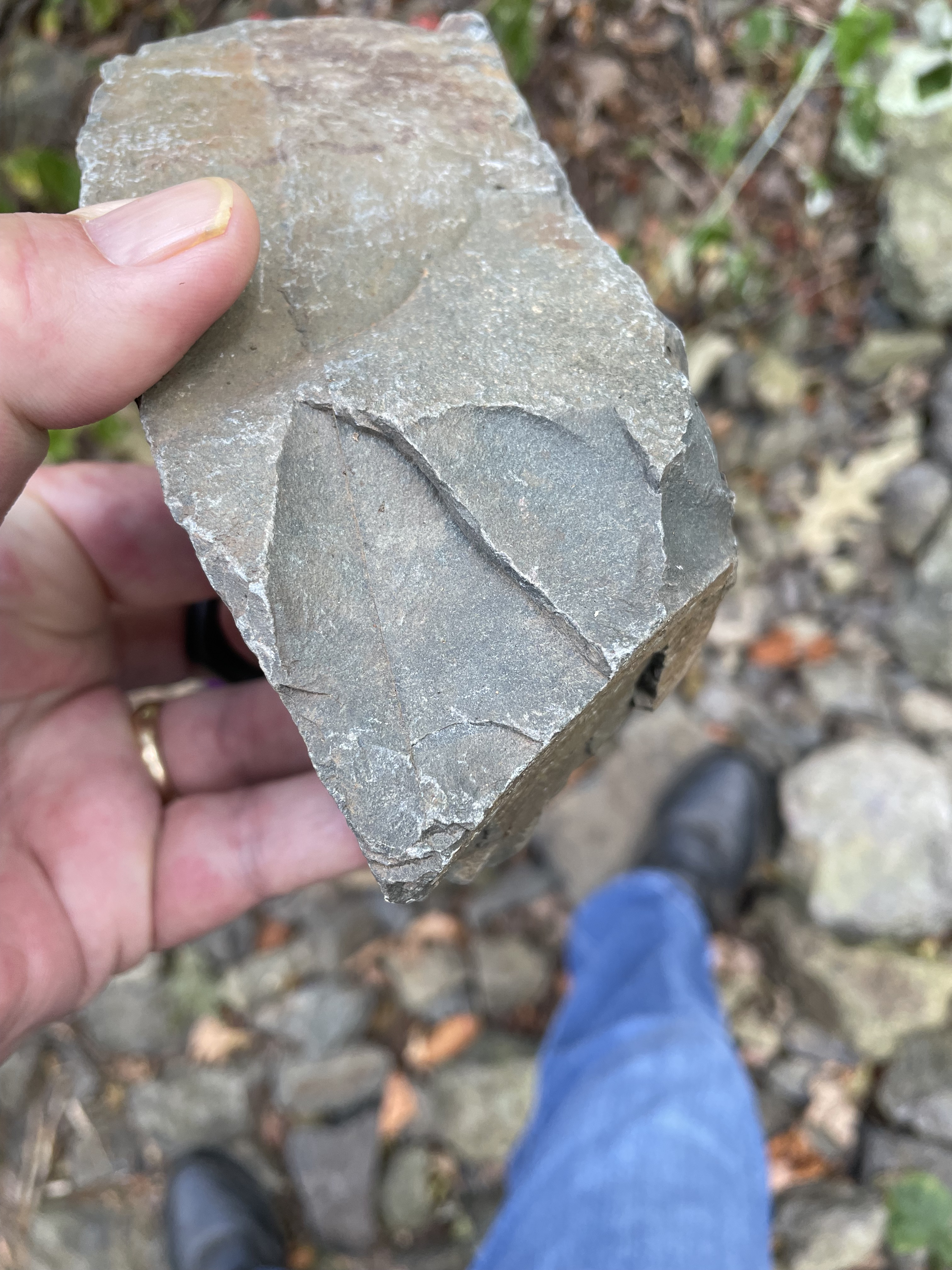
Figure 8. This hand sample was photographed at the top of Dickey Hill. It is as fresh a sample as you can get without a rock-hammer. Note the thin filament of material separating two conchoidal fracture zones. The greenish color is why metabasalts are called greenschist.
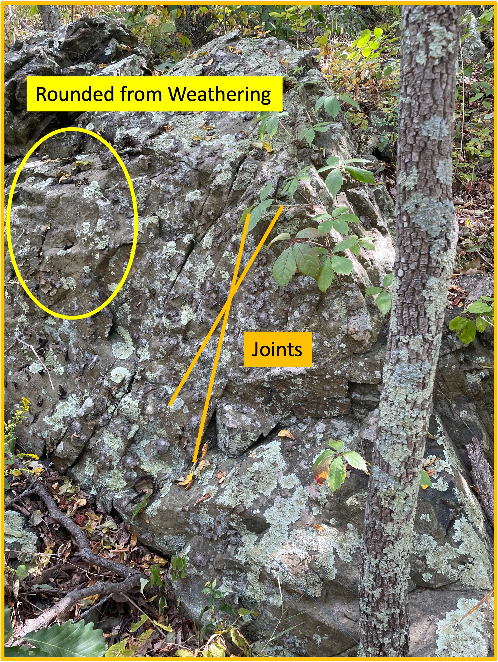
Figure 9. This photo shows a couple of post-tectonic textures that reflect events after these volcanic rocks were buried and metamorphosed. Joints are brittle fractures that occur when a rock has been exhumed and the stress regime has reduced; the rocks break in patterns like the “X” that has been superimposed on this image. Joints cannot be dated so all I can say is that this pattern, which was expressed in all of the outcrops I saw, occurred millions of years after burial, probably after the break-up of Pangea, when the mountains that once overlay this area were eroded away. The circled area shows rounded corners like we saw in Fig. 5B, suggesting that water flowed over this outcrop for a long period of time. The fracturing in Fig. 8 would have occurred during this period of relaxing stress.
SUMMARY. About one-billion years ago, lava flowed onto the land that later became Virginia for millions of years, culminating in a 3000-foot-thick pile of basalt. This is half as thick as the Deccan Traps basalt province in India or the Columbia Plateau of North America; the latter was produced in 10-15 million years. Both of these geologic provinces are associated with collisional tectonic regimes.
The uncertainty in age for the Catoctin Formation (1000-485 Ma) is due to the uncertainties of radiometric dating, caused mostly by loss of radioactive products over time (loss of products gives false young ages); thus, it is probably safe to say that these rocks were originally produced about one-billion years ago.
We saw these rocks at Morven Park and Catoctin Creek, and we saw contemporaneous sedimentary rocks at Bull Run nature preserve. If these basalts are analogous (that’s a big IF) to the Deccan Traps and the Columbia Plateau, this was a collision of tectonic plates. This tentative interpretation is supported by the lack of pillow lava structures (lava erupted into deep water) reported in the Catoctin Formation. The presence of terrigenous sedimentary rocks deposited 500 million years later in Virginia suggests that an entire Wilson Cycle (opening and closing of an oceianbasin) occurred between the Catoctin formation (~1000 Ma) and the Harpers formation (~538 Ma).
The greenschist metabasalts of the Catoctin formation weren’t buried deeply or heated very much, so they weren’t close to the point of impact during the closing of Iapetus Ocean, which was somewhere on the continental shelf a hundred miles or more east of the study area. This tectonic collision began north of Virginia about 550 million-years ago (i.e. when the Harpers formation was deposited). It is called the Taconic Orogeny. The result was the supercontinent Pangea, which lasted several-hundred million years before being torn apart about 200 million-years ago.
Tectonic plates are dancing but who’s playing the music?
Mantle plumes are elusive for humans to track. Imagine a pan of boiling water; bubbles appear, some large, some small, spaced at seemingly random distances apart. They last only as long as it takes them to rise to the surface.
The rocks are trying to tell us what dance they are moving to …
Catoctin Creek: Deep into the Precambrian
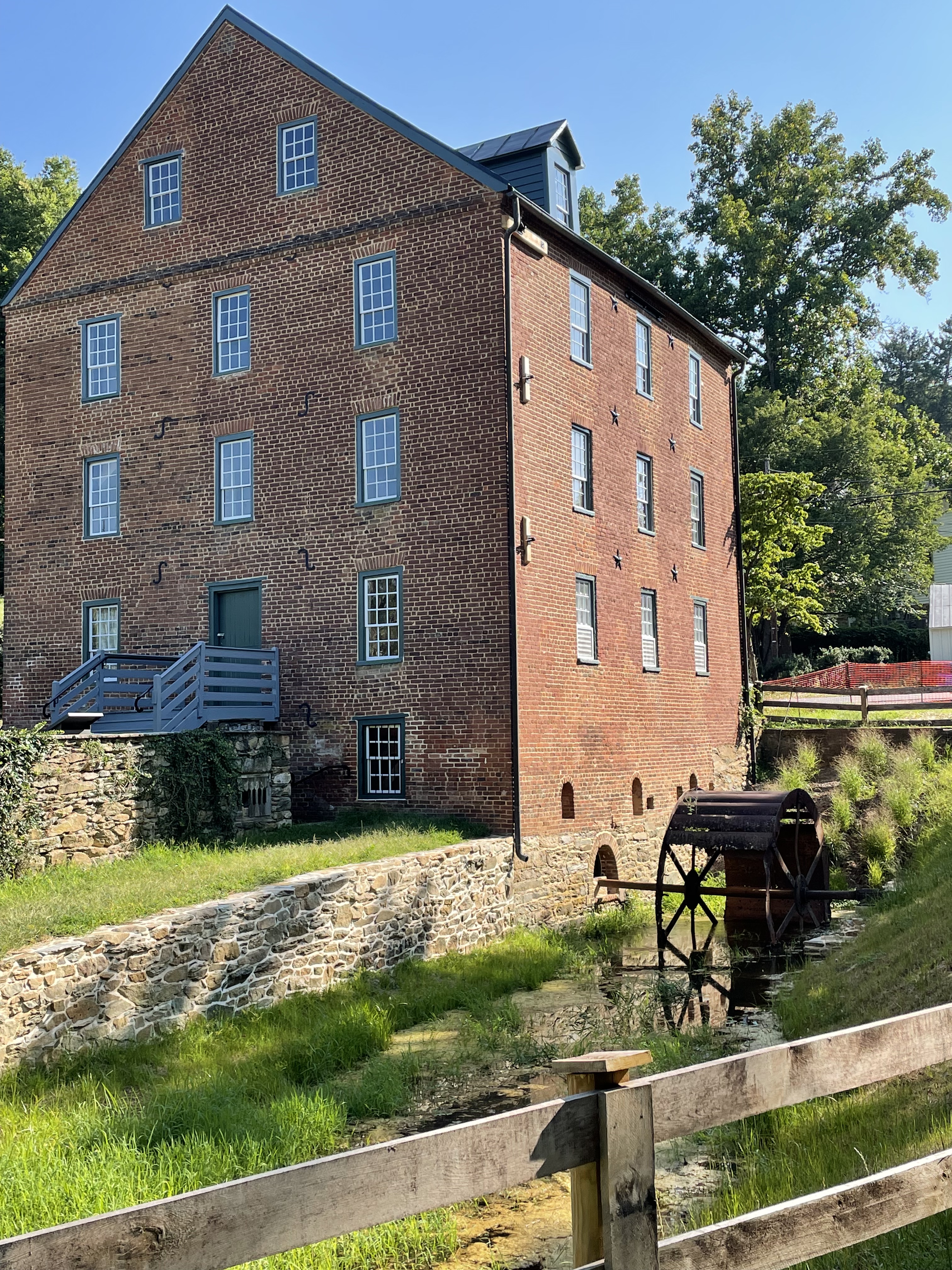
Figure 1. The Waterford mill was constructed in the 1820’s and operated until 1939. It was located along Catoctin Creek because there is a significant drop in stream elevation here. A low ridge behind the mill suggests part of the reason: resistant rocks that produce a series of sudden drops in the stream, perfect for collecting water behind a dam not too far from the mill. The shorter the length of the “head race”, the lower the construction costs. The “tail race” can be seen leading from the waterwheel. This small ditch leads around the facility and drains into Catoctin Creek a couple hundred yards downstream. This post will explore upstream on Catoctin Creek, as far as the mill pond (storage pond for hydraulic pressure), and see what the rocks tell us.

Figure 2. (A) Regional map of the study area. My house is labeled with a star. Bull Run fault is a continuous normal fault that we saw at Morven Park and Banshee Reeks Nature Preserve; its location in the figure is approximate. It demarcates younger Mesozoic rocks to the east from older, Precambrian, rocks to the west; the latter form an elongate ridge that cuts through the study area (rectangle centered on Waterford), as well as the Blue Ridge further west, which front the Shenandoah Valley. Vertical movement along Bull Run fault began about 220 Ma (Ma is a million years, but measured by radiometric techniques) when Pangea was torn apart by the newly forming Atlantic Ocean. (B) Geologic map from RockD of Waterford area. The section of Catoctin Creek discussed in this post is enclosed by a blue ellipse. Note that the Precambrian rocks fall into two distinct sequences: 1.6 Ga (billion years measured with radioisotopes) and gneiss, both metamorphosed; and 1 Ga to 600 Ma volcanics and associated sedimentary rocks. The contact between them is an unconformity but the type cannot be determined from field data. This might be a buried and disrupted late Precambrian (~600 my) thrust fault that pushed older rocks over younger, like we saw at Bull Run Nature Preserve.

Figure 3. (A) View looking downstream along Catoctin Creek, showing rounded cobbles (~2 inches) in a sandy matrix, with silt and mud. This unlikely assortment of sediment grain sizes suggests to me that there are multiple sources being mixed along the creek; for example, rounded cobbles suggest miles of transport along swift-flowing creeks whereas mud is the product of physical and chemical weathering of rocks with a small quartz content (quartz is very hard and chemically stable; i.e. sandy beaches). (B) Exposure of older Precambrian schist along the creek bed, forming a low obstruction. (C) The schist layers (schist is a fissile rock) present a weathered appearance; chemical weathering produces mud in-situ without bedload transport, producing few cobbles.

Figure 4. Examples of different rock types found along Catoctin Creek. (A) Collection of angular schist boulders (~one foot in size) at one of the tributaries to the main stream. (B) Quartz intrusion, probably from the oldest rocks (metamorphosed granites and gneisses). The sample is about one foot long. (C) Fresh surface of the schist, showing fissility and a sheen associated with lower-grade metamorphosis, such as in phyllite. This sample was several feet long and had been transported to the mill-pond dam during construction of the mill.
Figure 5. The dam constructed to retain water for Waterford mill contains a variety of large boulders, but the majority were schist (see Fig. 4C). I didn’t see any granite or gneiss, which isn’t surprising because these large stones would have been difficult to transport in the early nineteenth century. They used what was readily available; the exposure of schist along the creek bed (Fig. 3A) suggests that the ridge fronting the mill (Fig. 1) was a likely source of material; after all, rock had to be removed to build the mill and the town of Waterford.
SUMMARY.
More than 1.5 billion years ago, something was happening in Loudon County, Virginia, long before there were multicellular organisms (eukaryotes) or even land plants. There was a collision of tectonic plates massive enough to produce granite and gneiss (high-grade metamorphism) and then deform these very durable rocks.
Four-hundred-million years later, an episode of extreme volcanism occurred and thick sequences of basalt and volcaniclastic sediments were laid down in Loudon County at about the same time (give or take a hundred million years) as deeply buried shales were being transformed into schist at several locations along the eastern margin of modern North America: less than 50 miles from Waterford, at Great Falls; what would become New York City; and Vermont. This was the closing of Iapetus, which took hundreds of millions of years and stretched for thousands of miles, creating Pangea and the rise of eukaryotes, fish, amphibians, reptiles, and mammals, not to mention land plants.
About two-hundred-million years ago, Pangea was torn apart and grabens formed, filling with sediment eroded from the surrounding elevated terrain. These sedimentary rocks are found east of Bull Run fault (Fig. 2A) where they remained protected from the elements (chemical and physical weathering) while the older rocks were elevated to form mountain peaks in the modern world and eroded into boulders, sand, and mud.
Two-hundred-million years later, the shattered remnants of a once-majestic mountain range, stretching from Canada to the Gulf of Mexico, comprise its core of metamorphic and igneous rocks recording events we can only speculate about today.

Recent Comments