
Cretaceous Intrusive Rocks in British Columbia
This post finds me in British Columbia (Fig. 1), where I explored fjords cut into mostly intrusive rocks that form an immense batholith composed of many overlapping plutons. The tectonic regime of this area is collision between the many small plates that comprised the Pacific Ocean as well as any island arcs and microcontinents that got in the way of N. America on its westward journey, which began about 200 million years ago (Ma). A collision between ocean crust and the N. American tectonic plate would have created a subduction zone, in which the denser ocean crust was driven beneath the continent. However, recent work suggests that this process was interrupted for uncertain intervals when islands collided with N. America; furthermore, there is evidence for a lot of strike-slip fault movement along transform faults. You can learn more about this complex history at Nick Zentner’s web page.
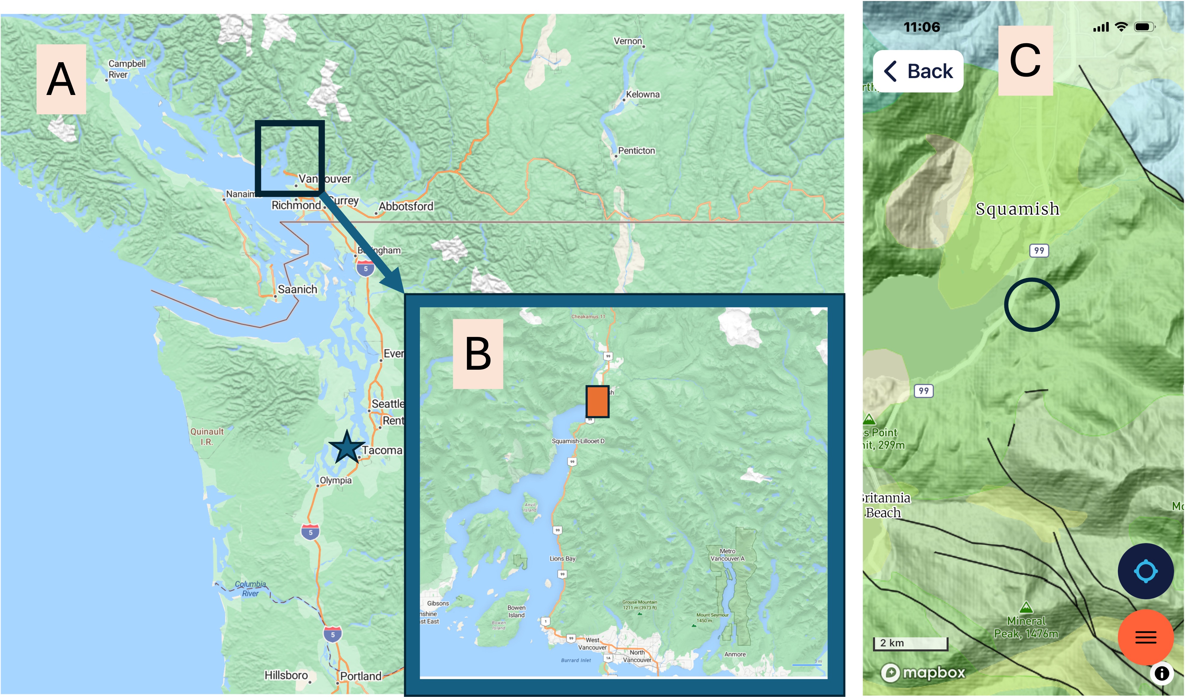
Figure 1. (A) Regional map showing the location of the study area in SW British Columbia, about 230 km (140 miles) north of Tacoma (starred location). (B) Detail map of the inlet (I couldn’t find a name for it), showing the location of the Sea-to-Sky gondola I rode to Squamish and Chief Viewpoint park. (C) Geologic map from RockD, showing the fairly uniform occurrence of diorite intrusive rocks intruded between 143 and 66 Ma (covering the entire Cretaceous geological period). The town of Squamish sits at the head of the fjord. Faults of unidentified type (i.e., normal, reverse, strike-slip) are common but don’t appear to control the location of major drainage basins, which have been excavated by glacial action during the Pleistocene epoch. The circle indicates the area reported on today, except for Fig. 2.
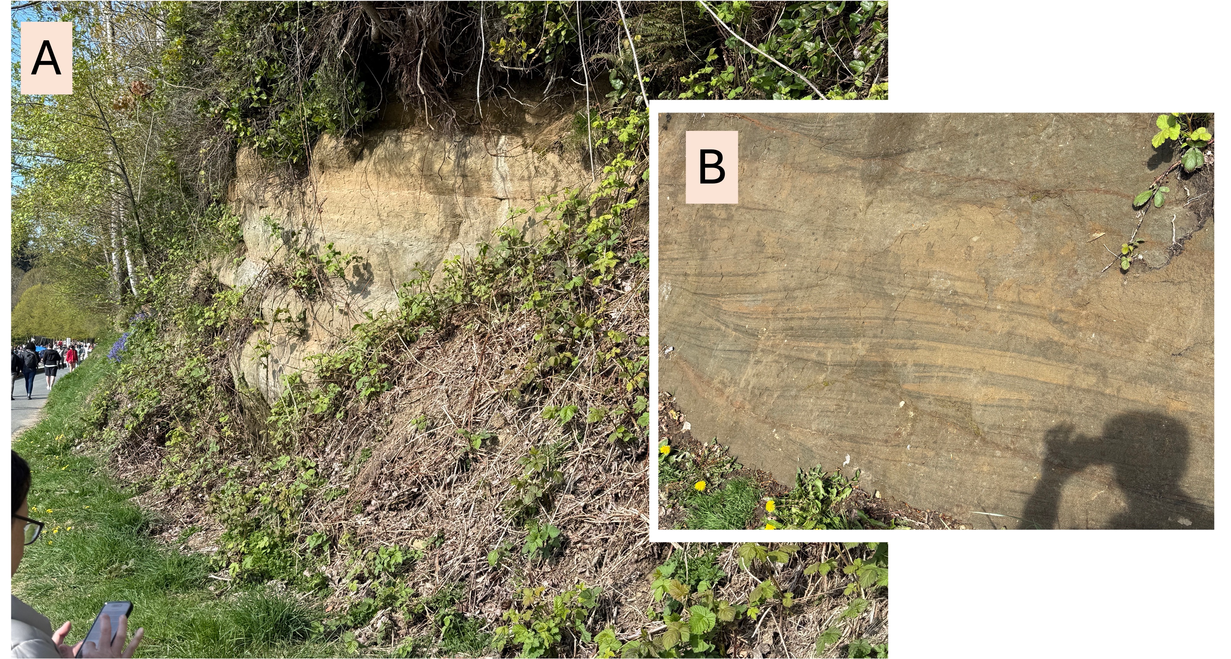
Figure 2. (A) Exposure of Late Cretaceous (100-66 Ma) sedimentary rocks at Stanley Park (bottom center of Fig. 1B). These rocks look unconsolidated, but they are actually well cemented. (B) Close-up showing lamination and sets of unidirectional cross-bedding, which indicates transport in a stream rather than a marine environment. Transport was generally to the left, but each set of cross-beds is a slice through a three-dimensional form like the bars seen in modern rivers.
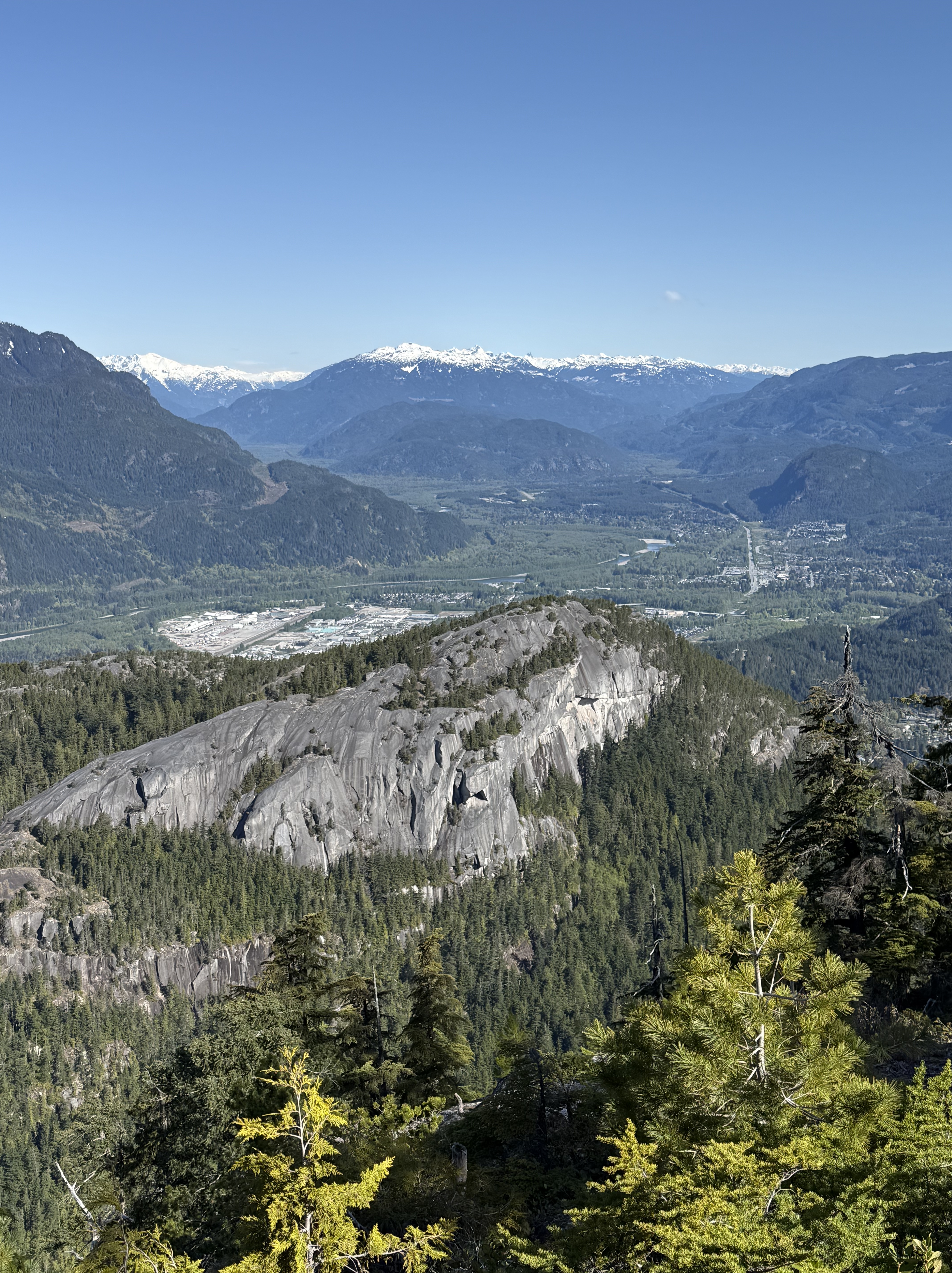
Figure 3. View looking northward from Squamish and Chief Viewpoint park (circled in Fig. 1C). Besides offering a breathtaking view of the northern Rocky Mountains, this photo reveals several interesting geologic phenomena. The small peak in the foreground is solid diorite that was intruded between 143-66 Ma more than 20 km beneath the surface at that time. It has been uplifted as overlying rocks were removed by erosion. It may represent a single intrusive episode because typical plutons are 2-3 km in diameter; batholiths comprise multiple intrusions spanning millions, if not tens of millions, of years. Note the lineations running up the side. These reflect the scraping action of ice sheets during the last two million years as they flowed towards the sea. The valley in the background is the classic U-shape caused by the advance of glaciers. It has been filled in by glacial deposits very similar to those found in NW Washington. Glaciers in this area originated locally and were up to several kilometers in thickness. They flowed both towards the sea and inland to form a continental glacier.
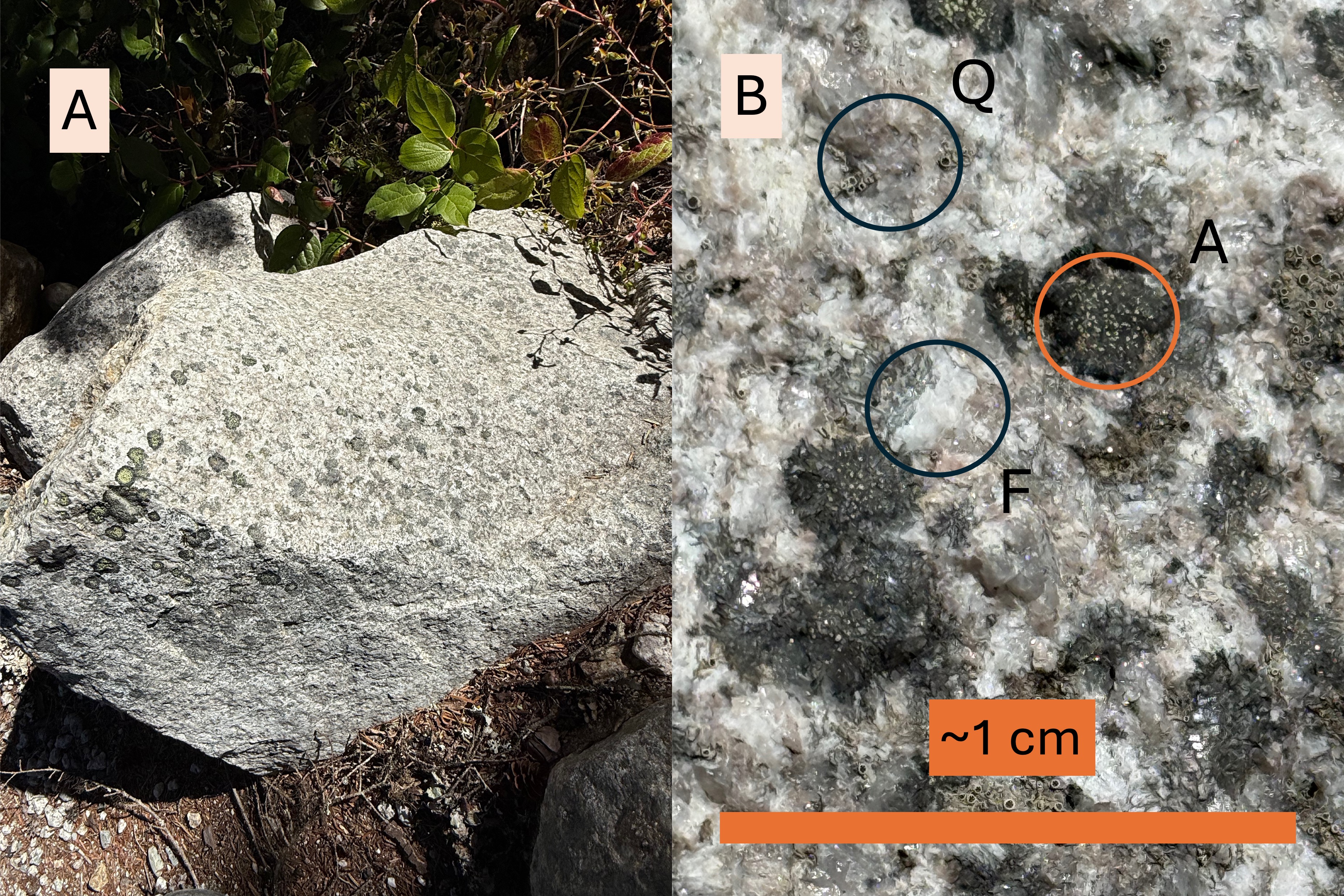
Figure 4. (A) The rocks within the park are fairly uniform in composition because they were intruded as part of a single pluton. This boulder shows the typical salt-and-pepper appearance of dioritic rocks. This sample is relatively fine grained, which indicates that it wasn’t emplaced more than a few tens of kilometers deep; i.e., smaller crystals indicate faster cooling which occurs nearer the surface. (B) Close-up at the highest optical magnification available on my phone, about 5X. RockD generally describes the igneous rocks from this area as granodiorite, a type of diorite that contains 20-60% quartz (labeled Q in the photo), and primarily feldspar (labeled F) that contains sodium and calcium with little potassium. The dark minerals are amphiboles (labeled A), probably hornblende. These are typical granitoid rocks from a subduction zone.
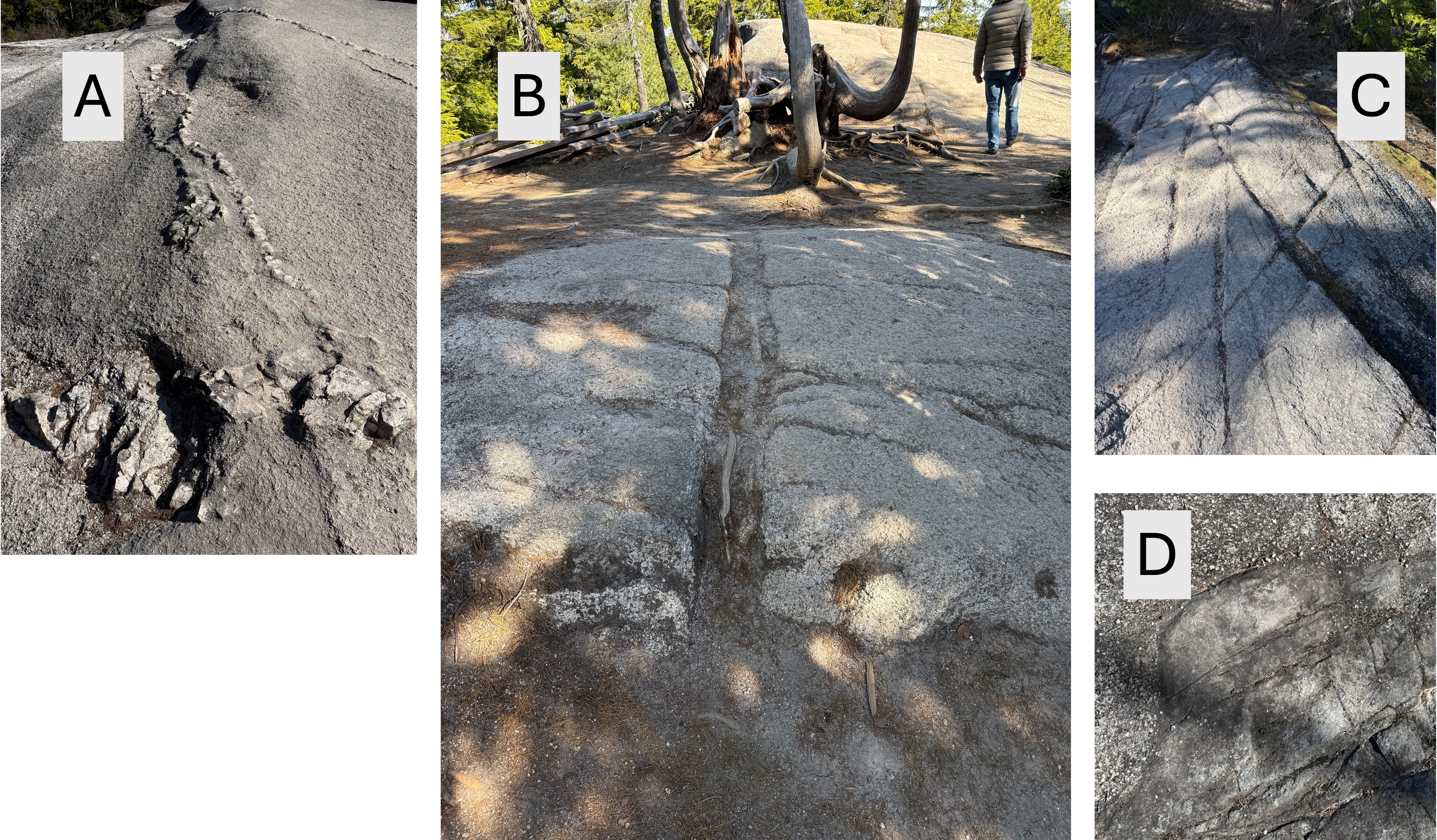
Figure 5. (A) Surface showing a vein filled with a harder mineral that is probably quartz. The softer feldspar and hornblende has weathered more easily and been removed by the scraping of ice sheets containing rocks. Note the irregular shape of the vein; minerals like quartz have the lowest temperature to solidify and fill cracks in the slowly cooling magma. (B) This vein is straighter than that in A and is filled with minerals that have weathered more than the main rock. (C) This photo shows joints (X pattern in the center of image) and lineations (top to bottom) that indicate ice moving over the surface with embedded rocks that scratch the exposed rock. (D) This image shows a finer grained material filling a void in the original magma. The pebbled appearance of the coarser material results from preferential weathering of minerals like hornblende and feldspar. These images imply that the magma had solidified sufficiently to form joints as it cooled, but was then injected with more fluid. This isn’t surprising in a region where so many plutons were being created; there was certainly a lot of overlap in their intrusion.
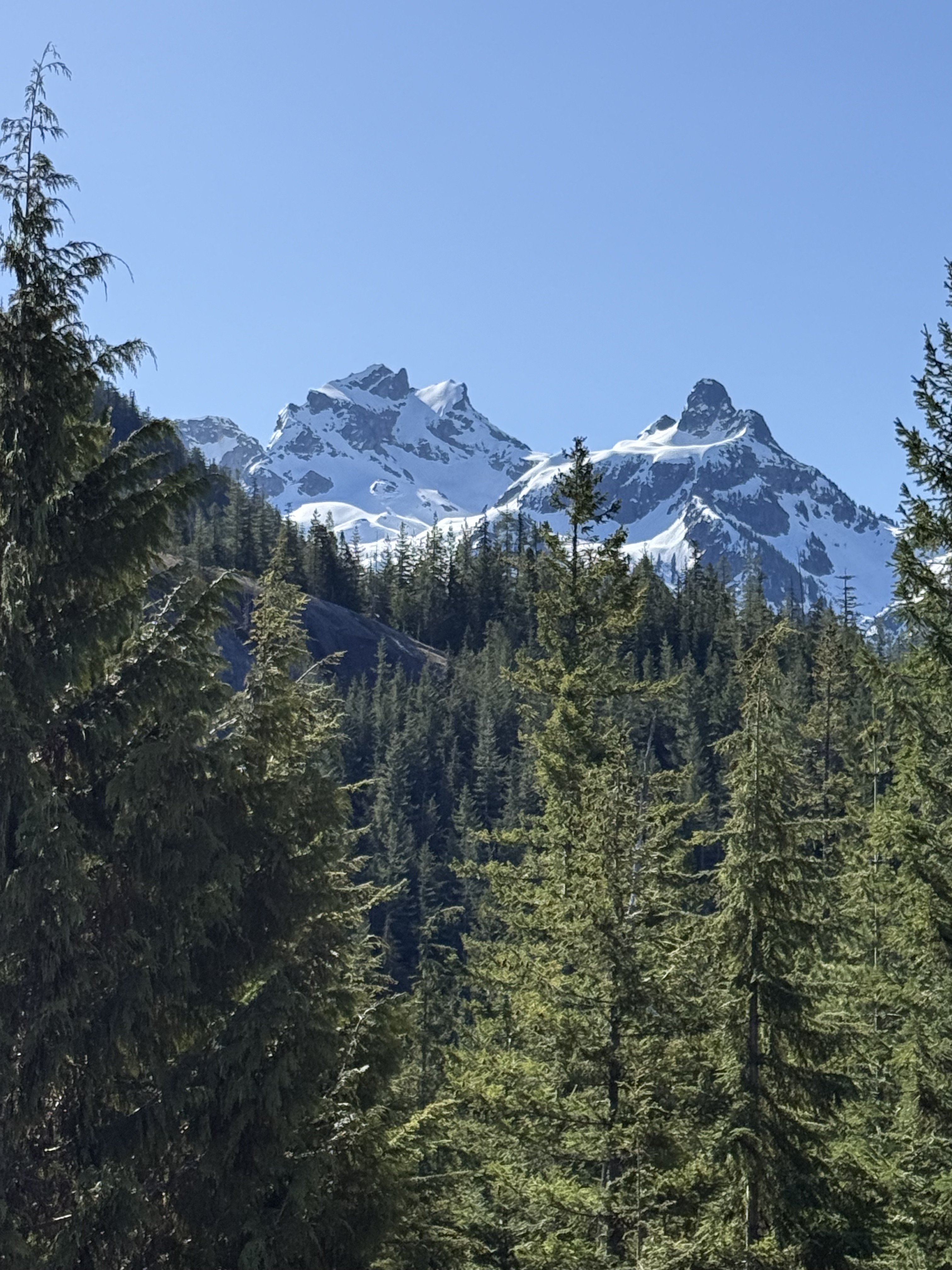
Figure 6. This final photo shows two pointed peaks that result from ice cutting away at any rock that protruded above the main surface. Remember that the ice was up to three kilometers thick here whereas the peaks are less than two km above sea level. It is hard to imagine that much ice.
SUMMARY
This post describes only a small part of one pluton of the hundreds exposed within the Northern Rocky Mountains in British Columbia. The scale is difficult to visualize, but they represent only a tiny fraction of the immense volume of oceanic crust that was subducted beneath the nascent west coast of N. America during the Cretaceous period. Nevertheless, what we’ve documented shows that this was a continuous process that lasted almost 70 million years. And it is continuing to this day, as evidenced by volcanism within the Cascades Range of Washington, Oregon, and N. California.
Deep igneous intrusion doesn’t necessarily create volcanoes, however; surface eruptions occur when magma is emplaced at shallow depths, which was probably not the case for these rocks from the Cretaceous. We can’t know for sure because so much rock has been removed by wind, water, and glaciers during the uplift of these intrusive rocks, from tens of kilometers beneath the surface.
Even if our picture of the earth’s history in the Pacific Northwest is incomplete and mysterious, it is awe inspiring to look back in time and deep within the crust.
And it isn’t science fiction…

Recent Comments