
First Look at Ireland: County Limerick
Here I am on the other side of the Atlantic Ocean, seeing what the rocks say from this side of the still-expanding sea that split Pangea in two, creating North America and Europe. I have written a lot about the long-lasting collision of land masses during the Neoproterozoic and Paleozoic eras in many posts from Northern Virginia (NOVA) and surrounding areas, but only from the perspective of North America.
Jumping ahead a little, after hundreds of millions of years of tectonic stability (geologically speaking), the earth’s crust fractured about 200 million years ago and another Wilson cycle began.

Figure 1. View of Loch Gur near the city of Limerick. Such irregular, often deep, lakes are common throughout Ireland and Scotland. They are the product of extreme glaciation; thick ice sheets shaped the topography in ways unrelated to erosion caused by rain and river transport of sediment. To get to the bottom line, we have to first recognize the discontinuity between the topography and the geological history of the area.
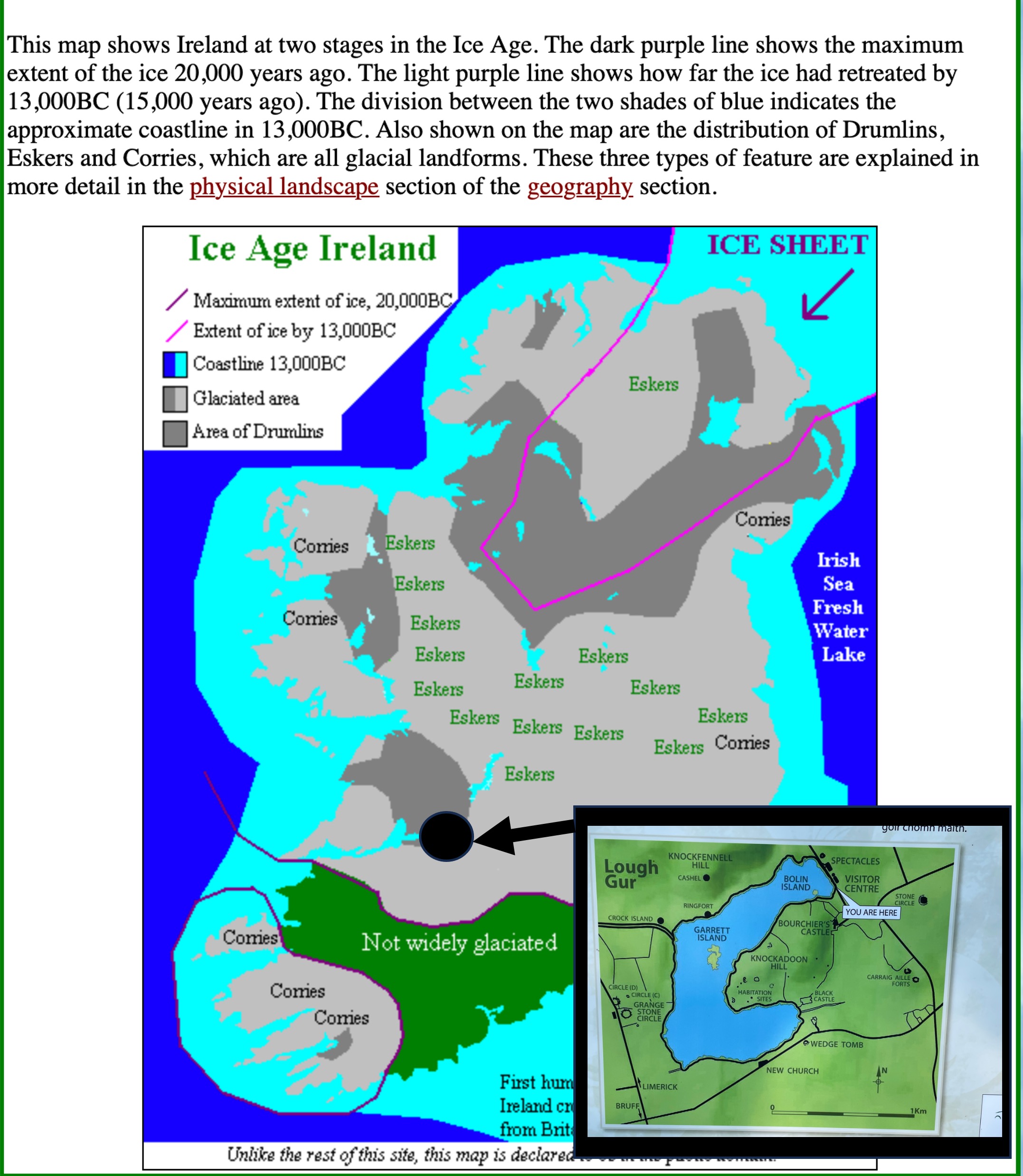
Figure 2. Ireland was almost completely covered by ice, almost a mile thick at times, which didn’t melt until about 15,000 years ago. The study area (inset map) is located SE of the end of the Shannon Estuary, in a region that contains drumlins; however, the hills seen in Fig. 1 are not unconsolidated glacial till, but instead limestone which is the bedrock of this region. Eskers are similarly unconsolidated glacial debris deposited by rivers that run under the ice, carrying away meltwater and sediment. Corries, on the other hand, are what North American geologists call cirques; these are semicircular basins carved out where glaciers form and expand outward. Loch Gur fits this geomorphologic model from its shape and the lack of depositional glacial features.
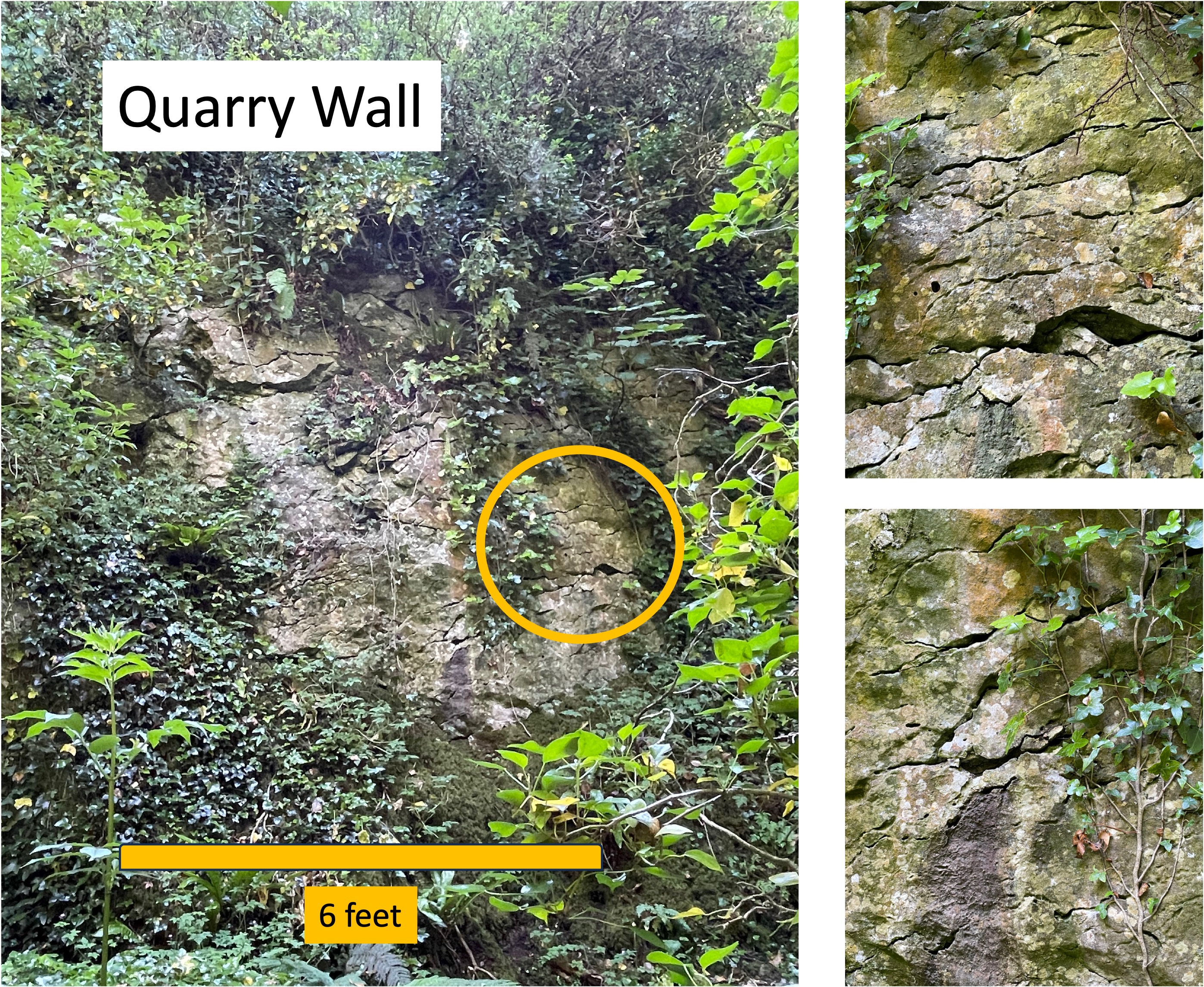
Figure 3. Images of quarry face along south shore of Loch Gur (see Fig. 2 for location), showing dissolution along fractures and bedding (inset photos). This process, if it continues, can lead to the development of karst features such as sinkholes and caves. This doesn’t seem to have occurred in the study area however.

Figure 4. Details of limestone boulders from Loch Gur. (A) Highly weathered block at the current shoreline, showing preferential weathering of dark areas. (B) Dark areas like those in Panel A were present throughout large boulders (> 4 feet across) lying loose at the foot of the quarry cliff. (C) A close-up reveals a difference in grain size between the dark and the light areas. The dark zones may be concentrations of contaminants (e.g., clay) or the product of partial recrystallization with contamination by ground water after deposition. Comparing (B) to (A) suggests that the dark areas chemically weather faster when continuously exposed to water (panel A was beneath the water line until recently). I think (microscopic analysis would confirm this) that the dark splotches contain more clay, a mineral group that weathers faster than most other minerals. The dissolution seen in Fig. 3 may be a completely different process, however; chemical dissolution accelerates in limestone where rainwater is concentrated along fractures (as opposed to clay weathering on exposed surfaces, as suggested by this figure). In summary, I think these limestones were deposited in a shallow-water area with a high inflow of clay minerals, which migrated during diagenesis to form the dark splotches. These carbonate rocks weren’t buried deeply enough to melt and become marble, a metamorphic process that would have removed the contaminants.

Figure 5. One of the many hills present within the study area. This one is capped by a prehistoric site encircled by a stone wall. The limestone to build the original wall and houses was quarried from the hill, which produced the low cliff seen in this image. Other exposures were exploited further down the slope to expand the settlement.

Figure 6. Prehistoric quarry showing thick bedding of the upper layer of sandstone and the thinner bedding of the lower layer (seen in the foreground, partly covered by grass). Any fossils contained within the limestone were destroyed during burial; however, the lack of any macrofossils from these rocks, which were deposited between about 360 and 320 my ago, suggests that they weren’t in the most favorable of environments for shellfish.

Figure 7. Geologic map of County Limerick. The study area is encircled by a ring of Carboniferous volcanic rocks (dark blue), which suggests that there was igneous activity (associated with orogeny) between 360 and 320 my ago, on the east side of the tectonic collision zone; the outcrop pattern suggests that a magma chamber was venting through a caldera. I didn’t see any evidence of the timing of this volcanism, so it may have been into unconsolidated sediments or later, when they were lithified. The limestone we saw in Figs. 3-6 is indicated by the light-blue areas on this map. As a side note, there is a 4500 year-old stone circle (Grange Stone Circle) at the western limit of the dark blue ring; it contains large blocks of volcanic breccia that I couldn’t identify in the field, because all of the blocks comprising the prehistoric circle were weathered to the same gray color. The identification is from a detailed archaeological map of the site that I did not photograph.
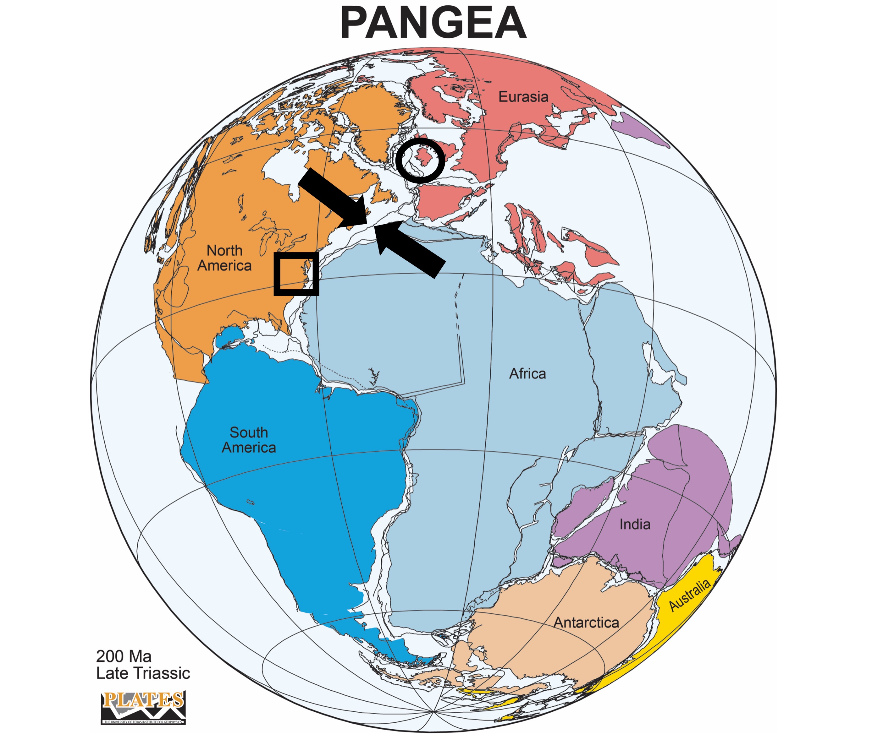
Figure 8. Reconstruction of Pangea about 200 my ago. The arrows indicate the collision of two tectonic plates. The square is where I have been reporting from NOVA; the circle is Ireland, where I am reporting now. Note that the two areas are offset by more than a thousand miles along the suture zone.
Comparison to North America. The rocks in the areas I have reported on in NOVA (square in Fig. 8) are either from the late Proterozoic eon and early Paleozoic era; or from the Triassic period, which is the time represented in Fig. 8. The Lower Carboniferous period (about 360 – 320 my)falls within a hiatus of more than 300 my in NOVA. Cambrian sediments were deposited unconformably on Proterozoic volcanics about 540 my ago there — the youngest being conglomerates exposed at Weverton Cliff.
The limestones exposed at Loch Gur were deposited in quiet water during this hiatus, which represents mountain building and subsequent erosion. The lack of evidence of this orogeny in NOVA while carbonate sediment was accumulating in Ireland makes sense because the latter was far removed from this Neoproterozoic/Paleozoic mountain range.
However, when we look further to the west and north from NOVA, we find thick layers of shale, sandstone, limestone and even coal beds; the states of Pennsylvania and New York reveal this orogeny in a continuous sedimentary sequence that contains rocks like those we’ve seen thus far in Ireland. I have reported on those in a previous post.
It is the nature of orogeny that crustal upheavals don’t leave direct evidence because high mountains are eroded by water, and produce a blanket of sediments in an immutable process.
We’ll see what else the Irish rocks have to say about that …

Trackbacks / Pingbacks