
Australian Capital Territory: The Great Dividing Range
We are on a quick trip to Canberra the capital of Australia located in the Australian Capital Territory, which is analogous to Washington DC, but it’s called the ACT for short. It’s about halfway between Melbourne and Sydney, in the state of New South Wales. I’m doing the post a little different this time. This is the first post. I may update it to keep the information all together, or I may make a separate post. I don’t know yet.
We’re going to start in the present. Figure 1 shows what the Paleozoic orogenic belt we will be examining looks like today. The figure was taken from the Telstra Tower, sitting atop Black Mountain on the outskirts of Canberra, looking to the NNE. We’ll be heading that way in our next post.
 Fig. 1
The rocks from this area are dated between 485 and 407 million years ago (Ma). The oldest rocks are greywacke, deposited in the ocean from a rapidly rising landmass (labeled D in Fig. 2A). The youngest are rhyolite tuff and associated volcaniclastic sedimentary rocks (labeled C in Fig. 2A). That’s a long time span, but it gives one an idea of how slow geological processes occur. However, these rocks record an orogeny in its entirety, from the first sediments deposited from rapidly rising and eroding mountains, to the emplacement of plutons and volcanism. Of course, it’s difficult to identify the exact date an orogeny begins or ends; after all, when does an orogenic belt become an eroding mountain range?
A geologic map of the area (Fig. 2) shows the complex geology associated with an orogeny lasting more than 70 million years.
Fig. 2
 A
A
 B
B
Figure 2A covers a larger area and indicates some potential locations to examine as well as several common rock units. Figure 2B is a closeup map of the Canberra area. (Note that rock units do not use the same references in Figs. 2 A and B.)
There are many recognized field sites in the ACT and they are listed with descriptions and access instructions in a publication of the Australian Geological Society.
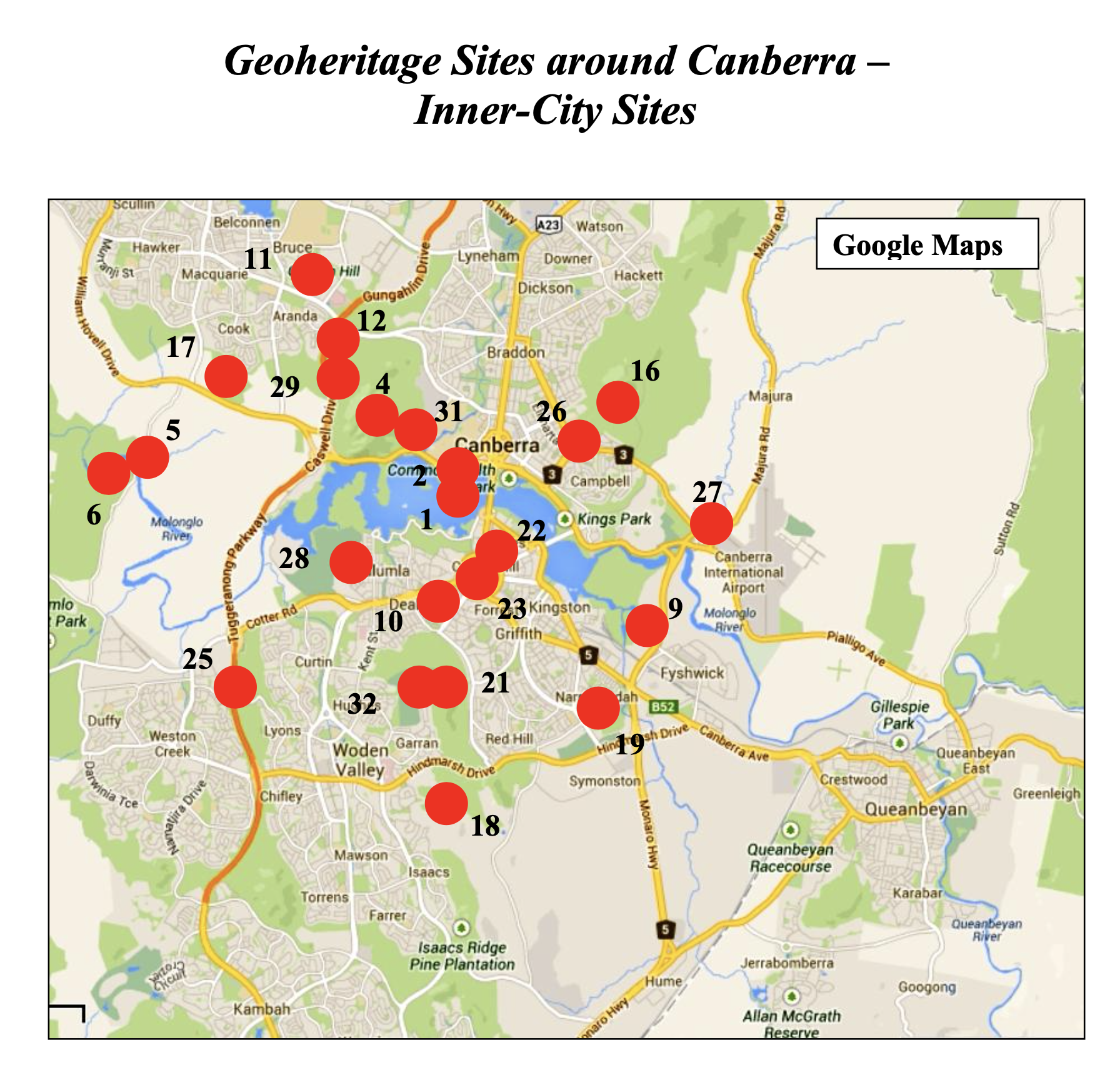
The numbers on Fig. 3 refer to site numbers, each of which has a separate document.
Fig. 3
 A
A  B
B 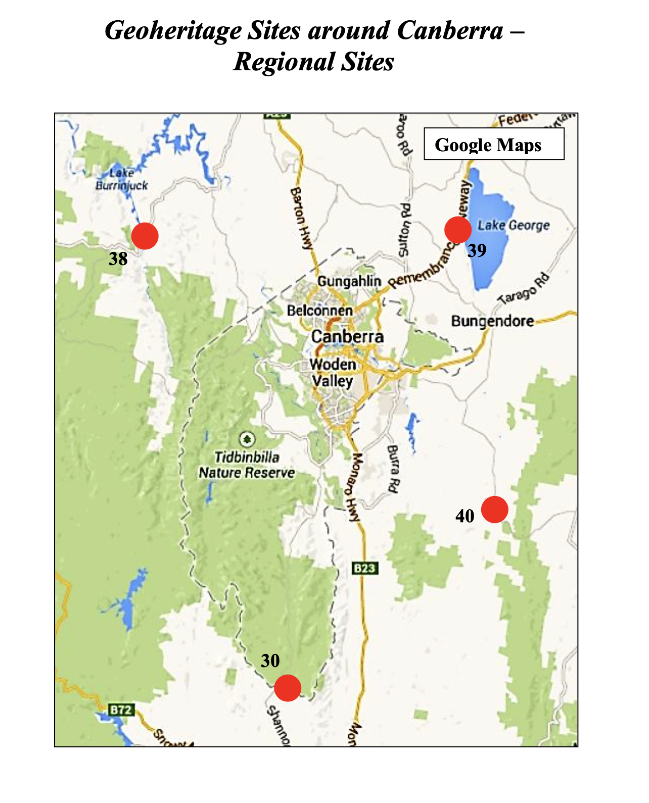 C
C
We’ll be visiting several of these locations on Friday and Saturday.
39 – Lake George: Late Ordovician (485-443 Ma) quartz turbidite and black slate (Adaminaby Group). Silurian (~420 Ma) turbidites, volcanics, and granite.
04 – Black Mountain: Siliciclastic sequence (443-427 Ma); proximal flysch sequence.
00 – Canberra: Canberra Formation (443-427 Ma): Mudstone, siltstone, minor sandstone; dacitic ignimbrite; volcaniclastic sediments, ashstone. State Circle Shale/Black Mountain Sandstone (443-427 Ma). (This is a shared post with 04 but in a different location, which is not in the guide book.)
16 – Mount Ainslie: Mount Ainslie Volcanics within the Hawkins Volcanic Suite; erupted 428-424 Ma.
26 – War Memorial Conglomerate: Dacitic agglomerate within the lower part of the Ainslie Volcanics (428-424 Ma). The agglomerate is composed of angular clasts of greyish dacitic tuff.
10 – Deakin Anticline: A well developed anticline, with a fault between two rock outcrops in volcanoclastic fine sandstone and siltstone of the Yarralumla Formation (424-423 Ma).
31 – Botanical Garden: A conglomerate formed on an alluvial fan, thought to be of Pliocene (2-3 Ma).

Trackbacks / Pingbacks