
Coastal Geology: Uniformitarian Principles
The hectic pace of the last few posts is going to lighten up a little today. Not because there’s nothing going on; rather, there’s so much going on, spanning all of geologic time (the history of the earth), that we have to turn to general principles to stay on track.
I’m going to get a little philosophical here and talk about a basic tenet of geology: Uniformitarianism (yes, another ism) posits that chemical and physical processes have remained constant throughout earth’s history. Apparent irregularities are due to changes in past physical and chemical environments that we are unaware of; physics has not changed. For most classical geological processes, this means that we know more about the past than the present, even if in a somewhat static way.
One subdiscipline in which this is not the case is sedimentology, and other process-based disciplines that study processes that operate at standard pressure and temperature (e.g. 68 F and 1 bar used by NIST); I’m referring to things we can see with our eyes. Touch and not get burned or crushed.
For example, previous posts have discussed metamorphism and the ductile/brittle deformation of sedimentary rocks, without a shred of observational evidence that such processes exist. We haven’t seen any of these processes in action — not enough to convince a skeptic anyway. We extrapolate to geological scales from laboratory experiments or theory, but we are prevented from observing these processes directly by spatial and temporal constraints beyond our control.
For the record, I think geology is founded on a robust theory that is continuously tested with observations, and updated to reflect what is being learned as our observational skills improve.
The sedimentary rocks we examined in previous posts were originally deposited in familiar modern environments, like nearshore marine and rivers/lakes. Thus they look just like sands and muds we can examine in modern depositional environments, right down to the ripples and organisms found in them. The principle of uniformitarianism also applies to regional and global scales; in other words, we shouldn’t expect to find the same depositional environments in modern Tasmania that existed in the past.
For example, most of the sedimentary rocks we’ve examined were part of thick sequences, sometimes miles thick, representing the erosion of large mountain ranges. As fascinating as the mountains of Tasmania are, they are less than 5000 feet in elevation. Furthermore, the rivers are small and carrying very little sediment, so neither sand nor mud are being delivered to the ocean. In other words, there are no swamps, wetlands, barrier islands, lagoons, river deltas, or any other coastal areas like in the northern Gulf of Mexico, the Bay of Bengal, or other areas with high sedimentation rates. What do we find instead?
Figure 1 shows a typical pocket beach/bay from the east coast of Tasmania, not very far north of Hobart (see Fig. 2 for location). The beach face is rather steep because of the coarse sand available (larger sand grains form steeper slopes). The beach is missing something, however; there is no berm at the top, even though the tidal range is about 3 feet here. This is like the beach in a lake.
 Fig. 1
Note that this location is in a small bay with a restricted mouth, which prevents most waves from entering. There is a small, tidal-dominated river that supplies no sediment. There isn’t even a bar at the mouth of the river.
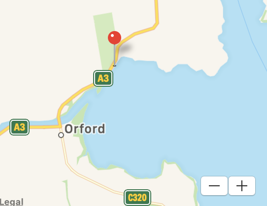 Fig. 2
Figure 3 is an aerial photo of Orford Bay from Google Earth.
 Fig. 3
This image reveals that the river was filling its estuary with sand, the beach propagating seaward, until the supply of sediment was exhausted, leaving a small bay. There has been very little sediment deposited after the groins were constructed at the river mouth.
Can we use the principle of uniformitarianism to apply what we see at Orford Bay to the sedimentary rocks we’ve encountered so far on our journey? The physical processes controlling erosion and deposition (i.e., waves, tides, currents) were present in the past but operating under different conditions. For one thing, Tasmania was not an island but part of a larger landmass; in fact, most of the area was under water and receiving sediment from adjacent land through much of geologic time. That’s why there are marine sediments mixed with volcanics in the older rocks we’ve examined. Nevertheless, we saw nearshore marine features in the Proterozoic rocks discussed in a previous post, which contained thin beds of mudstone intercalated with sandstone, as well as cross-bedding.
We can’t apply what we see here to the scale of rock sequences, however, because there is no active deposition occurring at Orford Bay. There will be no record of Orford Beach in the geological record because the sediment is relict; any particles in this area are being shuffled around endlessly, perhaps slowly moving offshore. There will be no future Orford Formation, the individual particles we see on this beach instead being dispersed as part of a larger layer of sediment created by weathering of igneous rocks within the region. However, as with any sediment, the destiny of this tiny, starving bay ultimately depends on plate tectonics.
What about those igneous rocks I alluded to?
Figure 4 shows a dark, highly fractured/jointed rock that has been worn down by the ravages of chemical and physical weathering — oh yeh, that’s Tasmanian Dolerite exposed (barely – Fig. 4 is less than 6 feet in height) along the coast.
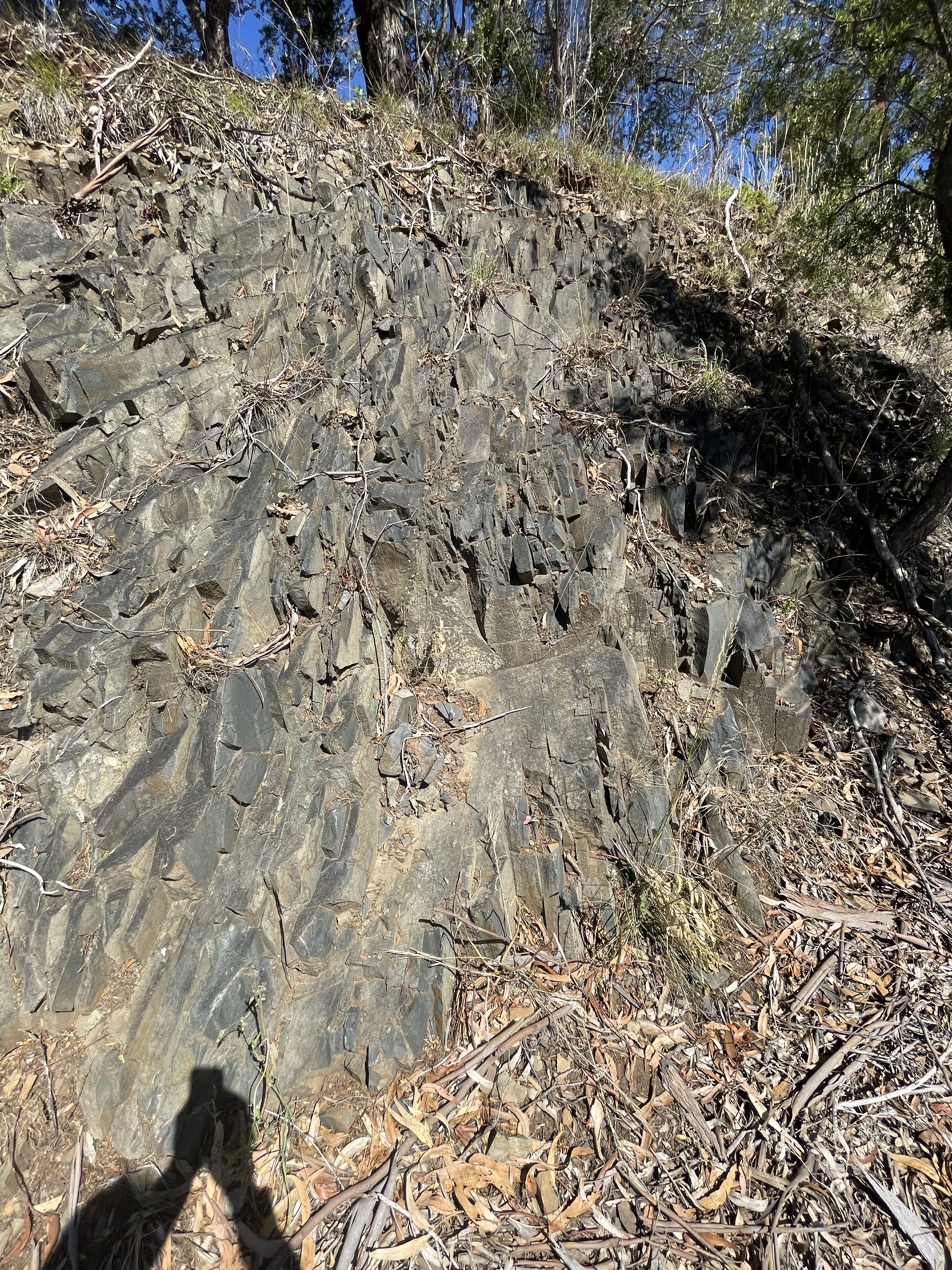 Fig. 4
I’m going to go out on a limb here (again) and say that the Jurassic dolerite in Fig. 4 is not contributing to the lovely, coarse-sand beach we saw in Fig. 1. Those sand grains came from the long-gone Triassic sandstones we saw in the last post. The Parmeener rocks, which are absent in this area, contain a lot of quartz and feldspar to form beaches.
For some reason, the Tasmanian Dolerite is pristine in this location and is photogenic (Fig. 5).
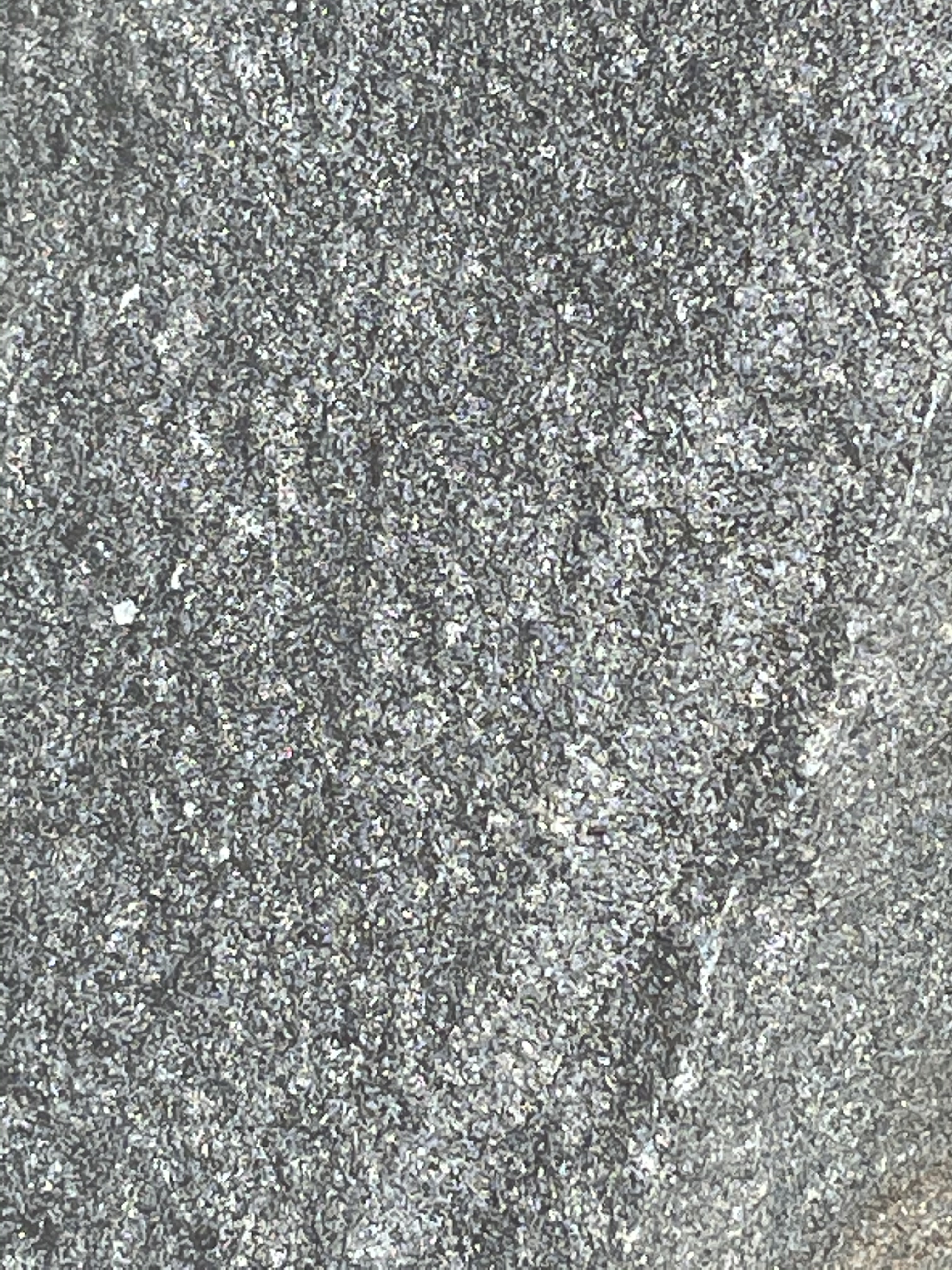 Fig. 5
Careful examination of Fig. 5 (field of view ~2 inches) reveals white and gray particles which we can assume are mineral crystals, albeit tiny ones. However, they are not shaped like the crystals we see in museums and most rocks. Some of them look more like organisms than minerals.
Studying Fig. 5 has made me struggle to remember my mafic intrusive mineralogy to no avail. I’m not an expert but I’ll share my explanation of the irregular crystals seen in Fig. 5. Mafic magma, from which dolerite crystallizes, typically contains pyroxenes such as augite, which has a high iron content and thus weathers into hematite, a red mineral. Magma is not uniform however, and this sample could have cooled and crystallized in a part of the original magma with a more alkaline composition (i.e. sodium, potassium, and possibly rare earth elements). Alkaline pyroxenes like Aegirine can crystallize with the right chemical composition of the magma and cooling history.
I couldn’t find anything general on the topic of weathering products of these minerals, but it makes sense to me that Na and Ca will weather into whitish minerals at low temperature and pressure. Feldspars with these elements certainly weather to produce white byproducts because of the sodium and calcium.
Bottom line: this dolerite is contributing nothing but quartz, and little of that (hard to tell from Fig. 5), to the beaches of SE Tasmania. The other minerals in a dolerite are either dissolved or bound to the clay minerals formed from original olivine, feldspar and pyroxene minerals. Clay minerals have a mineral structure that accepts almost any element.
About twenty miles north, we came to Kelvedon Beach near the town of Swansea.
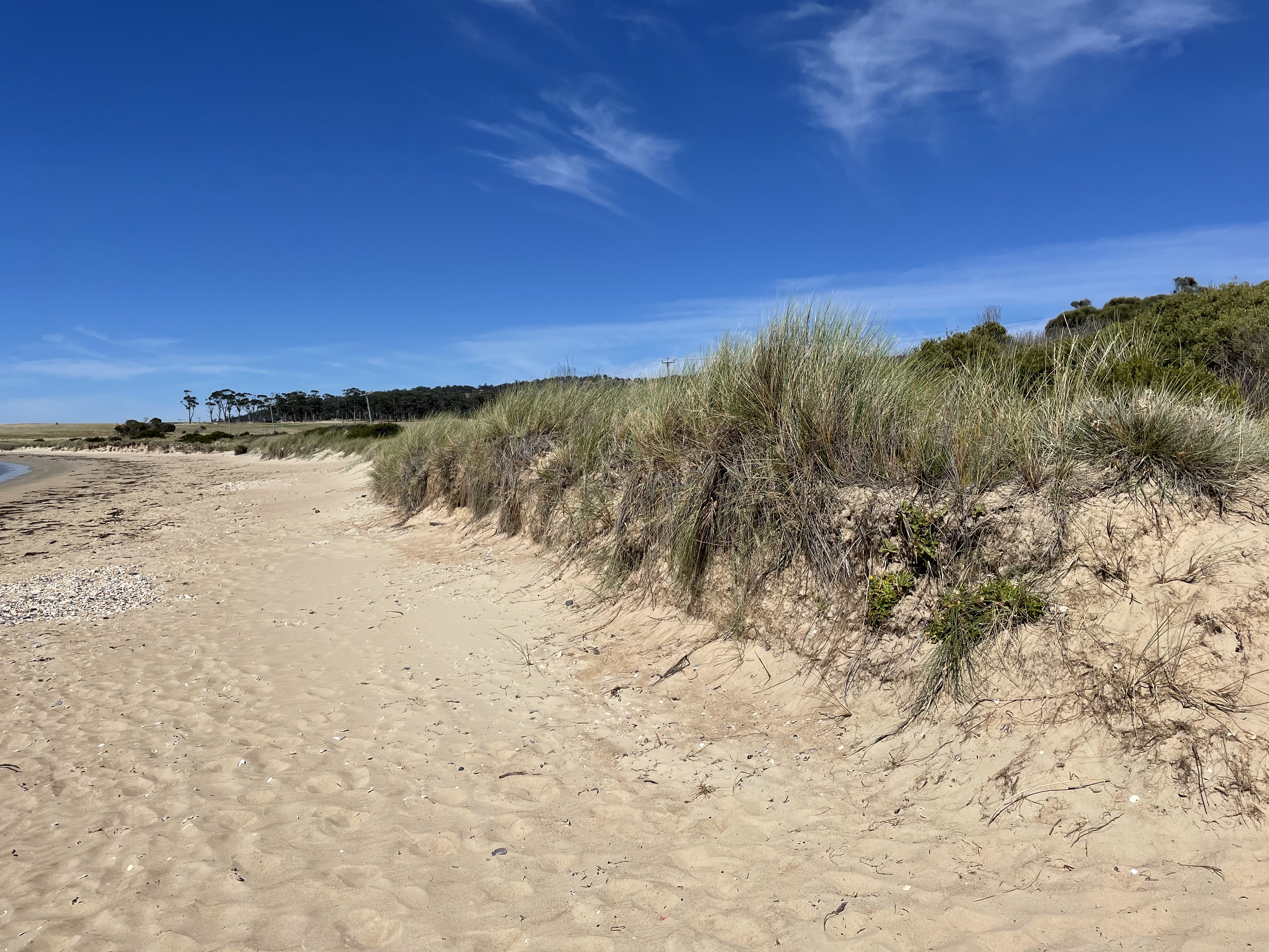 Fig. 6A
The foreshore, looking to the south (Fig. 6), shows an eroded dune and flat upper beach. Plants have regrown quite a bit, so it has probably been several years since the erosional event that removed half of the dune. That is a substantial volume of sand, possibly as much as 6 feet of dune.
 Fig. 6B
The high-water line (limit of slightly darker sand in Fig. 6B) is marked by an increase in shell material but there is no sign of berm growth, which suggests a lack of sand to replenish the shoreface. The assumption of a catastrophic event is supported by relict shell beds on the upper beach (Fig. 6C), located on slightly elevated areas where a berm should be. Further evidence of a huge storm is the low volume of sand being returned to the beach by wave action, a natural process that restores beaches after storm erosion. The lack of beach recovery, during an interval long enough for seagrass to be reestablished, implies that the offshore flow during the event was truly catastrophic, taking sand out of reach of fair-weather waves.
 Fig. 6C
Most of the shells seen in Fig. 6C were unbroken, as if deposited suddenly, rather than worked for months or years by waves, and broken into fragments. There were several patches of shells distributed irregularly along the shore, suggesting areas of concentrated wave power during the high-water event that eroded the dune. The lack of any burial or removal of the shells indicates that waves haven’t reached this high up the beach since the event. This beach is on a relatively open coast (pin in Fig. 6D). Waves interfere constructively to focus on sections of beach for various physical and meteorological reasons, and this is where erosion is greatest. The deposition of intact, disarticulated shells and excess sand in a low berm at hot spots, is what would be expected.
 Fig. 6D
The beaches of eastern Tasmania can teach us so much.
For one thing, timing is everything. With waves and currents about the same in the past, this region was receiving vast quantities of sediment in a rich variety of coastal environments. Today, there isn’t enough sediment to stave off the storms that impact the coast and thus the shoreline is eroding, slowly but surely. Bad timing. There’s absolutely nothing we can do about continental drift, but that isn’t the only factor affecting coastal erosion.
Erosion is also what happens to most coastlines during when sea level rises, such as has been happening steadily for the last 10,000 years. Rising sea level requires a massive input of sediment to fill all that newly acquired accommodation space. Very few coastlines meet the criteria.
We’re certainly not driving the train, but we aren’t helping the situation either, pumping greenhouse gases into an already warming atmosphere.
Nor can we get off at the next stop…

Trackbacks / Pingbacks