
Snoqualmie Falls: Eocene Volcanism in the Cascades Subduction Zone
INTRODUCTION.
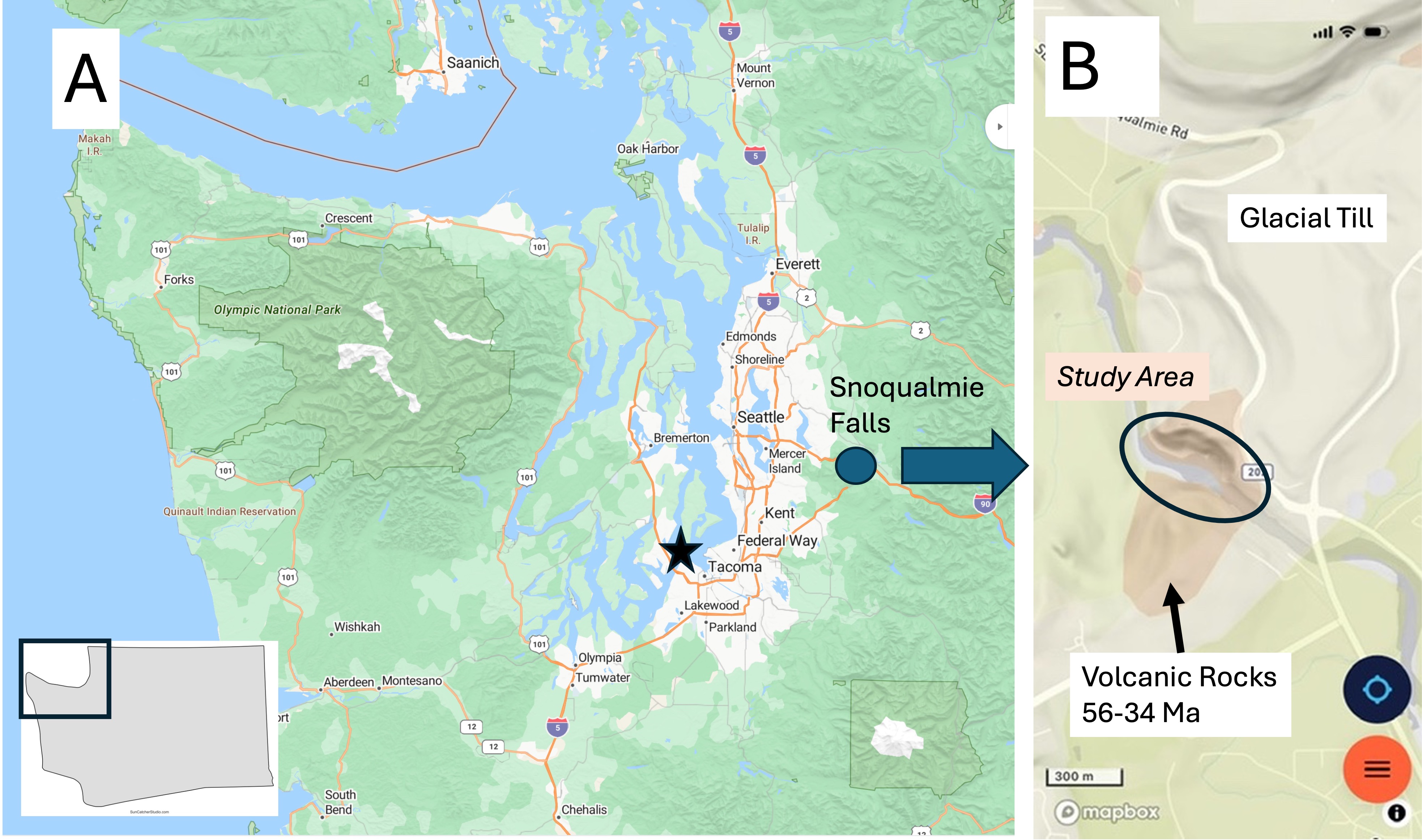
Figure 1. (A) Snoqualmie Falls is less than an hour from Tacoma, in the foothills of the Cascades Range of volcanic mountains. (B) The geologic map doesn’t show much besides glacial till, except around the falls (circled). I recently discovered that the Cascades is one of the youngest mountain ranges in the world, and it includes many active volcanoes that are part of the Pacific “Ring of Fire.” Most of the volcanic rocks were erupted from fissures and small volcanoes during the Eocene epoch (56-34 my ago). The active volcanoes (e.g., Mt St Helens and Mt Rainier) are less than a million years old, reflecting renewed magmatism at depth.
Observations
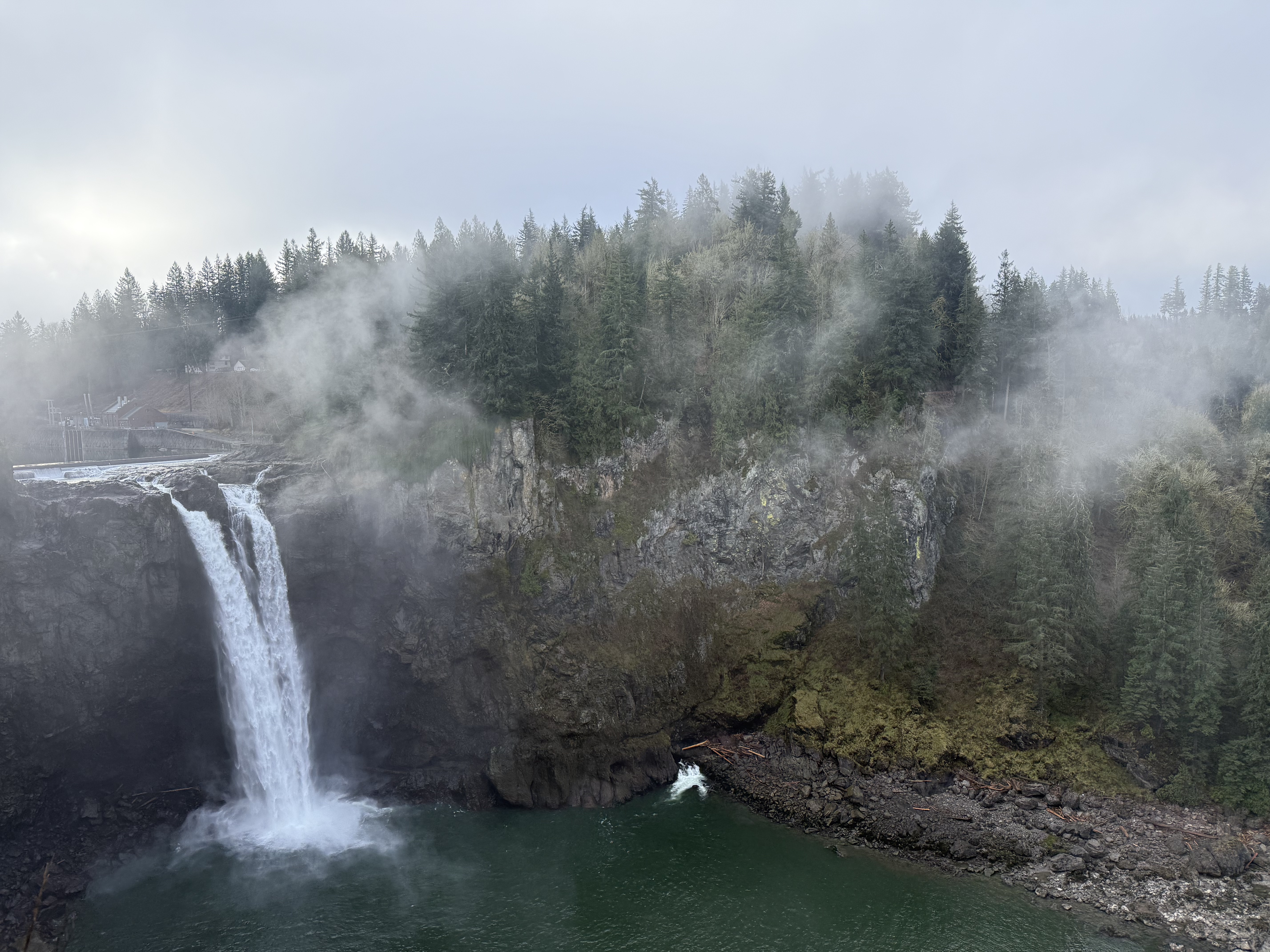
Figure 2. The 270 foot drop over Snoqualmie falls encouraged a private consortium to construct the world’s first subterranean hydroelectric power plant. The turbine outflow is visible at the bottom-center of this image. Note the massive wall of volcanics in the center of the photo. The exact origin of the falls is unknown because there are no major faults in the area, although the entire region is cross-cut by faults. The default narrative is a combination of glacial scour and natural variability in the rock composition and thus strength. For example, Niagara Falls was also formed during the last ice age along a natural escarpment, but the rocks comprise hard dolomite over soft shale; this combination led to undercutting and continuous upstream erosion at ~1 foot/year. All of the rocks at Snoqualmie falls are andesitic; however, note that the cliff ends to the right of the photo and a slope emerges. This could be a clue…
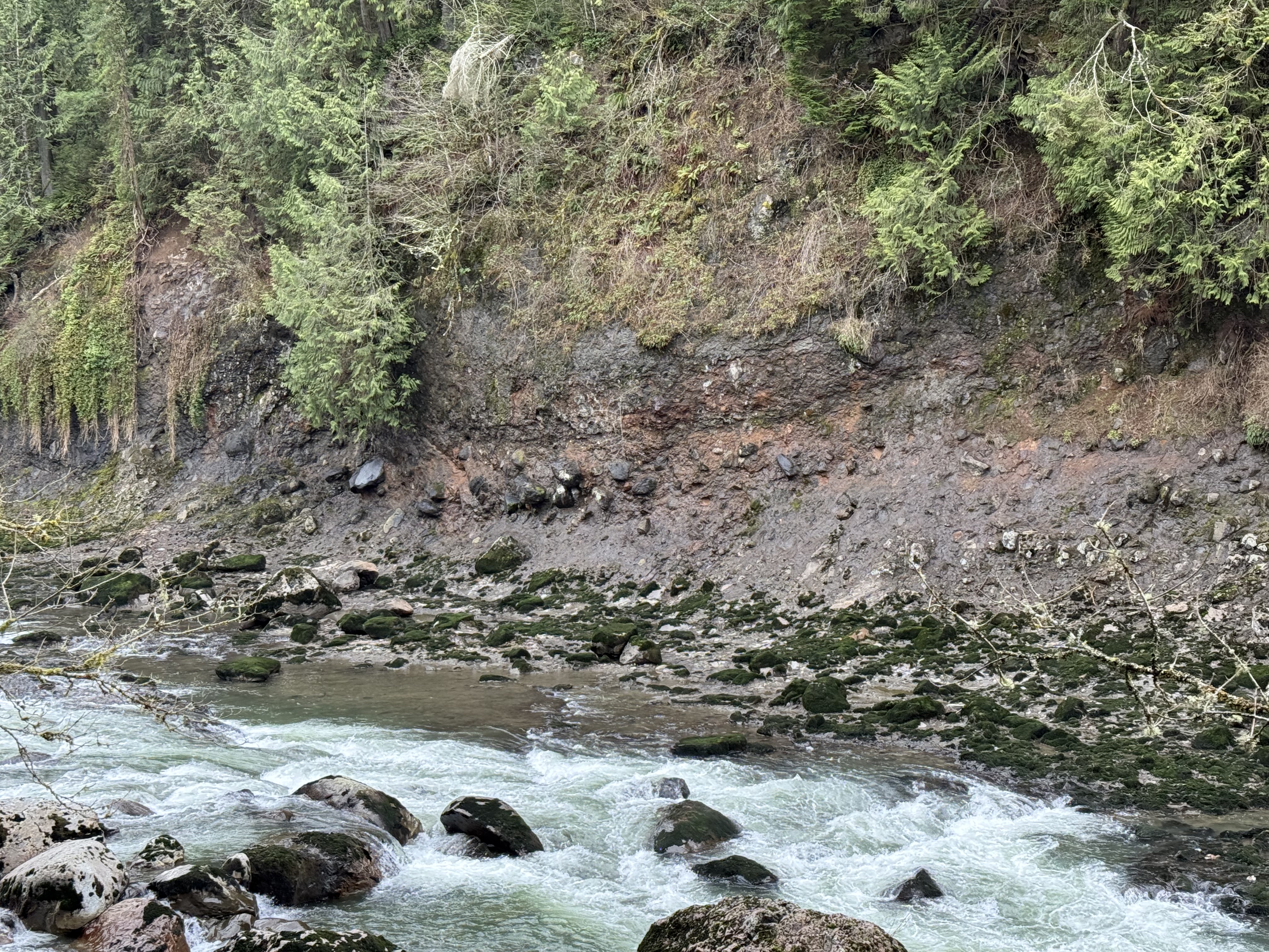
Figure 3. The riverbank several hundred yards downstream from the falls reveals a rock unit comprising large boulders in a matrix that erodes to form sand and mud.
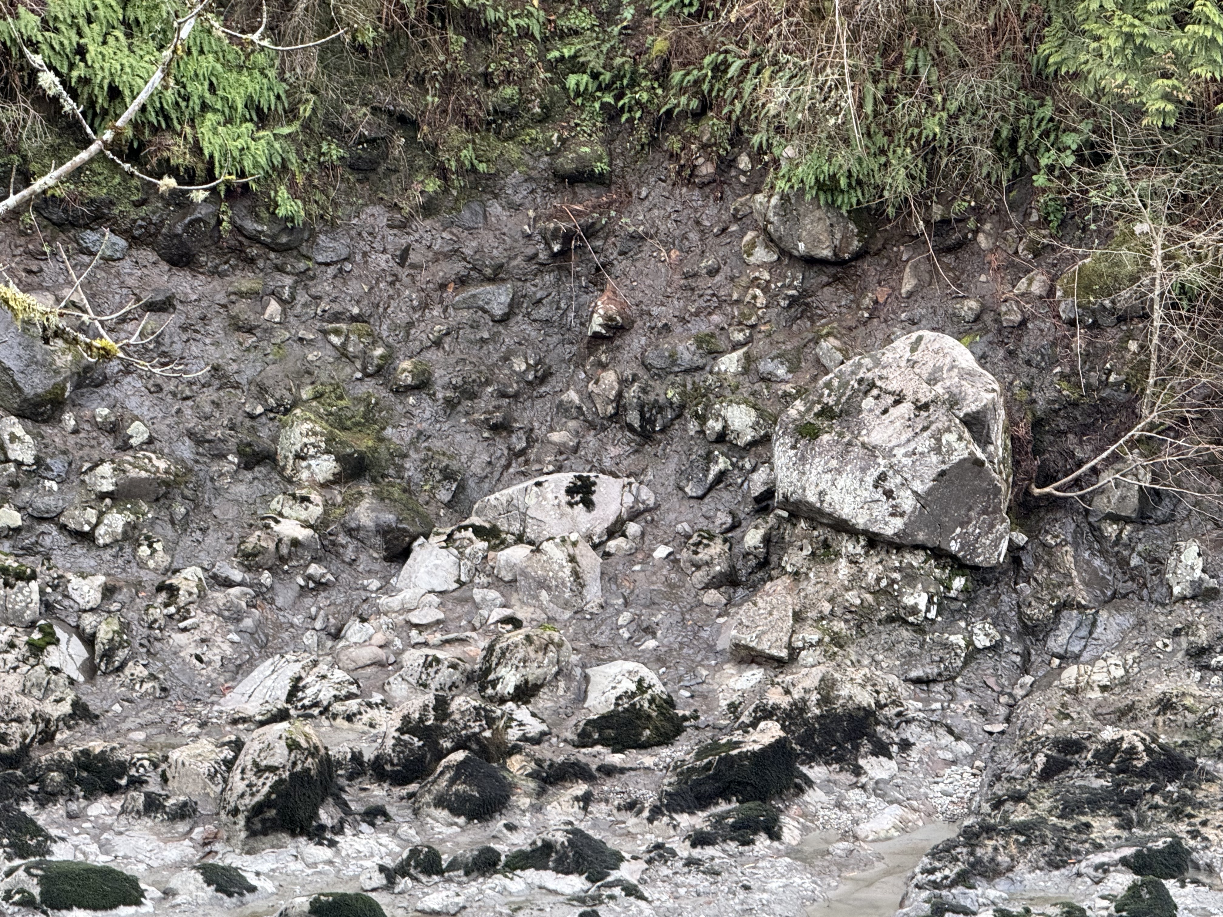
Figure 4. A close-up of the downstream bank reveals boulders several feet in diameter protruding from the cliff face. As the softer matrix material erodes, these blocks fall into the river. These are volcanic bombs–partially molten lava that solidifies in flight before landing far from the vent; volcanic bombs up to 20 feet in diameter have been ejected 2000 feet from the vent in volcanoes in Japan. Because they are soft, these ejecta become smooth during their flight and are sometimes flattened when they land. Consequently they can look like rounded boulders and cause confusion when found in a river. The giveaway is the matrix in which they are embedded. However, the story is more complicated than that…
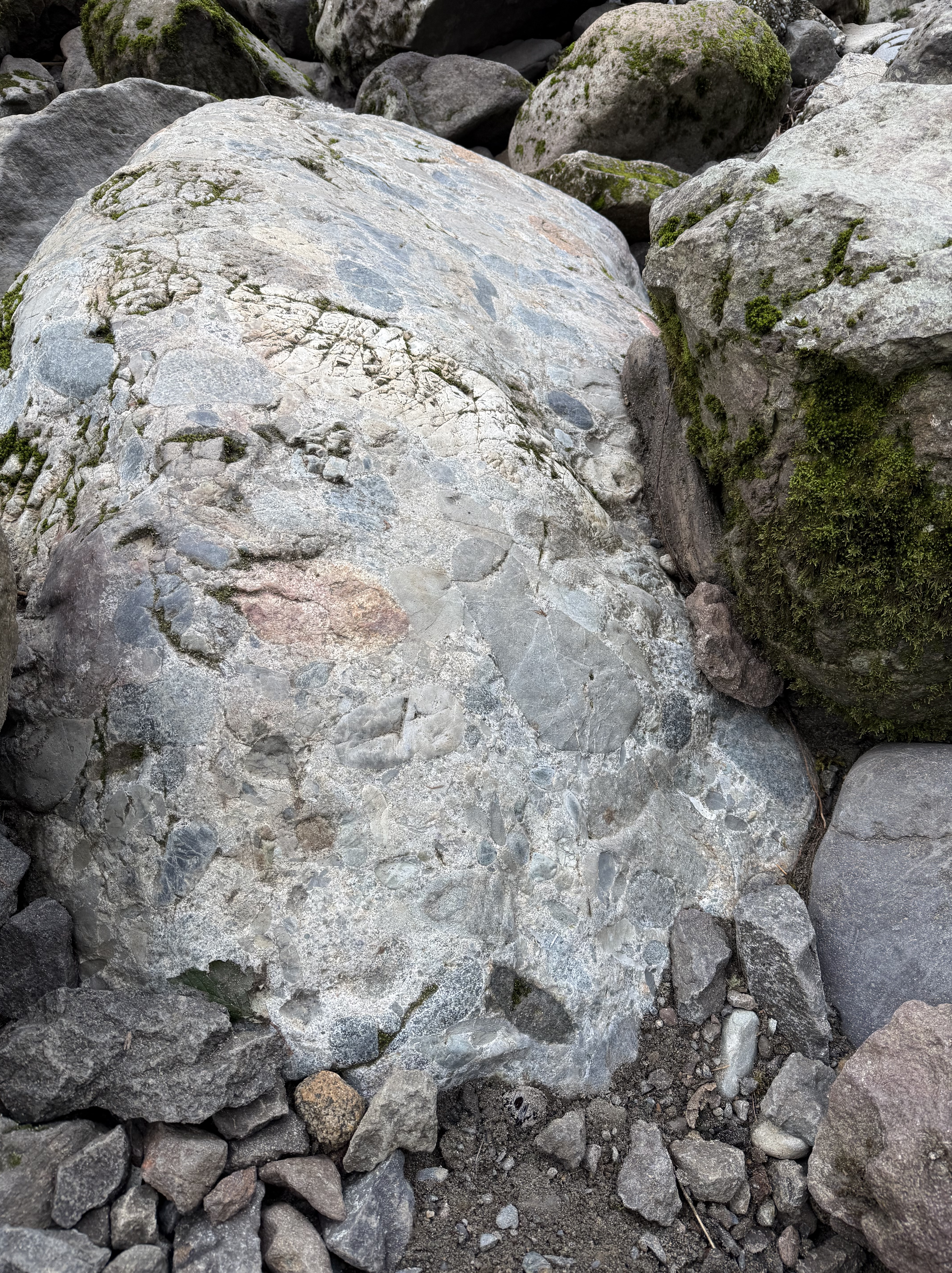
Figure 5. A boulder of volcaniclastic rock exposed in the river channel, rounded by collisions with other rocks. This sample is six-feet long. Note the mixture of tephra of different sizes and shapes. Each fragment was semi-molten when it was ejected from the vent; of course, it landed in ash rather than on hard ground. However…this sample comprises a matrix that is solid, not crumbly like the cliff base seen in Fig. 3; the only explanation I can think of is that the matrix varied substantially over time and space. In other words, this block represents an eruption of extremely hot ash, which formed a welded tuff (aka ignimbrite), encasing the tephra in stone immediately after eruption. The friable matrix in Fig. 4 wasn’t as hot; it is even possible (albeit unlikely) that this block was itself ejected from a younger eruption and became a volcanic bomb. I’m not putting any money on that; my point is that volcanic eruptions are very dynamic, and the rocks we see today represent millions of years of magma chamber depressurization.
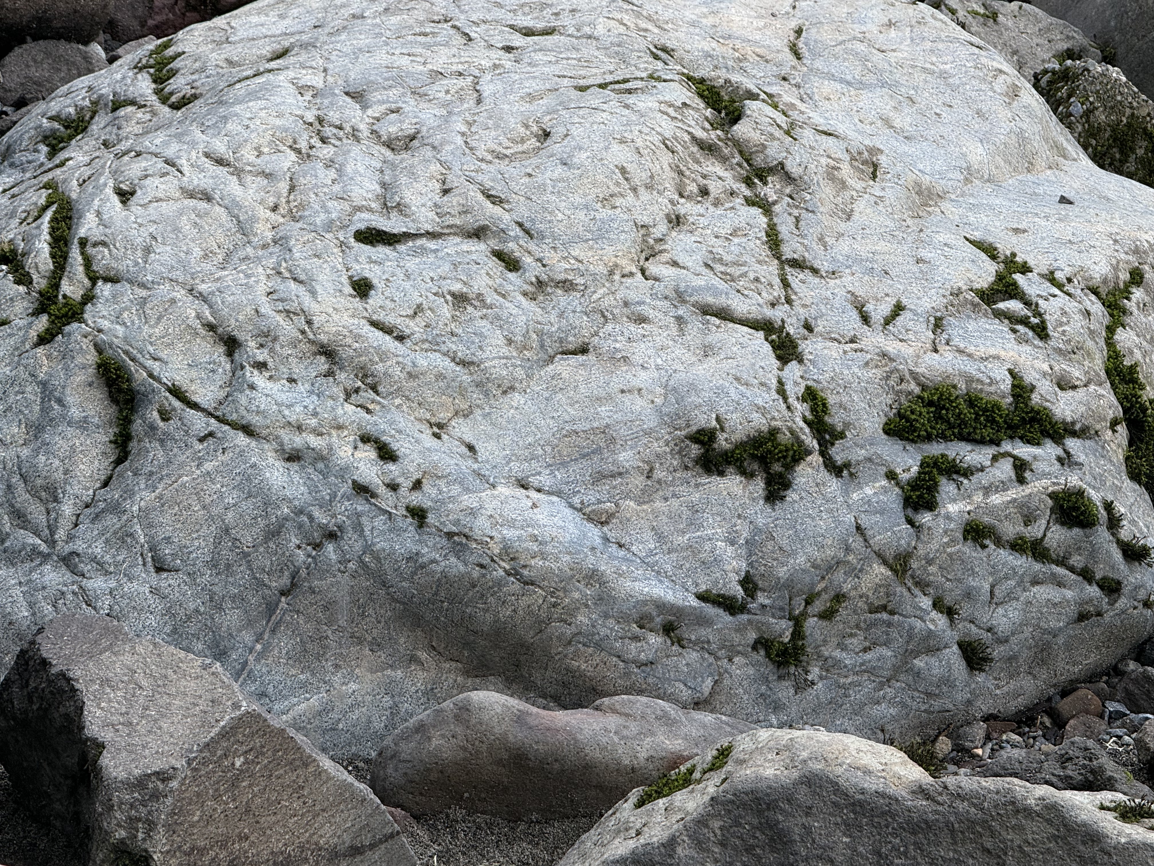
Figure 6. This eight-foot boulder contains fine layering in its lower half. This suggests that the tephra landed in a layer of ash that was so hot it became a welded tuff, even as eruptions continued intermittently. This block is NOT a volcanic bomb (despite my speculation in Fig. 5); it is a sample of the volcanic debris erupted from a vent (including volcanic bombs), which was subsequently eroded from somewhere within the local area, representing an eruption so hot it created an ignimbrite. This sample (as well as Fig. 5) thus reflects eruption and initial deposition, followed by erosion in a stream–giving them a rounded appearance similar to that of the tephra they contain; thus the term volcaniclastics.
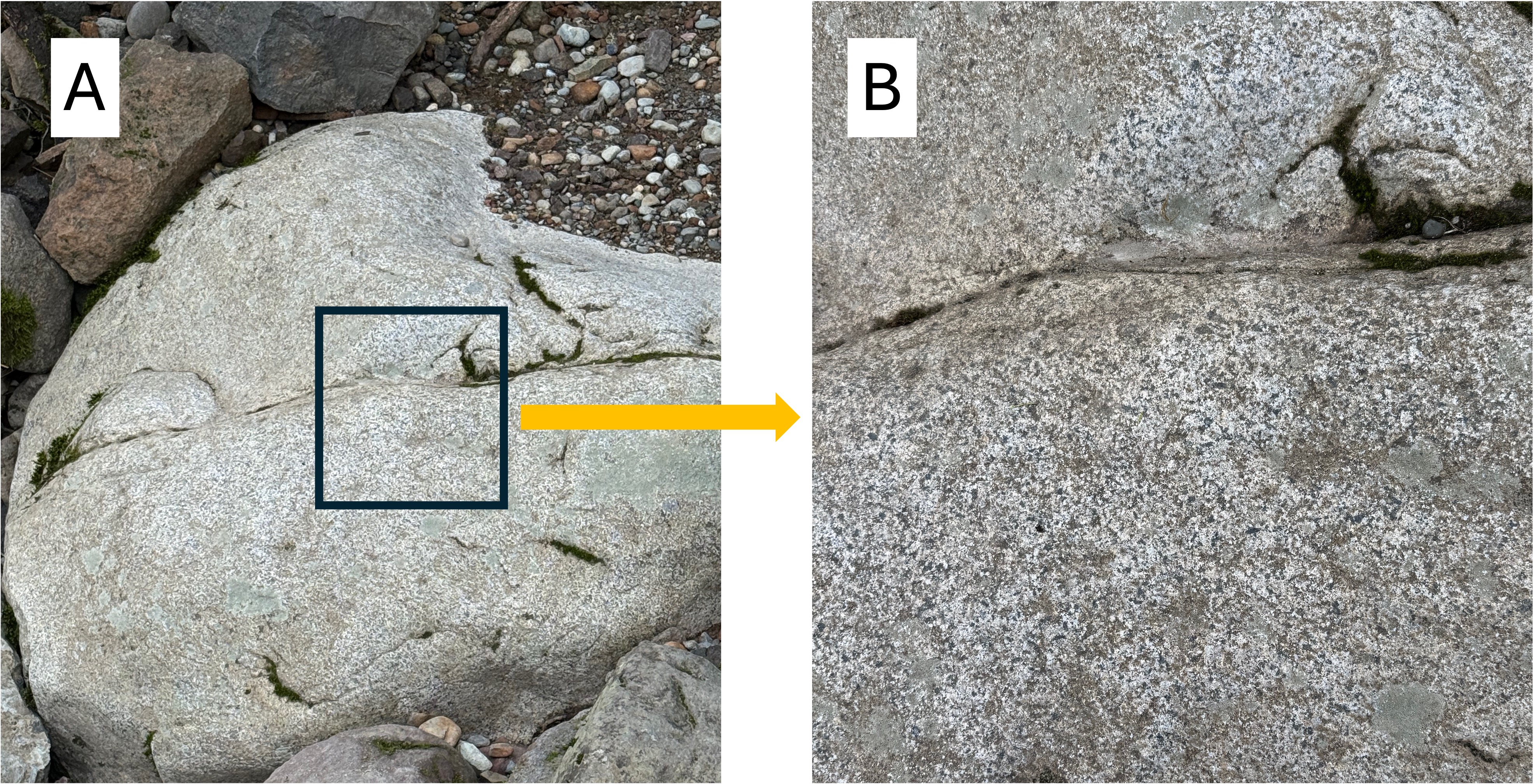
Figure 7. This is where this field trip got interesting. (A) This rounded boulder (4 feet across) doesn’t look like the volcanic rocks in Figs. 5 and 6. It contains no tephra or lamination. What’s going on? (B) A close-up photo reveals this to be an intrusive rock; individual mineral grains are visible, giving it a stippled appearance. It isn’t as coarse-grained as a classic granite with large crystals visible to the unaided eye; however, it isn’t extrusive either (microscopic grain size). This rock formed within a shallow magma chamber (possibly a dike or sill) in which the molten magma cooled faster than a deeply buried granite, but slower than an extrusive rock. This is common within volcanic terrains in which fresh magma is often injected into pre-existing layers of extrusive rocks. This sample is relatively fresh (i.e., no biological surface coverings) and thus its composition can be guesstimated: the whitish areas are feldspar (albite and plagioclase) that contains sodium and calcium, but not potassium; they comprise approximately half of the minerals; the darker grains are (probably) hornblende and biotite; a suggestion of gray implies some quartz. The relatively low quartz content suggests this is diorite. Diorite is the intrusive equivalent of andesite; it follows that the thickness of volcanic rocks visible in Fig. 2 is andesite, which is common in subduction zones. The bottom line is that this sample is NEITHER a volcanic bomb nor a block of the tephritic, extrusive rock seen in Figs. 3 and 4. It was probably emplaced within layers of older volcanics and later eroded, eventually falling into the river, where it was rounded by collisions with other boulders.
SUMMARY.
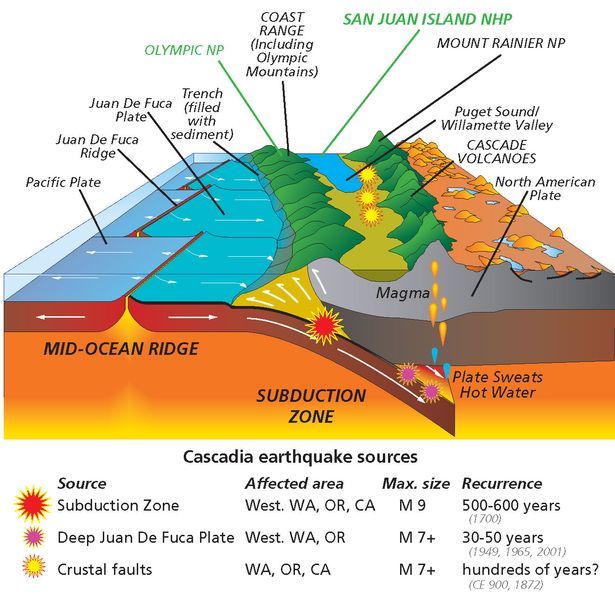
Figure 8. Snoqualmie falls is located at the northern end (top) of this schematic, within the second belt of mountains (green). The history of subduction along the Pacific Northwest (PNW) is uncertain because of intermittent subduction and crustal thickening. When Pangea split along what is now the mid-Atlantic ridge system about 200 my ago, the North American plate began a complex history of either riding over the Juan de Fuca oceanic plate or colliding with various islands and micro-continents that were in the way. By these disparate accretionary mechanisms, the west coast of N. America propagated westward hundreds of miles, at least from Montana. Jumping ahead to 50 my ago, a new round of subduction began, characterized by multiple vents, fractures, and volcanoes; these produced the older rocks of the Cascades. The Columbia plateau basalts were erupted about 15 my ago–Act II in this ongoing geological opera; the third act (using a simple theatrical model) was the appearance of multiple volcanoes fed by localized magmatic chambers in the last million years. This geological opera is complicated by at least two distinct events: (1) the San Andreas transform fault and associated strike-slip faults from Mexico to Canada, which together transport crustal blocks to the NW (i.e. Alaska); and (2) the anomalous mantle plume associated with the Yellowstone caldera.
Unlike the ancestral Appalachian mountains, whose geological history must be inferred from fragmentary and ambiguous data, the PNW geo-opera is being performed before our eyes.
Think about it–Mt St Helens wasn’t an outlier…anything can happen in the PNW…
Quaternary Geology on Mt. Rainier

Figure 1. View of Mt Rainier from the west. At 14410 feet, it is the most prominent peak in the contiguous United States. It has 28 glaciers, with the largest total surface area in the lower states–35 square miles. Mt Rainier is a stratovolcano, composed of andesitic lava (rather than basalt), material ejected from the summit, and ash layers. This type of volcano is commonly found in subduction zones; they tend to have explosive eruptions (e.g. Mt Saint Helens). The oldest rocks on Mt Rainier are about 500,000 years old. It is active and listed as a decadal volcano–one of the most dangerous volcanoes in the world. Its last major eruption, accompanied by caldera collapse, was 5000 years ago, but minor activity was noted during the nineteenth century.
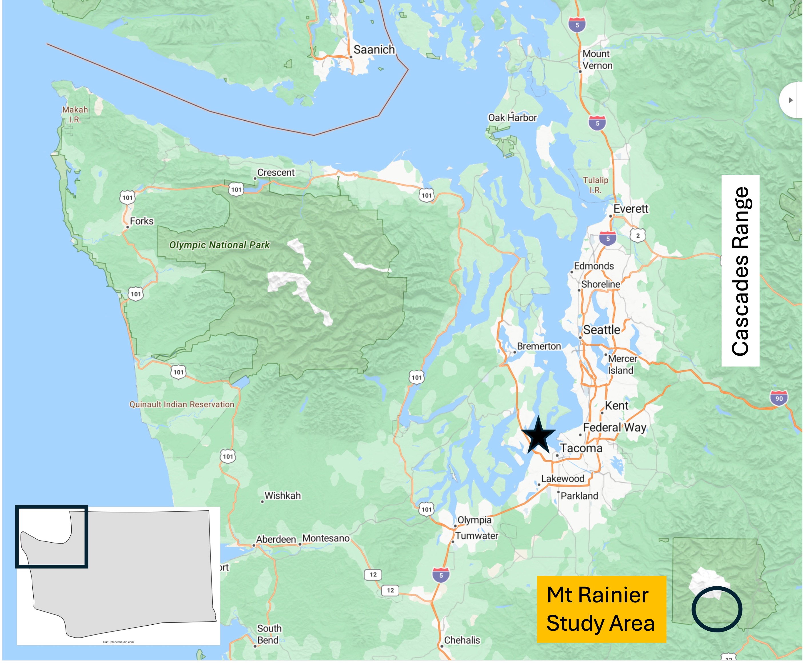
Figure 2. From my home in Tacoma (star) it’s a two-hour drive to Mt Rainier National Park. It is part of the Cascades Range, which comprises many well-known volcanoes like Mt Baker, Mt St. Helens, and Mt Hood.

Figure 3. This photo was taken on the south flank at an elevation of about 5400 feet, near the visitor’s center. It was a beautiful day and there were a lot of people preparing for some cross-country skiing on a couple of feet of snow. From this elevation it takes 2-3 days to reach the summit, almost 9000 feet higher. It’s hard to imagine it being so high and taking so long to reach.

Figure 4. These southern volcanic mountains are part of the Tatoosh Range, with peaks of about 6600 feet. Most of the volcanic rocks comprising these mountains are andesite, intermediate in composition between basalt and rhyolite. It is also very viscous, behaving like peanut butter and thus not flowing well. Andesite is commonly found at convergent plate boundaries where it is thought to result from mixing of basalt (from the oceanic crust), continental crust, and sediments accumulated in the accretionary prism.

Figure 5. Map of the 28 glaciers on Mt. Rainier. The glaciers fill canyons and valleys that were partly cut by ice. Figure 3 shows a smooth mountain, but in reality most of the smooth areas are the surfaces of glaciers. We’ll look at one below. The ellipse indicates the area discussed in this post.

Figure 6. (A) Narada Falls interrupts the descent of Paradise River, fed by Paradise Glacier (see Fig. 5 for location), making it drop a couple hundred feet over a thick layer of andesite. Andesite tends to form blocky flows, as shown in the right side of the photo, where the water seems to be climbing down steps. (B) Possible contact between younger volcanic and older intrusive rocks. Igneous activity within the area has been continuous for at least 50 my, during which time erosion has exposed older intrusive rocks like this granodiorite, which is part of a pluton intruded between 23 and 5 Ma. It is important to keep in mind that the volcanic rocks originated in plutons (magma chambers) emplaced miles beneath the surface. As they are exposed, new volcanoes form as more magma is injected into the shallow crust in a continuous process. (C) Differential weathering has accentuated layering in this volcanic rock, which was probably created by a series of ash layers deposited in quick succession–geologically speaking.
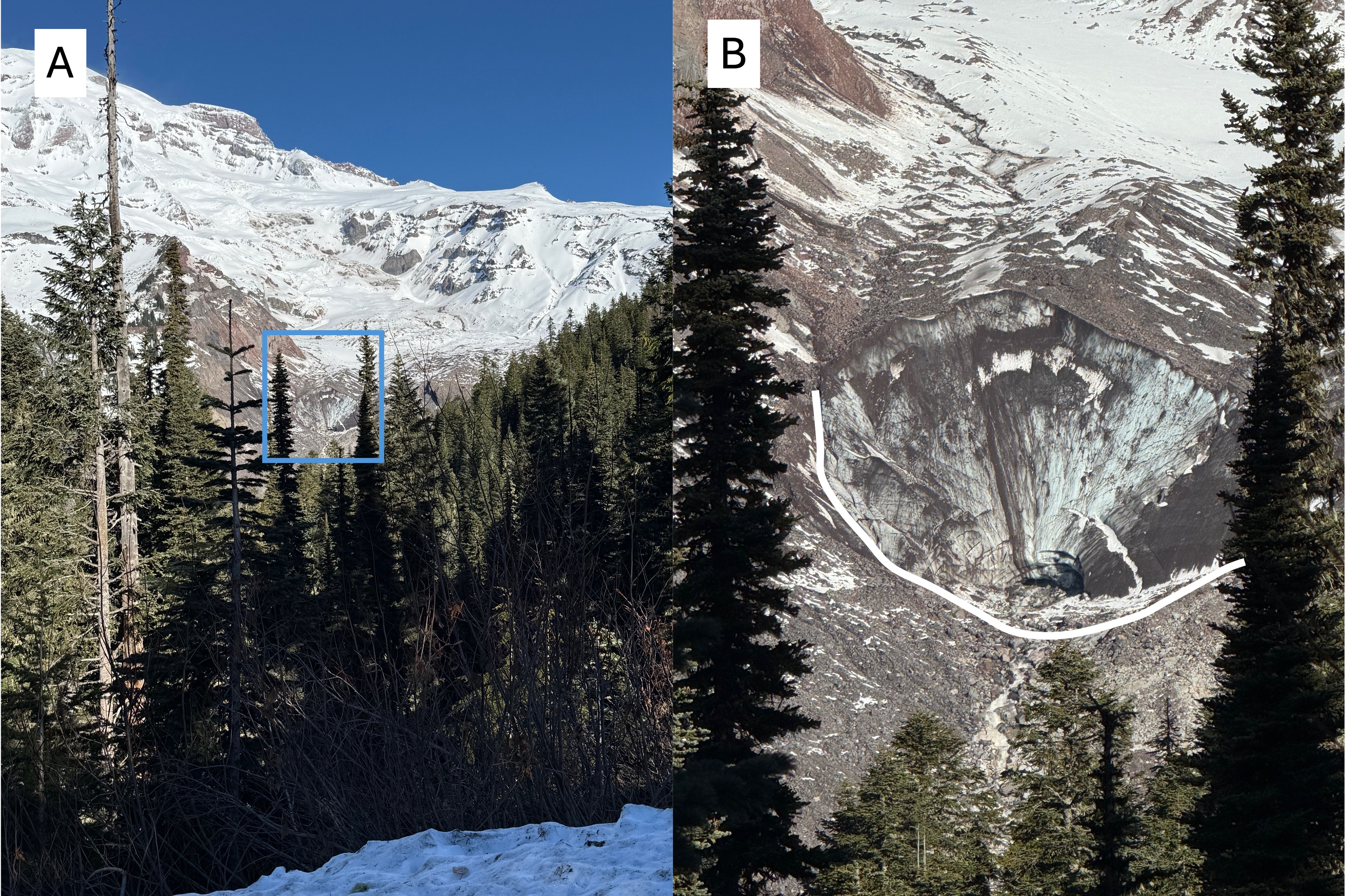
Figure 7. (A) View looking north towards the source of Nisqually Glacier (see Fig. 5 for location), which originates near the peak of Mt Rainier. The area delineated by the blue rectangle is the face of the glacier. (B) Closeup of the face of Nisqually Glacier. The characteristic U-shaped valley carved by glaciers is highlighted in white. Note the dark material within the glacier, probably wind-blown fine sediment. It looks like the face is a couple hundred feet high. I’ve never seen a retreating glacier before, so this is pretty spectacular to me. The Nisqually River originates right here…
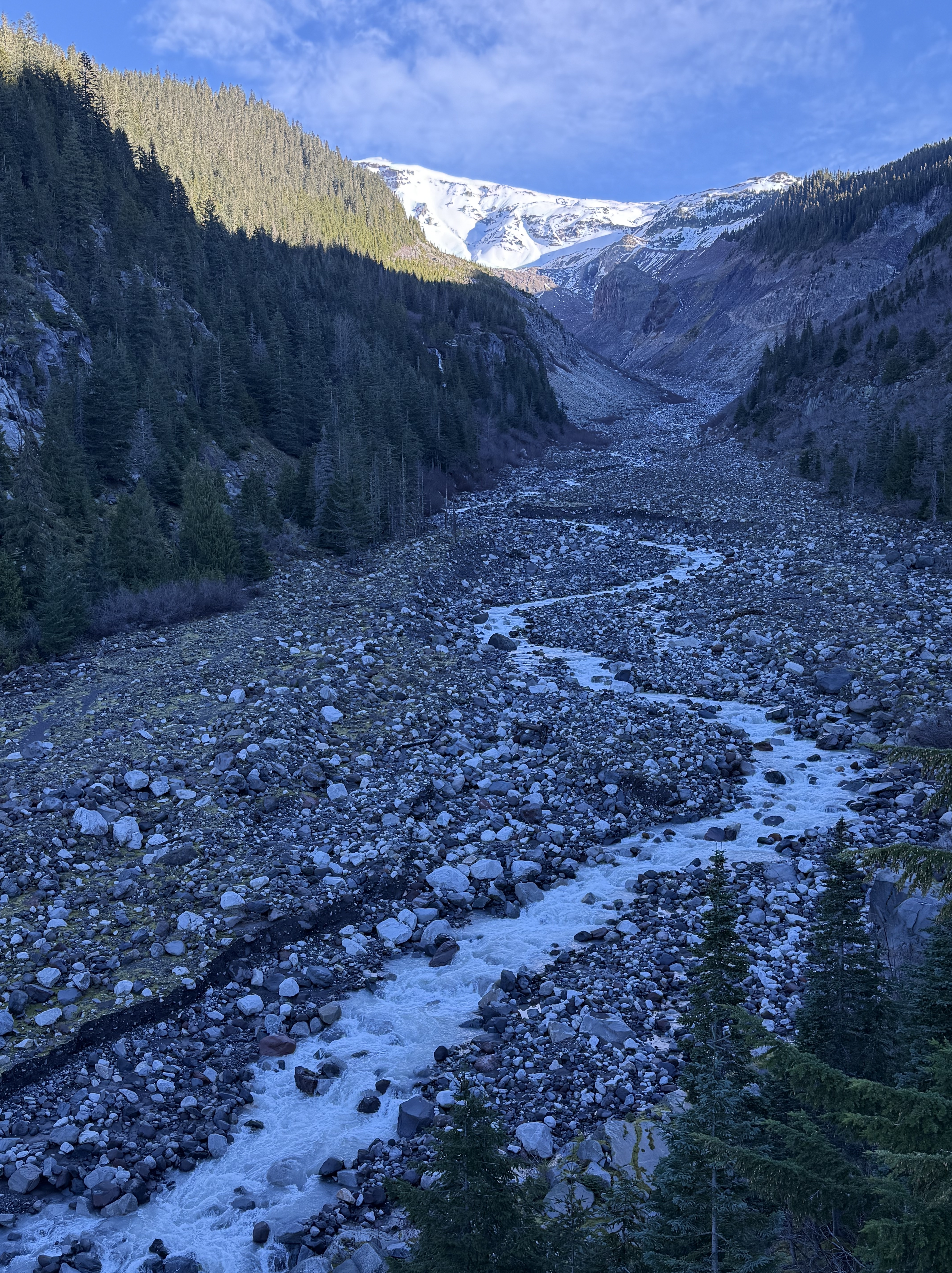
Figure 8. View looking upstream along Nisqually River a mile downstream from Fig. 7. This is one of the most stunning photos I’ve ever taken because it reveals geological continuity, from the origin of a glacier 10000 feet higher, to the outwash being transported by a river. Amazing! Note the perfect U-shape where the shadow ends upriver. This area would have been covered by the glacier as recently as 10000 years ago.

Figure 9. Another mile downstream from Fig. 8 the walls of the valley have lowered, and are now rimmed by volcanic flows half-buried by detritus. Evidence of a glacier filling the valley has been erased by collapse of the valley walls. Rounded boulders fill the riverbed. The Nisqually River is overwhelmed by the huge sediment load and opens up new channels to continue flowing.

Figure 10. View looking upstream at the confluence of Nisqually River and Van Trump Creek. There are a couple of interesting features visible in this braided stream bed, less than two miles from the glaciers feeding each branch. The valley is very wide and flat-bottomed because it was carved by glaciers more than 10000 years ago. The large boulders (as large as three feet) covering the entire valley floor were transported by a glacier and became relict after its retreat because the stream flow, even during floods, is too weak to transport and erode them. The Nisqually River is cutting a channel through these relict sediments; the scarp is about eight feet in height. The white line delineates large, surface boulders from subjacent sand and silt with few boulders. Note that the surface boulders stop upstream where the white line curves sharply upward.

Figure 11. Image from 200 feet downstream of Fig. 10, showing a break eroded in the boulder-bar that crosses the stream bed at an angle. During recent heavy rain Nisqually River broke out of its current channel and created a myriad of flow structures such as the longitudinal bars seen in the lower-right of the photo. I think this bedform is actually a terminal moraine marking the maximum advance of a previous glacier–not necessarily the maximum glacial extent during the last two-million years.

Figure 12. (A) Andesite boulder (2 feet across) wet by recent rain shows fine-scale structure. The irregularity of the laminae, and phenocryst distribution, suggest to me that this sample represents ash fall rather than a flow. Magma with the viscosity of peanut butter tends to form smooth lines because it is difficult to penetrate, which would be necessary to create the mixed-up appearance between the lighter and darker shades in the center of the image. (B) Large block (~10 feet long) of intrusive rock similar to that seen at Narada Falls (Fig. 6B), but this is two-miles downstream. This relic was pushed/dragged by a glacier to this location. The white circle indicates where a close-up photo was taken. (C) Close-up (5x) image of the heavy block. It contains quartz (Q), plagioclase/albite feldspar (no orthoclase) (F), and amphibole (Am). My estimate of the composition is: 50% feldspar; 30% quartz; and 20% amphibole. Based on my estimated mineral composition, this would be granodiorite; however, I didn’t differentiate plagioclase and albite feldspar. (The former is darker than the latter.)
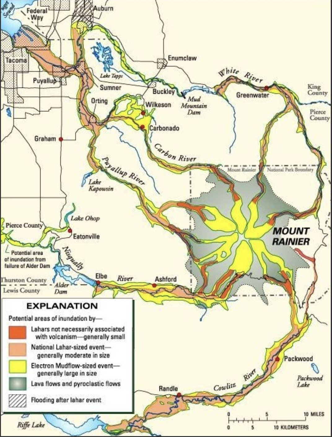
Figure 13. Map of potential volcanic risks associated with Mt Rainier–besides an explosion (e.g. Mt St Helens) and the eruption of ash which would cover a large area, depending on wind direction. Lahars (mud flows fed by all those glaciers) pose the greatest risk because andesite is too viscous to flow more than a few miles from its source.
Summary. I have seen evidence of continental glaciers in the Great Plains, the German Plain, and Ireland, but I never had the opportunity to observe glaciers up close. Alpine glaciers were nothing more than an abstract idea to me, something viewed from a distance.
I’ve looked out over the clouds from the summit of Haleakala crater on Maui, gazed into the cauldron of Kilauea, witnessed the boiling water rising from beneath Yellowstone’s seething caldera. I’ve seen videos of volcanic eruptions in Iceland, but I never imagined putting the glaciers and volcanoes together–right next door!
Usually, geology is observed as a series of images frozen in time, but at Mt Rainier it can be glimpsed as a real-time process that reshapes the earth’s surface–from top to bottom.
What a wild geological ride!
Deception Pass: Ophiolite or Volcaniclastic Sediments?
Now that I have a general idea of the geologic history of Northwest Washington (NWA) it’s time to start filling in the blanks. I immediately found a discrepancy in the rocks found on the northern end of Whidbey Island and the adjacent peninsula (Fig. 1): some authors identified these rocks as ophiolite–pieces of ocean crust that contain evidence of extrusion at mid-ocean ridges. Let’s see what I found.
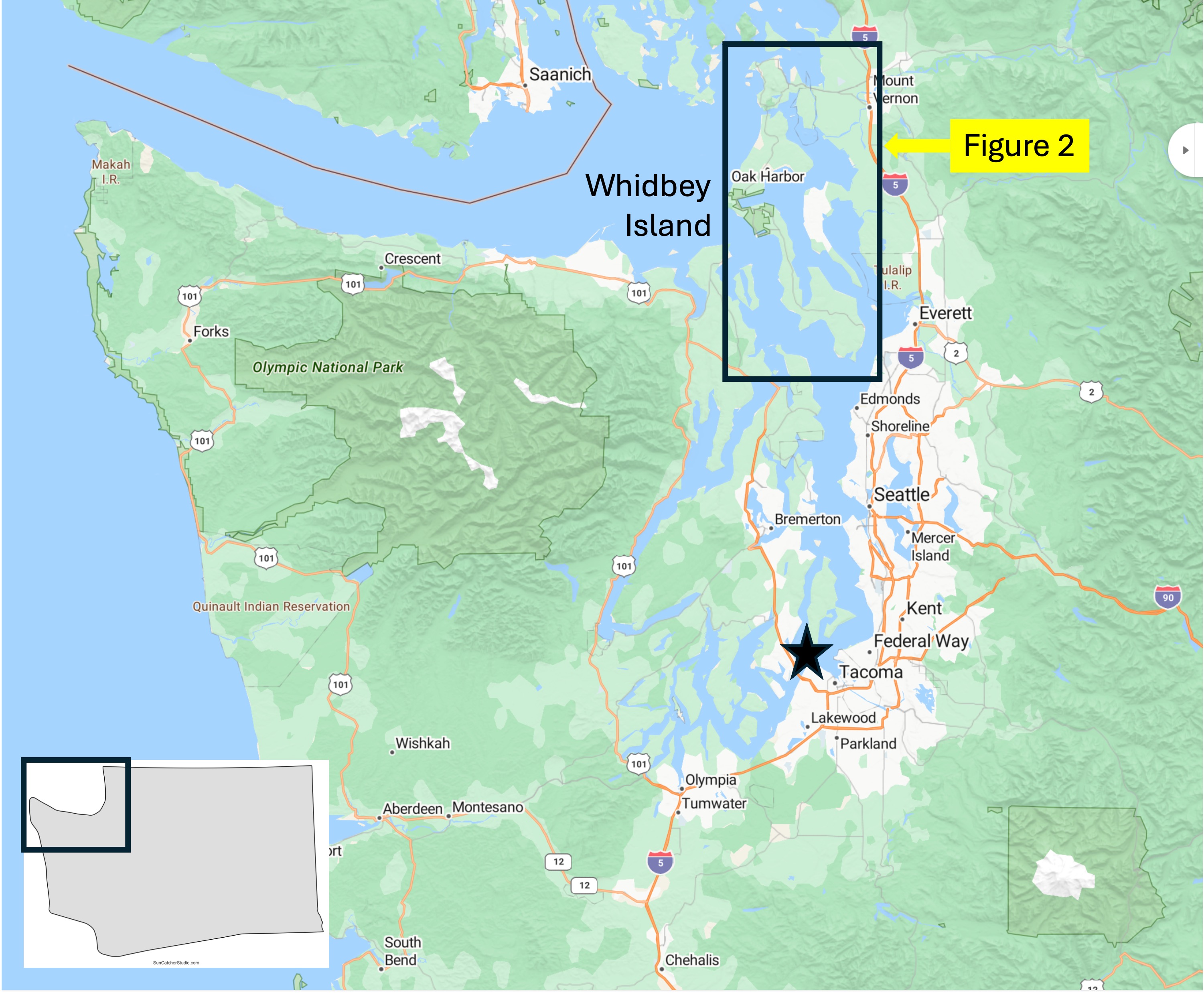
Figure 1. Whidbey Island is a large island that is almost completely covered by glacial sediments. Its elevation varies from less than 100 feet above msl (mean sea level) to almost 400 feet, probably reflecting the presence of terminal morraines deposited as glaciers retreated. The box encompasses the study area, and the star is my home in Tacoma.

Figure 2. Progressively more detailed maps of Whidbey Island, showing the geological formations discussed in this post. (A) Deception Pass is a narrow channel (~200 yards wide) between Whidbey Island and a tiny island that connects it to a peninsula. Glaciers covered this entire area, advancing and retreating for at least two million years, while scraping out Puget Sound from unconsolidated sediments and easily eroded rocks. I entered Whidbey Island via a ferry from the mainland just north of Seattle. (B) Geologic map of the norther tip of Whidbey Island and the adjacent peninsula. The tan areas are covered by glacial sediments whereas the blue and green areas are reported as volcaniclastic rocks by Rock-D and the US Geological Survey national map. However, I read a Washington State geological report from 1962 that reported layered gabbro and other indices of a classic ophiolite sequence. Were Washington’s geologists incompetent? Over eager? Non-peer-reviewed? Or maybe they stumbled onto an exposure, described it in a state report, and, when no one cared, dropped it until they retired. I don’t know. Nevertheless, everyone is in agreement that the age of these rocks, which include basalt and marine sediments, is poorly constrained: they could be as old as 251 Ma, the beginning of the Mesozoic era; and as young as 66 Ma–the end of the Mesozoic. Wow! The thin, black lines indicate faults inferred from stratigraphic relations. The USGS has adopted the generally accepted paradigm of gathering legacy geological formations into larger groups that reflect the plate tectonic setting, rather than geographic location. The “official” description is so encompassing (including the kitchen sink) that it could easily include what the Washington geologic report called “ophiolite”. (C) Detailed map showing my approximate location along the path that followed the shoreline (blue circle) and the location where I saw these rocks in an excellent exposure (yellow diamond). I’m not sure why the rocks south of Deception Pass (blue) are differentiated from those on the north side (green) by Rock-D; the USGS map shows they are the same, as does my field examination (discussed below).
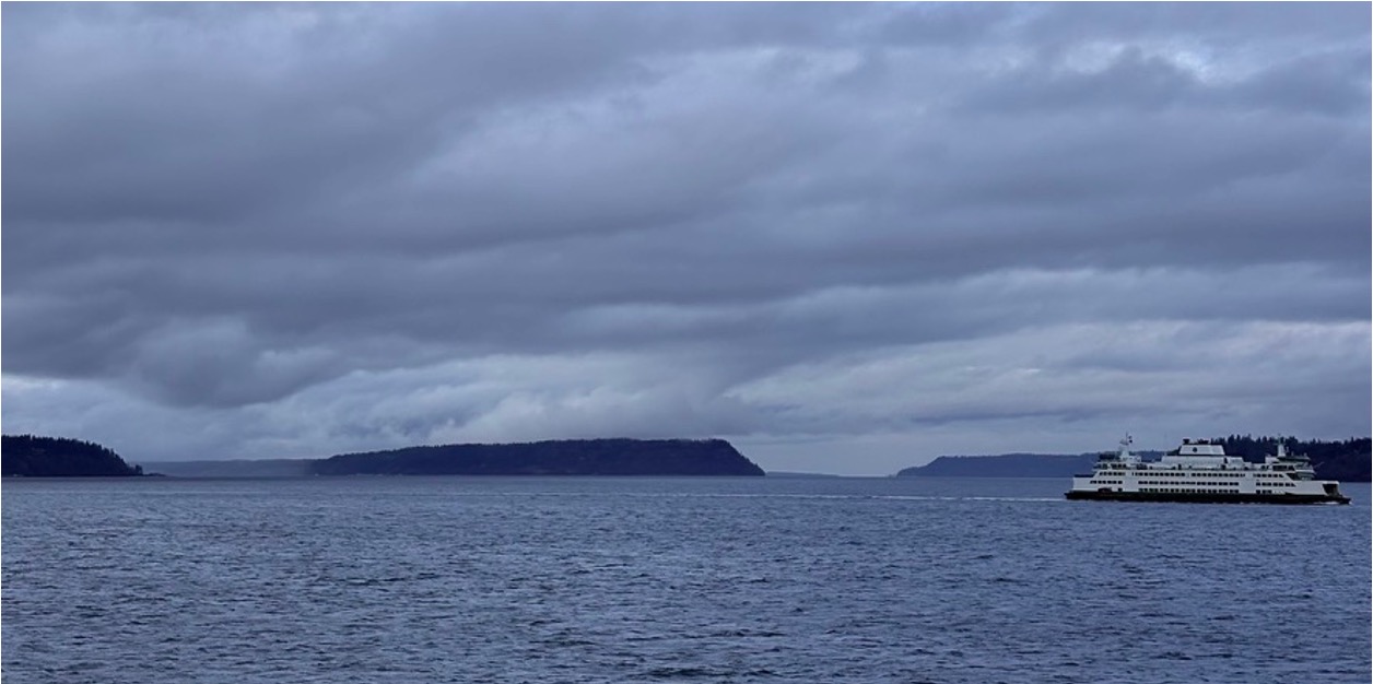
Figure 3. The ferry ride from Mulkiteo to Whidbey Island (see Fig. 2A) shows the same high elevation of Whidbey Island (left), Hat Island (center), and a promontory north of Tulalip (behind the ferry; see Fig. 1). This elevation of glacial sediments is approximately the same as the basement rock discussed below. This high relief shoreline is found throughout Puget Sound.
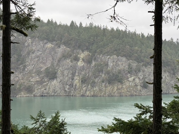
Figure 4. View looking north across Deception Pass, showing the nearly vertical bedding of rock layers, which could be original sedimentary fabric, metamorphic surfaces, or joints. Let’s have a closer look.

Figure 5. Images of the exposed rocks near the top of the hill overlooking Deception Pass (see Fig. 2C for location). (A) These medium bedded (~6 inches) layers contain clasts of different rocks. The height of the image is about six feet. (B) This twelve-foot exposure shows thin-bedded sand/silt layers with intercalated mud, but the layers are overturned (more than 90 degrees from horizontal) and reveal rapid changes in bedding, in addition to large boulders of material. (C) A bedding surface shows the characteristic sheen of schist, which adds metamorphic foliation to original bedding. These rocks are not heavily altered, so the layers seen in (B) probably reflect original beds. The clasts in (A) are matrix supported, which suggests mixing of different sized particles. This unusual texture occurs in environments where periodic mass failures (e.g. landslides or submarine slides) occur.

Figure 6. These images from about 100 feet elevation show more details of the rocks exposed at Deception Pass: (A) These layered sediments vary from medium to thick bedded and they also reveal gentle folding at this scale (the photo is ten feet high), suggesting that the overturned beds may be part of a large fold, possibly related to the faults seen in Figs. 2 B and C; note that the faults have a NW-SE orientation approximately aligned with the fold axis (I didn’t make careful measurements). It is also possible that the faults reflect brittle failure as the rocks were uplifted within the accretionary prism. (B) The left half of the exposure reveals a thick (> four feet) layer containing mixed clasts in an otherwise fine-grained matrix. The right side contains medium beds of a lighter material (We don’t want to get carried away here because of the vagaries of chemical weathering.) However, the contact between the two apparent lithologies is irregular; If I’m right about the left side being the bottom (questionable), this could have been a volcaniclastic slide (basalt, ash, pieces of rock, etc) that was then filled in by less catastrophic sedimentation. I admit I’m speculating, but we have to imagine life on the continental margin during active volcanism, during subduction.
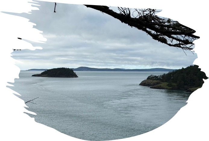
Figure 7. This photo was taken looking west from Deception Pass (see Fig. 1), towards the Pacific Ocean. Those islands are emergent blocks of jumbled Mesozoic/Tertiary sedimentary and volcanic rocks. The last ten-thousand years of sea level rise has covered most of the evidence contained within the accretionary prism, leaving us with only fragments.
Conclusion. I didn’t see any ophiolite at Deception Pass, but there is plenty of evidence of accretionary tectonics; deeply buried sediments and volcanics were scraped off the subducting oceanic crust and deformed continuously. This process has to obey the laws of conservation of mass, which means that the accretionary prism accumulates further west with each passing year. What we see exposed at the northern end of Whidbey Island is occurring today beneath the continental shelf, all while the Juan de Fuca plate is swallowed by the earth’s mantle. There is a two-mile-deep trench about 100 miles off NWA, but it is filled with sediment eroded from N. America, unlike more-familiar deep-sea trenches (e.g. the Mariana Trench, about 7 miles deep).
All that sediment in the subduction trench is like sand in in your transmission: it gums up the works and slows things down, but the Earth cannot be stopped, its relentless, insatiable appetite for oceanic crust never satisfied. It will keep chewing up the Juan de Fuca plate until the upper mantle decides that enough is enough and stops pushing N America westward.
I can’t wait to see how this ends…
Catching Up: A Brief Geologic History of NW Washington
Introduction
The shifting of tectonic plates around the surface of the earth is a zero-sum game because the surface area is fixed; thus, when new oceanic crust is created from the upper mantle at divergent plate boundaries (usually mid-ocean ridges but also at intraplate rift zones), oceanic crust has to be absorbed back into the upper mantle through subduction at convergent plate boundaries. Continental crust is not subducted because it is about 10% lighter than oceanic crust (2.7 g/cm3 vs 3 g/cm3), so it has been accumulating since the earth was created. Note that it took about 4.5 billion years (by or Ga; I will use Ma to refer to millions of year ago) to form the continents, which still comprise less than 30% of the earth’s surface.
The majority of continental crust existed by 3 Ga, and the crust was stabilized by 2 Ga; in other words, for the last two billion years, the same continents have been jostling about, driven by upper mantle convection–like a poached egg floating in boiling water. North America is a good place to examine these processes because it has mostly shifted back-and-forth, from east to west relative to its current orientation.
The geology of NW Washington can thus be seen as the opposite of Northern Virginia (NoVA); when the east coast is convergent, the west coast is divergent. This simplified model explains the differences between the two coasts/continental margins. The contrast is striking, which I will attempt to show in this post.
Precambrian (older than 550 Ma)
Current estimates suggest that 15-20% of the earth’s surface is Precambrian. Ignoring the rest of the world for now, there are a few metamorphic fragments (primarily gneiss, which is a rock so highly altered by heat and pressure that its original structure is lost); however, these rocks are not folded and partially melted, which suggests that they were altered primarily by deep burial–not compressive stresses. Nevertheless, they don’t shed much light on the Precambrian history of NW Washington (NWA hereinafter) other than that a lot of sediment was being buried very deeply.
This is very different from NoVA and the east coast in general, where long bands of gneiss and schist (a less-altered rock) are exposed from Georgia to Maine; their metamorphic ages range from 1-2 Ga, reflecting large scale collisional tectonics including subduction. The simplest interpretation is that the North American tectonic plate was moving (relatively) eastward during this interval, creating a passive margin along the west coast (Plate 1).
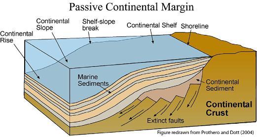
Plate 1. Schematic of a passive continental margin. This example is for a continental plate moving to the right while sediments are deposited along a gently dipping margin. As far as the data tell us, this was the situation in NWA between about 1000 and 250 Ma. The N American plate wasn’t jiggling, but rather sedately moving eastward, chewing up whatever islands and microcontinents got in its way while shedding its sediments on the west coast. (Like water off a duck’s back.)
Paleozoic (550 to 250 Ma)
The Paleozoic era saw the rise of multicellular organisms, which filled the oceans and colonized the land. There are enough fossils, the inhabitants of ancient seas in NWA, to document this explosion, but the rocks are highly altered and deformed. Nevertheless, the paleontological record implicitly supports the continuation of the passive margin that existed during the late Precambrian. In other words, a vast and diverse ecosystem was established that thrived for 300 my.
Mesozoic (250 to 65 Ma)
The Mesozoic era began with the breakup of Pangea, the supercontinent whose construction culminated during the Devonian period (415-360 Ma). This paradise of life lasted about 100 my but all good things must end. Upper mantle convection reversed course and Pangea was torn apart by what is today the mid-Atlantic ridge system. I saw the evidence in NoVA for myself; but what did this catastrophic event foretell for the peaceful west-coast of N America?
All hell broke loose.
The placid coastal environment suggested by Plate 1 was obliterated, geologically speaking, when the N American tectonic plate reversed direction and split away from Pangea, after approximately 100 my. At first there would have been earthquakes and uplift as the oceanic plate resisted the sudden compression. Nevertheless, when push came to shove, the denser oceanic crust was pushed beneath N America, creating a subduction zone that is still active.

Plate 2. This schematic portrays NWA as it exists today. Note how close the Juan de Fuca ridge is to N America. If we go back to the Triassic period (~250 Ma), there would have been about 2000 miles of oceanic crust between them, but it was all subducted. This subducted ocean crust would have partially melted to produce igneous intrusions, which were subsequently intruded by younger magma. Today, only a few slivers of the oldest igneous rocks are found east of Seattle. There were also sediments deposited; however, these were buried and deformed to form schist and other medium metamorphic grade rocks. Most Mesozoic rocks were eroded as uplift continued until the present day. Bands of Mesozoic volcaniclastic rocks are found east of the cascades where uplift has slowed as the subduction zone migrated westward.
Tertiary (65.5 to 2.4 Ma)
As the years passed the situation in Plate 2 continued unabated. Igneous intrusions of every composition (i.e. from gabbro to granite) pushed their way through the overlying rocks, often reaching the surface to create volcanoes and overlapping volcanic flows, mostly basalt.
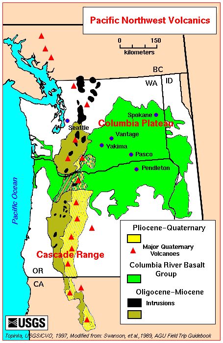
Plate 3. Map of Tertiary volcanic rocks in Washington. The oldest eruptions occurred along the Cascade range between about 50 and 2.4 Ma; the Cascades comprises overlapping volcanoes. The intrusive (black areas) and extrusive rocks from these older eruptions (brown) are weathered, the volcanoes dormant/extinct, their source plutons (buried magma chambers) exposed by erosion. The Columbia River basalts (green) flowed from fissures in the crust rather than volcanoes between 17 and 14 Ma, with ongoing weaker eruptions until about 6 Ma. These are too young for their source magma chamber to be exposed. The youngest volcanics (Yellow) are associated with active volcanoes like Mt St Helens, Mt Rainier, and Mt Hood (in Oregon). For example, Mt Rainier is about 850 thousand years old.
Quaternary (2.4 my to present)
As shown in Plate 3, volcanism has continued uninterrupted into the present time and will persist until the westward motion of N America stops; and no one knows when that might occur. Nevertheless, a new geological phenomenon occurred about 2.4 my ago, which delineates the Quaternary from earlier geological periods.
Earth was plunged into an ice age, which continues to this day, even if we are in an interglacial interval. It isn’t obvious why ice ages happen, but they have occurred many times throughout earth history: Pongola, 2900-2780 Ma; Huronian, 2400-2100 Ma; multiple events between 715 to 547 Ma; Andean-Saharan, 450-420 Ma; Karoo, 360-289 Ma; Late Cenozoic, 34 Ma to present. The primary glacial period represented in NWA is the most recent.

Plate 4. Map of estimated ice thickness in feet during the last glacial maximum in NWA. The ice skirted the active Cascades volcanic complex and followed the Puget Sound Trough, carving the deep bays and channels we see today. Note that the ice was 2400 feet thick over present-day Tacoma. The ice encountered bedrock beyond this corridor and was constrained. Note the location of Puget Sound between the Cascades and the Coast Range in Plate 2. An elongate basin like this is created by buckling of the crust, forming what is termed a forearc basin, which created an easy path for advancing ice sheets.
Over millions of years the ice advances and retreats many times while continuously eroding soil and rock, carving valleys, depositing broad layers of sediment beneath it where rivers flow, causing the crust to subside under its weight. Whereas the ice thickness can only be estimated, the layers of sediment deposited by a glacier can be measured directly.

Plate 5. This simplified diagram shows the thickness and provenance of glacial deposits near Tacoma, which rests on bedrock (deformed Tertiary sedimentary rocks). The total thickness here is about 600 feet, deposited over several million years. The spatiotemporal variation in depositional environments creates outwash during advance and recession, lakes in front of the glaciar, windblown loess and till, streams draining the bottom of the glacier as well as meltwater, to name a few. This rapid switching of depositional environment leads to juxtapositions of coarse and fine-grained sediments in both time and space.

After more than 10000 years since the last glacial retreat, the crust has bounced back, rivers have been created and cut into the glacial sediments, and you have a waterway comprising hundreds of islands, its margin defined by steep bluffs (~100 feet) cut into unconsolidated glacial deposits.
That brings us up to speed…
Coast to Coast
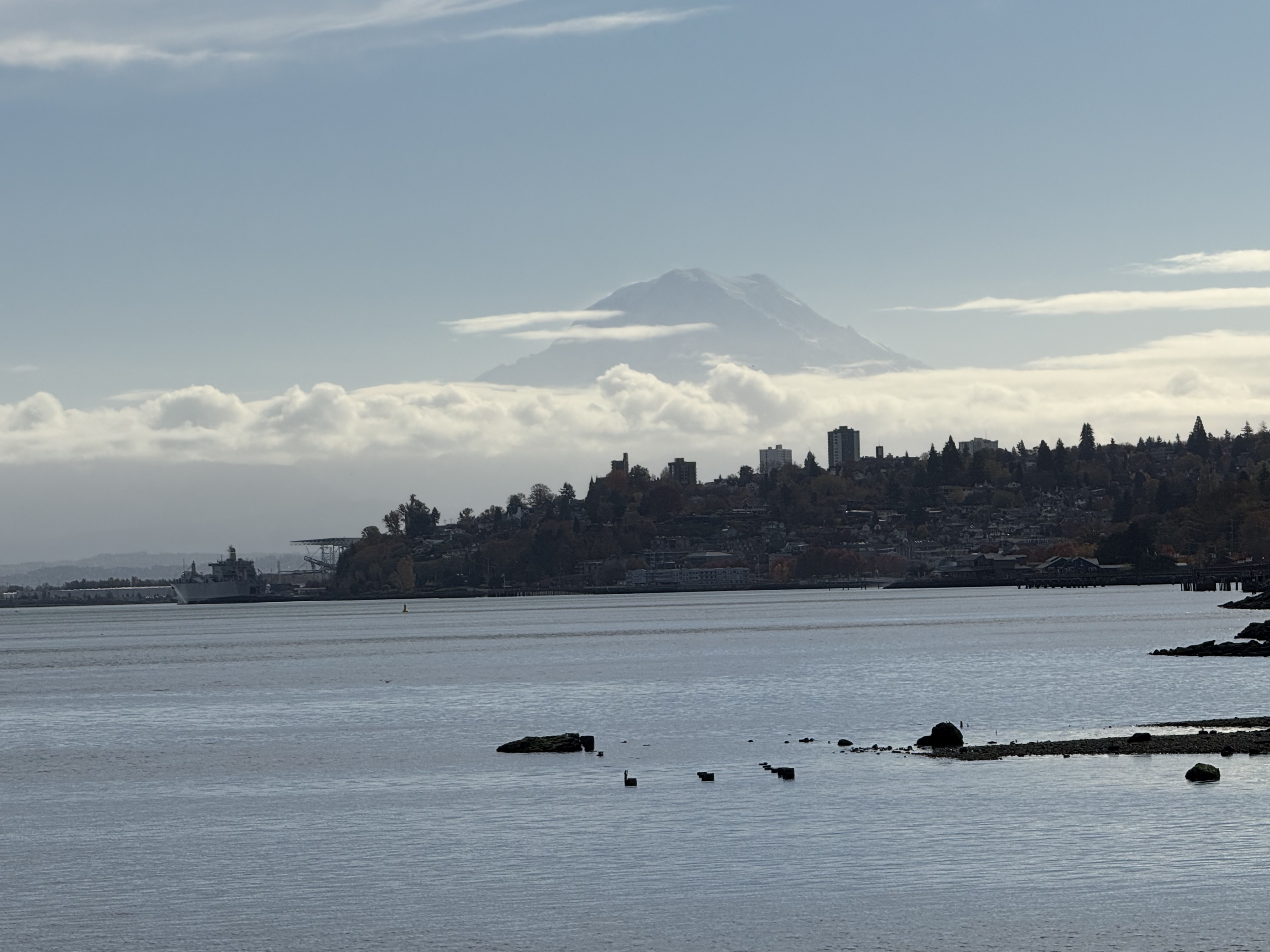
Plate 1. We’re not in Northern Virginia anymore!
I’ve relocated to the west coast–Tacoma, Washington to be exact, and that active stratovolcano looming in the background is Mt Rainier (aka Tahoma as it’s known to the indigenous people). The pristine water body is Commencement Bay at the southern end of Puget Sound. Mt Rainier is 14410 feet high, which makes it the most topographically prominent mountain in the lower 48 states; for scale, it is 43 miles from Tacoma, yet dominates the SE horizon. How did it come to be so close to the coast and yet so tall? Before I answer that question, let’s recap the geological story of NoVA that I pieced together over the last four years.
Over a billion years ago, NoVA was submerged beneath an ocean or marginal sea. Distant mountains eroded rapidly in a time before land plants. Vast quantities of sediment accumulated in layers of erosional debris that were subsequently buried by younger sediment. Between a billion and five-hundred million years ago, these sediments became rocks that were subsequently deformed as continental plates collided. They didn’t melt, however, and survived the cataclysm relatively unharmed, becoming schist and related metasedimentary rocks.

Plate 2. This schematic cross-section of the US East Coast is representative of NoVA. It shows the final closing of the Iapetus Ocean (forerunner of the Atlantic), which would have produced immense quantities of terrestrial sediments (e.g. the Devonian Catskill Delta in panel B). Unfortunately, these river and lacustrine sediments were subsequently eroded in NoVa as the ensuing mountains grew in size (panels C through E). They are today preserved in western New York State and eastern Pennsylvania. What survived in NoVA are older metasediments, ranging from ~1200 to 500 Ma, which were buried beneath the material eroded along the western margin of this figure (the yellow areas). Some Devonian intrusive rocks, intruded into older metasediments, survived along the Potomac River.

Plate 3. This reconstruction of the supercontinent, Pangea, coincides with Plate 2E. The square indicates NoVA. Pangea began to crack apart ~210 my ago, split by a spreading tectonic plate boundary, and for the last 200 million years, the older rocks have been slowly working their way to the surface as younger rocks were removed by erosion. They are now exposed to the elements and are weathering to form new layers of sediment in the Atlantic Ocean, beginning a new cycle.
What about the northwest coast, Tacoma and Seattle, you may ask?

Plate 4. This beautiful schematic cross-section represents the consensus opinion of geologists familiar with the Cascadia region. Tacoma lies at the northern end, near Mt Rainier. I will refer to this image frequently in my following posts. Study it a moment and you will realize that the geologic situation is similar to that presented in Plate 2A and B, but on the eastern (right) side of the closing ocean basin, i.e., the Pacific Ocean.
The Coast Range (including Olympic peninsula) is part of the accretionary wedge of a subduction zone, and Puget Sound lies within the forearc basin. In other words, I have moved from an extinct collisional tectonic regime to an active SUBDUCTION zone; Mt Rainier (Plate 1) is the tip of the geological iceberg, leaking sweat from the partially melting Juan de Fuca tectonic plate.
I hope you join me on this new geological adventure into the past…
Geological Cycles at Wolf Trap National Park

Figure 1. (A) Wolf Trap National Park for the Performing Arts is located about twenty miles west of Washington DC, near several parks I’ve discussed in previous posts, especially Great Falls National Monument. The geology of the area is dominated by Neoproterozoic-to-Cambrian (1000 – 511 Ma) metasedimentary rocks that originated in oceanic environments near rapidly rising mountains (e.g., a volcanic island arc). The dates are from the time of metamorphosis, which is why they give such a long time span. Taking into account the accuracy of the dates in general, this region was undergoing erosion with the resultant sediment buried in marine trenches, probably near a subduction zone, for hundreds of millions of years. The majority of the material would have been mud. There would have been hiatuses (perhaps an ocean basin briefly emerged), but such detail is lost to us after so long. (B) This map of Wolf Trap Park shows the trail we followed. The map doesn’t show topography, but the ridges are short, with maximum relief less than 100 feet. Wolf Trap creek enters from the west (left side of panel B) and flows through a wetland area (indicated by blue ellipse) before meandering a little and following the east side of the valley.
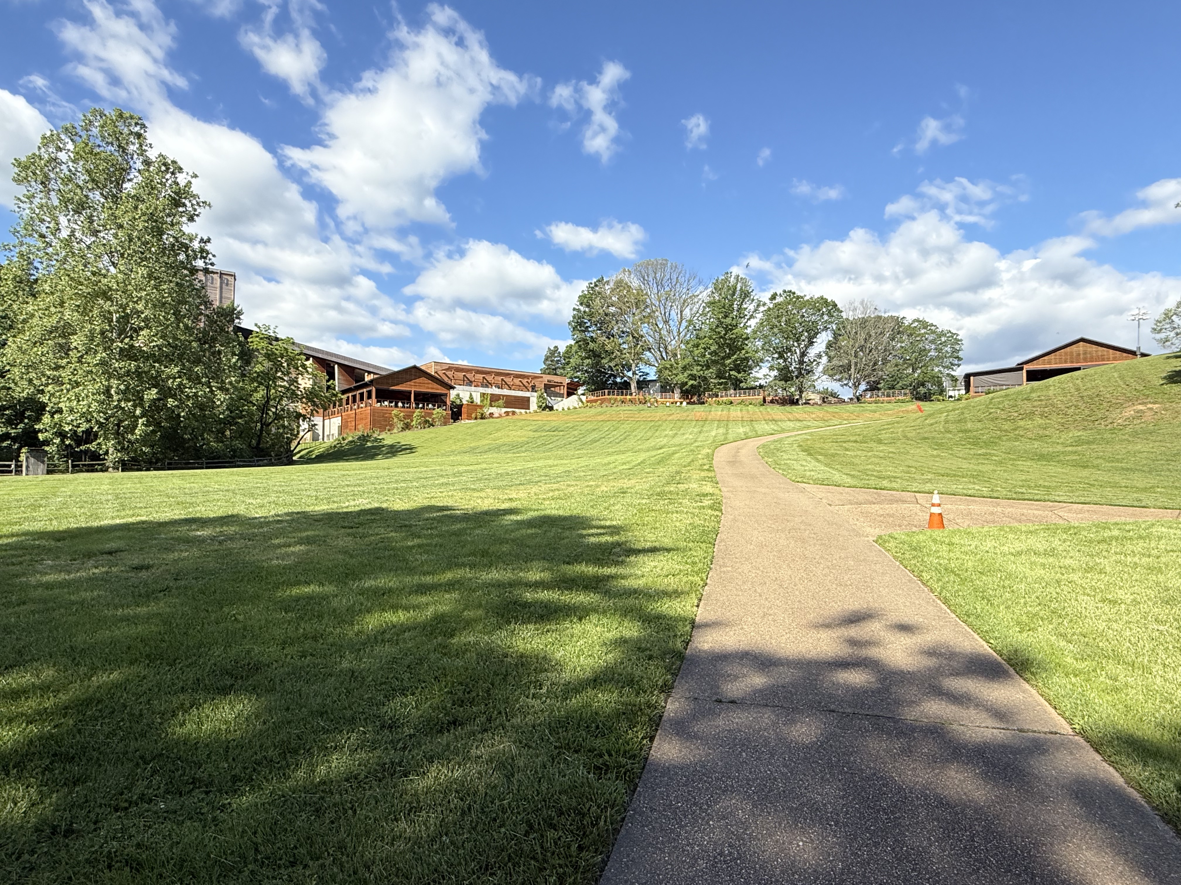
Figure 2. View of Filene Center from the SW side of our trail loop (see Fig. 1B), showing typical topographic relief at Wolf Trap park.

Figure 3. View of Wolf Trap creek where it enters the valley (Fig. 1B), showing boulders of Precambrian schist to be blocky–eroded nearby and gravitationally slid into creek but were not transported. These recently exhumed blocks are covered by Quaternary fluvial sediments, which are visible along the left side of the creek.
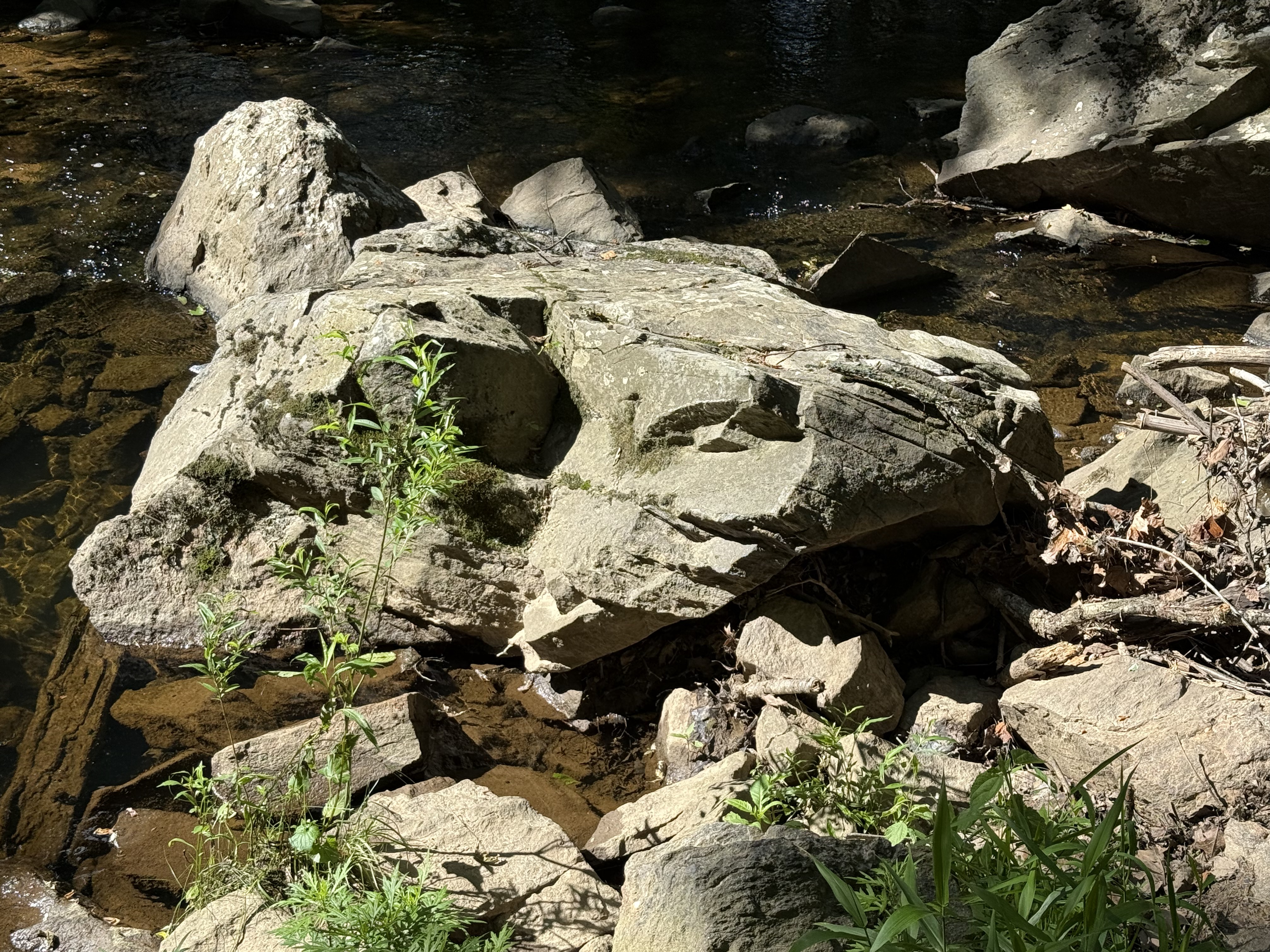
Figure 4. Large block (less than 6 feet in diameter) of schist that has been moderately weathered in place. Note the thin bedding (fissility) between thick layers with a conchoidal fracture pattern (center of image). This is the upstream side, which is pockmarked by rolling and bouncing boulders during high water. Mud becomes schist when buried deeply, retaining the lamination of the original fine-grained sediments, but remineralizing to familiar clays easily at the surface. Mud to schist to mud.

Figure 5. Meander in Wolf Trap creek along the north side of the park (see Fig. 1B), where a shallow pool of quiet water collects between runs (turbulent creek segments).

Figure 6. View looking upstream from a pedestrian bridge crossing Cthse Spring Branch, a tributary crossing our trail (dash line in Fig. 1B) before it joins Wolf Trap creek (NE side of trail in Fig. 1B). The boulders are smaller than downstream (Figs. 3 and 4), and their long axis are aligned with the stream flow. These angular blocks are sliding along on a stream-bed comprising miniature versions of themselves (note the clear view of the bottom in center of image). Even gravel and pebble-sized particles are platy because of the characteristic fissility of schist.

Figure 7. This photo dramatically reveals the effect of water on erosion.

Figure 8. This image is one I’ve seen too often here in northern VA. The sewer systems frequently follow streams because they are low points and run downhill (a good property for a sanitary system). However, when stream levels exceed expected values, the system is compromised and raw sewage can be released into the environment.
Summary. Over a billion years ago, this area was submerged beneath an ocean or marginal sea. Distant mountains eroded rapidly in a time before land plants. Vast quantities of sediment accumulated in layers of erosional debris that were subsequently buried by younger sediment. Between a billion and five-hundred million years ago, these sediments became rocks that were subsequently deformed as continental plates collided. They didn’t melt, however, and survived the cataclysm relatively unharmed, becoming schist and related metasedimentary rocks. For the last 200 million years, they have been slowly working their way to the surface as younger rocks are removed by water erosion in streams like we see all throughout NoVA. They are now exposed to the elements and are weathering to form new layers of sediment in the Atlantic Ocean, beginning a new cycle.
Washington Monument State Park, MD: Familiar Cambrian Metasediments
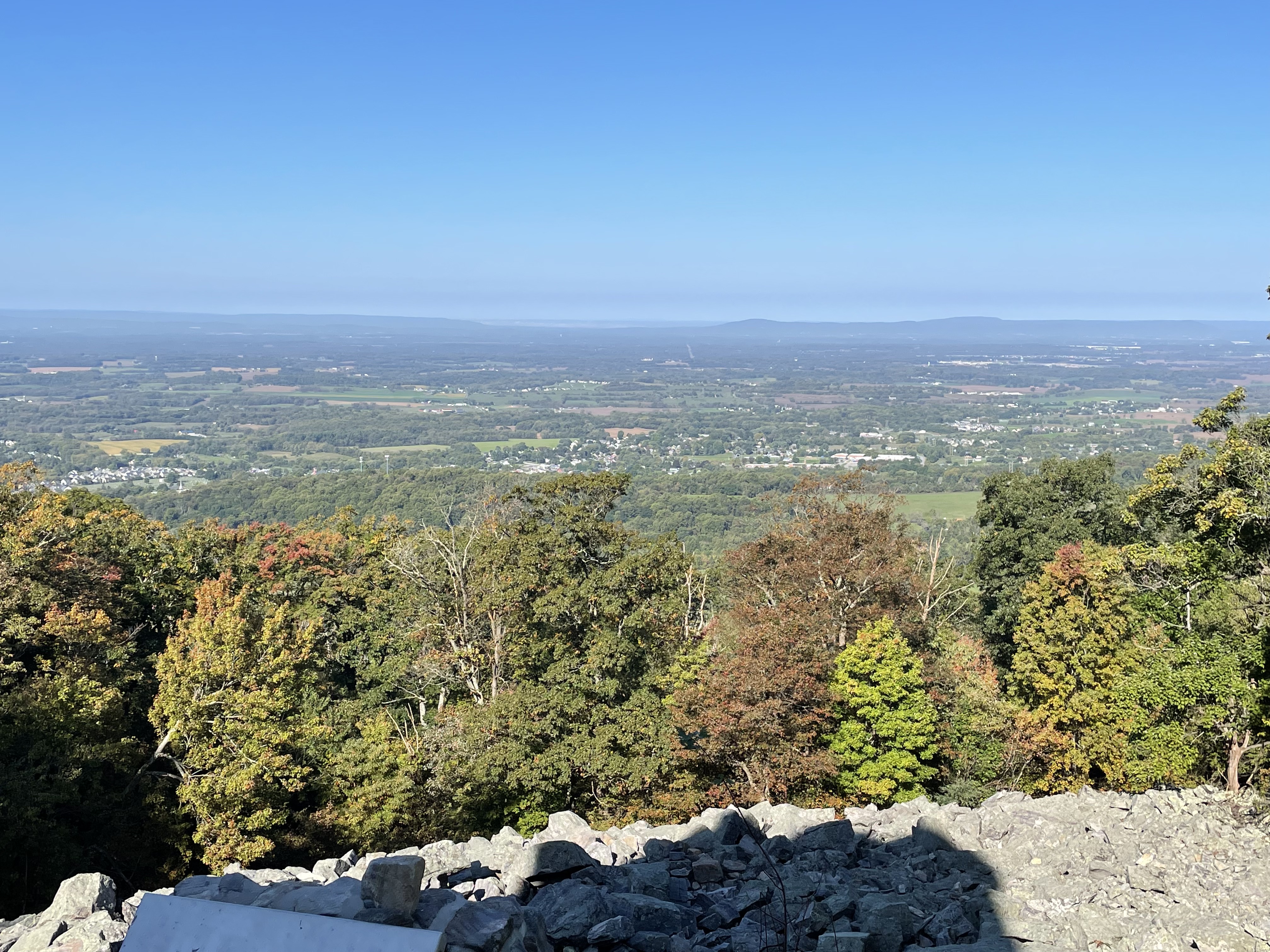
Figure 1. Looking west from Washington Monument, atop the Blue Ridge in Maryland. The valley is equivalent to the Shenandoah Valley in VA (see Fig. 2), but I couldn’t find a map with it labeled. The Appalachian trail follows the ridge through MD; we encountered it a few miles south of here in a previous post. We expect to see some of the same Proterozoic-to-Cambrian (2500-500 Ma) metasedimentary rocks here that we saw before, in addition to a surprise from an older post.
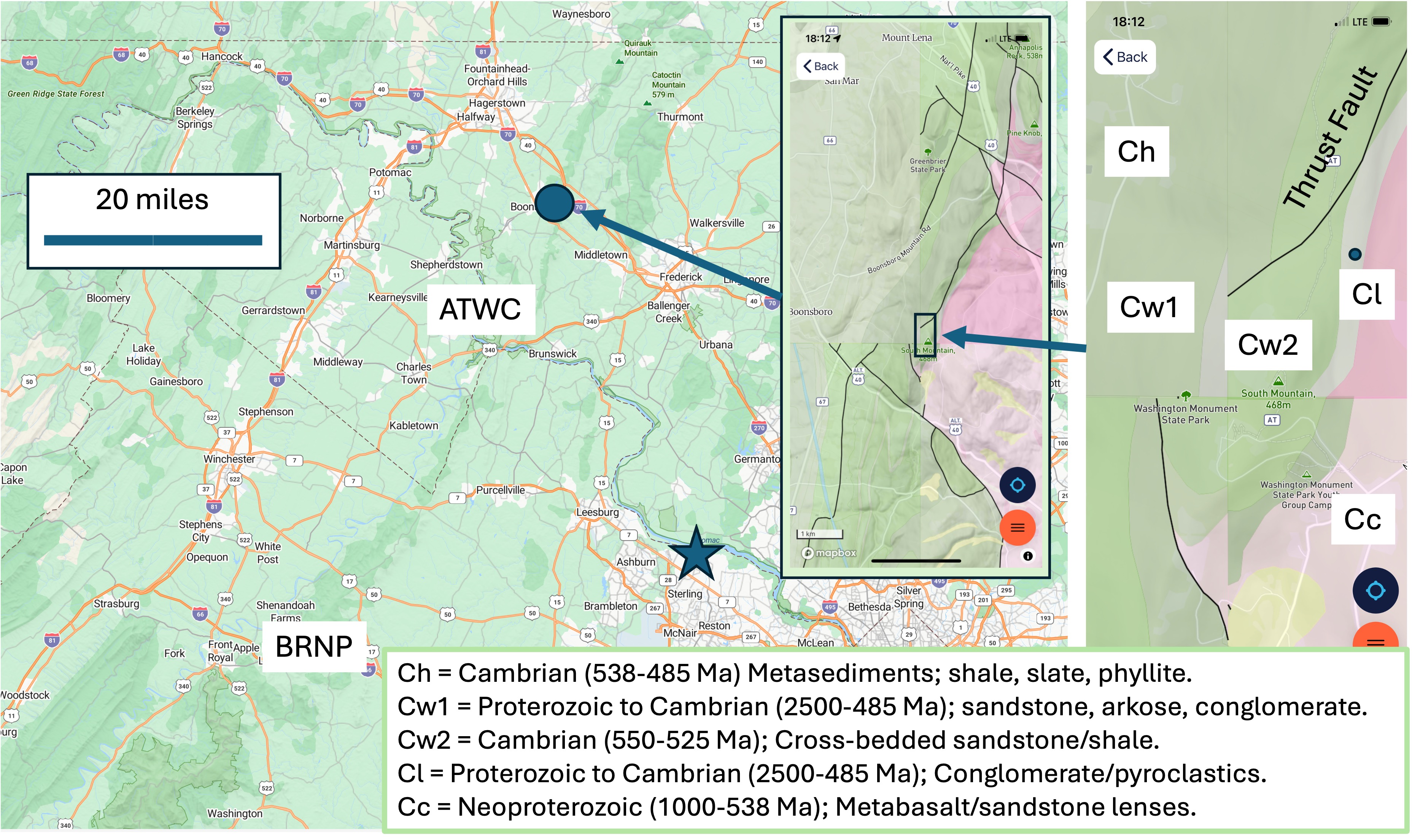
Figure 2. The field site. Washington Monument is indicated by the purple circle and arrow in the large map. The first inset map shows the geology around the monument. Note the mismatch in geology from different quadrangles; this must be a problem with either the data or Rock D, but the units (indicated in the smaller inset map to the right) were consistent when I clicked on a point. My home is indicated by the star, so you can see we haven’t traveled far. ATWC refers to the Appalachian trail at Weverton Cliff, MD, which I recommend you read to get some background. BRNP represents Bull Run Nature Preserve, which I posted last year. The geological legend for the detailed inset map is at the bottom of the figure. Note that Ma stands for a radiometric age of one-million years; this age is indicative of cooling below the threshold to set the atomic clocks within the minerals, but sedimentary rocks can’t be dated this way. Therefore, these are dates when deep burial and/tectonic deformation/magmatism ceased (i.e. when an orogenic period ended).

Figure 3. Rubble near the monument that resulted from in-place weathering of Weverton Formation rocks (Cw1 and Cw2 in Fig. 2). All of the weathering products (e.g. clays and carbonates) have been washed away, leaving large slabs (~6 feet) piled up. This is a common feature of rocky knolls with good drainage.
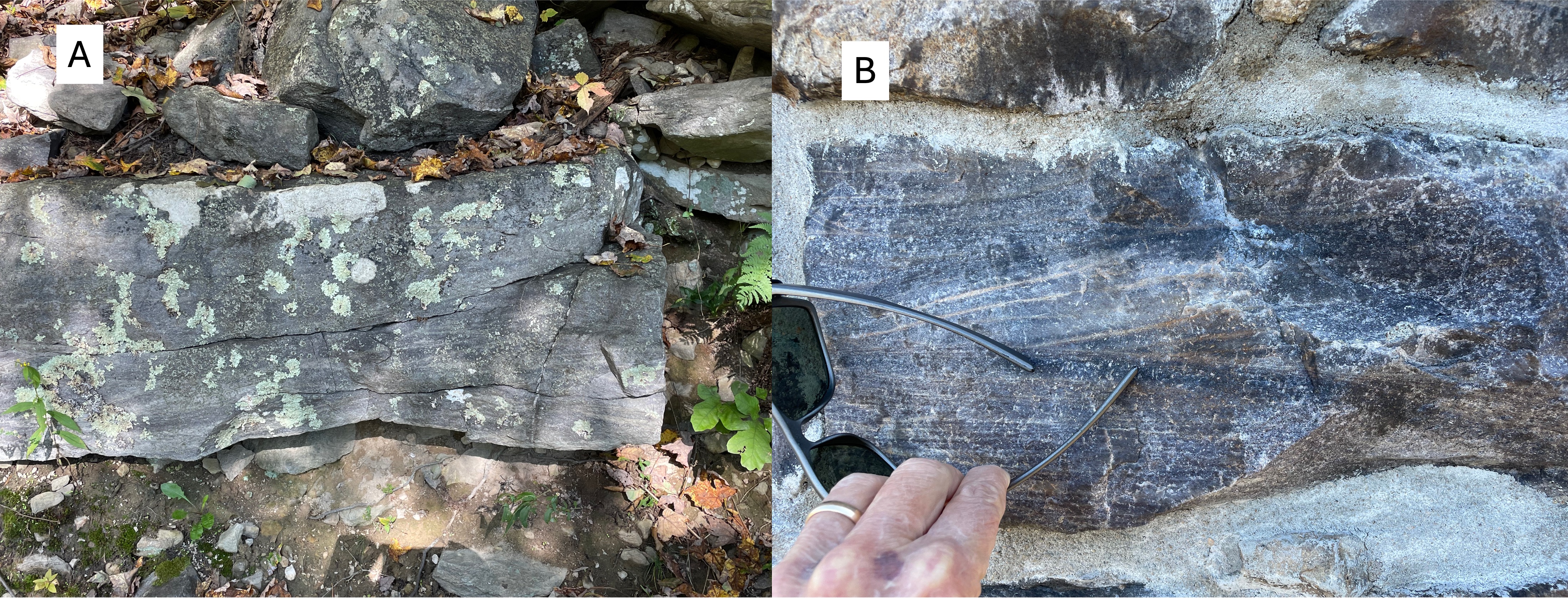
Figure 4. (A) Outcrop of older Weverton formation rocks (Cw1 in Fig. 1), revealing weathered material below and boulders on top. This outcrop contains cross-bedded layers on close examination. (B) Photo of a block of Cw1 used in the monument , which shows the crossbedding better than panel A because a fresh surface was cleaved during a recent repair of the 30-foot tower. The color is important: green sedimentary rocks like these represent marine environments, where there is less oxygen; sedimentary rocks deposited in rivers tend to be reddish because of oxidation (rusting) of Fe-containing minerals. These are probably shallow marine sands.

Figure 5. (A) Quartz in a vein (<1 inch thick) from near the monument. Note that the cross-bedding is very similar to Fig. 4 but more weathered. (B) Less-common view of a quartz vein seen obliquely, showing the surface that was against the country rock. These veins would have been injected during a period of magmatism, sometime between 2500 and 511 Ma; I can’t be more specific because I don’t know exactly where the radiometric ages were measured within these rocks. However, the Weverton formation is approximately 4500 feet (1.4 km) thick here; thus it’s possible that these rocks were deposited episodically during this immense time interval; but no unconformity (i.e. erosion or non deposition) is mentioned in RockD.

Figure 6. View looking east from the Appalachian Trail, showing the terrain typical of the Appalachian foothills. To the left of center, outcrops of Weverton rocks (Cw1 and Cw2 in Fig. 2) can be seen.
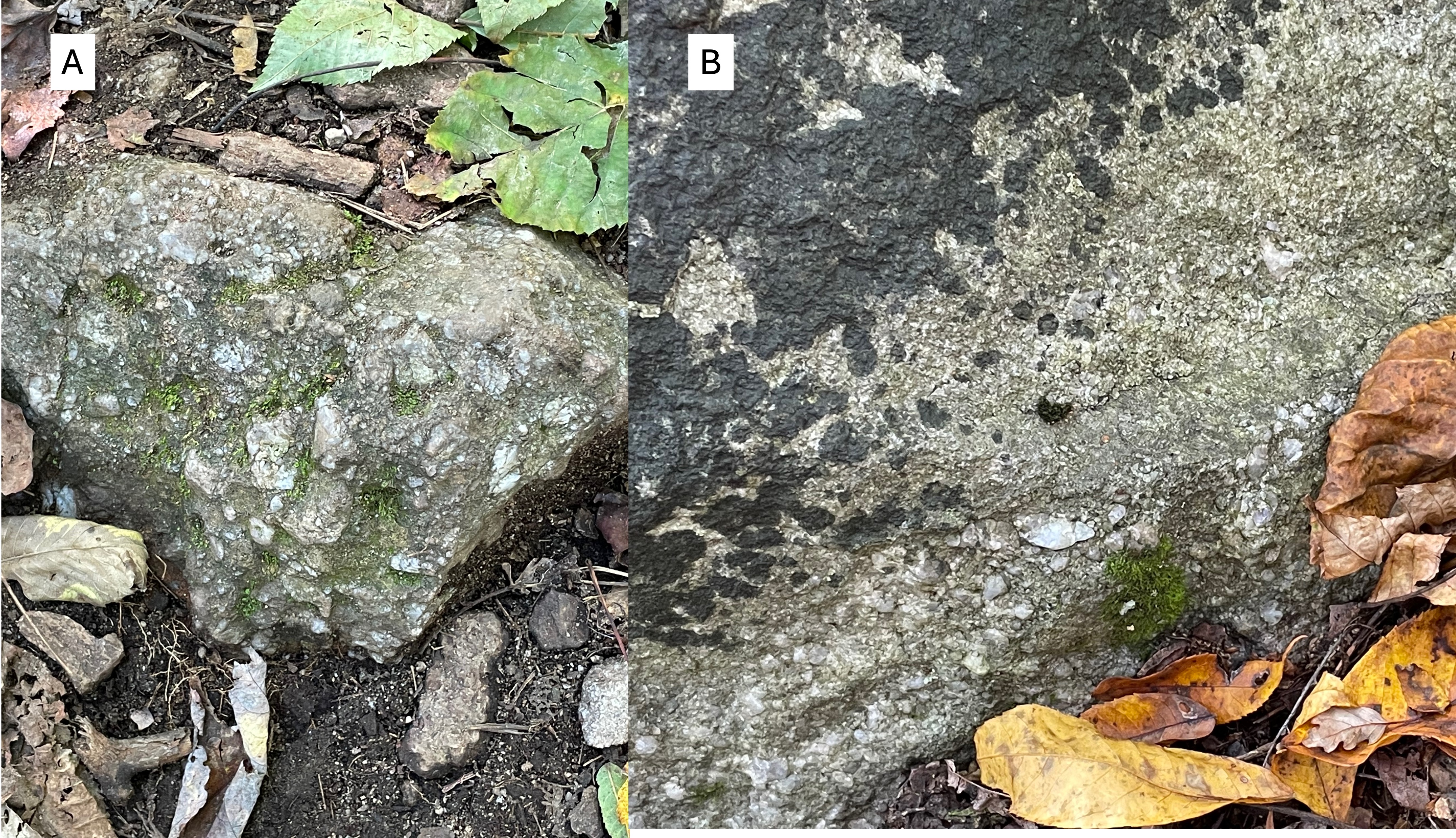
Figure 7. (A) Boulder (~2 feet across) of arkose, revealing angular clasts of rock fragments in a sandy matrix. (B) Poor outcrop of conglomerate with rounded rock and quartz in a similar, sandy matrix. Comparing these images to Fig. 4 shows the variability of sedimentation (and thus depositional environment) during relatively short time intervals (say … tens of millions of years, for example). This kind of variability implies changing sediment sources, possibly caused by tectonic uplift (with magmatism) to the east.

Figure 8. This figure is from the Bull Run Nature Preserve field trip. It is a schematic of how layers of sedimentary rocks (shown in different colors) can slide over one another along thrust faults. This process results in stacking of similar sediments, making stratigraphic analysis of sparse field data problematic. The rocks on the left are sliding upward to the right along a series of thrust faults (dashed line). At Bull Run Nature Preserve, a fault like this could be identified by older rocks clearly being stratigraphically higher than younger ones. That isn’t the case at Washington monument, where the interleaved rocks (blue and green) are too similar in lithology and age to be differentiated.
SUMMARY
The thrust fault labeled in Fig. 2 has been confidently identified (represented by a solid line), no doubt through more investigation than I was willing to spend time on. This unnamed fault underlies the northern Blue Ridge, and marks the beginning of the Valley and Ridge province; the Blue Ridge was thus an anomaly, which has been identified as a belt of older rocks thrust over younger ones about 500 million-years ago, when the supercontinent of Pangea was being created.
We have followed the Weverton formation through time (2500-485 Ma) and space (more than 40 miles). During this unimaginable interval, this small piece of the Earth’s crust has moved thousands of miles. Only the last 500 my of its journey is known with any confidence. This tectonic plate has been carrying these sediments to unknowable latitudes, colliding with immovable objects while spreading the remnants of mountain ranges that are now forgotten, deconstructed by the irresistible power of water, wind, ice and time.
Some things aren’t meant for us to know …
Turkey Run State Park

Figure 1. View looking upstream in a small creek flowing into the Potomac River (see Fig. 2 for location). The hills are covered with a thin veneer of fine sediment deposited on Proterozoic and Paleozoic (i.e. 585-443 Ma) rocks. This image shows several ledges of this basement rock, which is the topic of this post.
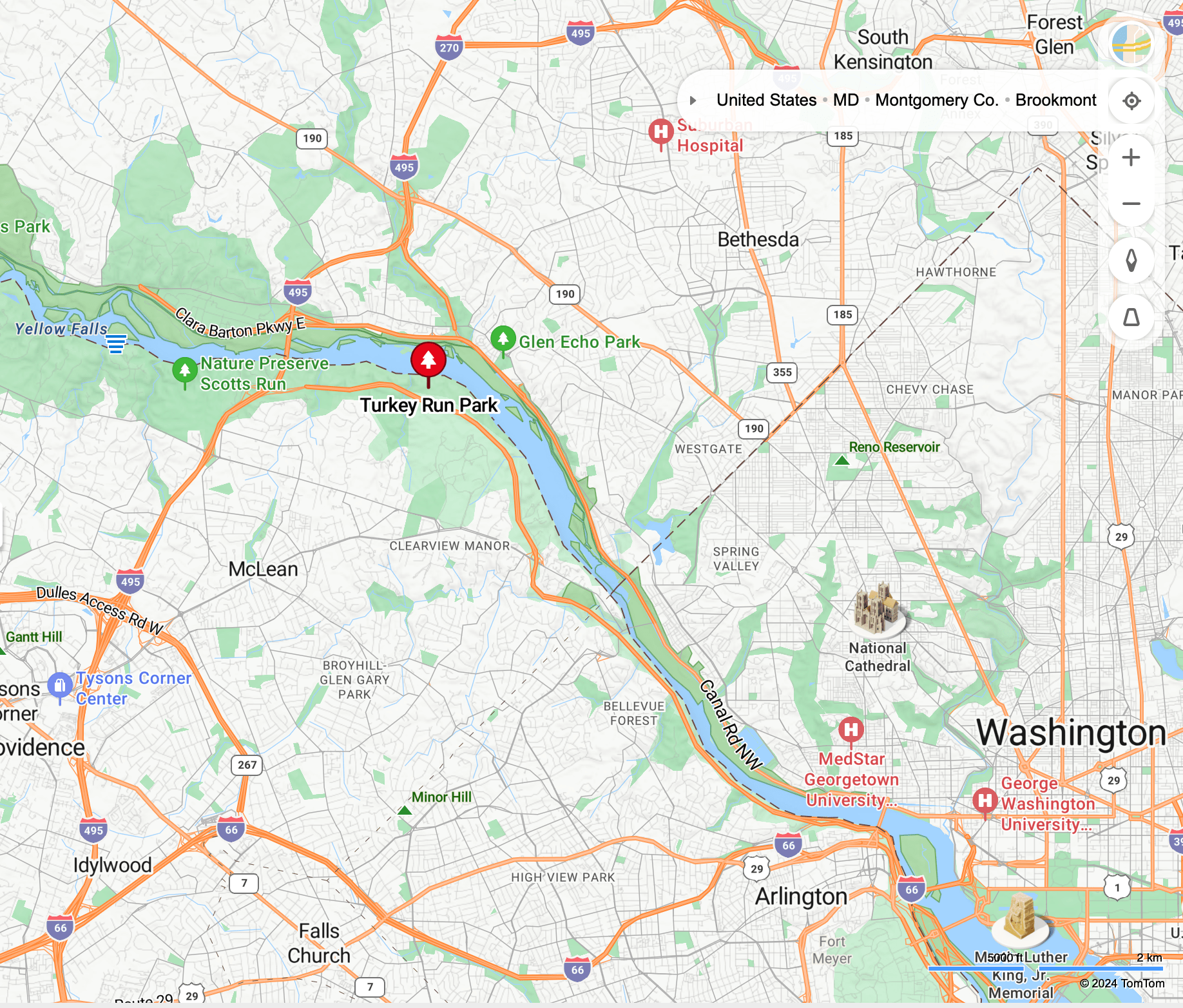
Figure 2. Map showing Turkey Run Park relative to Washington DC. Further upstream, at Scotts Run (labeled on the map), we saw Proterozoic (2500 – 542 Ma) metamorphic rocks.
INTRUSIVE ROCKS

Figure 3. Outcrop of the Ordovician (488-423 Ma) tonalite, a medium-to-coarse-grained intrusive rock. Tonalite contains little or no quartz. This is a typical exposure in this area. This rock doesn’t form cliffs and the river isn’t contained within a narrow gorge as we saw further upstream. Large blocks have fallen away as the low and irregular bluffs erode. We’ll examine this tonalite in closer detail next.
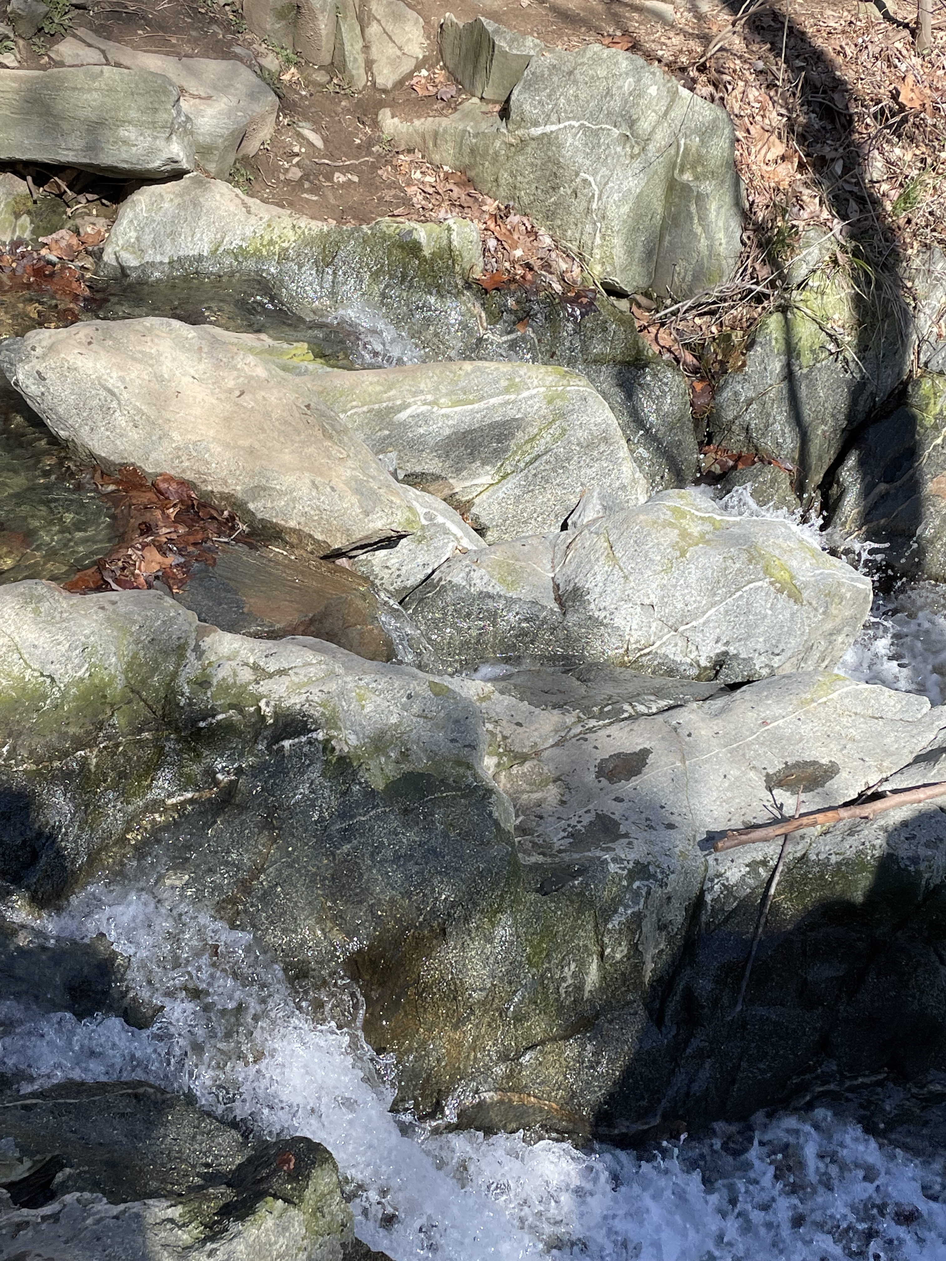
Figure 4. Tonalite exposed further downstream from Fig. 1. Note the veins of light-colored minerals running through the rock. These are veins of quartz that filled fractures in the magma after it had cooled, but was still above quartz’s melting temperature. These veins are irregular because intrusive rocks aren’t layered like sedimentary rocks; they probably also reflect slow deformation of the semisolid magma on geologic time scales (i.e. millions of years).
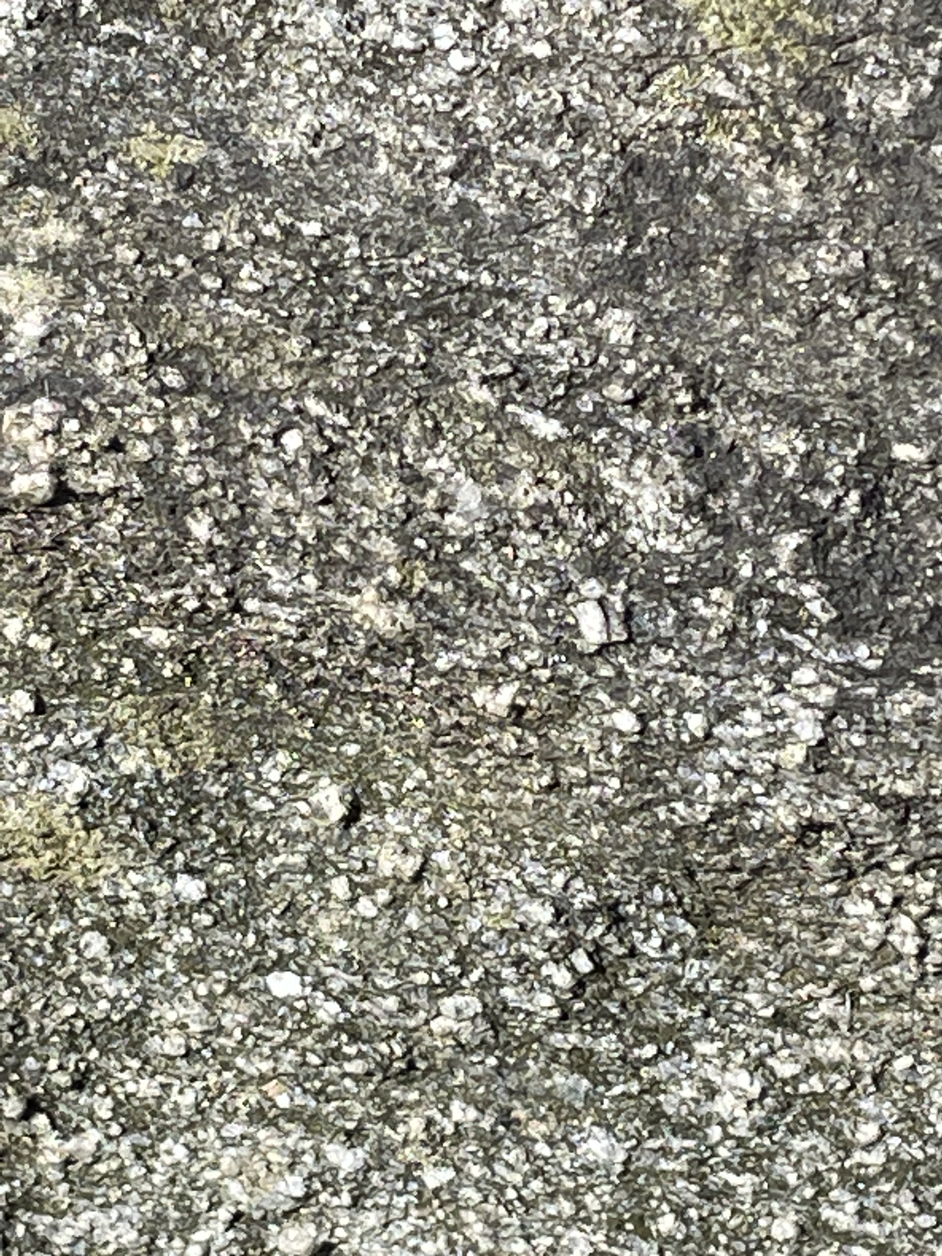
Figure 5. Close-up of tonalite (image about 2 inches across), showing rectangular feldspar crystals and darker biotite and hornblende, which make up about half the composition. The darker minerals weather faster than the feldspar, leaving the latter protruding from the surface. This image also shows a slight foliation, running from the upper left to lower right. Foliation in igneous rocks can be syndepositional (i.e. as the magma cooled) or created when the solid rock is reheated enough to deform without breaking. I think these rocks fall in the first category.
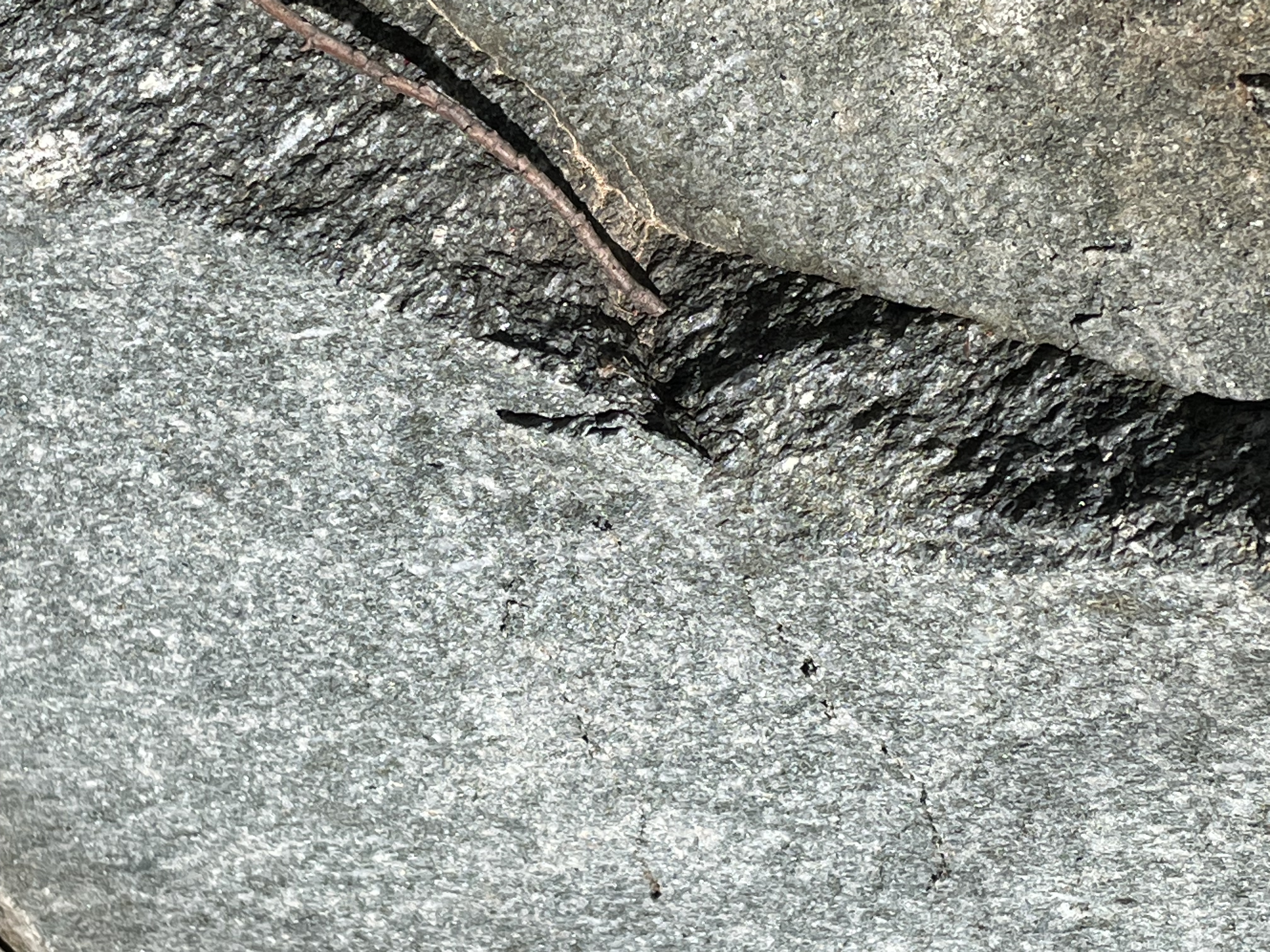
Figure 6. This unusual image shows a layer of foliated tonalite sandwiched between two blocks that appear undeformed. This is probably an illusion caused by irregular weathering; however, Rock D reports this rock unit as containing fragments of older rock and previously solidified tonalite. The emplacement of a large batholith takes tens-of-millions of years to complete, during which time there was probably considerable crustal shortening associated with collisional plate tectonics. (Honestly, I wish I hadn’t taken this photo because it is really strange …)
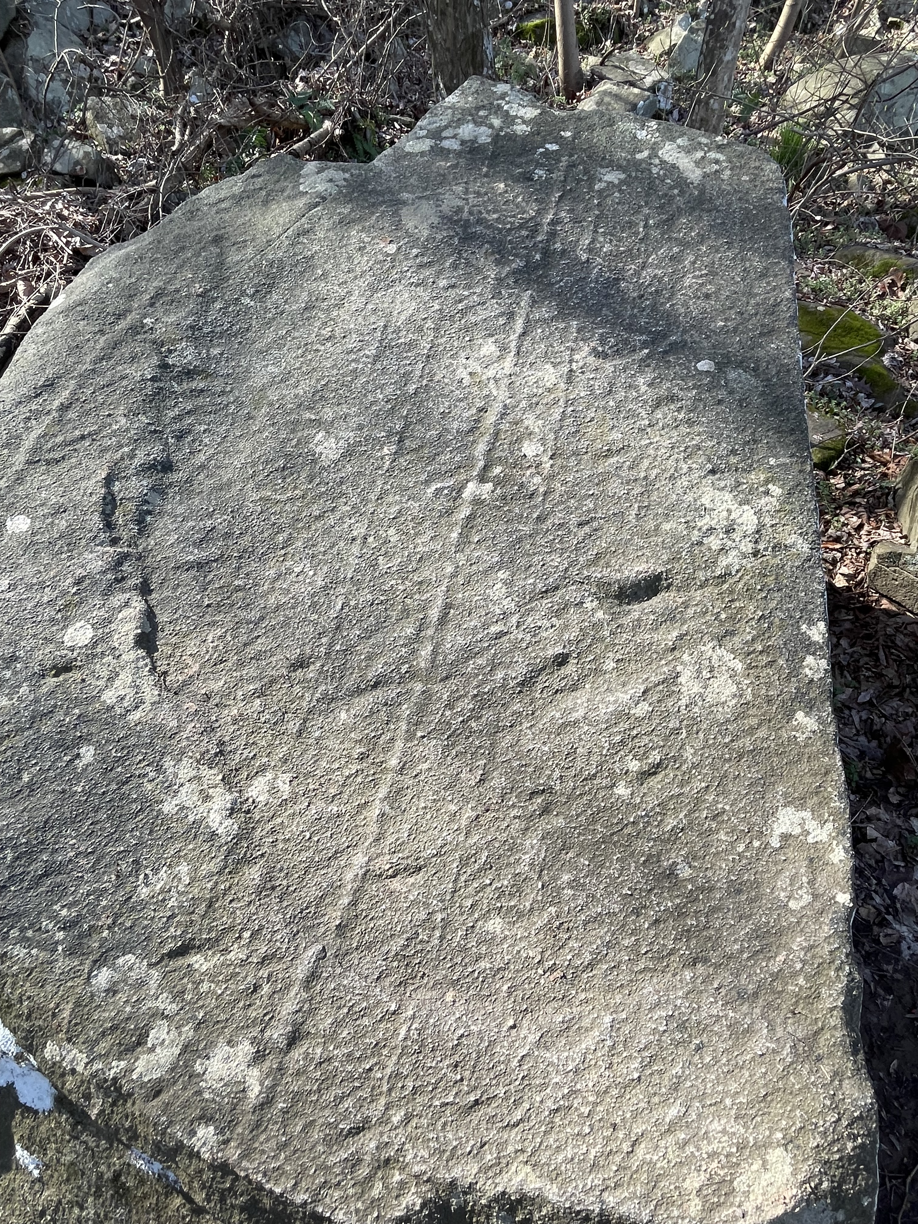
Figure 7. Joint surface within the tonalite. Joints form when the magma has solidified and is brittle, tens if not hundreds of millions of years later. These joints were almost perfectly symmetrical, with 90 degrees between intersecting planes. Such an orientation suggests that the stress regime was uniform (horizontally and vertically). In other words, they occurred during uplift (isostatic stress regime) and not during an orogeny, i.e., they occurred a long time (geologically) after the events these rocks record.
METASEDIMENTARY ROCKS
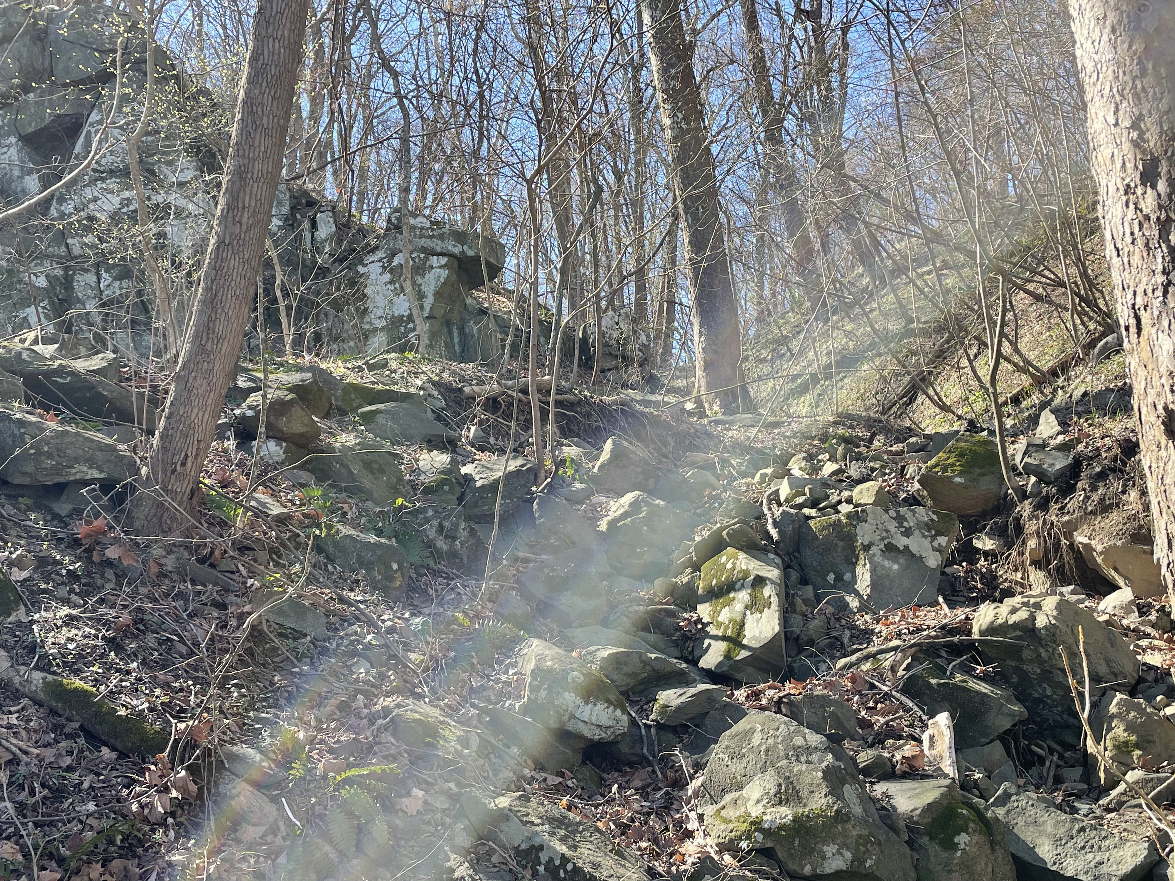
Figure 8. This photo shows the approximate contact between the Ordovician intrusive tonalite and the older, overlying Cambrian (542-488 Ma) metasedimentary rocks (intrusive rocks come from deep within the earth). The boulders lying around are mixed lithologies, representing the two rocks. Whether the stream flowing towards the camera followed the contact (they are often weak points) or not is an open question.

Figure 9. Exposure of the Cambrian Sykesville Formation metasedimentary rocks into which the tonalite was intruded. These rocks were deposited in an ocean floor/deep-sea trench environment millions of years before they were buried deeply and heated enough to be metamorphosed. Their geologic age is uncertain but Rock D reports an age of 497-470 Ma. Considering that they had to be deposited and buried before being metamorphosed, it is reasonable to assume that they were deposited about 540 million-years ago. The tonalite age of 485-443 Ma is on firmer ground because this is an intrusive rock that can be dated by radioactive isotopes trapped in the minerals comprising it. Nevertheless, their ages overlap, which requires some explanation. Such large age ranges reflect the errors associated with dating rocks this old, but also the duration of orogenic events (I’ll get to that later). I tend to trust the oldest age reported because, when radiometric daughter products (used to calculate ages) escape from the rock, the apparent age will only decrease; thus I think the tonalite was intruded sporadically starting about 485 million-years ago. Note that the bedding is tilted to the right, which is to the west; I didn’t measure strike and dip, but the orientation is consistent with regional trends — dipping to the WNW at about 35 degrees.
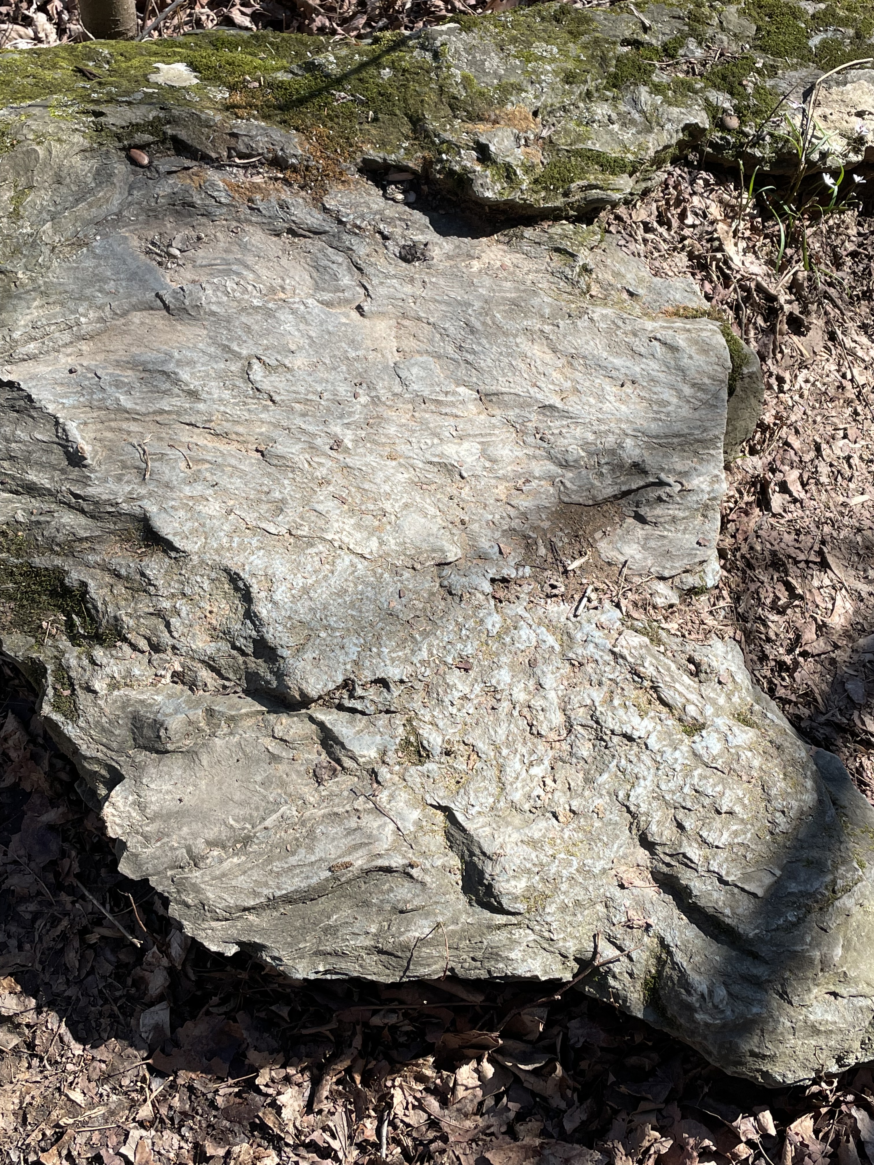
Figure 10. Original bedding plane of the metasedimentary rocks. The lumpy surface is very similar to muddy sediments in modern submarine fan and trench settings, where sediment slides down steep slopes. Any fossils (if there ever were any) were destroyed during metamorphosis, which contributes to the dating problem I alluded to above.
FIELD RELATIONS
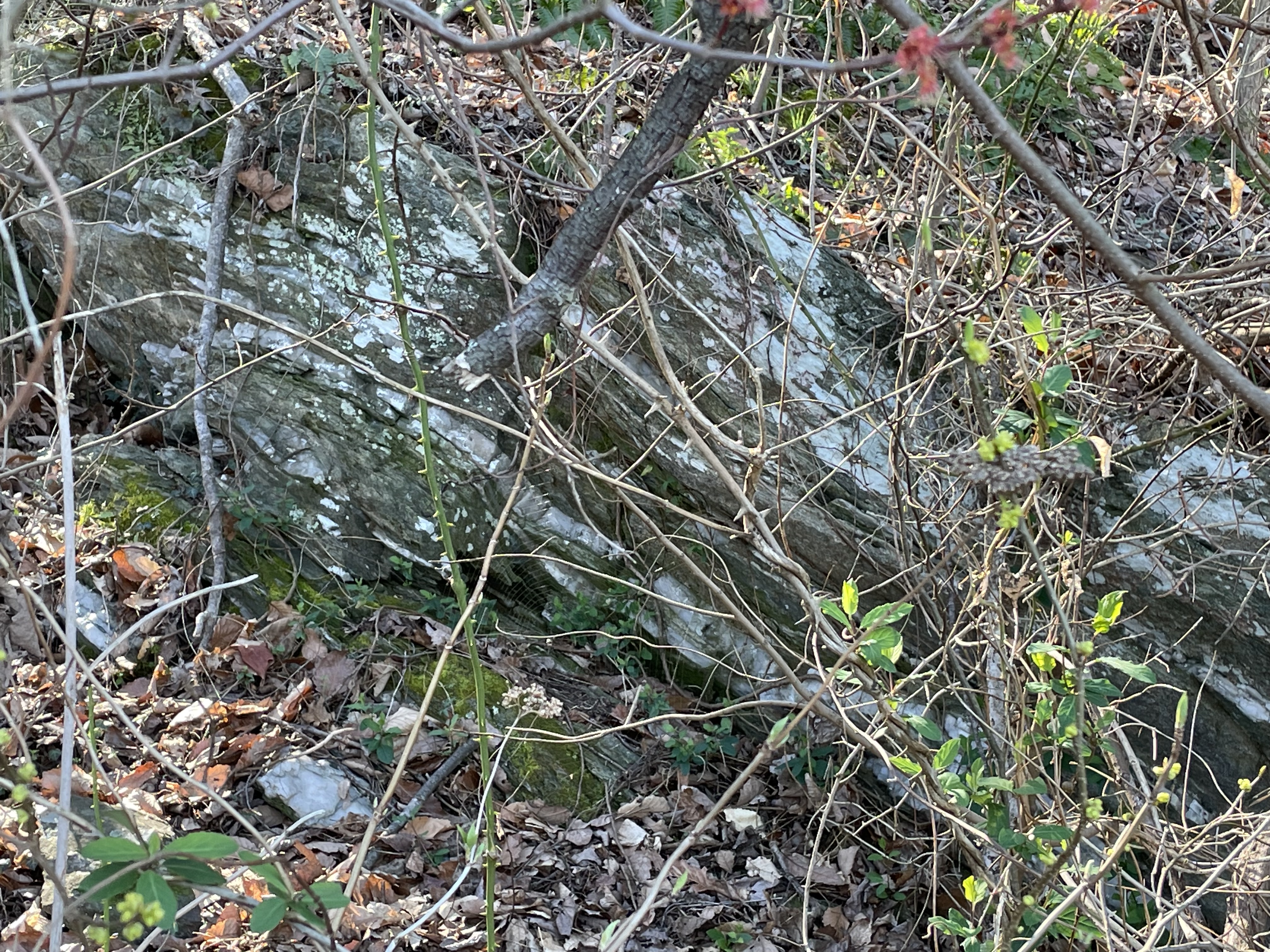
Figure 11. Exposure of the metasediments, showing light-colored layers within the darker beds of these rocks — exemplified by the thin layer just below the tree leaning to the right in the center of the photo (No, I didn’t tilt the camera; the tree is growing like that).

Figure 12. Photo of a block that fell away from the exposure seen in Fig. 11. This is mostly quartz but it contains several elongate fragments of metasedimentary rock. Although tonalite contains very little quartz, the original magma contained enough silica (Quartz is SiO4, pure silica) that magmatic fluids high in silica were infused into the overlying rocks as the magma cooled. Note that the country rock didn’t melt but was broken off during injection.

Figure 13. Exposure of a quartz-rich area within the metasedimentary rock.
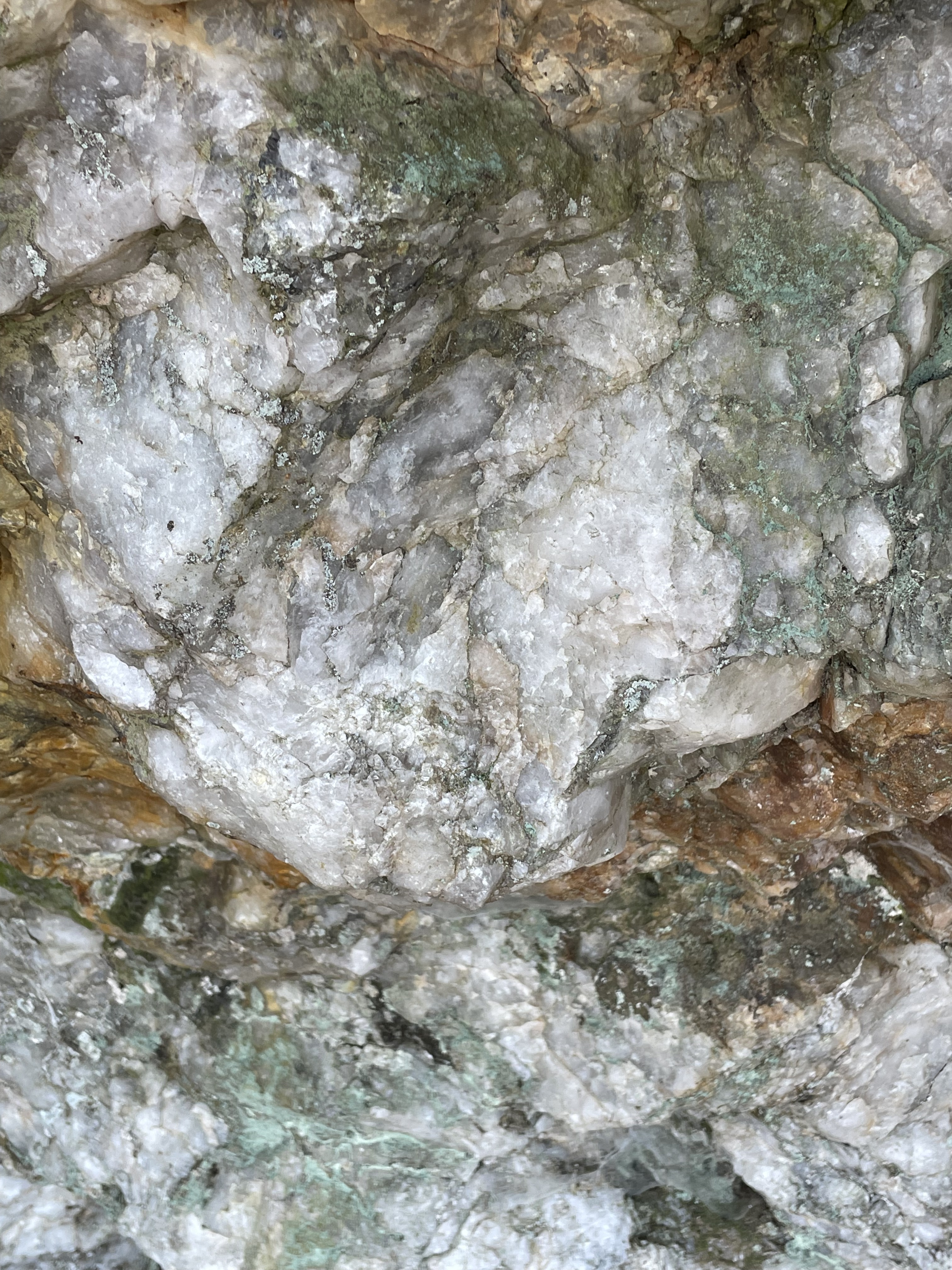
Figure 14. Close-up of the exposure in Fig. 13, showing large quartz nodules. The red stains come from oxidation of iron-rich sediments in the country rock. The image is about two-feet across. The magma didn’t contain an abundance of rare-earth elements, but this looks like a pegmatite to me. Pegmatites form from excess quartz and other incompatible elements (e.g. lithium, tantalum, molybdenum) that remain in the last bit of semifluid as the magma cools; thus they are injected into the country rock as veins following weak zones (e.g. Fig. 11) to form large inclusions.
SUMMARY
We saw a lot today. More than 500 million-years ago, muddy sediments were deposited in a deep-sea environment, probably a subduction trench created as the Iapetus Ocean closed. This wasn’t a continental collision but more like we see in modern Japan or the Philippines. These sediments were buried over millions of years, finally heating enough under sufficient pressure to form new minerals but not obliterating their original sedimentary structures. About 485 million-years ago, magma rose from deep within the crust and forced its way into these ductile (but not molten) rocks, forcing high-pressure fluids rich in silicon along bedding planes, breaking off pieces of the older metasedimentary rocks and entraining them.
Today’s walk in the park took us to a time when an ocean basin was being subducted beneath a continent to form a supercontinent called Pangea.
These rocks record the Taconic Orogeny, the first in a series of collisional events that shook porto-north America to its roots. It was followed by continuous mountain building, culminating with the Allegehanian Orogeny, which ended approximately 260 million-years ago.
Radiometric ages tell us that the closing of Iapetus began at least 500 million-years ago and continued for 240 million years. However, the collision of tectonic plates isn’t defined by a single orogeny, as recorded in the rocks when continents are involved. I would like to point out that this massive tectonic event coincides with the evolution of animals, from the first mollusks to complex vertebrates like reptiles.
The evolution of life is closely correlated with plate tectonics so, the next time you see a rock in its natural state, take a moment to appreciate the debt we all owe to the earth …

Recent Comments