
Catoctin Creek: Deep into the Precambrian
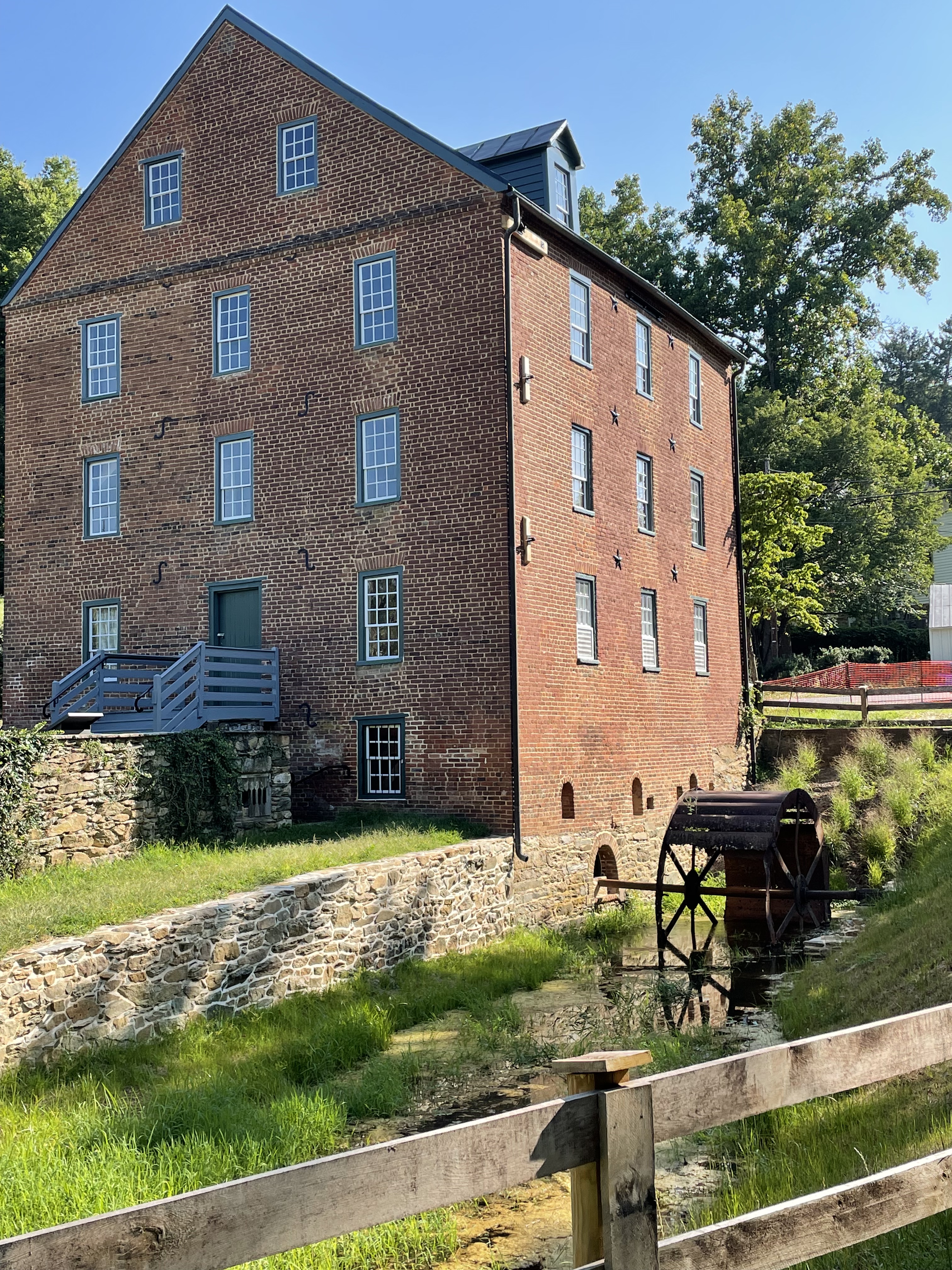
Figure 1. The Waterford mill was constructed in the 1820’s and operated until 1939. It was located along Catoctin Creek because there is a significant drop in stream elevation here. A low ridge behind the mill suggests part of the reason: resistant rocks that produce a series of sudden drops in the stream, perfect for collecting water behind a dam not too far from the mill. The shorter the length of the “head race”, the lower the construction costs. The “tail race” can be seen leading from the waterwheel. This small ditch leads around the facility and drains into Catoctin Creek a couple hundred yards downstream. This post will explore upstream on Catoctin Creek, as far as the mill pond (storage pond for hydraulic pressure), and see what the rocks tell us.

Figure 2. (A) Regional map of the study area. My house is labeled with a star. Bull Run fault is a continuous normal fault that we saw at Morven Park and Banshee Reeks Nature Preserve; its location in the figure is approximate. It demarcates younger Mesozoic rocks to the east from older, Precambrian, rocks to the west; the latter form an elongate ridge that cuts through the study area (rectangle centered on Waterford), as well as the Blue Ridge further west, which front the Shenandoah Valley. Vertical movement along Bull Run fault began about 220 Ma (Ma is a million years, but measured by radiometric techniques) when Pangea was torn apart by the newly forming Atlantic Ocean. (B) Geologic map from RockD of Waterford area. The section of Catoctin Creek discussed in this post is enclosed by a blue ellipse. Note that the Precambrian rocks fall into two distinct sequences: 1.6 Ga (billion years measured with radioisotopes) and gneiss, both metamorphosed; and 1 Ga to 600 Ma volcanics and associated sedimentary rocks. The contact between them is an unconformity but the type cannot be determined from field data. This might be a buried and disrupted late Precambrian (~600 my) thrust fault that pushed older rocks over younger, like we saw at Bull Run Nature Preserve.

Figure 3. (A) View looking downstream along Catoctin Creek, showing rounded cobbles (~2 inches) in a sandy matrix, with silt and mud. This unlikely assortment of sediment grain sizes suggests to me that there are multiple sources being mixed along the creek; for example, rounded cobbles suggest miles of transport along swift-flowing creeks whereas mud is the product of physical and chemical weathering of rocks with a small quartz content (quartz is very hard and chemically stable; i.e. sandy beaches). (B) Exposure of older Precambrian schist along the creek bed, forming a low obstruction. (C) The schist layers (schist is a fissile rock) present a weathered appearance; chemical weathering produces mud in-situ without bedload transport, producing few cobbles.

Figure 4. Examples of different rock types found along Catoctin Creek. (A) Collection of angular schist boulders (~one foot in size) at one of the tributaries to the main stream. (B) Quartz intrusion, probably from the oldest rocks (metamorphosed granites and gneisses). The sample is about one foot long. (C) Fresh surface of the schist, showing fissility and a sheen associated with lower-grade metamorphosis, such as in phyllite. This sample was several feet long and had been transported to the mill-pond dam during construction of the mill.
Figure 5. The dam constructed to retain water for Waterford mill contains a variety of large boulders, but the majority were schist (see Fig. 4C). I didn’t see any granite or gneiss, which isn’t surprising because these large stones would have been difficult to transport in the early nineteenth century. They used what was readily available; the exposure of schist along the creek bed (Fig. 3A) suggests that the ridge fronting the mill (Fig. 1) was a likely source of material; after all, rock had to be removed to build the mill and the town of Waterford.
SUMMARY.
More than 1.5 billion years ago, something was happening in Loudon County, Virginia, long before there were multicellular organisms (eukaryotes) or even land plants. There was a collision of tectonic plates massive enough to produce granite and gneiss (high-grade metamorphism) and then deform these very durable rocks.
Four-hundred-million years later, an episode of extreme volcanism occurred and thick sequences of basalt and volcaniclastic sediments were laid down in Loudon County at about the same time (give or take a hundred million years) as deeply buried shales were being transformed into schist at several locations along the eastern margin of modern North America: less than 50 miles from Waterford, at Great Falls; what would become New York City; and Vermont. This was the closing of Iapetus, which took hundreds of millions of years and stretched for thousands of miles, creating Pangea and the rise of eukaryotes, fish, amphibians, reptiles, and mammals, not to mention land plants.
About two-hundred-million years ago, Pangea was torn apart and grabens formed, filling with sediment eroded from the surrounding elevated terrain. These sedimentary rocks are found east of Bull Run fault (Fig. 2A) where they remained protected from the elements (chemical and physical weathering) while the older rocks were elevated to form mountain peaks in the modern world and eroded into boulders, sand, and mud.
Two-hundred-million years later, the shattered remnants of a once-majestic mountain range, stretching from Canada to the Gulf of Mexico, comprise its core of metamorphic and igneous rocks recording events we can only speculate about today.
3 responses to “Catoctin Creek: Deep into the Precambrian”
Trackbacks / Pingbacks
- - August 29, 2023
- - September 26, 2023

Very interesting brother! What do you know about the magnetic poles changing? Geologic impact?
LikeLike