Figure 1. The study area at the SE tip of Oahu (beneath arrow in inset map) is indicated by the white ellipse. Note the sharp topographic scarp indicated by red shading in the inset; this is the SW rim of the Ko’olau volcano, which split in two. Hanauma Bay and Koko Crater are dormant tuff cones, where ash and some lava erupted as part of the larger Ko’olau volcano. They were active sometime between ~200 and 50 Ky (thousand years).
This was a great opportunity to examine geologically recent (less than 1 my old), large-scale volcanism up close. I’ve seen small cinder cones in northern Arizona that are part of the San Francisco volcanic field, but they were small enough to be surmounted in a couple of minutes; other volcanoes I have seen were either huge (entire mountains) or so old that they were unrecognizable. Koko Crater is a perfect fit. It is 1200 feet high and young enough to preserve a range of volcaniclastic textures, yet easily accessible from a safe parking area.
Figure 2. Summary of volcanism on Oahu. Koko Crater is indicated by the black circle in panel C; it was created during the rejuvenation stage of the Ko’olau volcano (outlined in green in plate A). We visited the central caldera of this massive complex in a previous post, and we’ll see it again later.
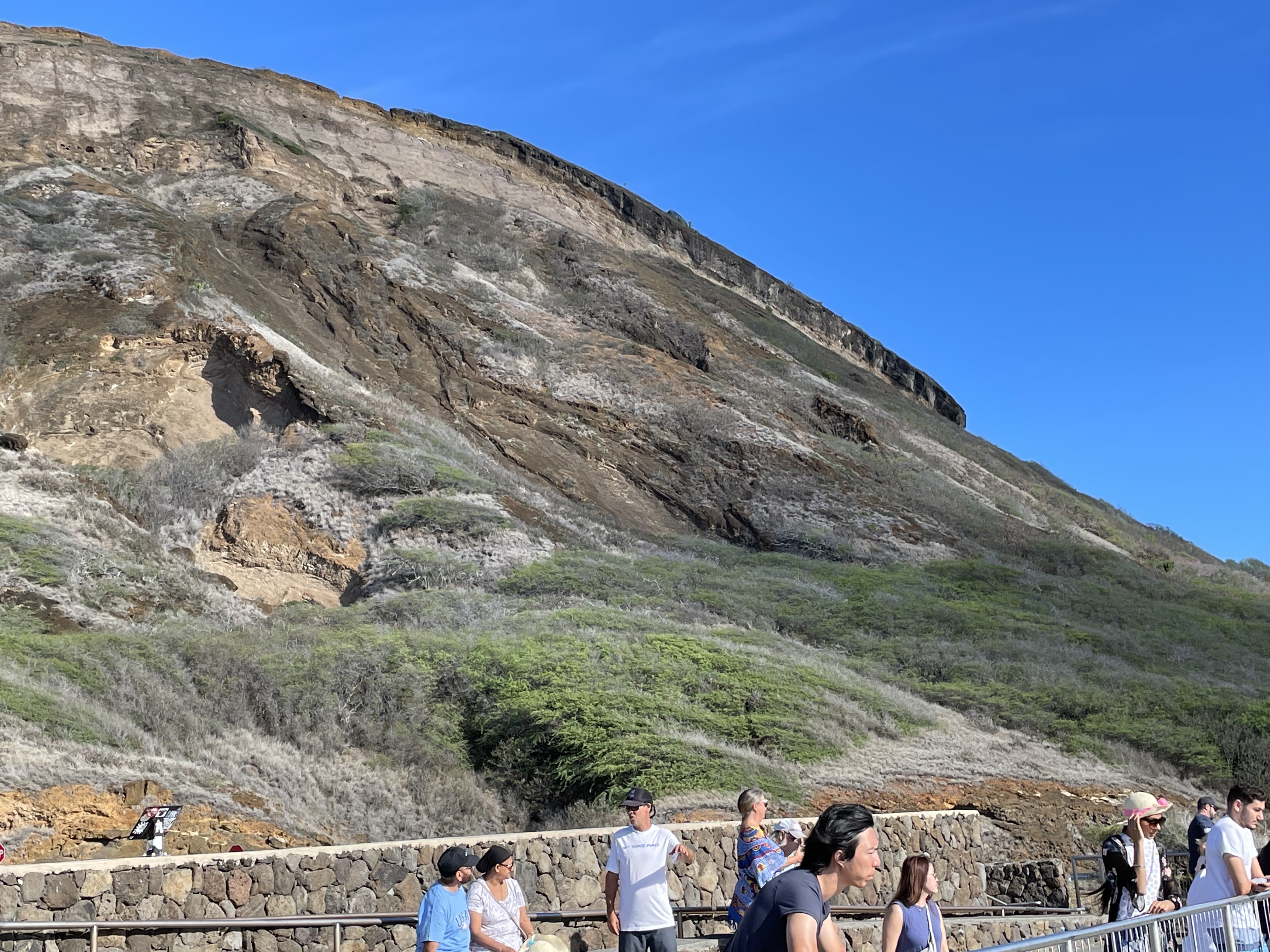
Figure 3. Photo looking north at the base of Koko crater (see Fig. 1). The ash, tephra, and some lava met the Pacific Ocean here and formed a lunar landscape consisting of wave cut platforms (flat areas in mid-image), boulders of every size, and sediment ranging from sand to clay.
Figure 4. View looking NW, showing the steep slope of the cone, capped with what looks like a lava flow. Note the tumultuous appearance of the exposed rock in the middle of the photo. Ash and lava (all volcaniclastic sediments) fill low spots, like streams and valleys, before forming flat layers. This results in a chaotic assemblage of intercalated ash, large chunks of lava, and lava flows.
Figure 5. This photo shows horizontally layered ash beds to the left, truncated by what may have been a valley, that filled with younger ash which weathered much faster (the reddish appearance is caused by the oxidation of iron). Another factor is the cumulative effect of water running down any channel, enlarging it and focusing its powerful chemical impacts. Every fracture or weak point in the tephra layers would have been taken advantage of by water, the best acid nature ever invented.
Field Relations
Figures 3 through 5 show us the lay of the land, but we have to get a bigger picture to understand what we’re looking at; and that is difficult in such an immense landscape. I will try.
Figure 6. View towards the west at the base of the Koko Crater (see Fig. 1 for location). The capping lava? flow seen in Fig. 4 is visible in the upper left; note the steep slop upon which it erupted. The scale of this image is shown by the people circled in blue. The lines, labeled “1”, “2”, and “3” are representative of structural trends (i.e. strike and dip) seen in the volcanic layers comprising the tuff cone.
Structural Trend 1 appears to be close to its original orientation because it conforms to the steep sides of the crater. This alignment is seen on other “ribs” projecting from the crater’s rim. Ash at a temperature of 800 to 1500 F would have stuck wherever it landed and formed horizontally uniform laminae (less than 1/16 inch) and thin beds. This was primary depositional orientation of the ash layers. Of course, ash will fall into steep valleys and fill low spots, just like snow, which is also sticky.
Trend 2 cuts across Structure 1 at more than 30 degrees, but it appears to be local .
Trend 3 dips about 20 degrees towards the crater but its primary orientation is towards the canyon bisected by other ridges seen in Fig. 6. This is a post-eruption feature, as is Trend 2, both of them created as thick layers of ash consolidated, settling more in preexisting valleys than hills. My interpretation is that the valley cutting across (left to right) in Fig. 6 was the edge of the crater when Koko was active. Tephra and basalt collected there to form a plateau (indicated by white ellipse in Fig. 1), which was subsequently eroded, before a few tendrils of basalt flowed out of the crater (e.g. upper parts of Figs. 4 and 6), forming resistant ridges. This post will focus on the stratigraphy of one of these ridges.
Figure 7. Speculative structural analysis of a ridge ~200 yards west of the study area (purple ellipse in Fig. 6). The steeply dipping unit (indicated by “3?”) assumed to be the same as Structural Trend 3 (Fig. 6). If this bedding plane was originally similar to Trend 3 (dotted line), then there is a fault (indicated by the black, dashed line) with unknown slip. The cyan line delineates the estimated base of an hypothesized stratigraphic unit (labeled “4…5?”). Note that the structural trends labeled in Fig. 6 are not identical with their use in this figure, because specific volcanic beds are identified here. In other words, beds “3” and “3?” are assumed to be the same, which suggests that the seaward extension of this ridge dropped almost 100 feet seaward and rotated as much as 45 degrees. Layer “4…5?” is younger because it appears to cover Layers “3” and “3?” equally while not being disturbed.
Figure 7 reveals at least two unconformities; the fault that dropped the seaward block down a few feet as it rotated, and what appears to be an erosional surface (the cyan line delineating layer “4…5?”). The complex pattern of episodic eruption, erosion, and deformation on the eastern margin of Koko crater is not unusual for a monogenetic volcanic cone, which remains active for a short while, until the magma chamber decompresses (so to speak).
Volcaniclastic Examples
It is time to speak to the rocks, hear their side of the story, and listen to them if we can. All wisdom comes from the earth, and thus it behooves us to hear with our eyes and our imagination (rocks don’t talk), the story that has been written in … stone.
Figure 8. A volcanic bomb (~1 foot across) depressing preexisting layers of ash. Considering the weight of the class, the ash must have been partly consolidated when the bomb struck. Note that the ash layers may represent multiple eruptions over a period of days to years.
Figure 9. Resistant ash layer forming the ridge seen in Fig. 6, containing irregular pieces of vesicular and massive basalt contained in a matrix of ash, which weathers to a rust color. These clasts are actually cemented to the ash, similar to the relationship seen in Fig. 8. Note the layering of the ash at the lower-right part of the image.
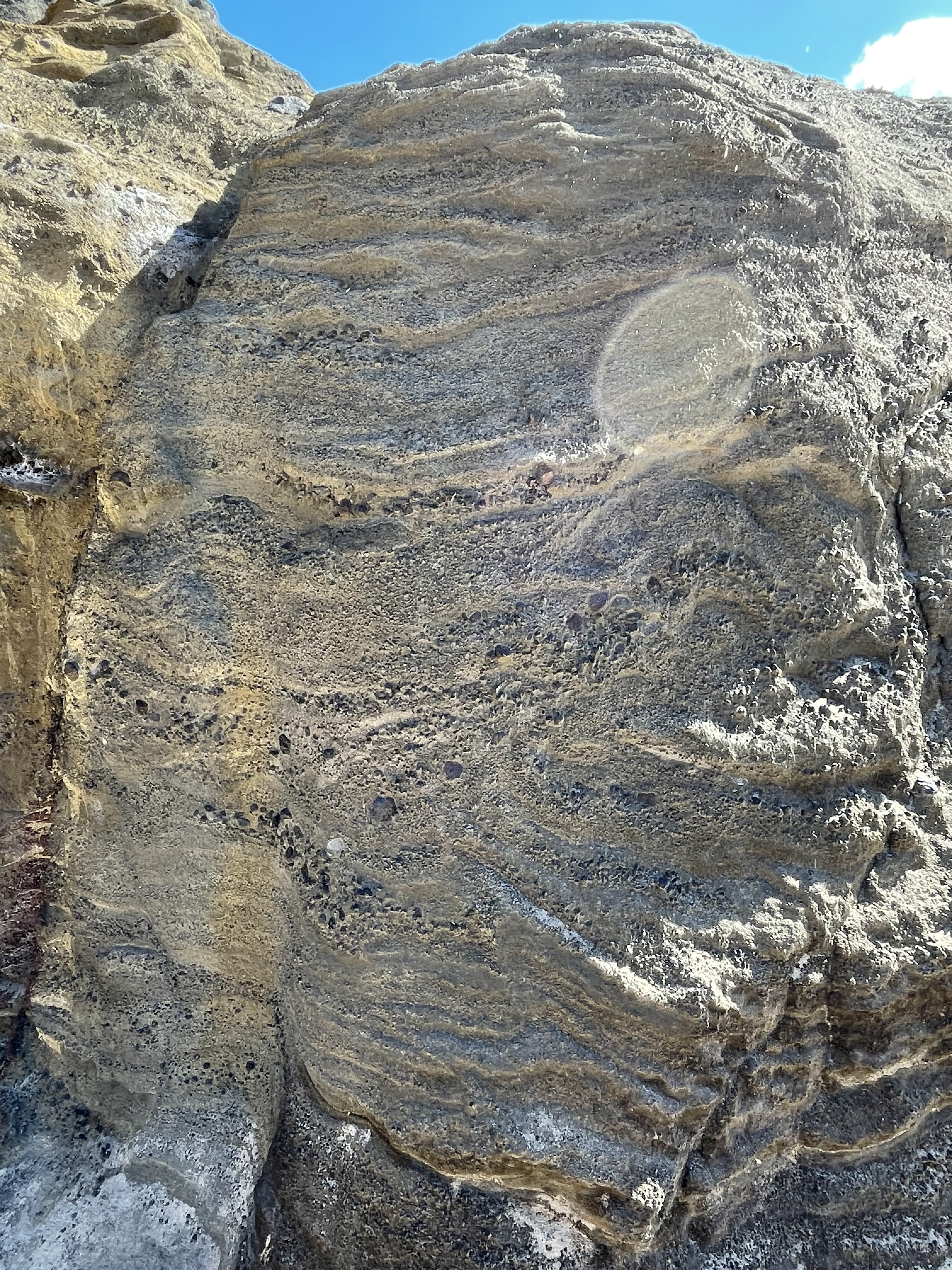
Figure 10. Irregular basalt clast in an ash matrix. There are two interesting features of this photo: (1) the bomb is highly irregular, as if it was blown out of the vent, ripped from older volcanics; and (2) the circular line around the object is the projection in map view (horizontal) of the depression seen in cross-section in Fig. 8. When these objects hit sticky ash, they form hemispherical depressions that look like bowls.
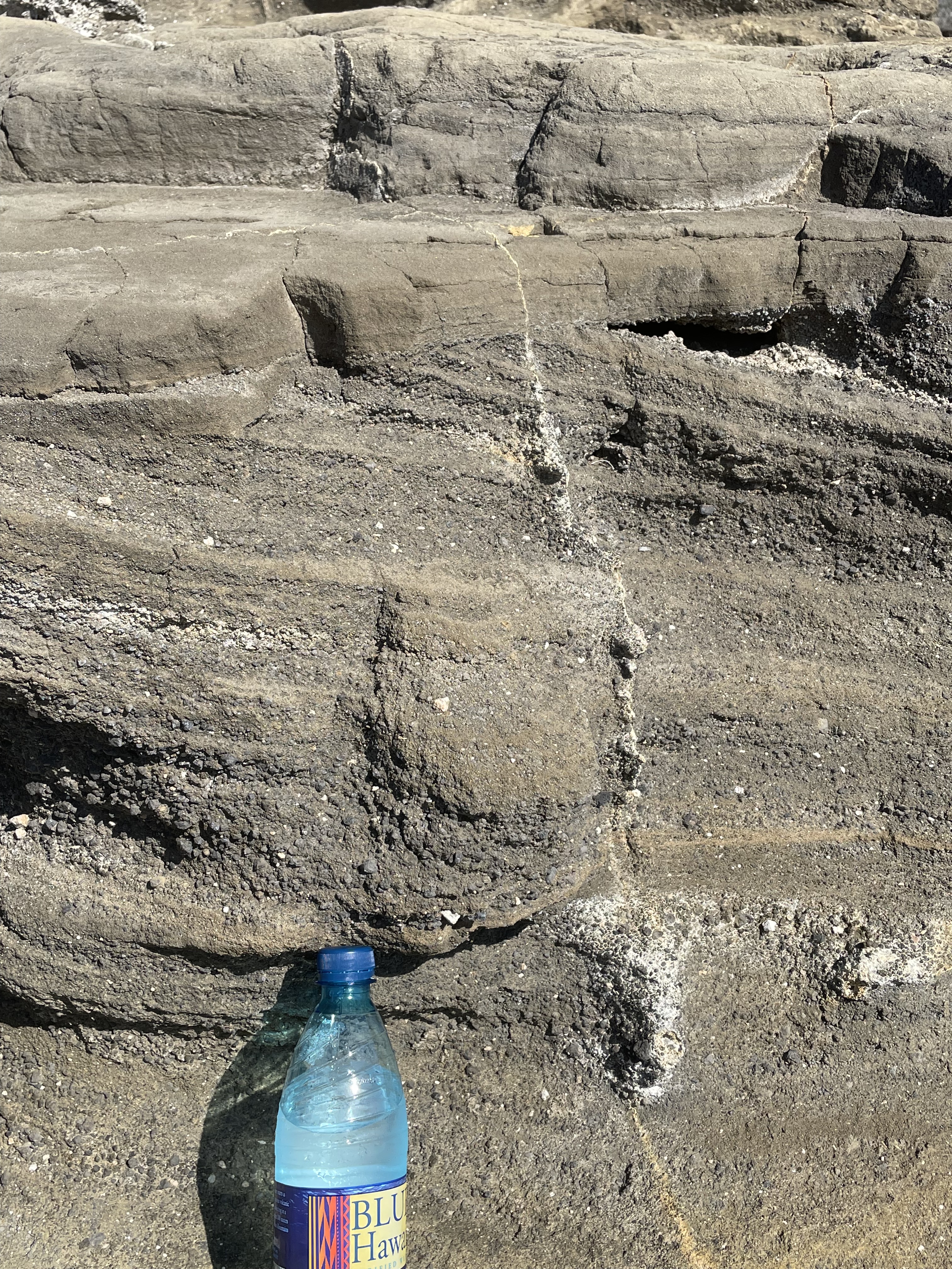
Figure 11. Vesicular basalt bomb in ash matrix. Note the rounded form, which suggests transport some distance by water. The bomb next to it is not vesicular and it is less rounded, even though exposed to the same weathering forces since exposure in the ash flow. (Believe it or not, these two boulders are absolutely stuck to the muddy looking rock below them.)
Figure 12. Large boulder (~3 feet across) of volcanic diamictite containing gravel and small boulder-sized particles. Even the ones that look like they’re lying on the boulder are stuck hard (they have been exposed to ocean waves for millennia).
Sedimentary Examples
Figures 8 through 12 unambiguously show that volcanic tephra of every size and shape were thrown into the air and landed in hot and sticky ash, where these bombs became clasts, forming volcaniclastic rocks. Now we will look at some examples of rocks that are just as hard, but that reveal sediment transport by wave action.
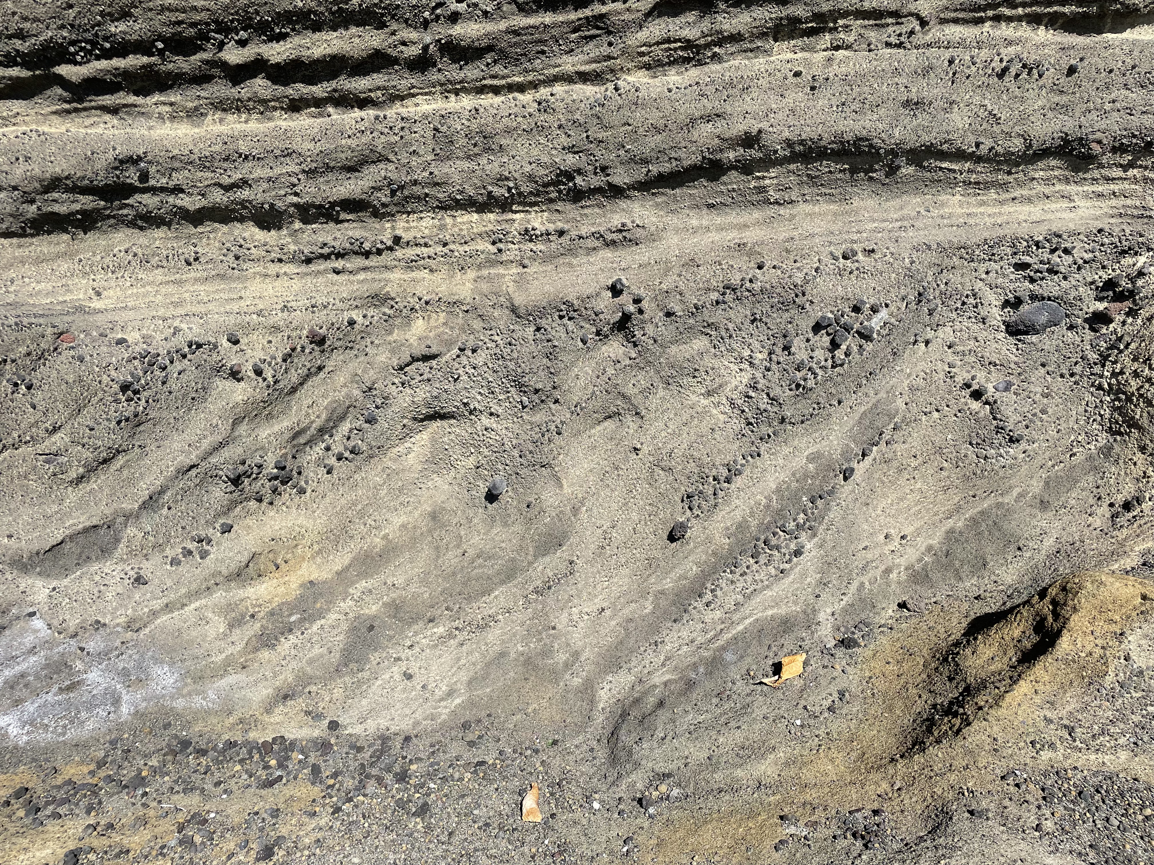
Figure 13. Photo of cross-bedded layer from within the purple ellipse in Fig. 6. Note the coarse layer tilted to the right just above the water bottle, which also indicates a convex-down depression in the subjacent layer, suggesting erosion by running water. The cross-bedding is unidirectional, which suggests reworking of tephra and ash by waves, like in Fig. 3. The overlying layer shows no sign of disturbance, the ash laminae being horizontal.
Figure 14. In-place volcaniclastic rock at current sea level, showing overlapping coarse and fine layers similar to what is seen in the swash zone of any beach with such different sediments available. The large voids are probably caused by dissolution of carbonate minerals that formed during shallow burial (less than a hundred of feet of lava and ash), rather than vesicular lava. The image is approximately 6 feet across.
Figure 15. Layer of unidirectional cross-bedded layer, approximately 18 inches thick. Gravel collected on the slip face of sand waves near the beach, scattered among sand-sized particles. The wave direction would have been to the right (approximately NE), very similar to today’s environment.
Summary
I’ve presented a lot of data on volcaniclastic rocks at Koko Crater. Before I summarize I’d like to present one last annotated photo, which shows the stratigraphy as well as I can tell from my limited access to good cross-sections (aka road cuts).
Figure 16. View looking downdip, showing the approximate stratigraphy of the rocks exposed within the purple ellipse in Fig. 6. Ash collected, without being disturbed, in the oldest part of the section, and was replaced by basalt with features that suggest eruption beneath the ocean, usually pretty deep, but shallow-water occurrence has been observed. A sequence of ash then collected quietly (Ash Laminae) before being replaced by grains of lava and other rock fragments (Ash/Sand/Gravel), culminating in Cross-bedded Ash and gravel (see Fig. 13). I would estimate the thickness in this figure to be about 30 feet, which would have taken thousands of years to collect, because of the implied change in water depth. Of course, the “Pillow” structure may be misinterpreted, which would change the estimate considerably.
I would like to add a few points to Fig. 16. First, older sediments were seen at the current beach (Figs. 14 and 15) which clearly indicate a surf zone environment. These rocks may be from as much as 100 feet down-section (older), which is consistent with changing relative sea level caused by global sea level fluctuations during the last 100 Ky, and uplift and settling of the Koko crater itself, as magma pushed up and relaxed.
Rocks from~50 feet further up section (younger) demonstrate that the ash was deposited at or slightly above sea level (Figs. 8-12). The total section has a thickness of approximately 100 feet (guesstimate not based on careful measurements, but eyeballed), which must have been deposited within a few thousand years because of the young age of Koko Crater (~50 Ky).
Finally, Koko crater is a tuff cone, which means that it mostly created hot ash as a magma chamber locally depressurized. This kind of eruption doesn’t reoccur once pressure has dropped below the strength of the overlying rocks. Tuff cones are part of larger volcanoes, in this case the Ko’olau volcano, one of three that created Oahu and dominated volcanism for the last four-million years (Fig. 2).
One last word–I have never seen photographs like those I took for this post, not in a text book, Wikipedia, or anywhere else. I don’t know why that is, maybe academic geologists are too busy teaching geology to stop and smell the roses…


Trackbacks / Pingbacks