A Geological Mystery at Bears Den

Figure 1. View of the Shenandoah Valley, looking west from a crest of the Blue Ridge Mountains.

Beautiful landscapes and geological wonders are never far from your door here in Northern Virginia. Today, we took a hike to meet the Appalachian Trail near the border of West Virginia (Fig. 2).

Figure 2. Geologic maps of the study area, located NE of Washington DC (see small inset map), about 30 miles west of Sterling. We climbed about 1000 feet along Route 7 (purple line crossing E to W above the small inset map), crossing a Proterozoic metamorphic terrane represented in shades of purple and gray. The northern part of this zone is a light-colored (leucocratic) granite that has been metamorphosed whereas the southern part comprises a granitic gneiss. These batholithic intrusions are crosscut by a spectrum of metamorphosed granitic rocks known as Charnockite (orange lines). West of this area of Grenville intrusives, we crossed metabasalts of a somewhat younger age (green zone in map), the Catoctin Formation, which we saw in an earlier post. The leftmost inset map extends the large USGS map of Loudon county because the field area was just outside its domain. The oval indicates the area discussed in this report.

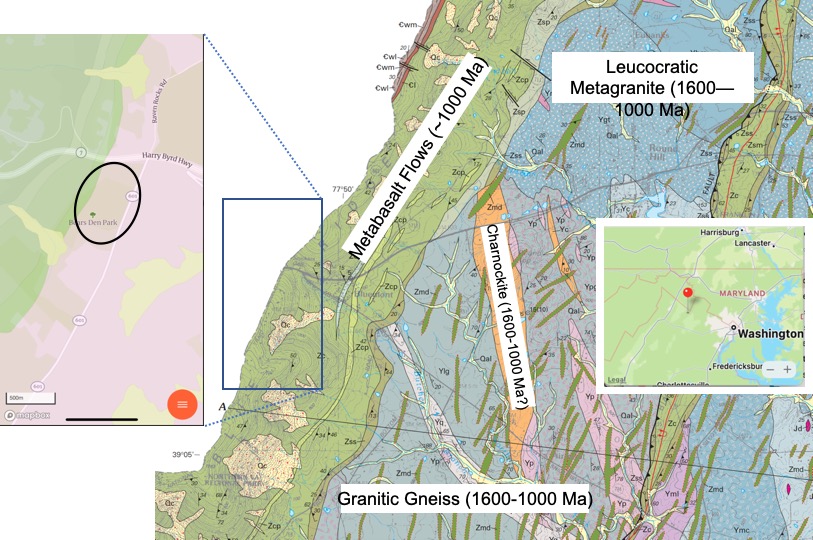
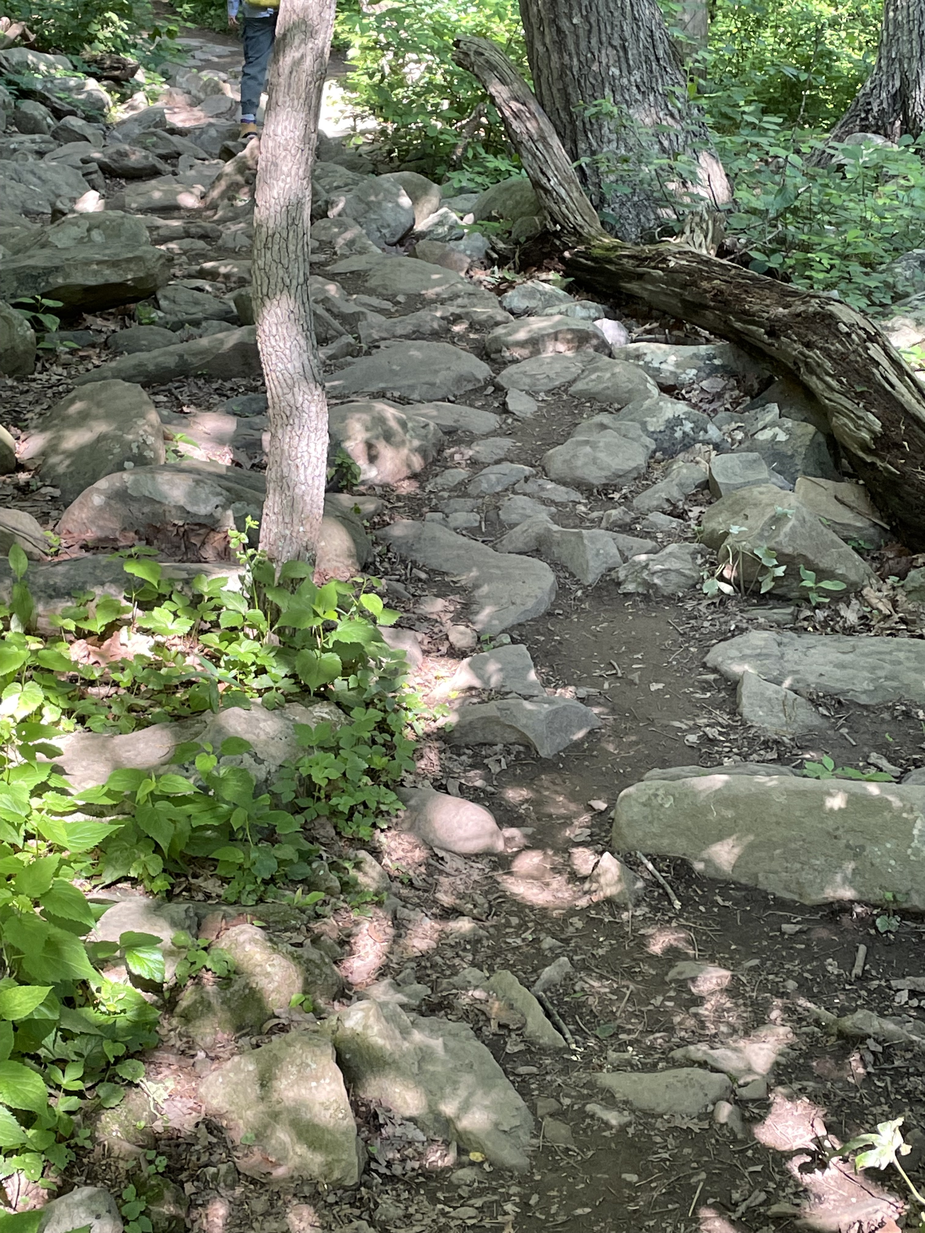
To reach the Bears Den rest area on the Appalachian Trail (see oval area in Fig. 2), we had to follow a winding path along one of the many irregular crests that define the Blue Ridge Mountains (Fig. 3).

Figure 3. Trail head for the short hike to Bears Den.

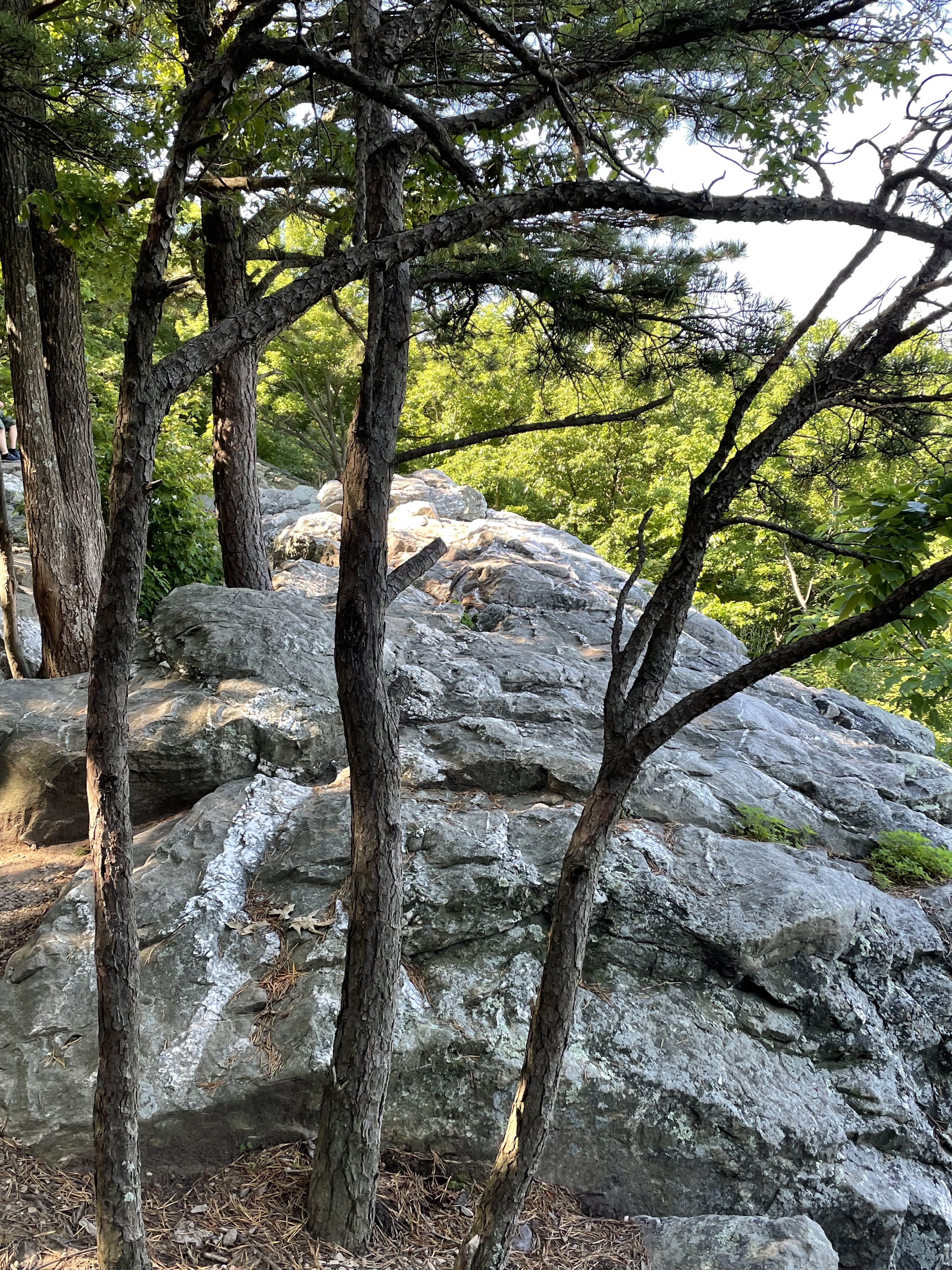
Along the way, we noted that the trail followed the top of a deeply eroded landscape, littered with boulders and weathered rocks (Figs. 4 and 5).

Figure 4. The path from the parking lot along Route 7 to meet the Appalachian Trail (see Fig. 2) was littered with boulders like these.
Figure 5. Large boulder dissected by a weathered joint. This was a local topographic high. This rock had faint lineations oriented nearly vertical that can be seen in the photo. However, as large as it is, this boulder may have rolled from an outcrop.

We finally reached the rocky point from which Fig. 1 was photographed. A large outcrop crosscut with veins greeted us (Figs. 6-8).

Figure 6. Top of the outcrop of (thus far) unidentified rock holding up the Blue Ridge Mountains. Note the white layer visible in the lower-left part of the photo.
Figure 7. Photo of the top of the outcrop in Fig. 6, showing joint sets filled with a light-colored mineral (either quartz or feldspar). The veins are standing out because the host rock has weathered, suggesting that they are quartz, which is very resistant to chemical weathering.
Figure 8. Close-up of thin, intersecting joints, but at a much lower angle than those seen in Fig. 7.

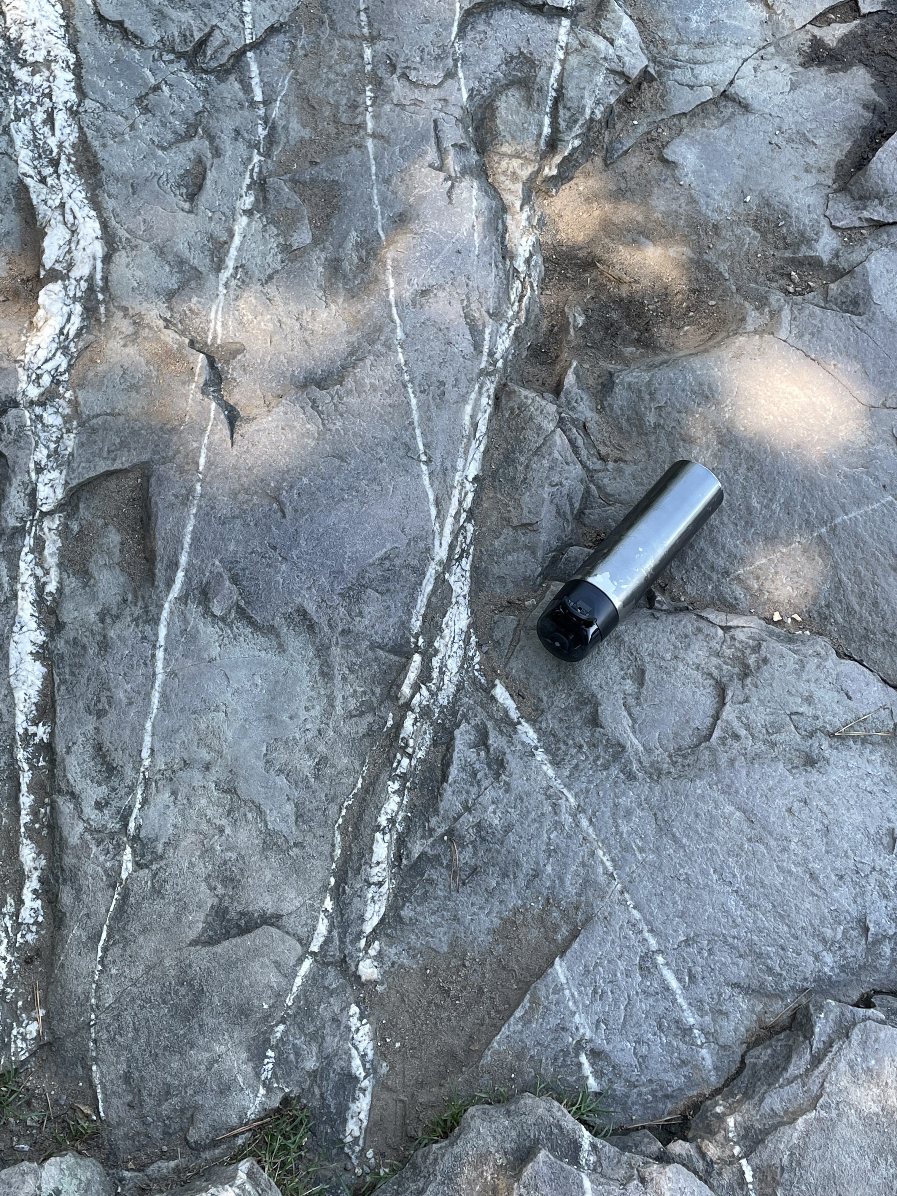
Intersecting joints like those seen in Figs. 7 and 8 occur when rocks that have been deeply buried are exhumed as overlying rocks erode. The upper mantle relaxes and lifts its overburden in a process called isostatic rebound. Rocks thus uplifted are no longer soft but respond like a solid in brittle deformation. What is intriguing about these rocks (whose age we haven’t yet determined) and the joints that permeate them, is the origin of the quartz and feldspar filling the joints.

It’s time to talk about the host rock seen in Figs. 4-8. The west side of the oval outlined in the inset map of Fig. 2 reveals that these are fluvial-to-shoreface sedimentary rocks deposited between 541 and 511 Ma (source: Rock D lists many sources for this interpretation).

Figure 9. Hand sample view of host rock, revealing a sandy texture that has been altered by thermal metamorphism, as indicated by the overall sheen (caused by quartz remineralization). The image is about 6 inches across.
Figure 10. The original sedimentary texture is evident in this photograph, although it has been modified after burial. There is no evidence of permeating ductile deformation (e.g. folding of sedimentary layers).

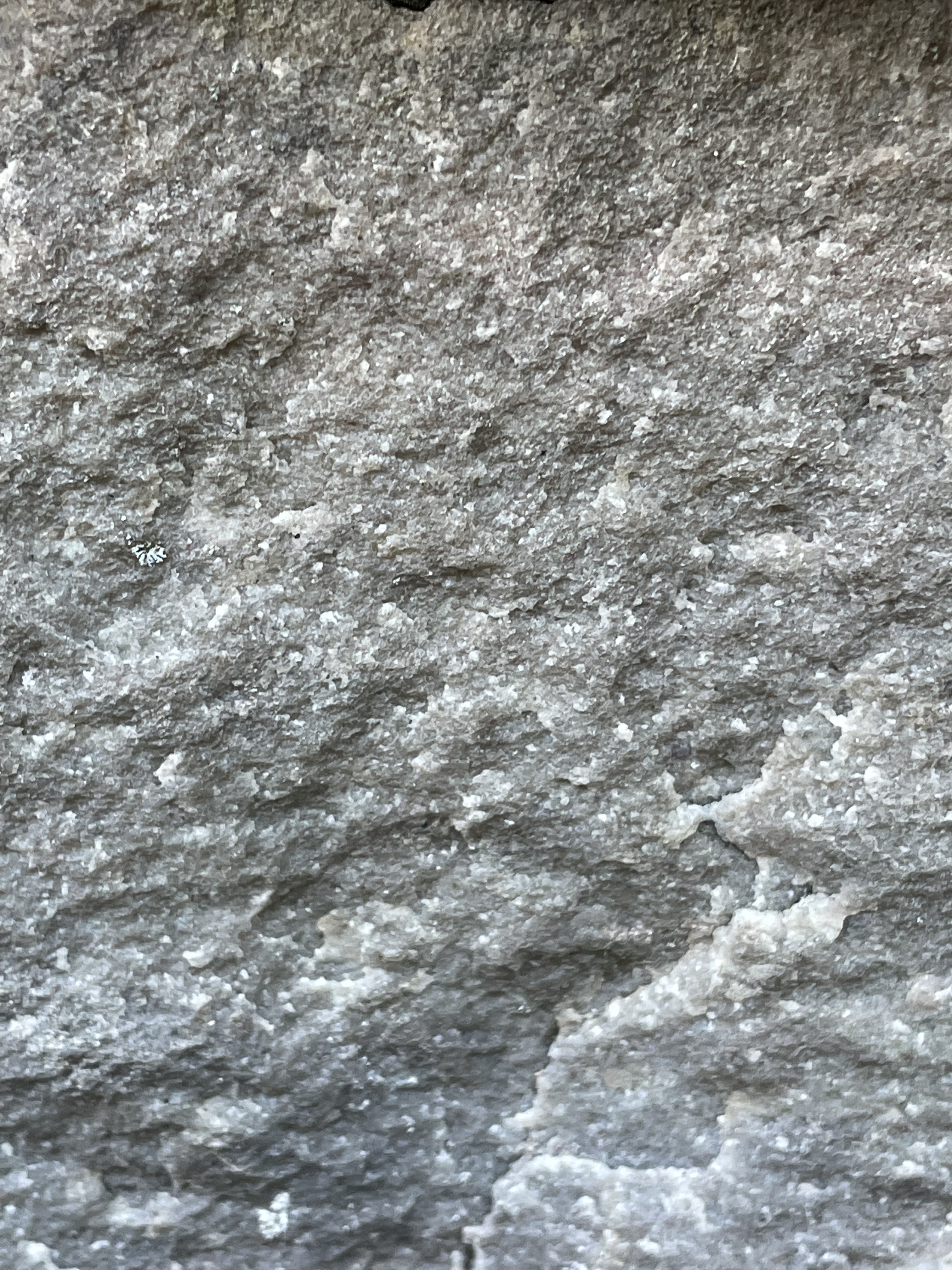
An intrusive magma filled joints (Figs. 7 and 8) and heated the country rock to the point of remineralization (Fig. 9), yet sedimentary textures are retained (Fig. 10). What’s going on?

Figure 11. Close-up (magnification is ~3x) of quartz vein in country rock, revealing a recrystallization aureole as seen in the gray area transitioning into mixed light and darker areas at the top of the image. This is a classic example of contact metamorphism. The host rock (as seen in Fig. 5 for example) wasn’t being deformed. It was actually fracturing (Figs. 7 and 8), when a new intrusion occurred, one not reflected in the Proterozoic granites found within the area (Fig. 2).
Figure 12. Photo (~4x magnification) taken from same exposure as Fig. 11, showing an intrusive texture, which is indicated by undeformed quartz (gray) and feldspar (white) crystals.

Summary

There are some general rules in determining relative geologic age. For example, layered rocks are younger as you ascend in a stack of them. This rule applies to both sedimentary and volcanic rocks, although the contacts aren’t as uniform in the latter. Another rule is that rocks that cut through other rocks (i.e. veins and dikes) are younger than the rocks they invade.

The sedimentary host rocks at Bears Den were deposited where rivers fed coastal deltas and a sandy beach (shore face) about 500 million years ago, long after the granites we see to the east (Fig. 2) were intruded and metamorphosed to become metagranites. In other words, the quartz veins and granitic dikes (Figs. 7-12) did not occur when the older (1600-1000 Ma) igneous rocks were emplaced; these veins and felsic intrusions must be associated with the Taconic orogeny, which started about 440 million years ago. The geologic map (Fig. 2) doesn’t show any evidence of granitic intrusions from this period, which could have filled joints created by isostatic rebound in these rocks.

These sedimentary layers were laid down during the collision that created Pangea, so they would have had to be buried deeply enough to become lithified, exhumed to a sufficiently shallow depth to form joints (a sure sign of brittle failure and thus uplift), then invaded by an undisclosed intrusive magma at a very shallow depth (probably less than 5 miles).

Alternatively, they could have remain buried until the breakup of Pangea, beginning in the Triassic period and progressing in stages. Magmatism has been associated with this event in Northern Virginia.

All of this is plausible, given the immense span of time involved, but…

Where are the rocks?

Leave a Reply

Fill in your details below or click an icon to log in:

WordPress.com Logo

You are commenting using your WordPress.com account. Log Out /  Change )

Twitter picture

You are commenting using your Twitter account. Log Out /  Change )

Facebook photo

You are commenting using your Facebook account. Log Out /  Change )

Connecting to %s

%d bloggers like this: