Several of my posts in Northern Virginia have noted the presence of old canals which were part of the earliest transportation system to reach beyond the Atlantic Seaboard (e.g. The Potowmak Canal and Goose Creek canal). Today we crossed the Potomac River and followed the Chesapeake & Ohio Canal for several miles (between Locks 28 and 29), which took us along a scenic path through a metamorphic terrain in Maryland.
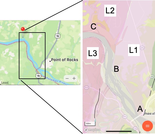
Figure 1. “Point of Rocks” tunnel at US-15 on the Maryland side of the Potomac River. This railroad was built at about the same time as the C&O canal (early 19th century) as they both negotiated this narrow right-of-way between Catoctin Mountain on the right and the Potomac. Note the cut wall of dark rock on the right. See Fig. 2 for location. Figure 2. Map of “Point of Rocks” location on the Potomac River. The inset map shows the geology of the area indicated by the rectangle. Photos were taken at Sites A through C. Key to lithologies: L1 — Catoctin Formation (1000-541 Ma) comprises basalt metamorphosed to green-schist facies, with sedimentary rocks found as lenses, as well as flow bedding, formed from a rifting continent; L2 — Biotite granite gneiss (1600 – 1000 Ma), gray with black streaks; L3 — Pink leuocratic metagranite (1600 – 1000 Ma), gneissic foliation.
The cut for the tunnel (Fig. 1) reveals a dark rock with foliation oriented nearly vertical in the plane of the cut (Fig. 3) with blebs of pink and white material (Fig. 4).
Figure 3. Outcrop (photo is approximately 12 feet in height) of Catoctin Fm., showing irregular foliation based on original basalt bedding. Note the lighter colored area running diagonally from UL to LR, bounded on the LL by a very dark area. This is very likely a remnant of the original volcanic layering (basalt beds are often irregular).Figure 4. Detail from outcrop in Fig. 3, showing a pinkish bleb and lens in the UR quadrant. Note how foliation flows around these zones, which are probably epidosite, a mineral produced by leaching of metals during thermal metamorphism of basalt. This image is about 2 feet across.
These basalts originally flowed out of fissures and volcanoes, probably at the seafloor, during rifting of a continent (according to Rock-D‘s summary). The origin of magma can be correlated to tectonic regime (e.g., mid-ocean ridge, rifting continent, island arc) based on the chemical signature of the whole rock (not minerals, which are altered during metamorphosis). At any rate, the age range of the Catoctin Formation (1000-541 Ma) spans the final closing of an unnamed ocean to form a hypothesized supercontinent called Rodinia during the Grenville Orogeny between 1100 and 900 Ma — and the subsequent rifting of Rodinia, which occurred between 750 and 633 Ma. Unraveling that time discrepancy is beyond the scope of this blog.
Let’s just say that these basalts (and minor sedimentary rocks) were created during the tumultuous assembly, pleasant life, and violent breakup of a hypothesized supercontinent.
Figure 5. Zoomed-in photo of irregular leucrocratic structure (estimated to be ~50 feet long) on a cliff that was more than 100 feet in height. This unusual feature may be a deformed sedimentary lens as mentioned in the Rock D description. It is too large to be analogous to the epidosite inclusion seen in Fig. 4.Figure 6. Image of bedding in Catoctin Fm., seen from several hundred feet through thick foliage. Note the contrast between the dark and light beds. The difference is probably caused by subtle changes in the minerals that were produced during metamorphism, but they reflect original volcanic layering, squeezed and deformed during burial (maybe as deep as 15 miles). It is also noteworthy that large-scale folding is absent.
The Catoctin Formation (basalts with some sediments) were buried deeply and metamorphosed by heat and burial pressure but not compressed, at least not enough to produce folds visible at the scales of Figs. 3 through 6. This suggests that Rodinia wasn’t created by huge horizontal forces, crashing tectonic plates together like putty.
Jumping ahead in time to the present, we see these rocks still controlling the Potomac and the development of transportation during the early days of the United States.
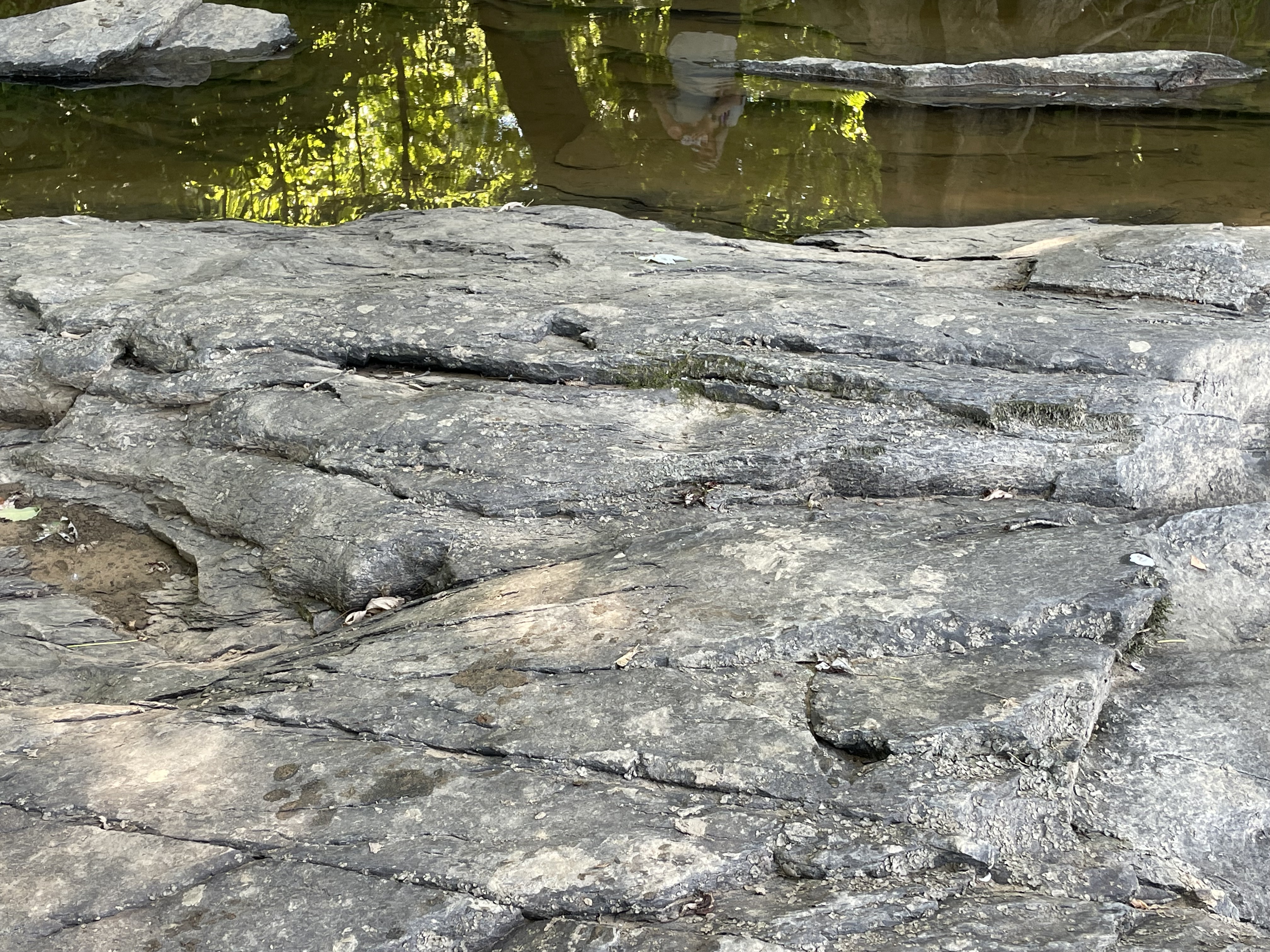
Figure 7. View of the Potomac at Site B (see Fig. 2 for location), looking west towards Virginia. The rocky islands are the emergent parts of the basement rocks.
The outcrops seen in Fig. 7 occur very near the contact between the Catoctin Formation and a Pink leuocratic metagranite (1600 – 1000 Ma) with gneissic foliation (L3 in Fig. 2).
Figure 8. Outcrop of unidentified rock from Fig. 7, showing some sign of weak foliation but no evidence of an other texture or mineralogy, without breaking a piece off (which we don’t do in this blog). The irregular foliation was estimated to have a strike of 31 degrees (NNE) and a dip of 20 degrees ESE.
It is important to note that the outcrop in Fig. 8 has been exposed to the vagaries of the Potomac since the Pleistocene, so its irregular surface is not unexpected. Nevertheless, the estimated orientation is radically different than that of the Catoctin Fm, which is nearly vertical (see Fig. 6). One possibility is the presence of a fault between the two rock formations, as suggested by the geologic map (Fig. 2). The fault (indicated by the nearly vertical, black line south of Site B) may extend under the alluvial sediments around the Potomac and not be visible in Maryland.
Figure 9. Lock 28 of the C&O Canal operated from about 1834 to 1923. It was operated by a lock keeper, who lived with his family in the cottage to the left of the photo. The C&O canal is to the right (filled with debris and old trees) of the now-asphalt tow path, and the railroad now has two tracks to the right of the canal, out of the image.
We have one last stop today, Site C (see Fig. 2 for location), where we will try and get some closure on the fate of Rodinia (pun intended).
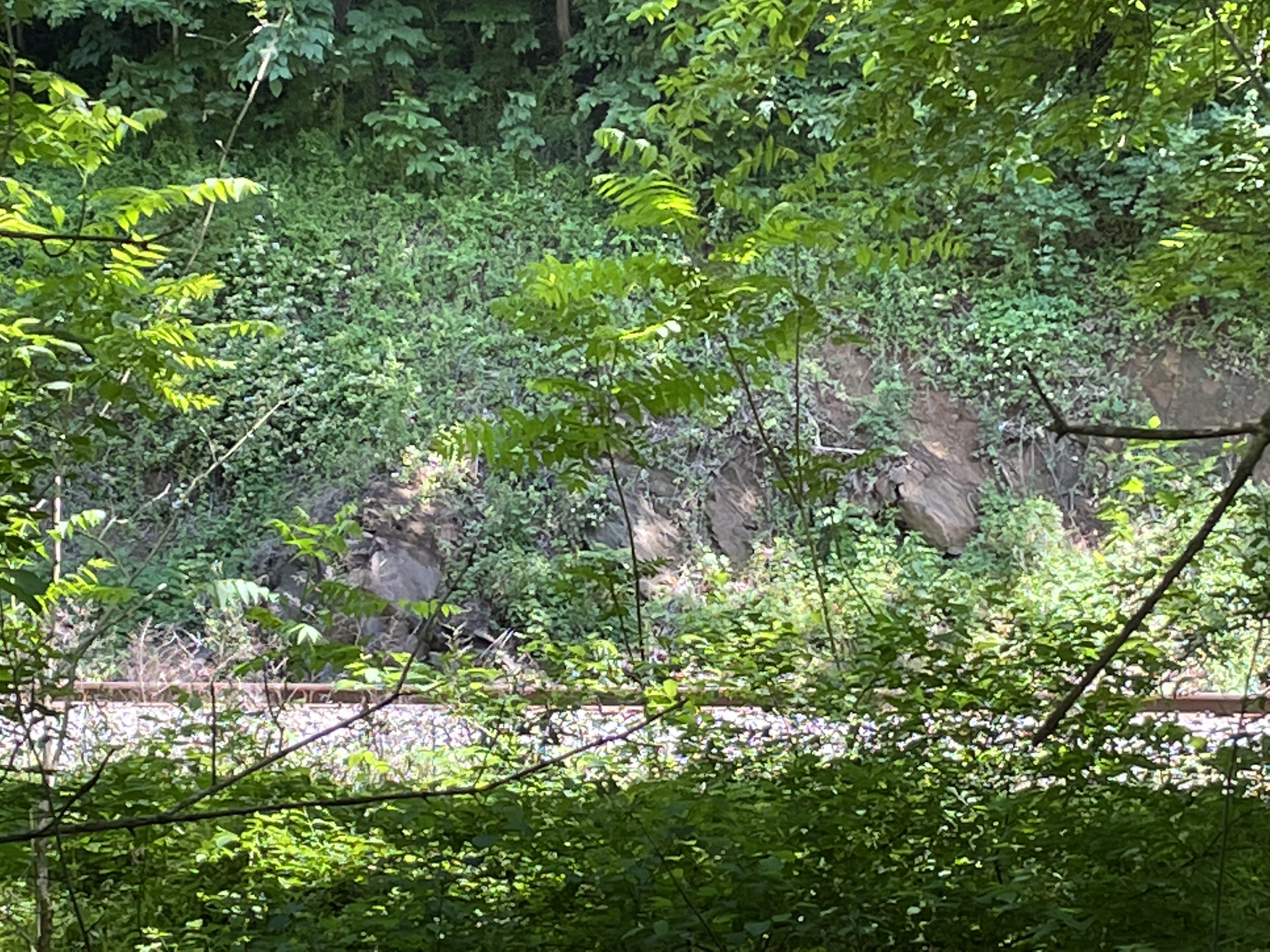
Figure 10. View looking SE along Catoctin Creek towards its confluence with the Potomac River. Figure 11. The C&O Canal aqueduct at Catoctin Creek was one of many such structures, constructed to carry barges over the Potomac’s tributaries. Note the different hue of the blocks comprising this 188-year-old structure; the left abutment is original, constructed of pink granite (lithology L3 in Fig. 2), whereas the central span was rebuilt in the 1970s of a granite gneiss (lithology L2), after it collapsed.Figure 12. View of outcrop along the B&O RR line that runs parallel to the C&O canal. The poorly exposed, and partly hidden by foliage, rocks we see are, according to the geologic map (Fig. 2), a biotite granite gneiss. About the only thing I can say about them from this distance is that they appear to have a foliation that is dipping steeply to the east (right in the photo).
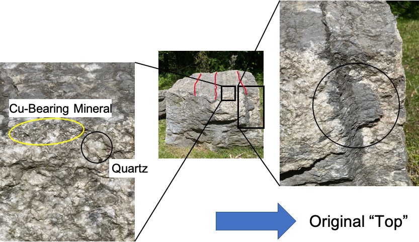
Let’s take a look at some samples that were conveniently made available by the Maryland DOT, probably during construction of the park.
Figure 13. Large block (about 3 feet across) of biotite granite gneiss (lithology L2 from Fig. 2). Note that the large phenocryst in the inset (~2 inches across) has not rotated during deformation but, instead the foliation has deformed around it. Figure14. Block of gneiss showing intrusive contacts. The red lines on the central photo indicate some kind of layering, which could be from burial of sediments or extreme burial stress on an igneous rock. There is no evidence of folding, not even at smaller scales. The right close-up shows a dark layer interacting with a pinkish intrusion. It is being drawn into the intrusive material and melting, losing its identity so to speak. Note how the thin black layer (top of right photo) has stretched right-to-left in the circled area. The left close-up shows minerals with no foliation in the intrusive (younger) rock, which was certainly in a molten form at the time. Note the presence of Cu-bearing minerals (shiny and metallic), which grew from metals drawn out of the host rock.
The rocks we saw today were of similar ages (determined by radiometric dating, not guesswork), and were deposited, deformed, and intruded during the Grenville Orogeny. In other words, based on my brief examination of the literature, these rocks represent the collision of continents to form Rodinia (1100-900 Ma), its long lifespan (900-750 Ma), and its breakup to form the precursor of the Modern Atlantic Ocean (Iapetus) between 750 and 633 Ma.
I’m going out on a limb here (again). It is significant that there aren’t a lot of sedimentary rocks (even metasediments) here, which means they were removed by erosion. Keep that in mind, when I add that even the oldest metamorphic rocks (the granite gneiss, L2) aren’t folded like the schists at Great Falls. These rocks were buried deeply, relative to the impact they survived, which apparently didn’t affect the deeper parts of the crust (at least not along the modern Potomac River). There probably was a lot of folding of the sedimentary rocks that covered these igneous and metamorphic rocks, but they were eroded away during the 150 million years that Rodinia was a (quasi) stable supercontinent. That’s a long time. The youngest of the Catoctin rocks (~540 Ma) were deposited just as the so-called Taconic Orogeny was starting up in modern-day New England…
It is extremely difficult to wrap our minds around such four-dimensional events playing out on such long time scales but, to make it even more fun, the mantle and core are dancing to their own tune and directly influencing everything we experience and can observe from our perilous seat atop the earth’s crust.
Just look at all those canals we dug to avoid the rocks…


Trackbacks / Pingbacks