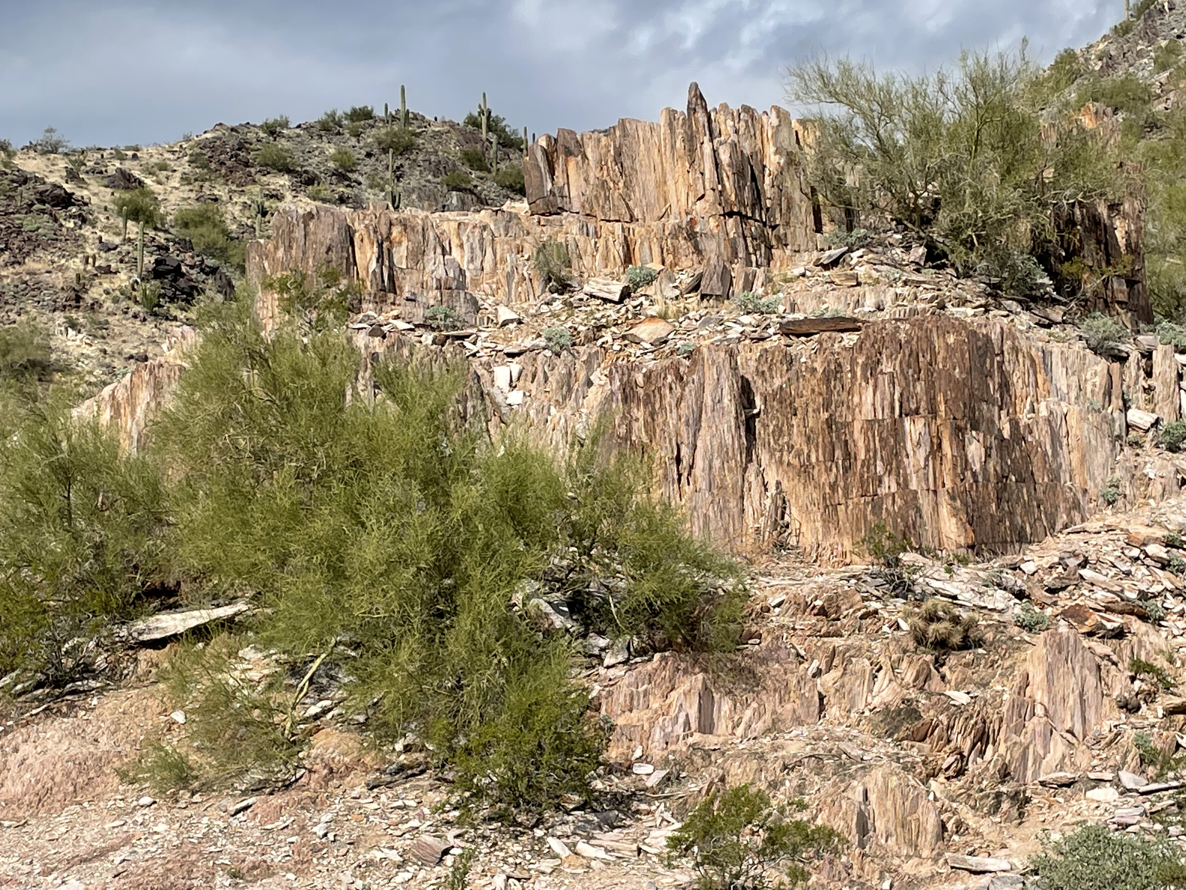
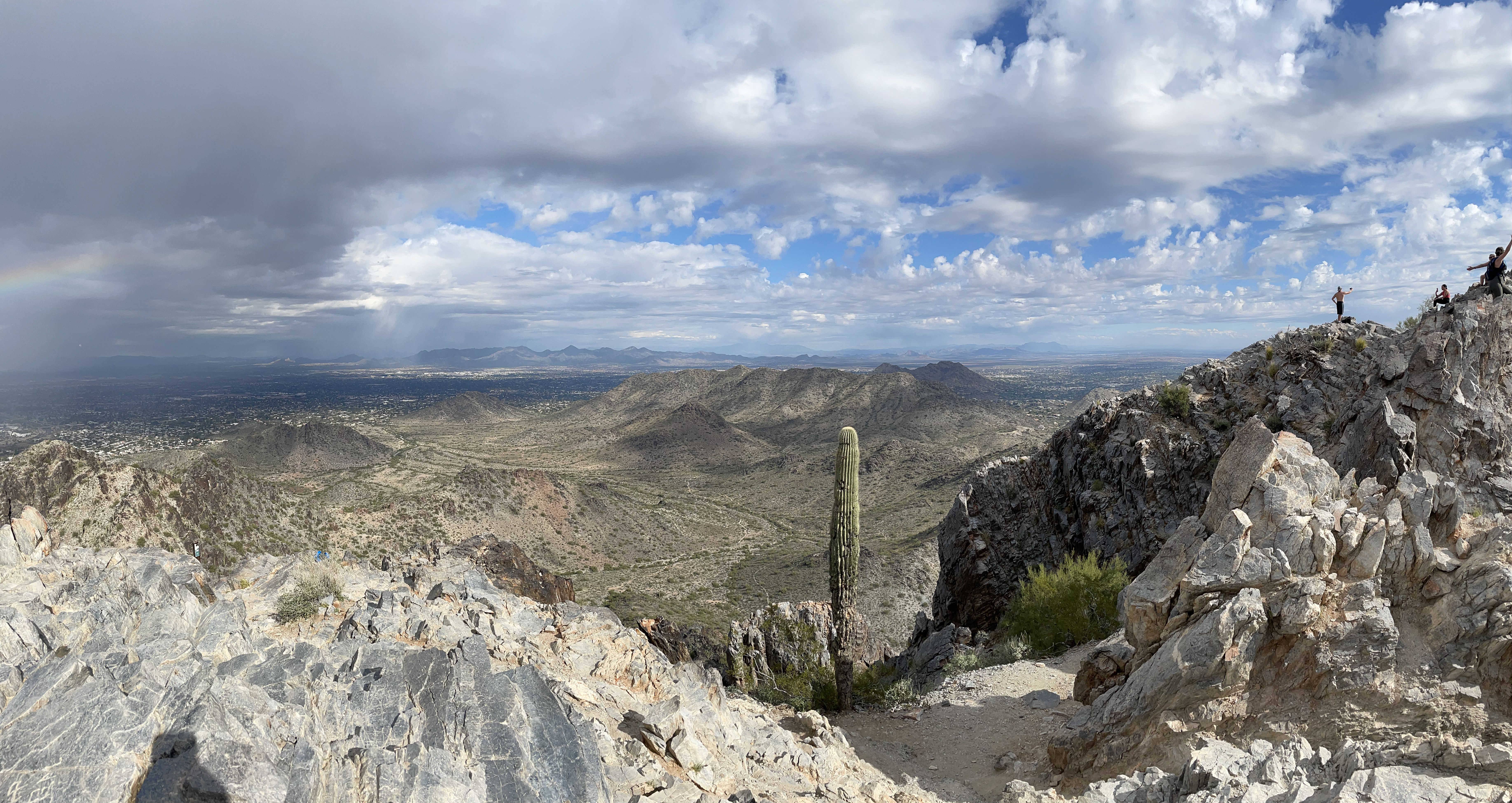
Figure 1. View of Piestewa Peak, the highest point of the Phoenix Mountains, from the parking lot. The top is about 1200 feet higher in elevation than where the photo was taken.
My last post examined some structures and petrology of a Metamorphic Core Complex (MCC), whereas the previous one discussed the geology of the Central Highlands of Arizona. I mentioned several times that these geologic provinces were but two manifestations of the profound tectonic change associated with uplift of the the Colorado Plateau.
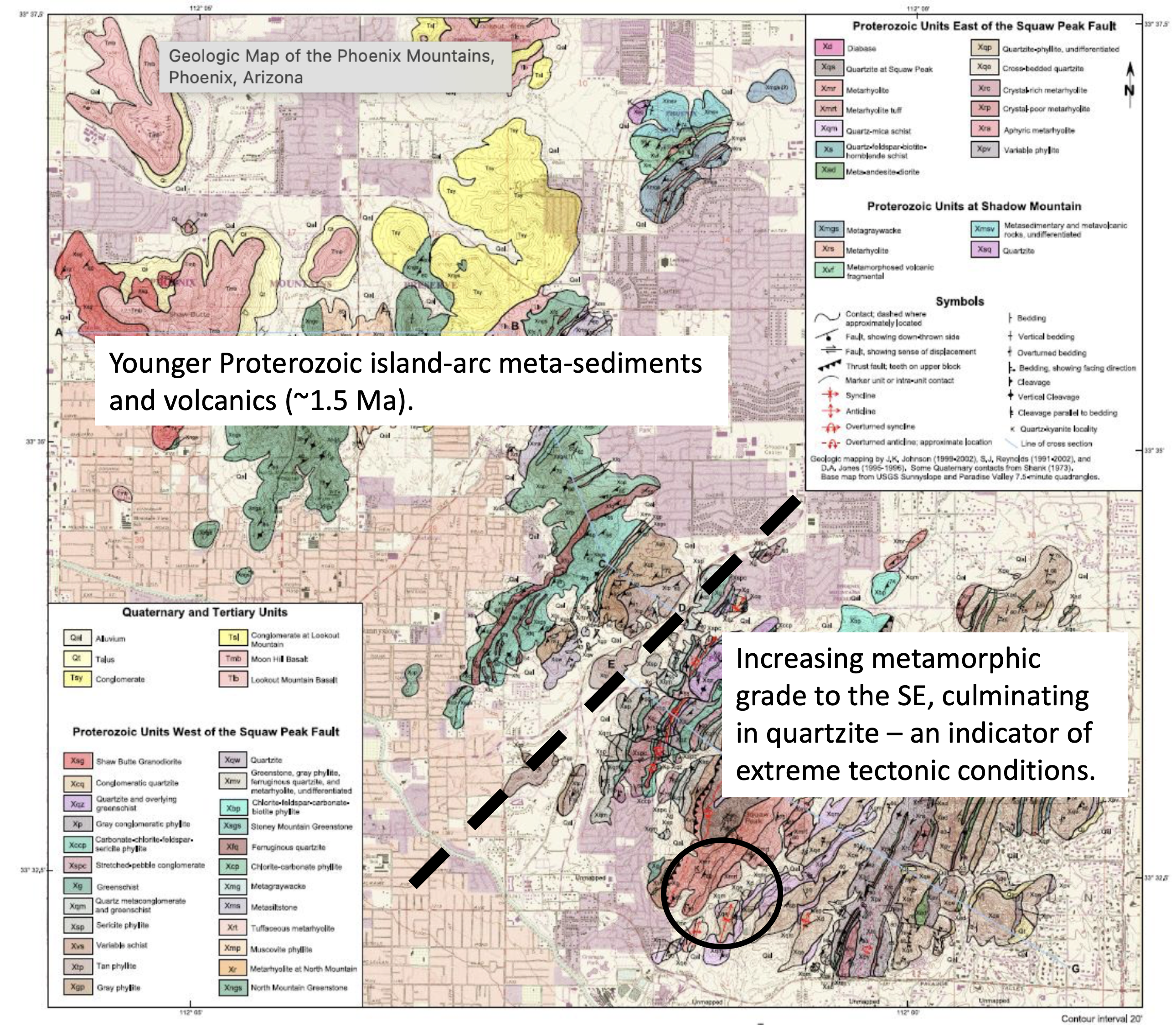
Today’s post is from the Phoenix Mountains, a municipal park inside the city limits (Fig. 2). My geological interpretations and dates, etc, come from a report by the Arizona State Geological Survey.
Figure 2. Location of Phoenix Mountain Park is indicated by the pin marker.Figure 3. Topographic representation of the Phoenix Mountains. Note the location of Piestewa Peak (labeled Squaw Peak in the image) in the center of the outcrops.
To the west (left of Squaw Peak in Fig. 3), a deep fault has been identified, which thrust the metasedimentary rocks comprising the eastern part of the range into juxtaposition with the metavolcanic rocks of Stoney Mtn and other outcrops to the west (Fig. 4).
Figure 4. Geologic map of the Phoenix Mountains. The dashed line indicates the approximate location of a fault that separates older Proterozoic rocks, with a higher metamorphic grade, from younger rocks.
Today’s post is focused on the circled area in Fig. 4 which, if we look back to Fig. 3, is the highest peak within the Phoenix Mountains. I was intrigued by the view from the parking lot (Fig. 1), and compelled to explore this fault-block in person. Note that the area discussed in this post in contained within the circle in Fig. 4.
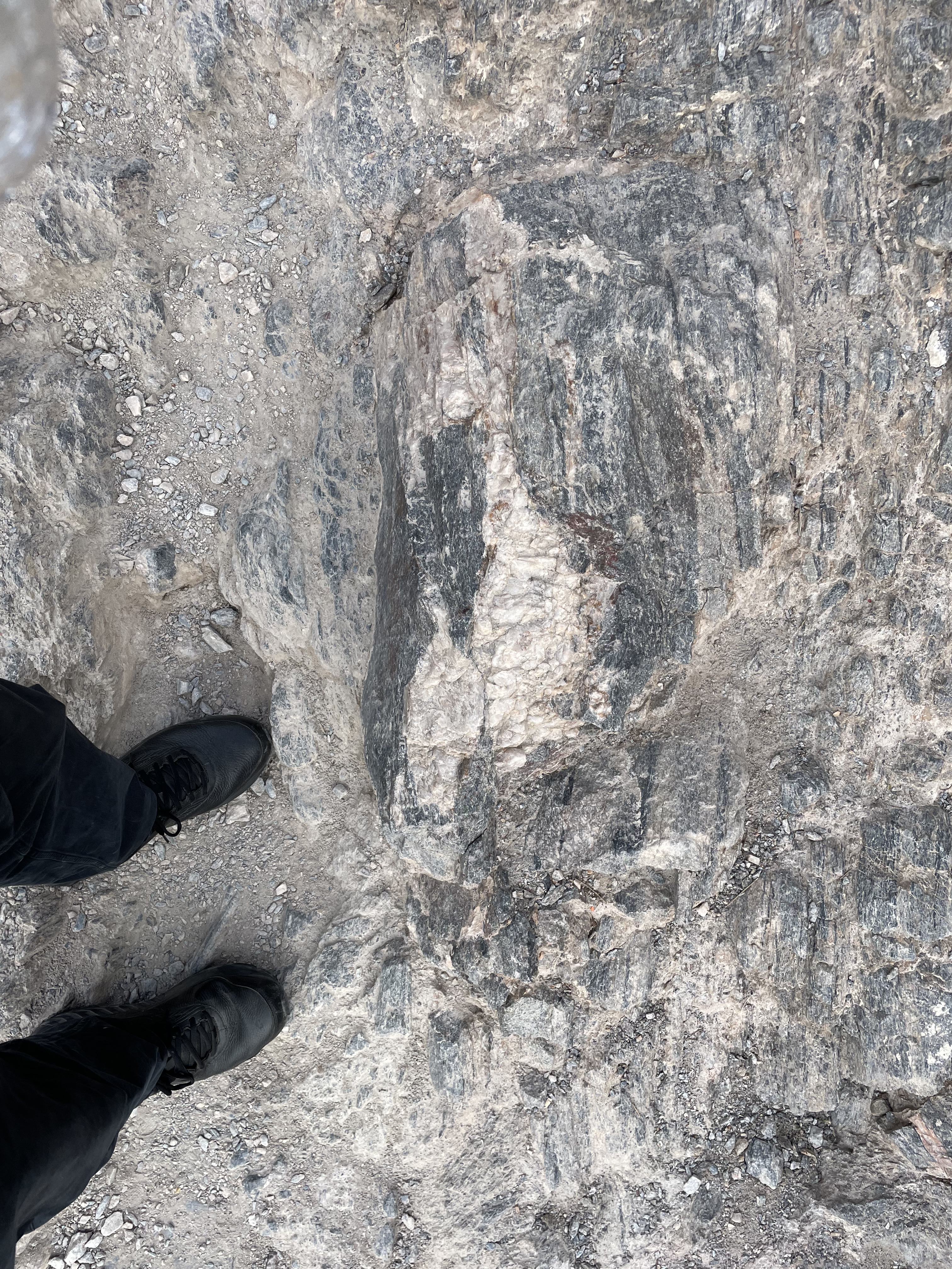
The geology of Piestewa Peak is relatively simple. Schist. In this case, the metamorphic grade isn’t too high and the rocks preserve much of their original thin-bedded layering. However, they are standing on end (Fig. 5).
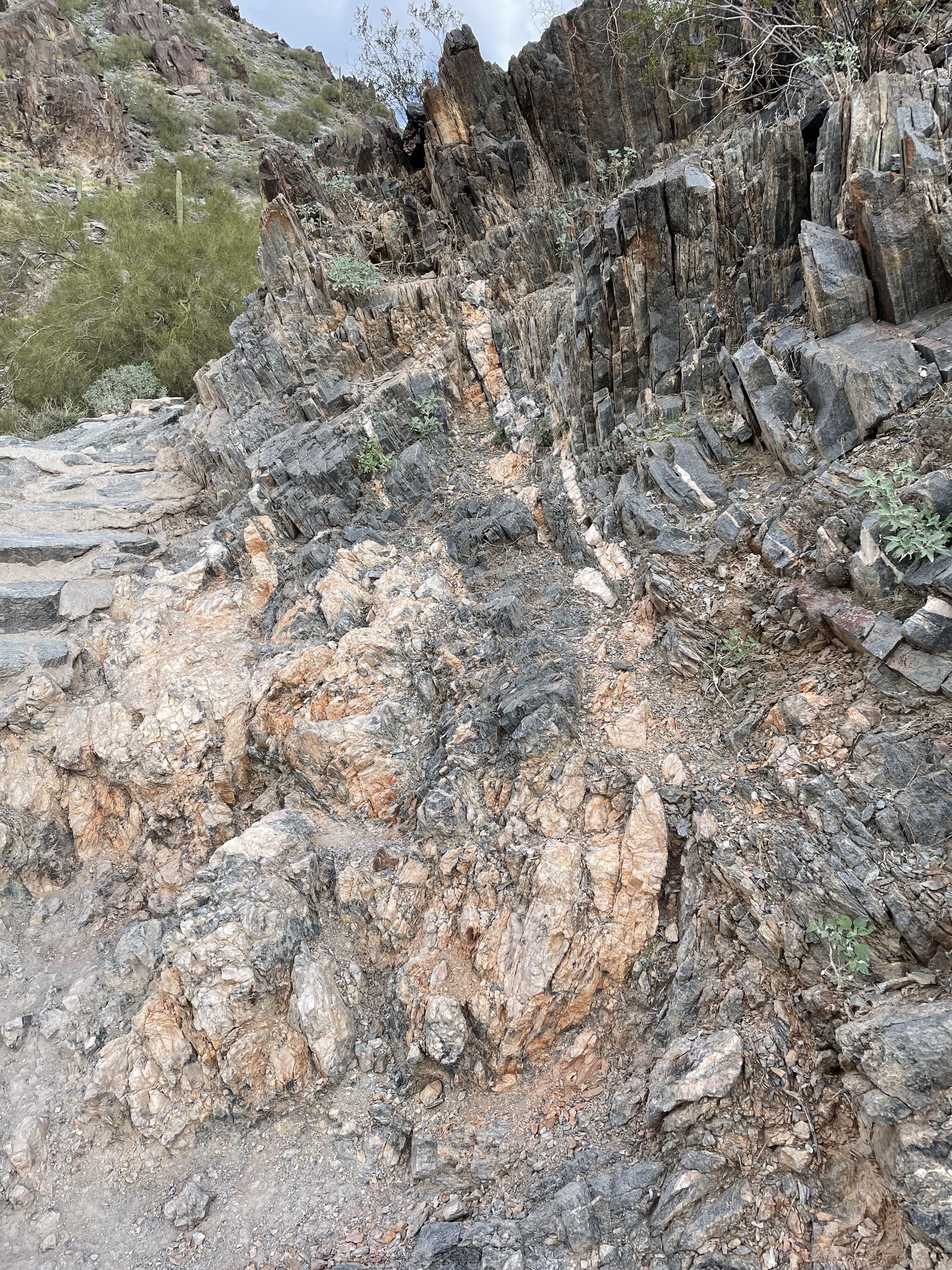
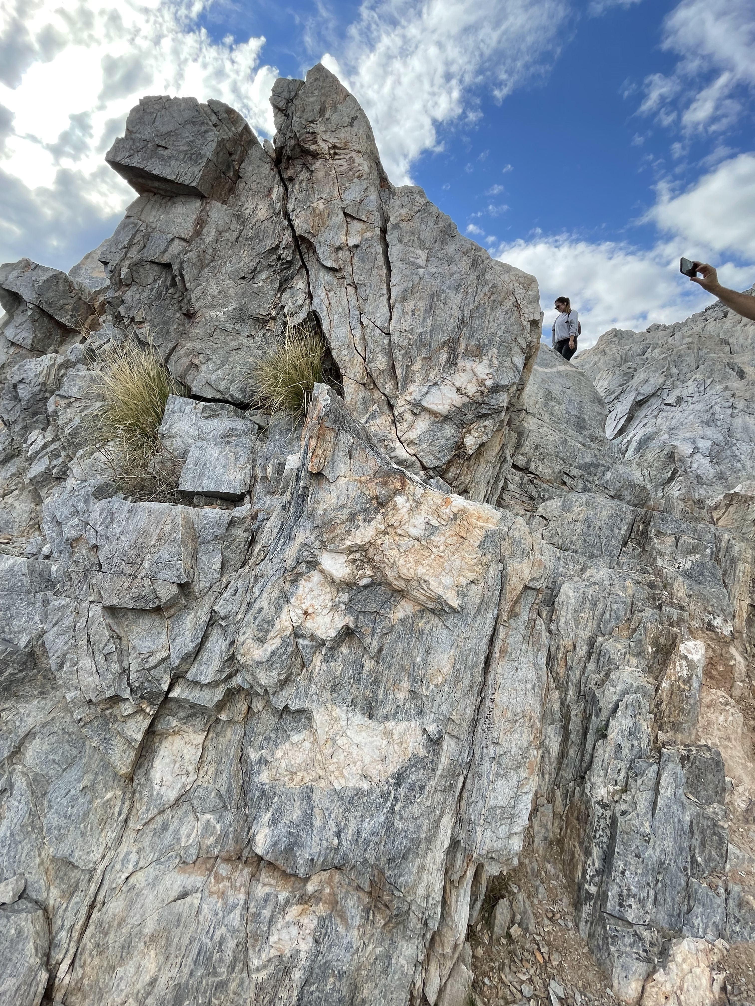
Figure 5. Exposure of metamorphic rocks in the lower part of Piestewa Peak. Sedimentary rocks were metamorphosed to a medium grade schist about 1.6 billion-years ago. The vertical lineation seen in the photo is caused by the characteristic alignment of platy minerals like muscovite mica.Figure 6. View looking obliquely along the primary foliation of the schist, showing the preservation of primary sedimentary textures in the thicker layers near the center of the image. Note that the metamorphic fabric is not as steep here as in Fig. 5. Foliation varied by tens of degrees within the study area. Note the curvature of the layers, evidence of folding during a deformation event that may have coincided with metamorphism. A lot can happen in a billion years.Figure 7. The foliation is nearly vertical at this location, much further up the trail than Fig. 5. However, the layers are fused more tightly and schistosity is reduced. Note the cross-cutting layer running from the center of the photo to the right, as well as the lighter-colored rock that is pinched in the center. This locality reveals multiple deformation events, including the intrusion of magmatic fluids rich in silica (i.e. quartz and feldspar).Figure 8. This beautiful photo shows the preservation of primary sediment texture in the darker layers to the upper right. Lamination can be seen within each layer. Primary sedimentary texture and the metamorphic foliation are aligned. A second feature of this exposure is the complex relationship between the country rock (i.e. the schist) and the pink material invading it along bedding planes. Note the massive but jumbled appearance of this intrusive rock in the lower part of the image whereas it has been confined to thin veins in the upper part. This image and Fig. 7 are evidence for the occurrence of multiple metamorphic and intrusive events. Injection of granitic veins would have been later than the relatively low-grade metamorphism that produced the schist.Figure 9. This photo shows the sharp contact between the intrusive granite (the orange hue suggests a potassium-rich source) and the schist, which would have been much older by this time. This is a thick vein that apparently is directed vertically, as suggested by the lack of a trace in the background. Figure 10. Photo at the top of Piestewa Peak, showing the lower, eastern peaks of the Phoenix Mountains. Note the lack of erosion of the rocks exposed at the summit in this arid climate. Figure 11. Image of nearly vertical schist intruded by granitic veins that cut across metamorphic and/or sedimentary lineations. Although I made no geometric measurements, I think this outcrop is approximately aligned with the veins shown in Figs. 8 and 9; if so, this could be near the termination of a splintered offshoot from the magma chamber that cut into these older metamorphic rocks. I didn’t find any ages for this granite but it is definitely younger than the 1.6 Ga schist, simply because it cuts across bedding planes and metamorphic lineations.
Summary
There isn’t much to say about this post after my road trip to Prescott, and then a hike in the White Tank mountains. The first thing I can say with confidence, however, is that Squaw Peak (aka Piestewa Peak) is squarely located within the Basin and Range, defined by faults that have brought disparate rocks into juxtaposition, but only in a small area. The Phoenix Mountains are nothing like the vast, overlapping fault-bounded mountains of the Central Highlands, but instead they are isolated in a sea of sand and gravel, sediment eroded from the long-gone rocks that encased them for eons. There was no superimposed shear evident in these rocks as in the White Tank mountains. They just rose from the earth’s bowels along nearly vertical faults.
These rocks aren’t as old as those we encountered in the Central Highlands — by about a billion years. Nevertheless, they suggest that plate tectonics determined the history of central Arizona, even so long ago. Because of the lack of suitable rocks, no plate reconstruction can be attempted for the Precambrian (neither a geologic period, era, or eon); thus, we can only assume that things were the same but different — upper mantle processes dragging crustal plates around, but without plants, oxygen, or animals to intervene in surface erosion.
We don’t know what happened that long ago, not to mention the billion years between the creation of these sedimentary/metamorphic rocks and the emergence of multicellular life. We can only view the rocks we’ve seen in Arizona through a glass darkly…


Recent Comments