
The Lemay Auto Collection
The museum occupies the entire grounds of a 20th century boys school, so they have a lot of cars!
A Trip to the Burke Museum of History and Culture in Seattle
I’m reposting some Facebook posts from recent excursions around the Tacoma area for now.
Trinity House
Trinity House was written during the Covid pandemic and thus expresses my frustration with the divisions I was watching grow within American society. I didn’t want to write a dramatic story but that’s probably what it is. As the author I accept full responsibility for this dark comedy that attempts to explore the relationship between superstition and innate human behavior.

The professionally done cover encapsulates what is wrong with extreme religious beliefs. One side of the church’s lawn is well kept while the other is overgrown with weeds, the tree dying, yet the gardener is waving as if there were nothing wrong, oblivious of the damage he has done by his own acts. But he isn’t happy, far from it; his demons are haunting him.
I tried to capture the complex social environment of deeply conservative Christians torn between their dogma and the reality of life, the neighbors they are equally capable of loving or hating. I personally love the ending, but then I’m an agnostic, maybe an atheist. At any rate, it felt good to get yet another burden off my chest.
Publications: Deep Dives into Science Fiction
I’m not reposting these book descriptions in chronological order. They were originally written as my interest changed through time and in response to the news. This post focuses on four science fiction novels inspired by the news, and my visceral reaction to the simplified reality portrayed in pop culture. Thus, my attention turned to early reports of Artificial Intelligence, as Large Language Models were presented to the public. All the hype about deep-learning algorithms becoming intelligent after being trained on vast amounts of publicly available books, movies, images, etc. bothered me because, if the objective (intentional or not) is Artificial General Intelligence, these programs all missed the boat. For example, a human brain isn’t fed a stream of data to become the cognitive wonder we claim to be; it spends years processing and assimilating sensory data–touch, hearing, smell, sight, taste. So I imagined what might be occurring in a private lab somewhere, an event so profound it would change the course of civilization. It remains entirely possible that a scenario like that portrayed in Aida is actually playing out below the radar of mainstream media attention.

AIDA is an acronym for Artificial Intelligence Daughter Algorithm. It is the story of a heartbroken computer scientist who decides to create a daughter to replace the one he lost, along with his wife, during childbirth. But his creation exceeds his wildest expectations. The simple cover encapsulates the central theme of the book. Look at the picture closely and you will find that the beautiful woman depicted in the left side of the face is matched by an evil countenance on the right. There is no purpose in issuing warnings about unintended consequences because humans never look beyond the immediate horizon.
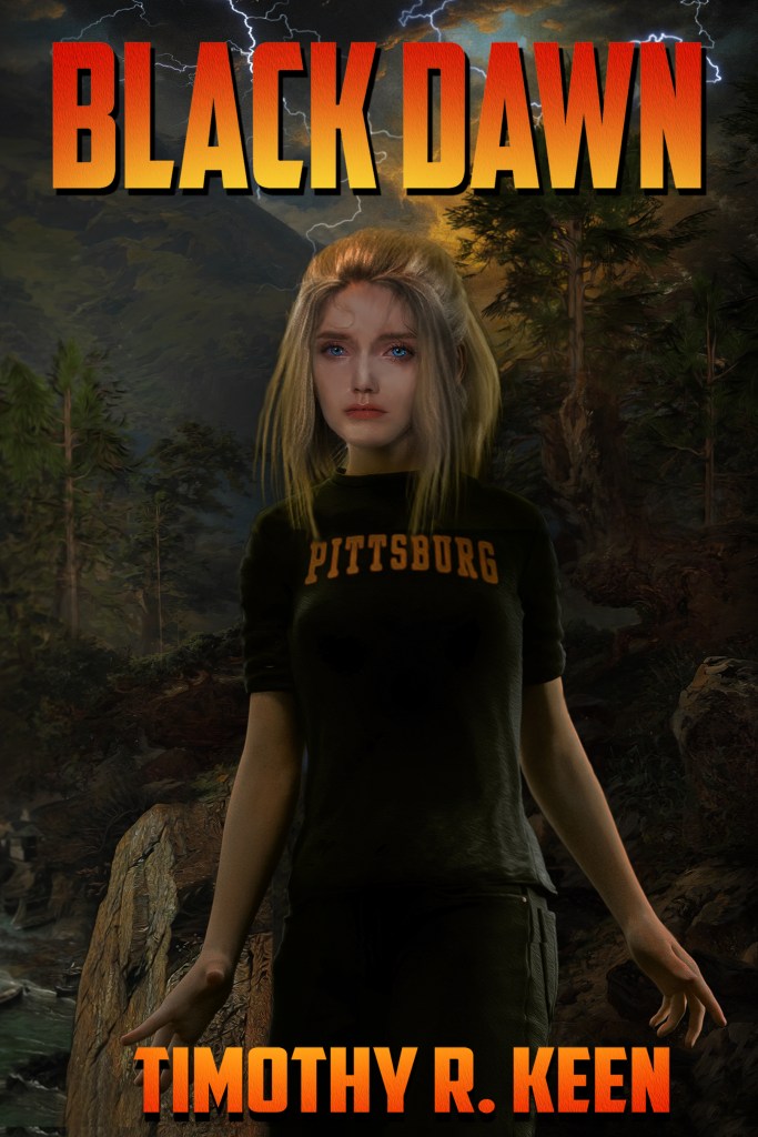
Writing Aida got me to thinking about AI and robotics so, naturally, I wrote another book on the subject. I wondered what would happen if an AGI hooked up with an advanced humanoid robot. One possibility is encapsulated in the title of this novel: it would be a Black Dawn for humanity if the wrong people got their hands on it. I wanted to call this book, AMANDA, the name of the central character. As you might have guessed that is an acronym–AMANDA is an Autonomous Mobile Anthropomorphic Neural-synthetic Deep-learning Architecture that has spent 16 years being raised as the daughter of a couple of computer scientists.
The naive Amanda needs a guide for her intellectual and emotional journey when her family is murdered and her body stolen. To add an interesting twist to the tale, I reintroduced the elderly writer from A Change of Pace as the author of the novel that influenced her parents: Aida not only impacted AMANDA’s creators, it also leads to its author (Jim Walsh) being pursued by the bad guys. Naturally, Amanda and Jim become unlikely partners in a quest of personal importance to both of them.
This is an adventure that doesn’t slow down until the end.
Apparently, I needed more adventure after writing Black Dawn, so I wrote a what-if novel about what might happen if the basic laws of physics, or the constants we take for granted, were to change. The result is Broken Symmetry, a story about a graduate student who finds herself the locus of a bizarre chain of correlated events–personal, social, and even geological–with no obvious causation.

The action in this story is too cataclysmic to keep under wraps, not when the San Andreas fault ruptures and Yellowstone caldera explodes, but that’s only the geological story. People begin to change and someone wants to stop the contagion. (Don’t they always?)
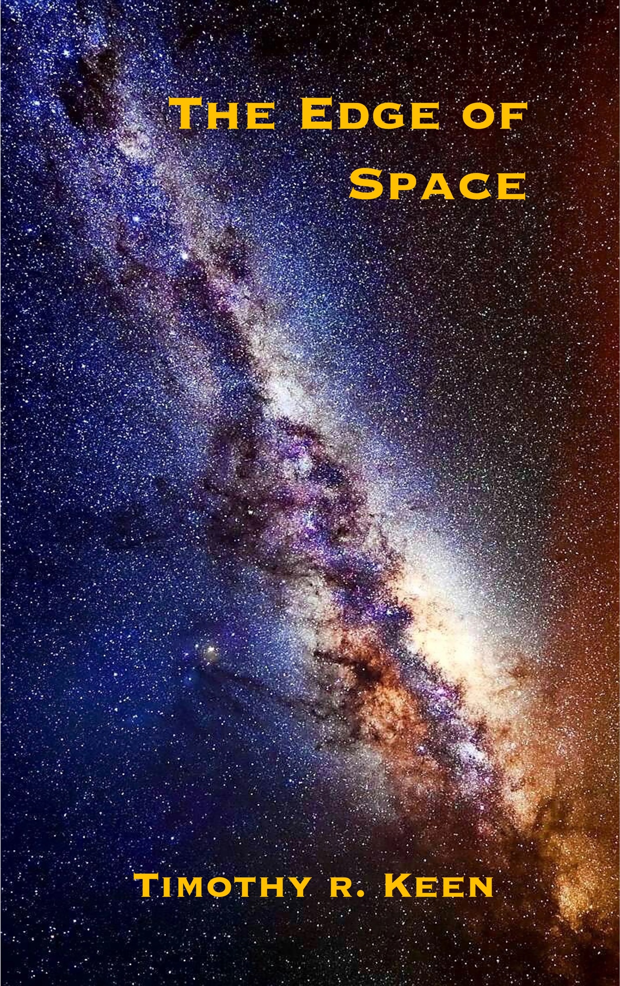
The Edge of Space was my response to a news story about Voyager One having communications problems after exiting the solar system. The story is told through the eyes of several characters with different perspectives. Their interactions are rife with speculation about what is occurring, from a young woman from Thailand to the president of the United States. As the story unfolds, these characters move in and out of each other’s lives.
I have written an outline for a sequel to this story of First Contact…
Publications: A Change of Pace
As much as I enjoyed writing the Unveiled books, I was ready for a change and, besides, I had some more issues to work through. I’m not generally a conspiracy fan but 9/11 got everyone’s attention, especially with that whitewash report the federal government produced. However, in Night Shift, I got distracted from the conspiracy theory and really dug into a tragic relationship between two people who couldn’t have been more different.

This book was a lot of fun to write, even though part of the story was tragic. I felt as if I knew Faheem and Sofia personally by the end. What a crazy couple, but they stuck it out despite their differences and what was happening to them, most of it their own fault. I’m still not certain if Faheem stumbled onto the truth…
I did a lot of reading about psychology and behavioral disorders while writing Night Shift; so, naturally, I was inspired to write about myself, not in an autobiographical style but more as a novel with a central character who could be me. Thus, A Change of Pace was created to write about myself anonymously. There’s a little biography in there but not much; nevertheless, Jim Walsh is as close to me as I can imagine a character. I also noted some eery similarities to my life that were not intentional. Perhaps writing a pseudo-autobiography was therapeutic after all.
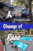
The cover sets the stage for this light romantic comedy about a fish out of water. Besides jumping from action/adventure to romantic comedy, I also did the cover artwork myself. I had used the same studio for the previous four books but this one seemed too simple for their expertise (they specialized in hand-painted fantasy art). Thus, the cover features the motorhome I was living in at the time and my old Land Cruiser, but I never lived in an upscale apartment in my life. That part is fantasy.
I love writing novels because it’s like binge watching several seasons of a favorite show and getting to know the characters intimately. There is so much that can’t be squeezed into the final text. Still, it can be fun to explore a stranger’s life for a few days, a span of time too brief to really get to know them, yet long enough to reveal something significant about their lives.
I took a break from writing novels to write a series of short stories that shared a common theme, which developed while working on them. I collected them together into Class of 1974. Imagine the different lives of people who graduated high school the same year, but had nothing else in common; until they all won the lottery.

These stories share two common themes: the title implies that the stories are tied to a rather dismal year in recent American history; the second commonality is more dependent on luck. I created the cover from a stylized Escher staircase showing people going nowhere, which seems appropriate for my cohort.
I think every writer should write short stories between major works. It’s like writing practice. And short stories are a great break from the concentration necessary to complete a novel, not to mention the lengthy timeline. I think the idea for Mirror Images originated in a dream (I can’t remember for sure) with a lot of images flashing past, nothing recognizable; it may have been my waking memory of a series of static dreams. At any rate the eventual result was a collection of stories sharing as many mirror metaphors as I could think of.

I fell in love with this photo I found on Shutterstock because it conveys so much in a simple black and white format, and it was a large image so it could be used for the entire paperback cover. Mirror Images contains a couple of stories I don’t care for (unhappy endings) and several I loved writing and enjoy reading over and over. I’d love to hear what you think.
That’s enough for this reboot post. Next time we dive deep into science fiction.
Publications Reboot
INTRODUCTION TO PUBLICATIONS
I’ve made a slight adjustment to my web page. Publications will now be automatically updated like a blog post (aspirational at best). This change will allow me to add comments upon reflection of my writing, which is an evolving process; however, it also gives me an opportunity to standardize the web page–I hate inconsistencies of every kind.
This first post in the Publications category is a summary of what was on the old web page. I’ve added a little here and there. Let’s begin at the beginning…
THE UNVEILED SERIES

Awakening of the Gods is the first book I wrote. I was inspired by watching documentary shows about ancient aliens. It was supposed to be a short story, but then well… I felt like the story ended without full closure even though it was meant as a single novel.
I became interested in the history of the fictional Inauditis people while writing Awakening, so I explored their ancient background in Servants of the Gods. This was fun to write because of our poor knowledge of what society was like 47000 years ago. I also had the opportunity to work with a professional illustrator, who produced the great cover from my description.

I wrote a clever ending for this story, which required that I write a third book in the series. In truth, these books were very enjoyable to write. Exiles of the Gods picked up the story shortly after Awakening with the same characters, but the central character became Pedro who happened to be the Pope.

The most enjoyable aspect of writing Exiles was integrating time travel into the developing story. It was very complicated and may be difficult to follow during a casual read. Of course, having introduced or at least implied the existence of malevolent actors on the world stage, I put a hook in at the end that required writing a fourth book to close the story.
The story became even more complex with the introduction of more players in War with the Gods.

It was worth the effort because the entire story was wrapped up, and I even managed to introduce God, or the nearest thing to it. The fascinating aspect of writing these books was how it forced me to think seriously about my beliefs. It has been suggested by a friend that this series is the basis of a religion. I hope not.
Gravel Beaches on Vashon Island
This photo of the gravel/mud beach at Fern Cove Nature Preserve reveals a marine delta, fed by Shinglemill Creek. Unlike the mud/sand delta we saw at Dash Point, the sediment here is dominated by rounded gravel and small boulders. Mud, sand and silt form the matrix. All of this material is available from the glacial till that comprises Vashon Island.
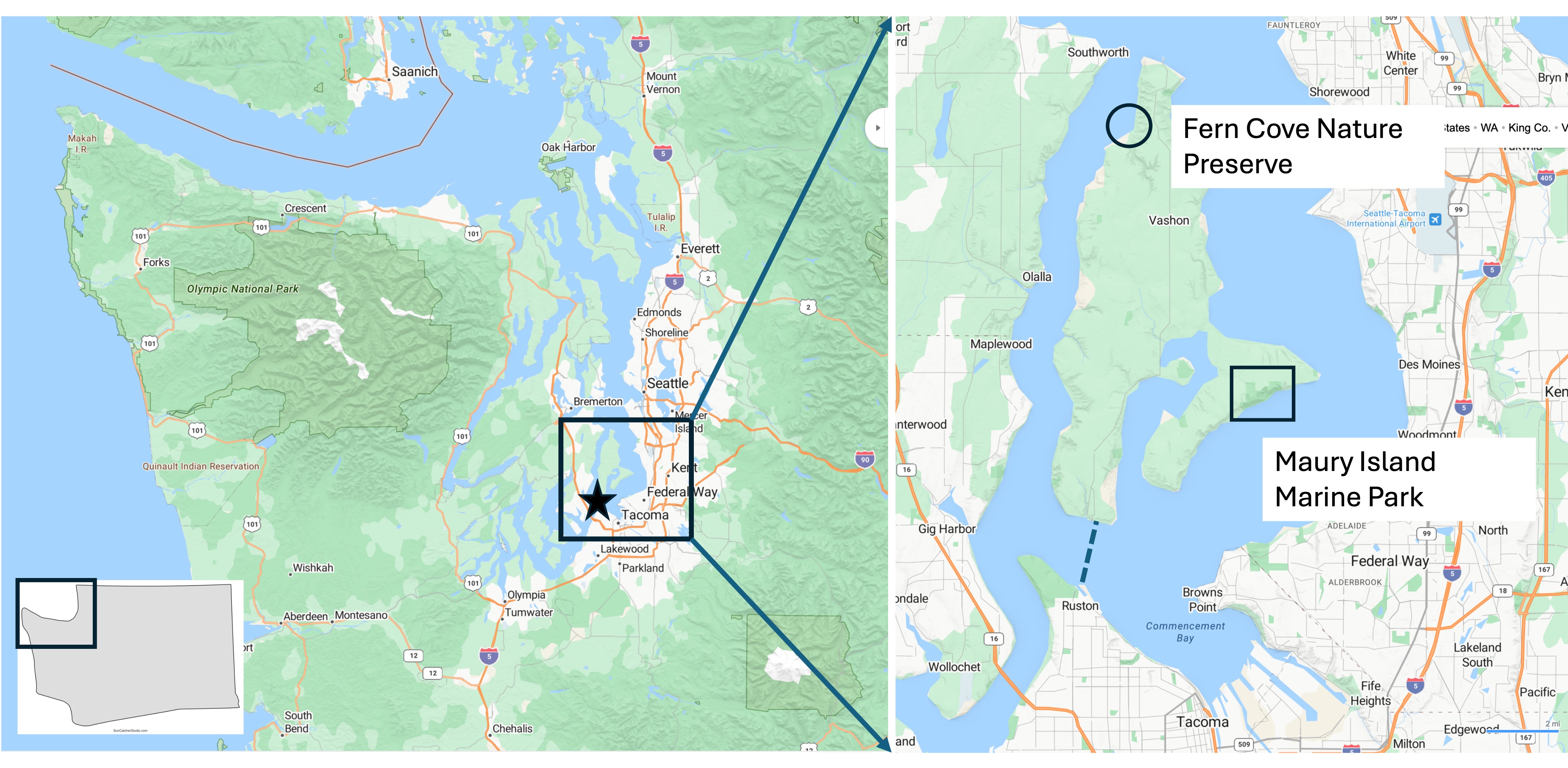
The inset map (right) shows the two sites I visited today. Fern Cove is located near the northern tip of Vashon Island whereas Maury Island Marine Park occupies the SE side of an island that is connected to Vashon by a fill zone about 200 yards across (which is eroding away as I type).
Fern Cove Nature Preserve
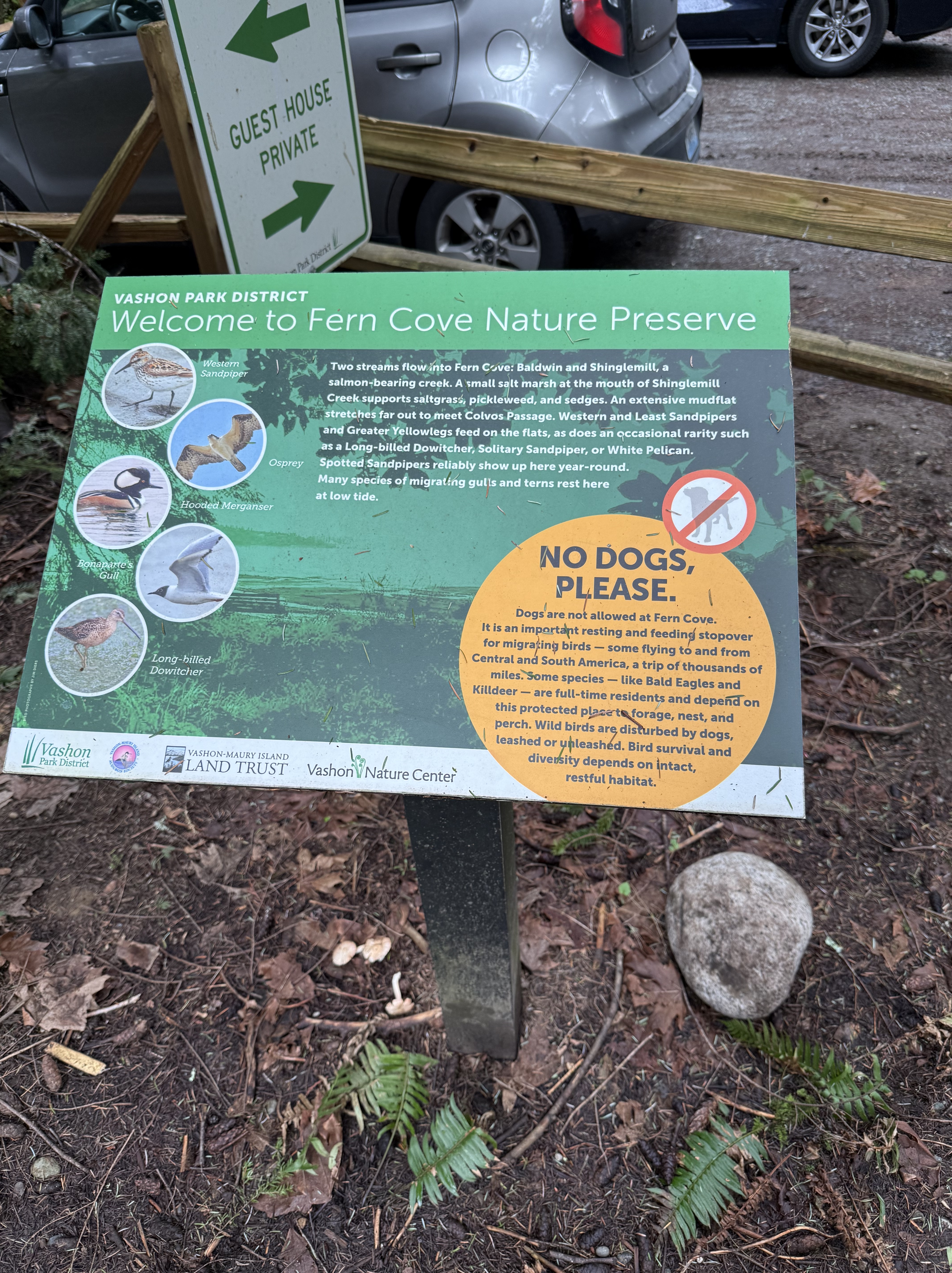
Vashon Island was logged out, so the beautiful evergreen forests that cover most of the island are all second growth. The state is trying to restore the original habitat, and Fern Cove is a good example; they don’t allow dogs!
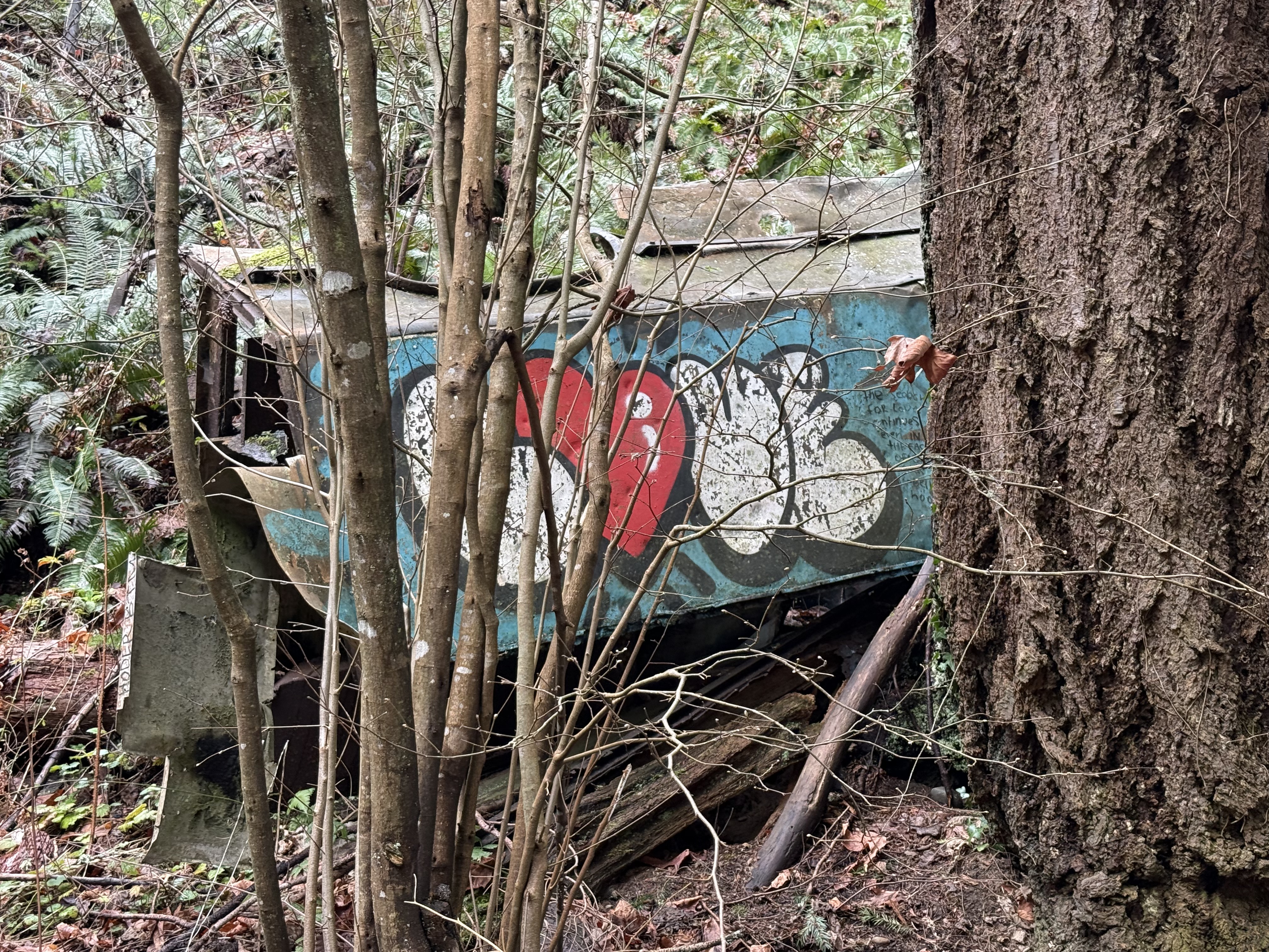
I’ve noticed that people in the Pacific Northwest (PNW) appreciate industrial art of a practical nature. I found an example here, in a threatened habitat that is actively being restored. I guess this old truck body isn’t hurting anything; I’ve also noticed that communities in the PNW don’t waste money on unnecessary actions.
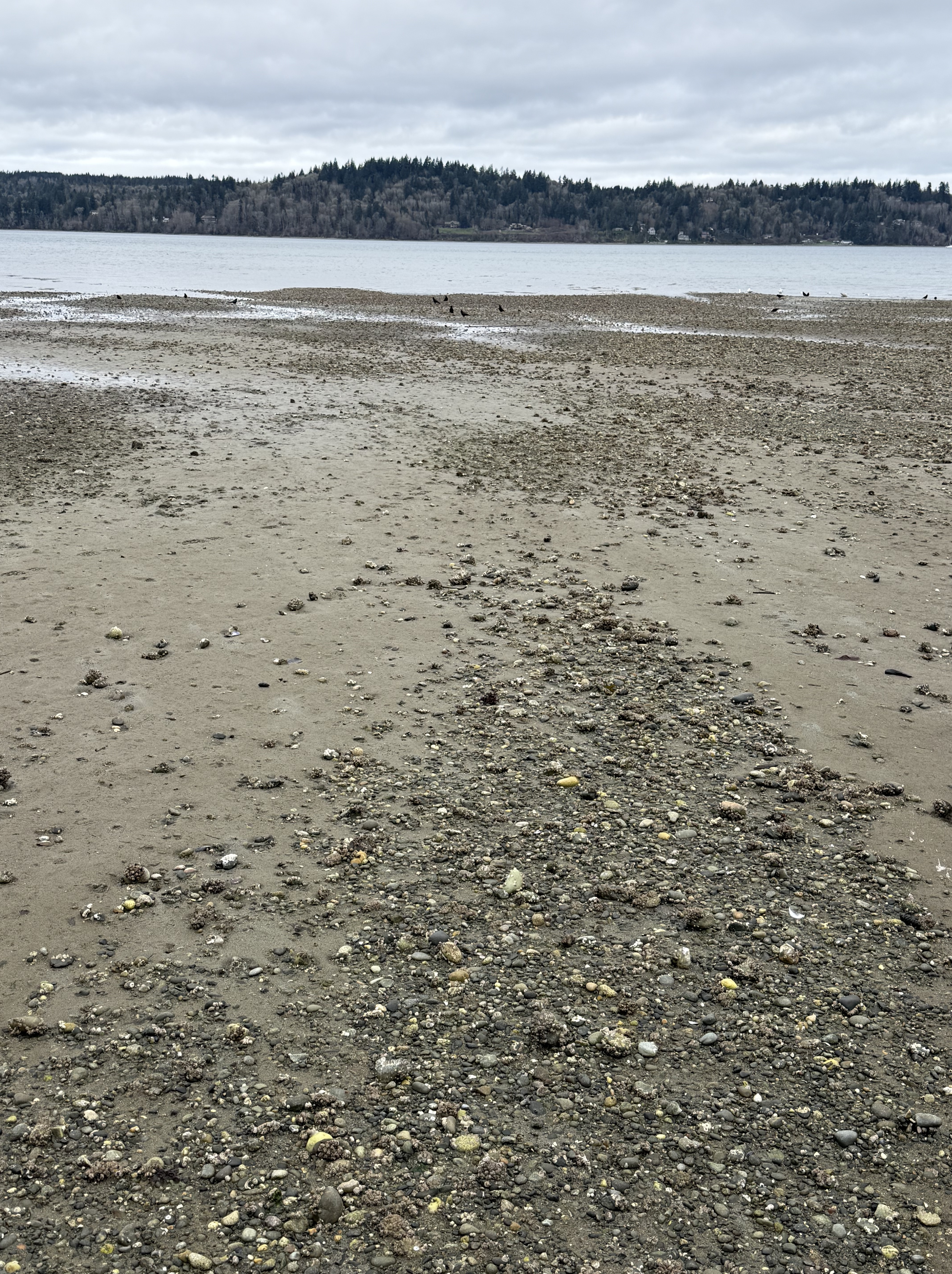
This photo shows how the gravel is localized within the delta, forming low nearshore gravel bars. The intervening areas are muddier than I found at Dash Point.
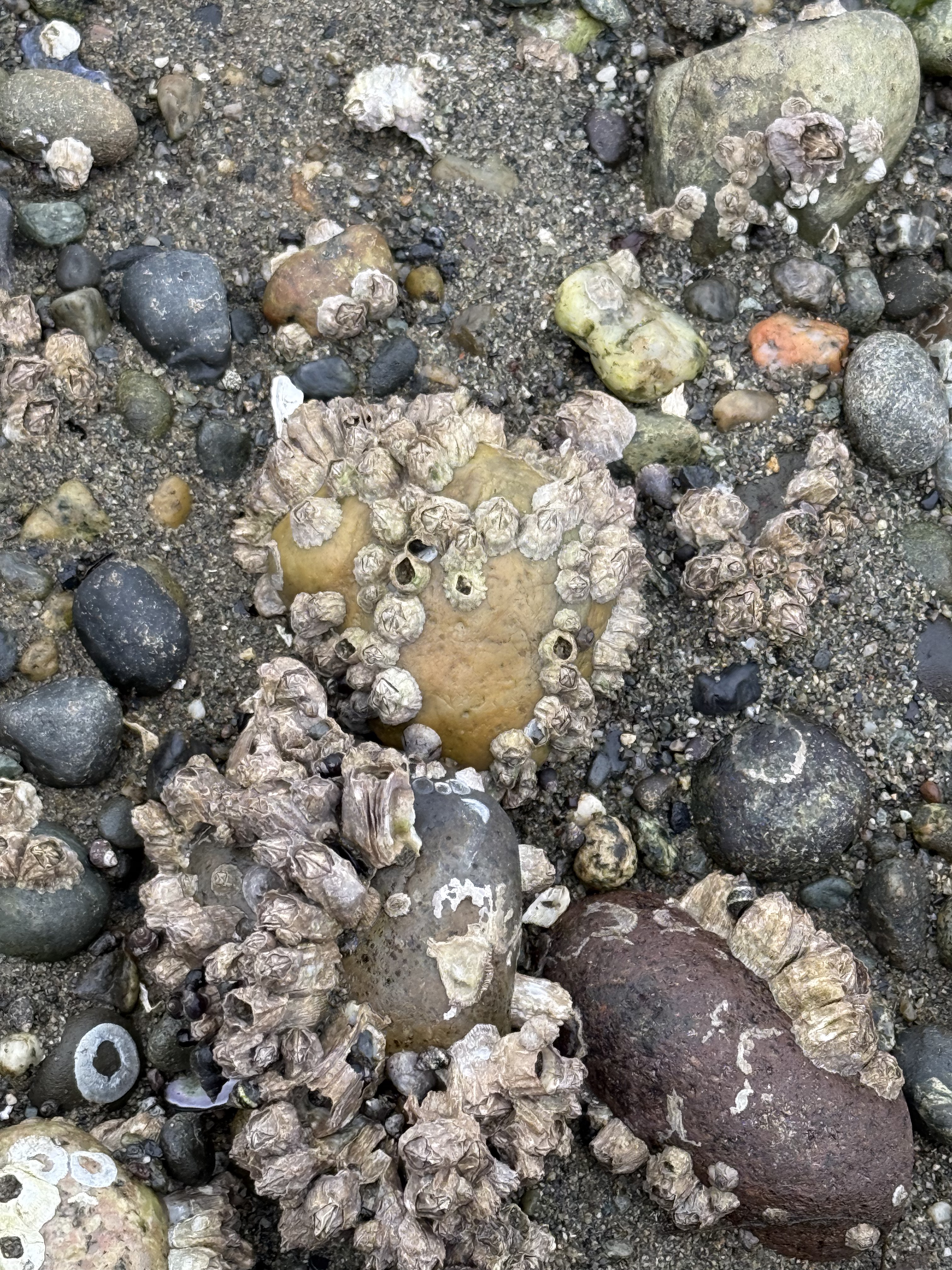
These gravel bars do more than concentrate larger rock fragments. Acorn barnacles encrust the larger ones, which are several inches in diameter. The tidal range is about 7 feet here and the beach is inundated twice daily, so I think these are living. I’ve seen barnacles on large boulders before, but I didn’t know they grew on stones. I guess the wave energy isn’t high enough to disturb them over a life cycle; their larvae must hang around after a storm and find a new rock to inhabit.
On all the beaches I’ve reported on for Rocks and (no) Roads, I’ve never seen this before. This is an active feeding area for sea birds. These are mussels, which the birds grab from a nearby mussel colony on the shallow delta front and drop on exposed gravel during low tide. The shells break open and the birds feast, leaving their dirty dishes behind.
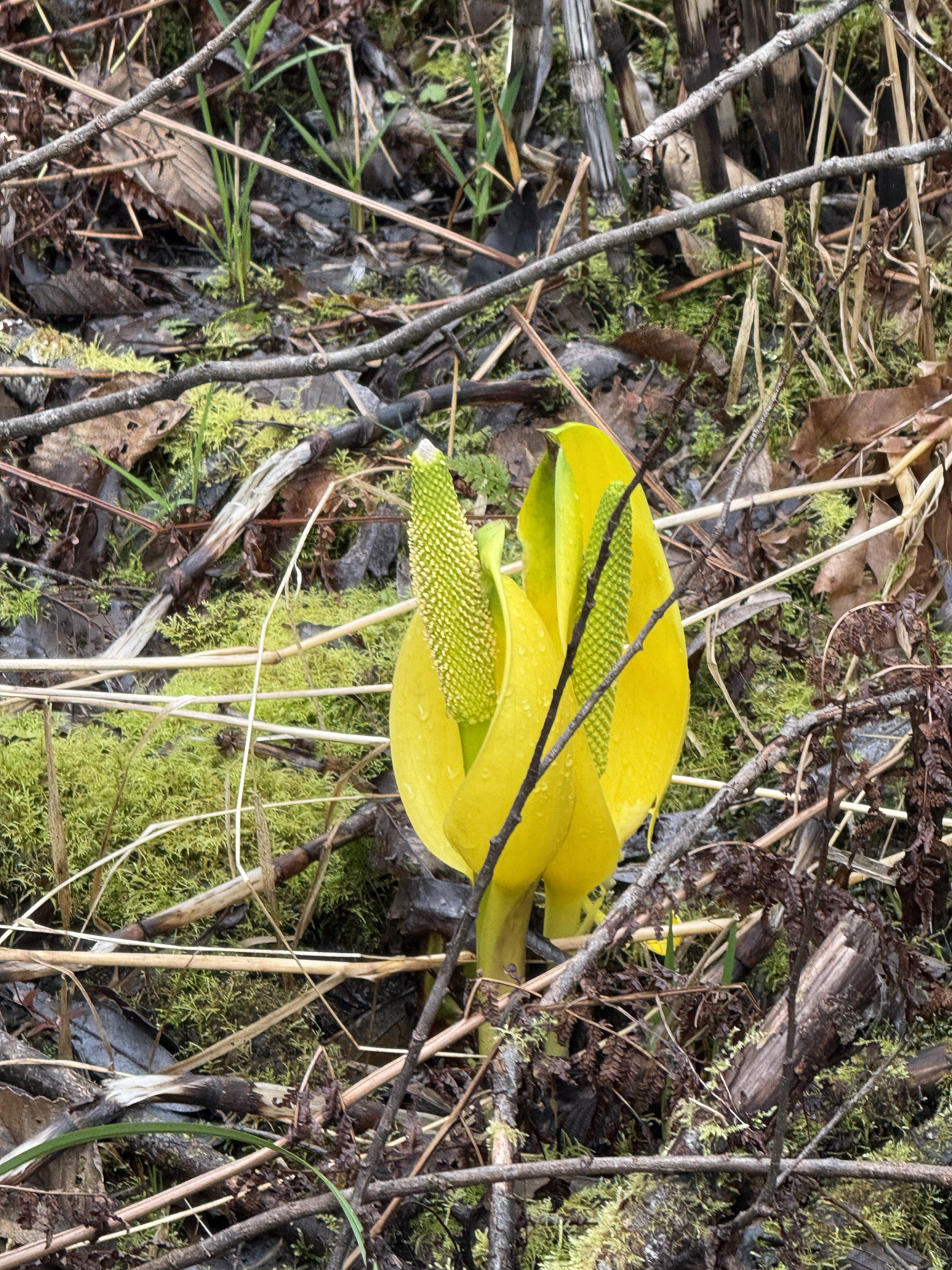
This Western skunk cabbage is just emerging from the wetland surrounding Shinglemill Creek. It will grow leaves up to two feet long, but it makes a beautiful display in the unseasonably warm late winter we’re having in the PNW.
Maury Island Marine Park
On the opposite side of Vashon Island, I visited a gravel quarry that operated for about seventy five years, before being purchased by the state as a park. This is another example of letting nature recover without interference.
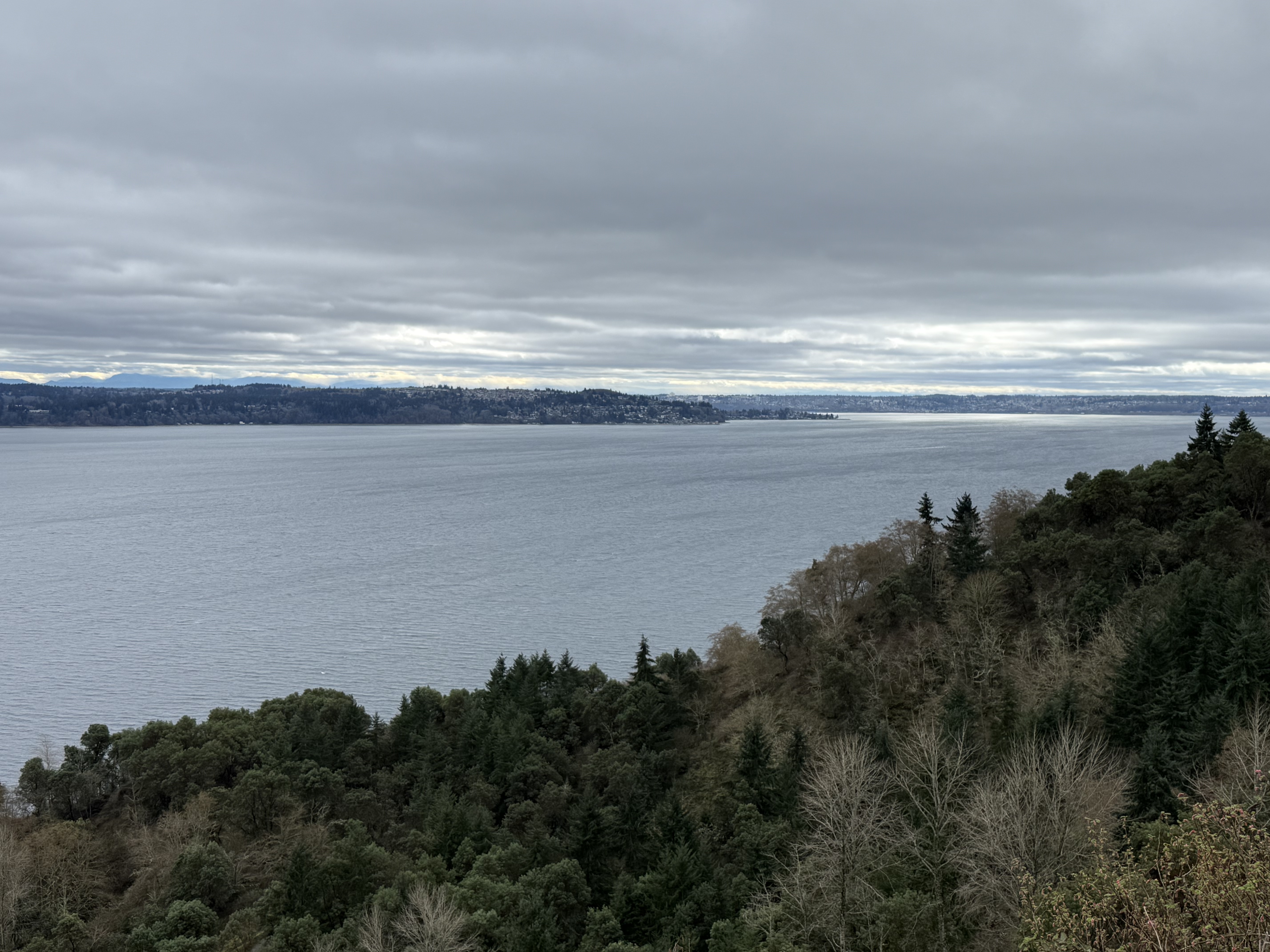
This photo looks SSE towards Dash Point. Commencement Bay and Tacoma are visible in the background; a little sunlight is shining on the bay. The cliff has been quarried for 75 years, so the 400-foot vertical face is now a steep incline with a trail that utilizes many switchbacks to reach the shoreline. Let’s see what I found…
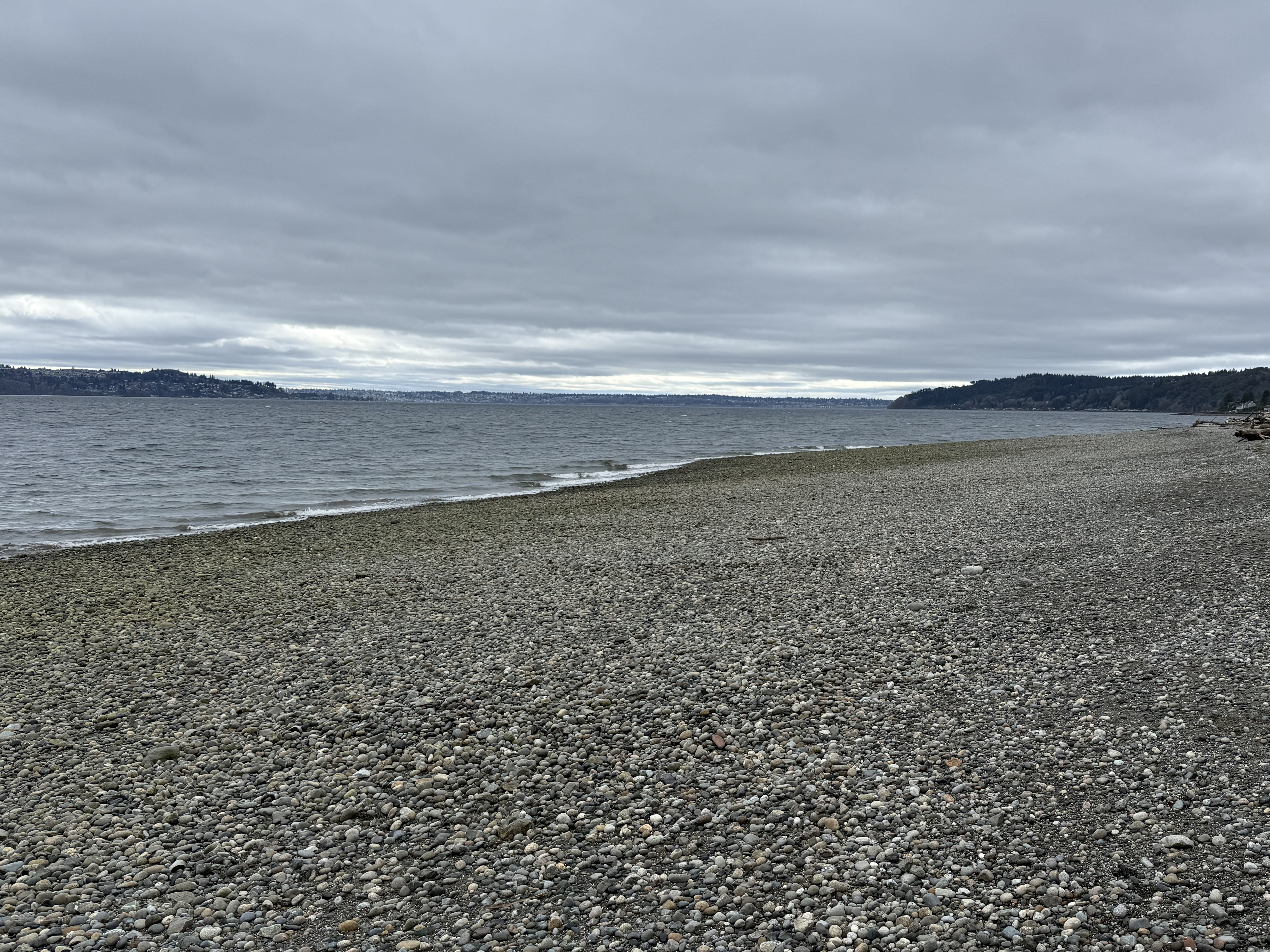
There is no mud or sand visible on this beach. I thought that might be a side-effect of so much gravel quarrying, so I walked beyond the limit of the quarry; the substrate didn’t change, but there must be lingering effects after so many decades of preferential sand removal.
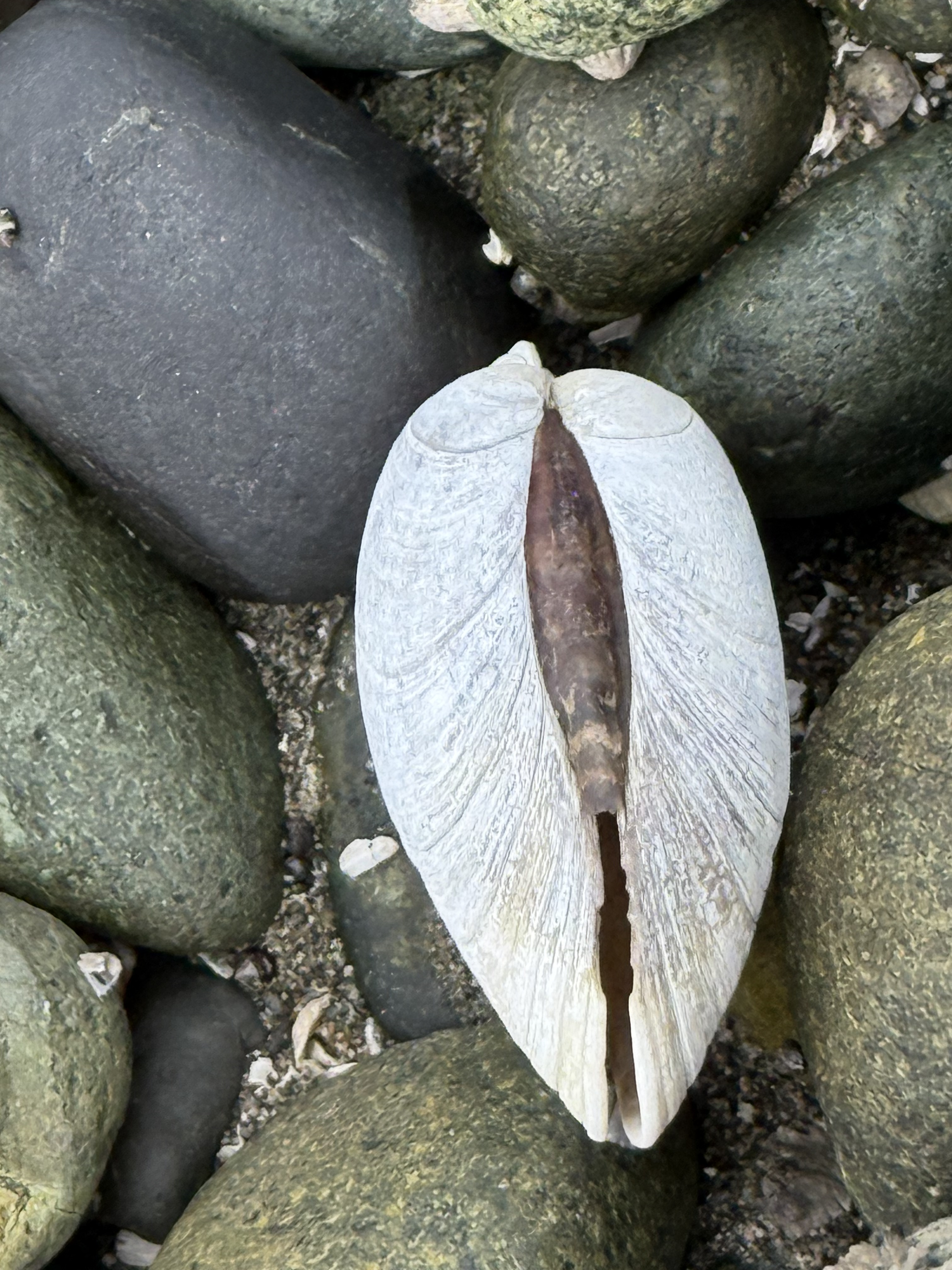
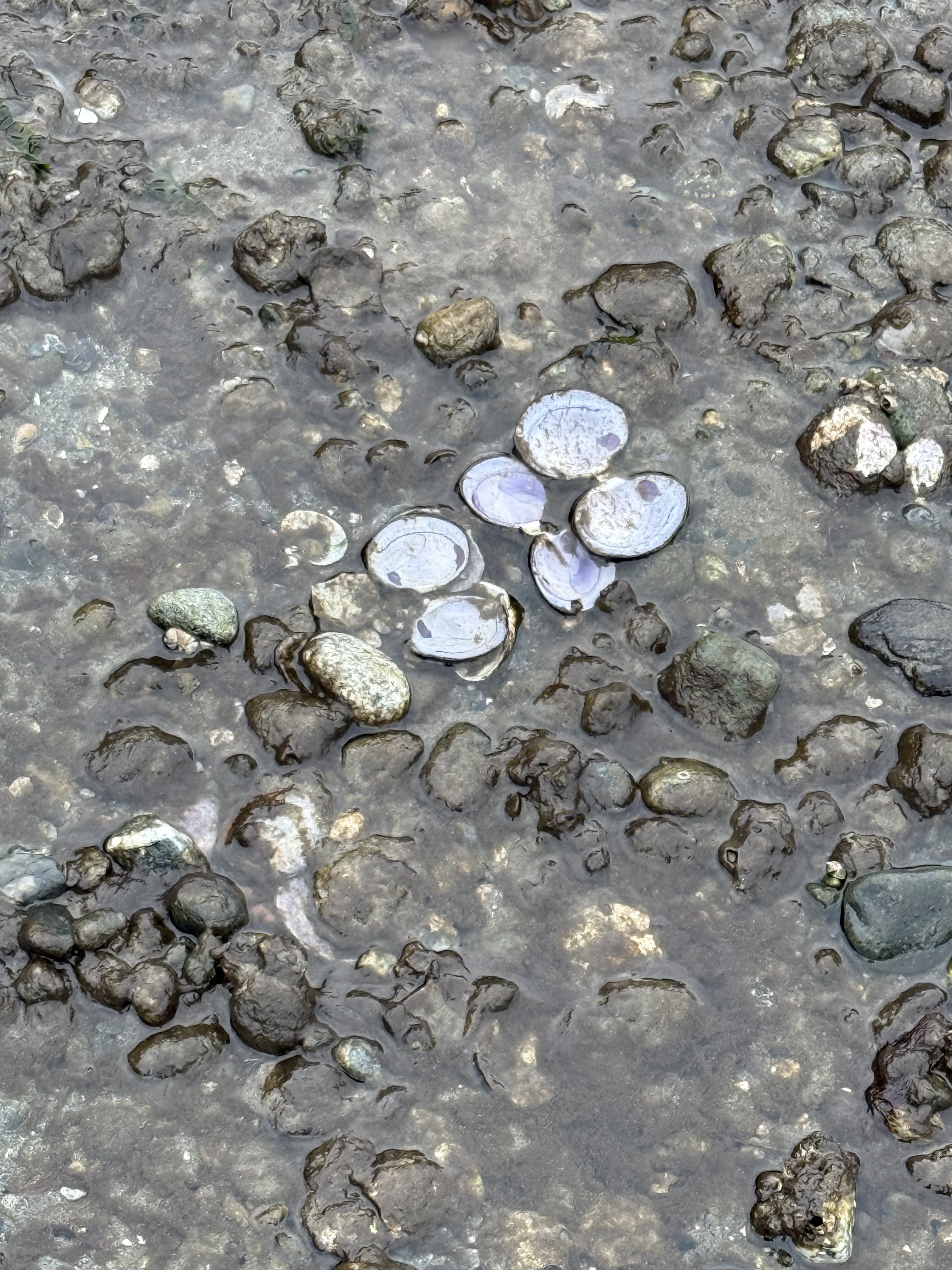
After what I saw at Fern Cove, I thought I was prepared for whatever I might find; but I never expected to see clam shells with the hinge lineament intact; this shell even closed after the bird (e.g. gull or crow) has eaten the soft tissue. The shell actually snapped shut after the animal was eaten. Amazing!
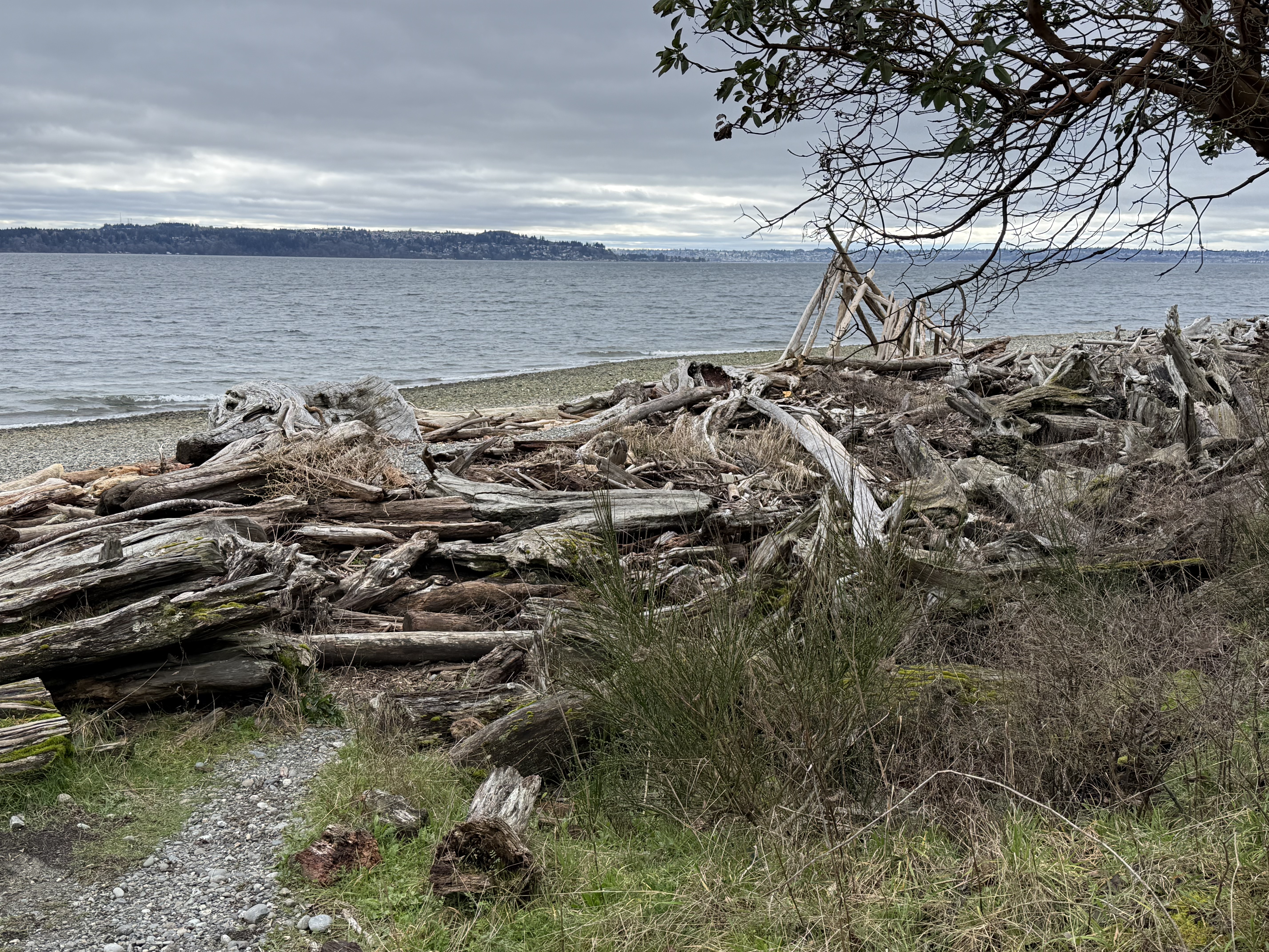
This spectacle gives driftwood a whole new meaning. Someone even built a crude shelter in the background from the logs that have collected over the years. There are a lot of trees in the PNW and many of them fall into Puget Sound, ending up all over the place. This looks like what coastal geologists might call a “hot spot”, a location where waves converge during storms.
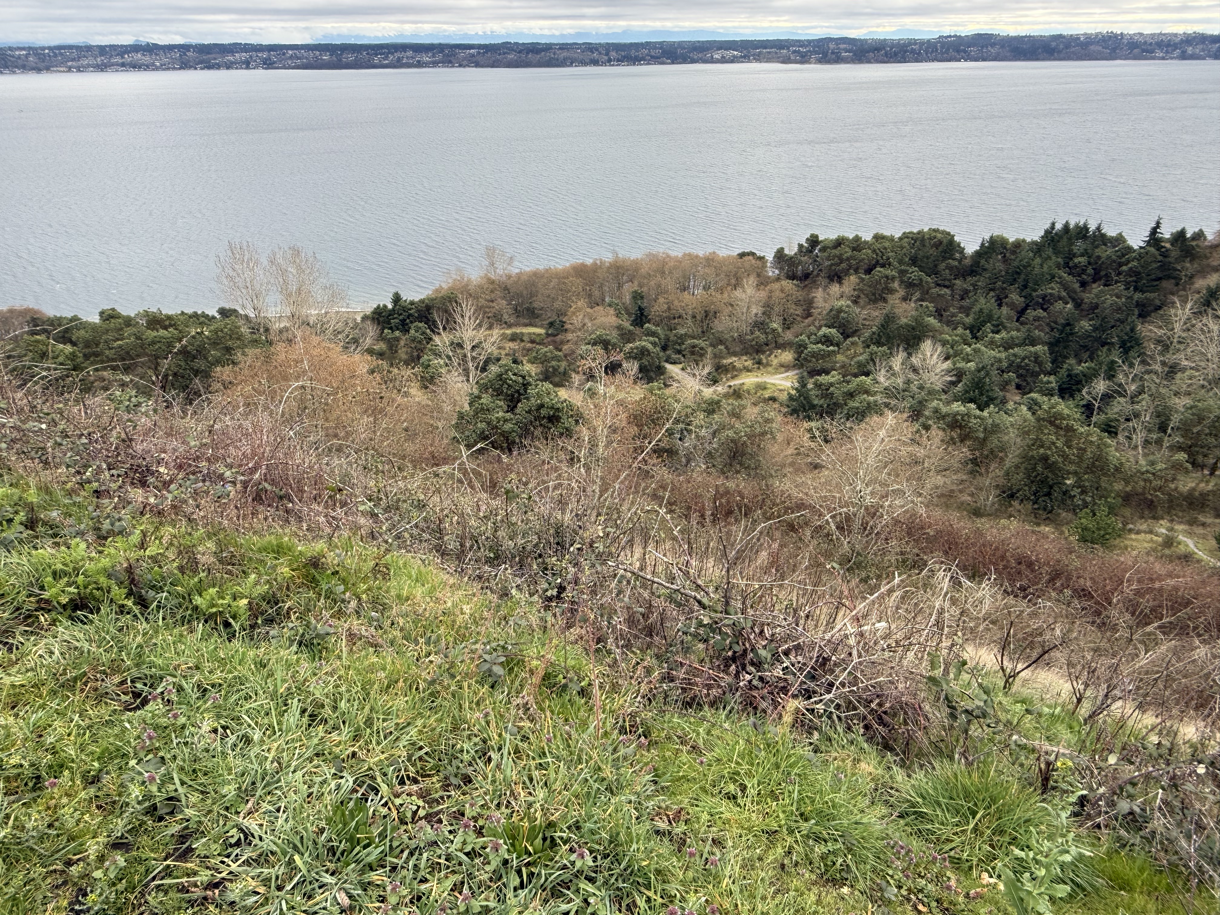
After a hot climb, even in 45F temperatures, I made it back to the top of the cliff. This area was a barren wasteland in 1975, when the state took over; park authorities and volunteers have worked tirelessly to not only allow recovery, but to keep out invasive species. I think they’re doing a pretty good job.
Summary and Acknowledgments
I learned more biology on this day trip than in my entire life. For example, sea birds eat mussels on muddy beaches and clams on cobblestone ones. They carry the hard shells in the air and drop them on rocks, breaking them open to reveal the animal hiding within. Apparently I arrived at these two beaches just after lunch, when the tide hadn’t cleaned up the dishes yet.
I’m going to pay more attention to fauna and flora in my future posts.
I don’t know anything about biology, so all plants and animals identified in this post came from CoPilot (AKA ChatGPT). I didn’t check their identifications because it wasn’t worth the hours that would have required. This is not a research paper. I’m just going out into the world and observing through my dirty, discolored glasses.
But now I can see living things…
Active Delta Accretion at Dash Point State Park
INTRODUCTION
Puget Sound is a complex water body with many channels and bays, all of them within a couple of hours drive from my home in Tacoma. I haven’t posted much about this because I’ve been overwhelmed by so many active sedimentological processes that are neither marine nor fluvial. But I had to say something about what we discovered on this short trip, less than 30 minutes from our house. Because of the bluffs (~300 feet) surrounding Puget Sound, streams draining into the various inlets and bays are short and relatively steep. There are exceptions of course, such as the Nisqually River, which flows from Mt. Rainier to the southern end of Puget Sound; however, short streams are very common although many of them have been incorporated into municipal storm drainage systems. Today, we found one that was in an almost natural state.
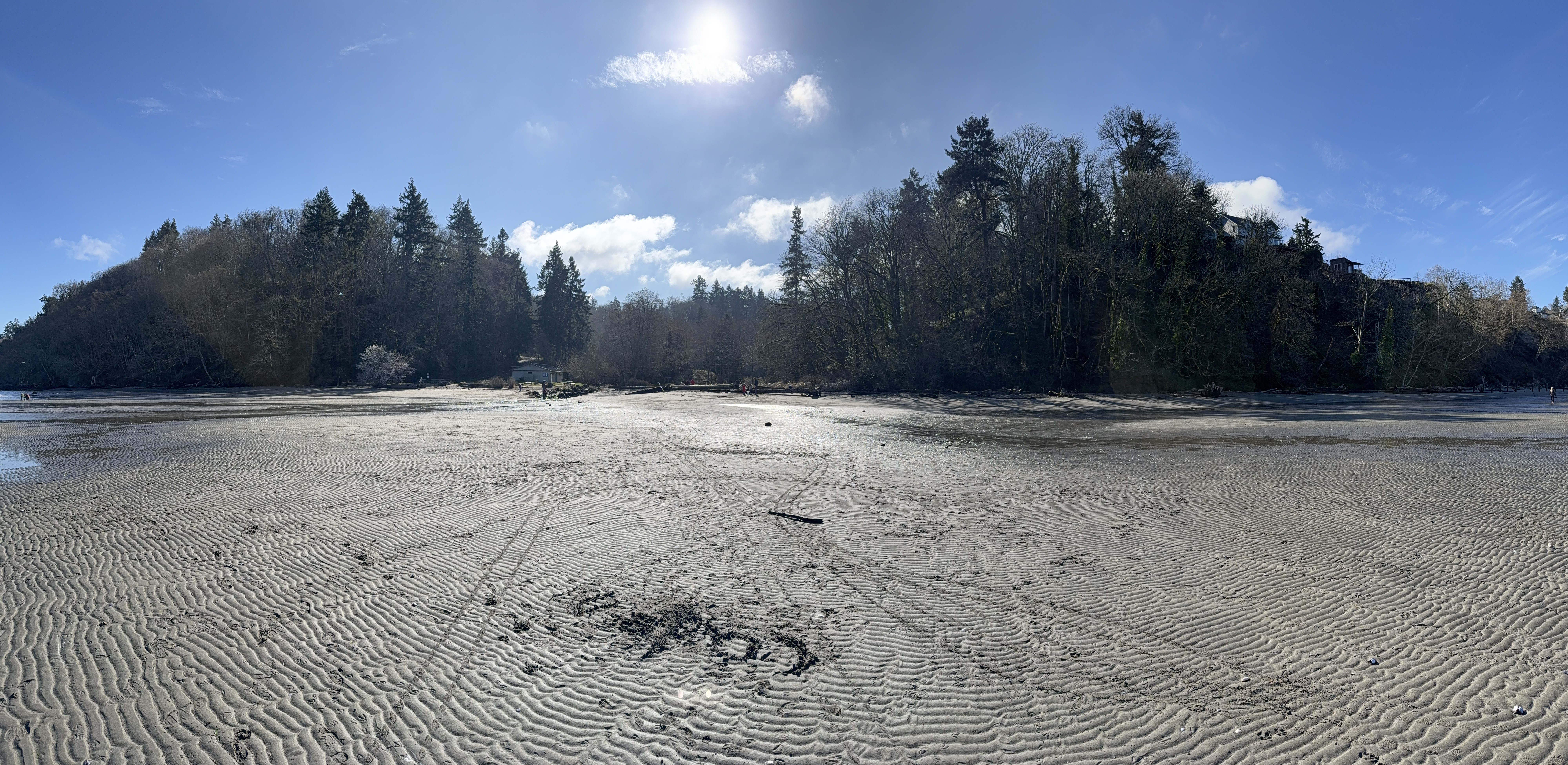
Figure 1. This photo, looking landward from Dash Point beach, says it all: A small stream enters between the two bluffs, each about 200 feet in height, and dumps copious amounts of sand, silt and clay onto a mesotidal shoreline (the tidal range is about 7 feet), where the volume of sediment input overwhelms the nearshore wave and tidal regime to create an expanding delta.
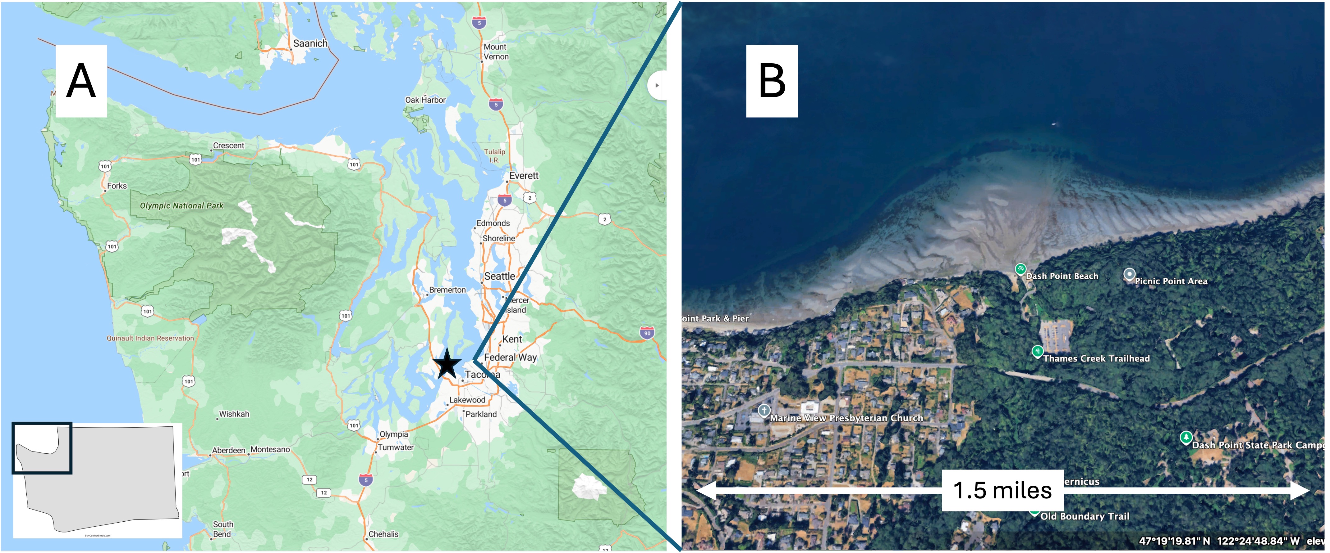
Figure 2. (A) Regional map showing the complex, glacially sculpted, morphology of Puget Sound. The star is approximately where my house is. (B) Google Earth image from about 7000 feet showing Dash Point and the extensive delta being constructed by sediment delivered by a small stream.
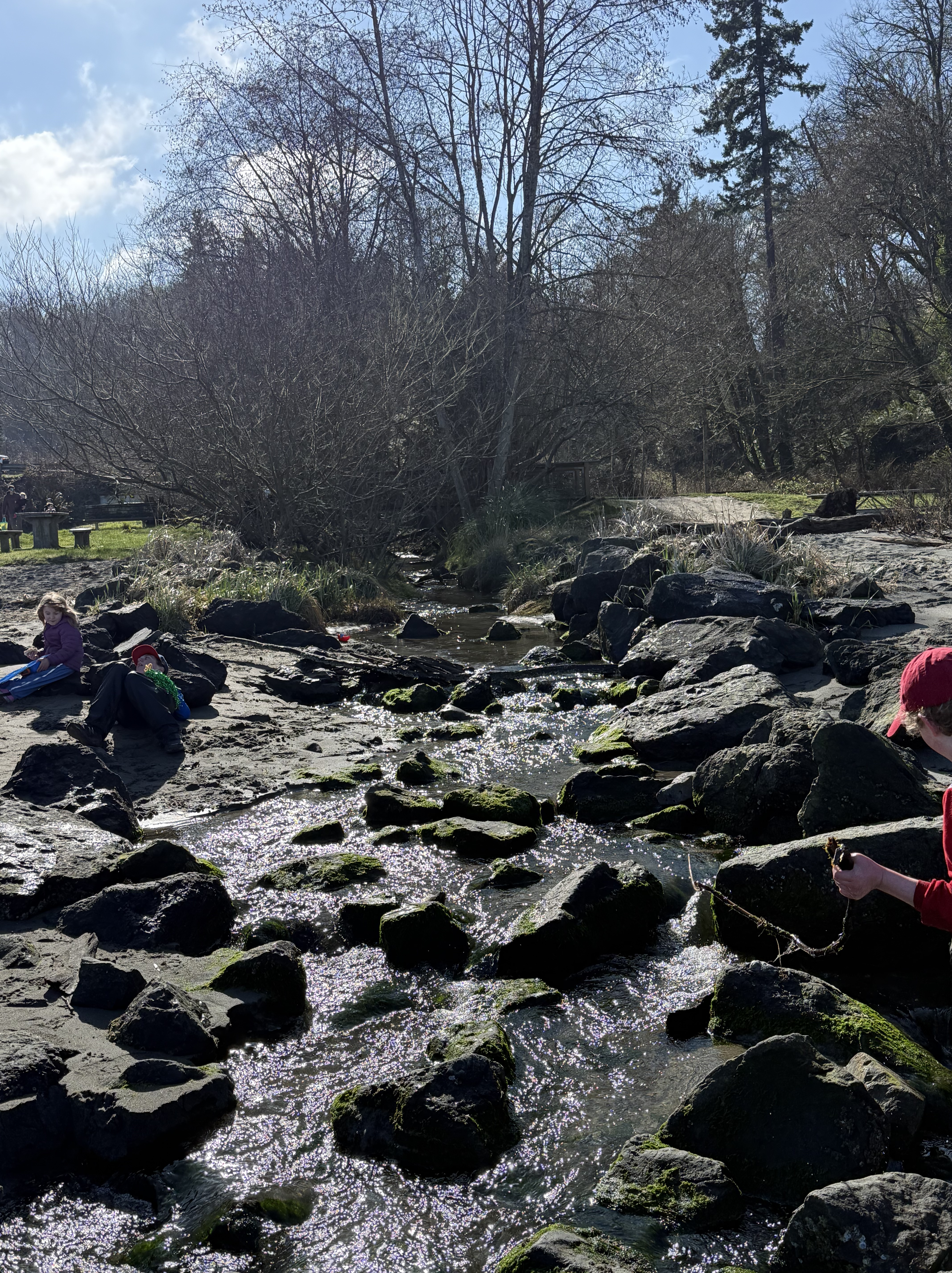
Figure 3. The small stream feeding the delta has been confined to a stone-lined channel. This is the entire inflow. The water looks pretty clear, but appearances can be deceiving in the context of sediment transport. This is a bedload-dominated stream, which means that it is mostly transporting sand and silt, and minimal clay particles. The entire area surrounding Puget Sound is constructed of glacial till, which is mostly gravel and sand. A closer examination will confirm this inference.
Figure 4. This is the delta seen in Fig. 2B during an ebbing tide that is near its minimum. The expanse of the delta, at approximately the same tidal height, is seen here at ground level, revealing tidal channels and swales; but the surface is sand and silt with minimal clay restricted to the swales, like those seen in the middle of this photo.
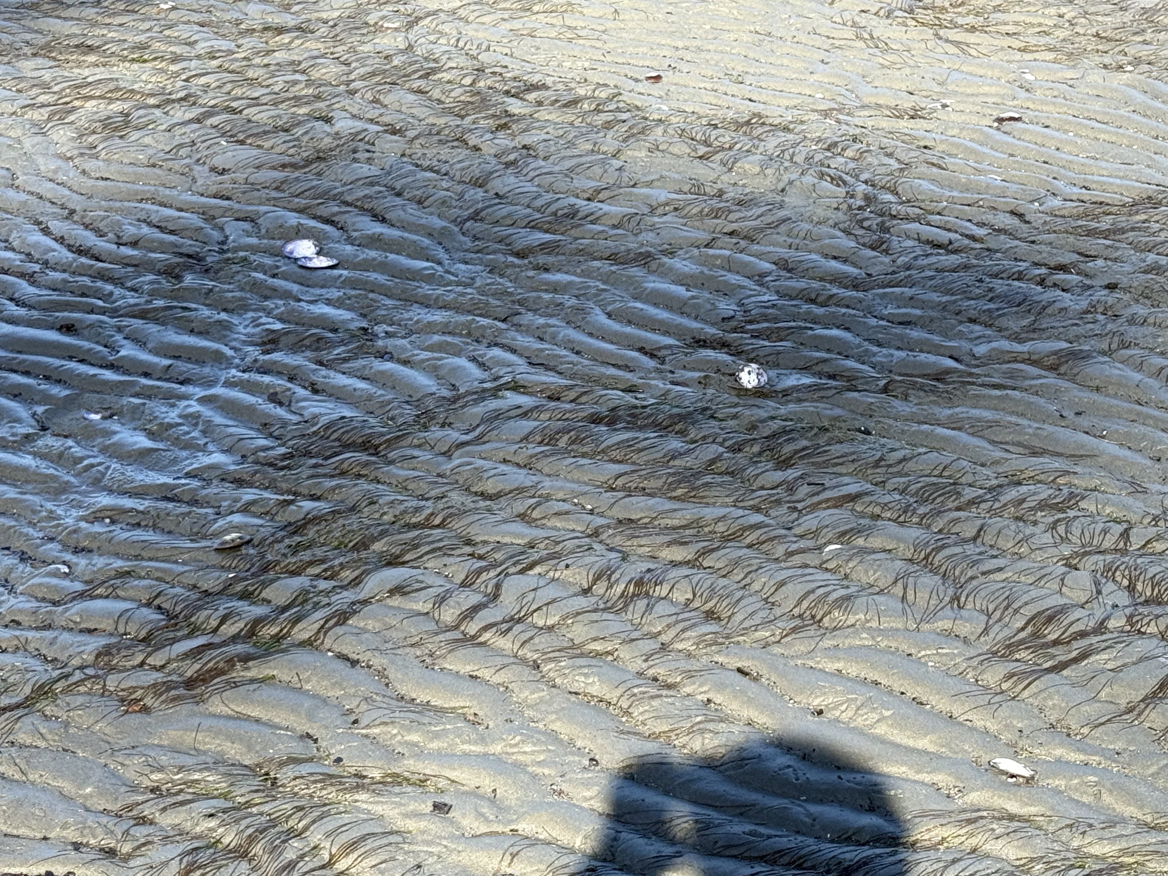
Figure 5. The flattened sea grass serves as a current indicator that perfectly matches the ripple orientation. Note that the tops of the ripples are flattened by the high velocity of the ebbing tide. Waves weren’t very large on this particular day.
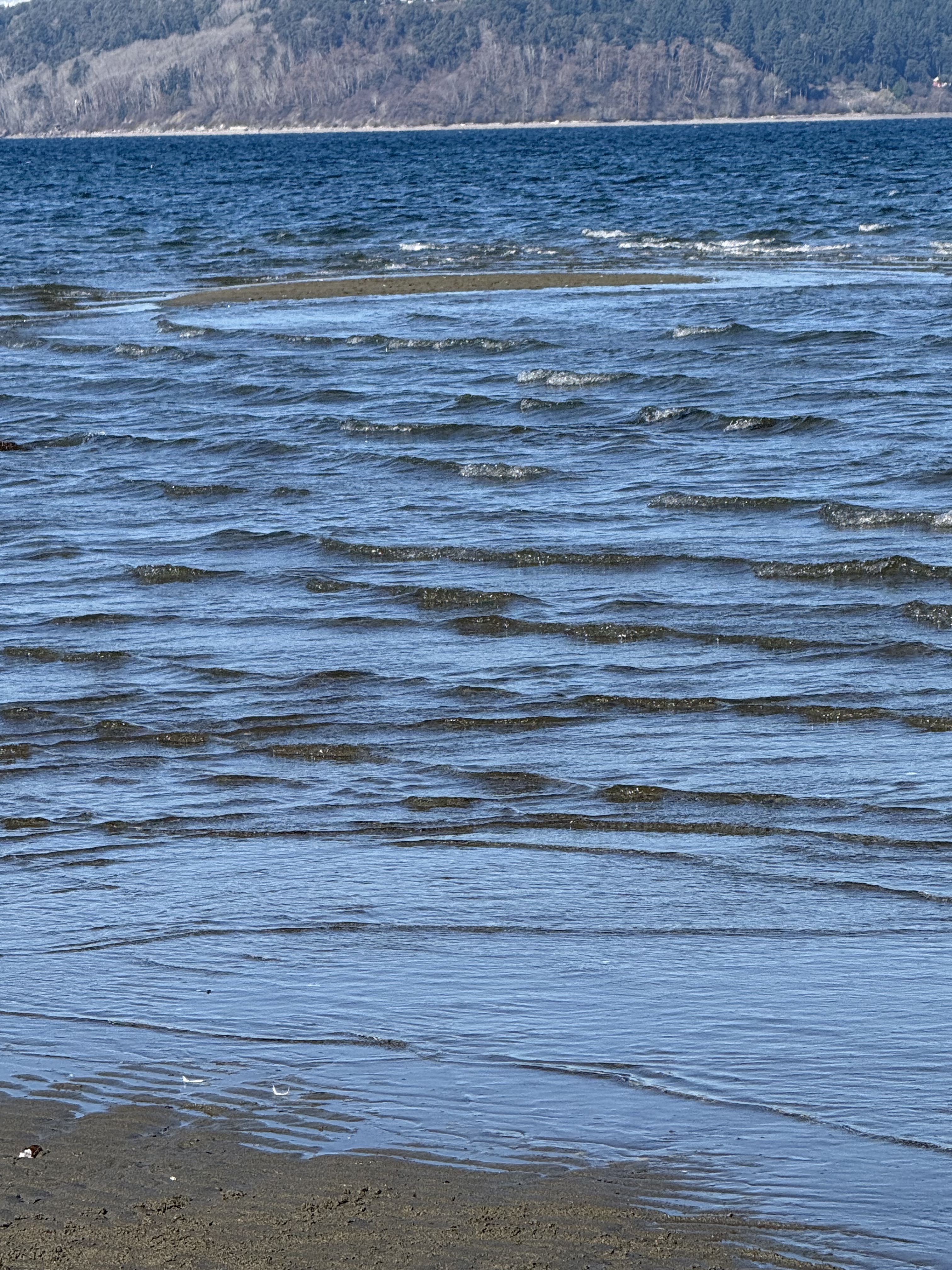
Figure 6. Sand bars are constantly being created and destroyed at the fringe of the delta, probably in seasonal cycles. I don’t know where a late February date fits into this cycle. Perhaps I’ll need to return in the summer.
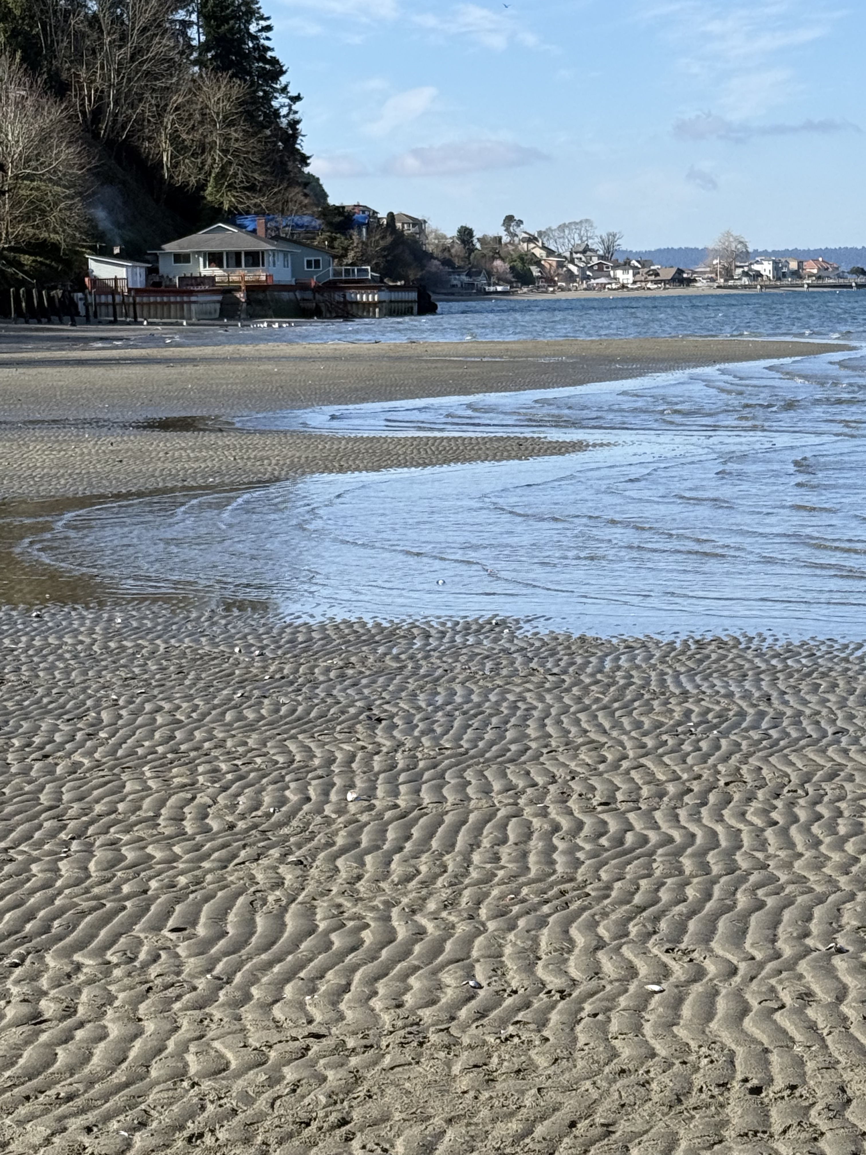
Figure 7. The delta was less symmetric on this February day than the undated image in Fig. 2B. This image looks to the west. It reveals multiple shore-perpendicular sand bars, until the delta is interrupted by shoreline development. Nothing like this was present on the eastern side of the delta on this day. The sediment supplied by the stream in Fig. 3 is being transported westward in this shallow water, but not by waves like we saw on this day, which are perpendicular to the shore.
SUMMARY
Dash Point beach provided a great opportunity to study nearshore sedimentology. Just look at those ripples in Fig. 7! Despite being created and destroyed twice a day, we find rocks preserving similar ripples throughout geologic time.
With so much gravel in the Puget Sound area eroded from the glacial till (gravel and sand), it was exciting to see finer grained sedimentation occurring in real time. Gravel beaches are uncommon in the geologic record whereas rippled, sandy beaches are very common; after all, the previous source of this sand and silt was a glacial till, itself the product of erosion by ice and fluvial transport during the previous twenty-thousand years.
Material is recycled by our tectonically active planet.
Earth abides…
Pinnacle Peak Park: Miocene Andesitic Volcanism
Introduction.
This post examines some of the rocks we discovered while climbing Pinnacle Peak (Fig. 1), a small shield volcano created during the Miocene epoch, between 23 and 5.3 Ma (millions of years ago determined by radiometric dating). The wide range of dates suggests that this volcano remained active for a very long time, producing volcanic material of different types as it released pressure from the magma chamber feeding it. I can’t pin down the dates any better, although they are better known within the geological literature. Thus, my discussion and the model that follows are meant to apply to the entire period of activity.
Figure 1. Pinnacle Peak is about 1000 feet in height. This photo reveals the characteristic low profile of a shield volcano, making it appear smaller because the summit is more than a mile distant; however, note that it is slightly asymmetrical because the southern (right side) slope is lower than the north side.
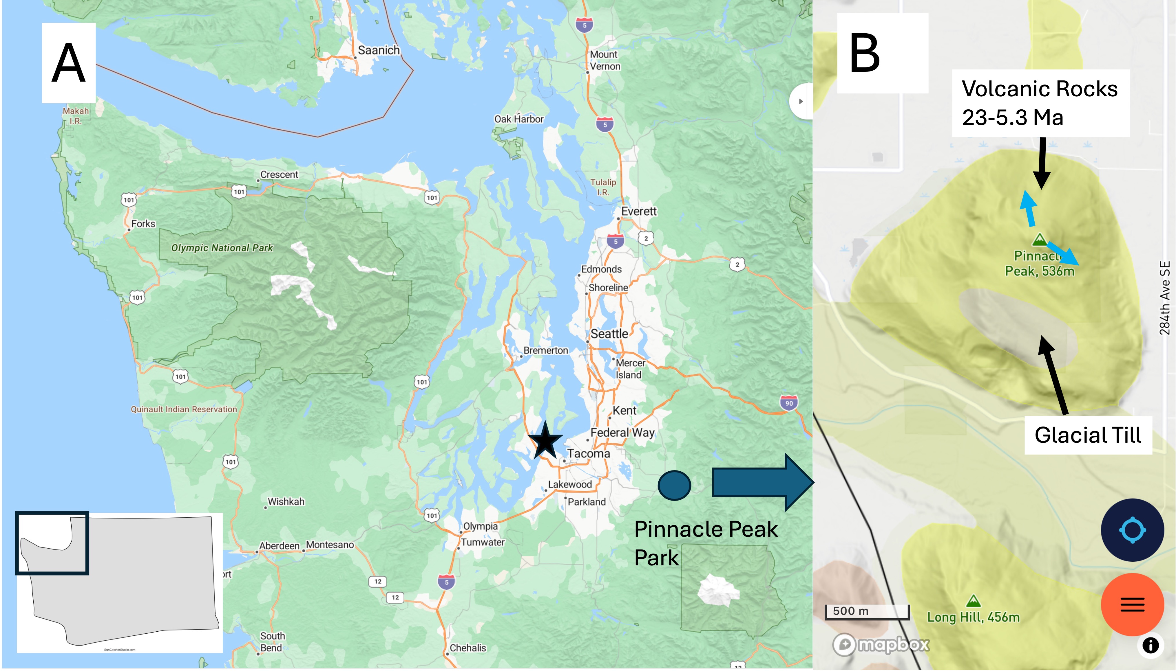
Figure 2. (A) The Pacific Northwest (PNW) base map I will refer to in this series of posts. Tacoma is indicated by a star and Pinnacle Peak park by the circle. It was less than an hour drive on a weekend at 0800; traffic picked up substantially and, by the time we left at about 1130, there was a traffic jam throughout the area because the access roads are small. Go early! (B) The geological map from RockD shows several volcanoes of similar Miocene age standing out in an ocean of glacial till. Note the presence of a deposit of till on the southern slope of the mountain. This was difficult to identify because the main trails followed old logging roads that had been covered with gravel, probably from this till and the White River flood plain below, in which there was active quarrying on the day of our visit. Note the blue arrows at the summit because they will be referred to below.
Observations.
We walked up the Pinnacle Peak Loop Trail counterclockwise, taking photos and noting the geology along the path. However, this is not a geological report but only a casual observation. All dates and rock types are from RockD, a compilation of geological maps produced by uncountable numbers of geologists engaged in active geological field and laboratory research. Thank them for the accessibility of their data, and blame me for any errors in interpreting it.
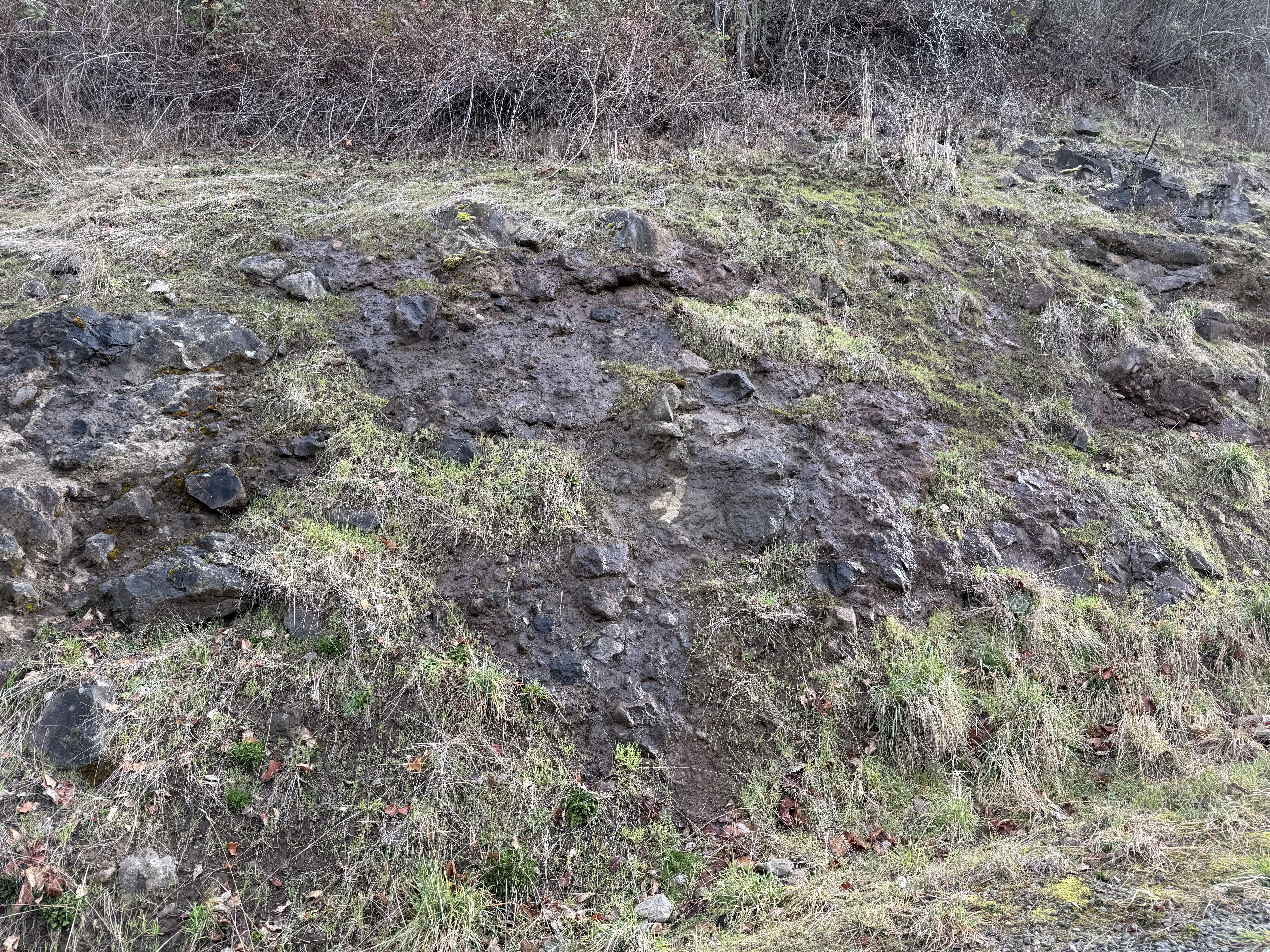
Figure 3. This photo was taken about half-way up the volcano where a road-cut revealed volcaniclastic sediments like we saw at Snoqualmie Falls. This nice exposure reveals a fine matrix of dark material including irregular, but rounded, boulders up to a few feet in diameter. These are volcanic bombs, semi-molten lave blown out of the vent by gas pressure which landed hundreds of feet from the summit.
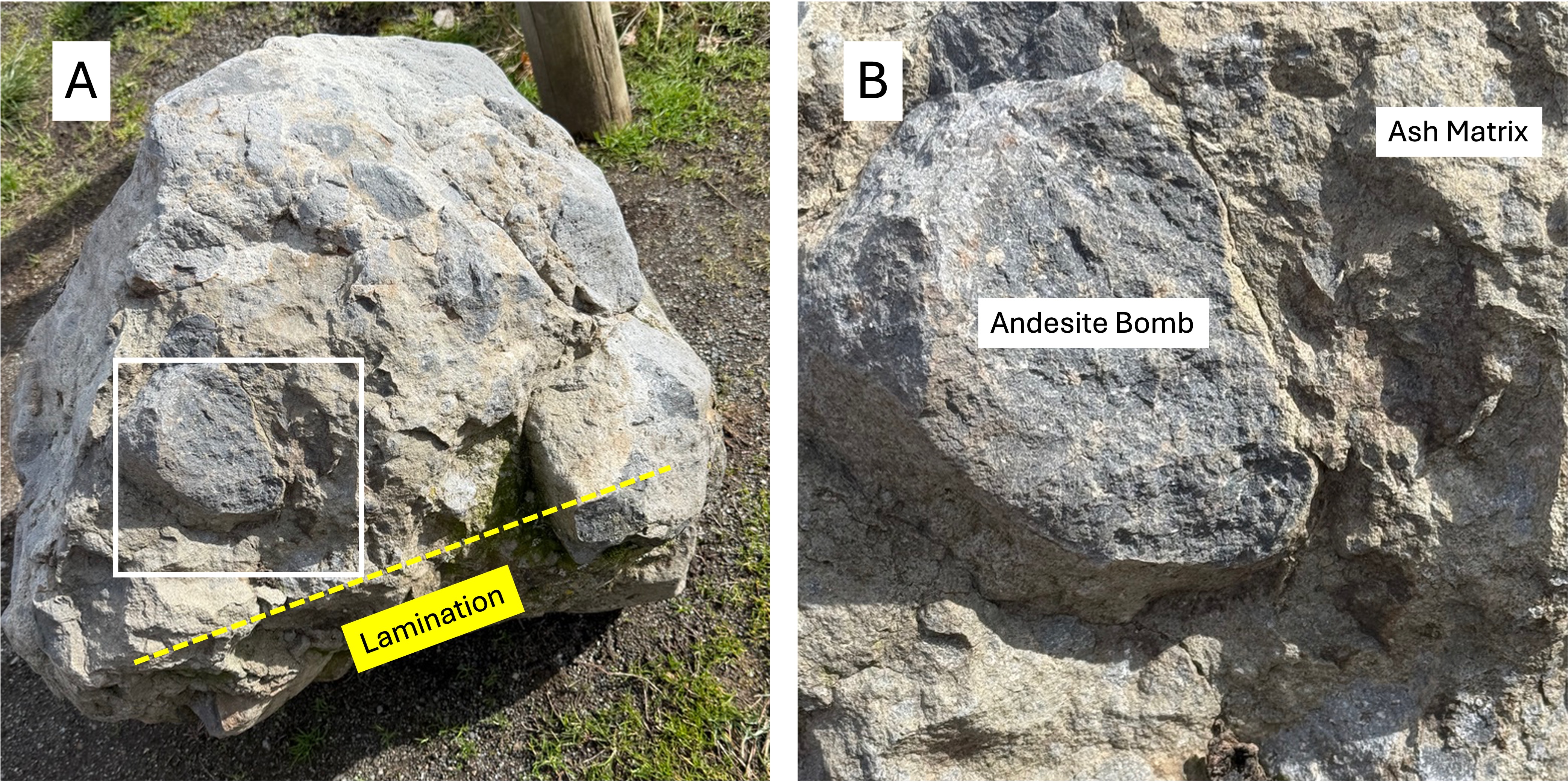
Figure 4. (A) This boulder of volcanic breccia was placed in the parking lot, probably as an example for public viewing. It is about 3 feet in diameter and contains numerous volcanic bombs, as well as fine lamination near what was its original bottom, as labeled in the figure. These would have been layers of ash with alternating chemical properties that gave them different colors. (B) Close-up showing the contrast between the lighter colored ash matrix and an andesite bomb. Imagine this semi-molten, andesite bomb flying hundreds of yards and landing in still-hot ash. The number of bombs visible in (A) suggest that this was part of a very explosive event.
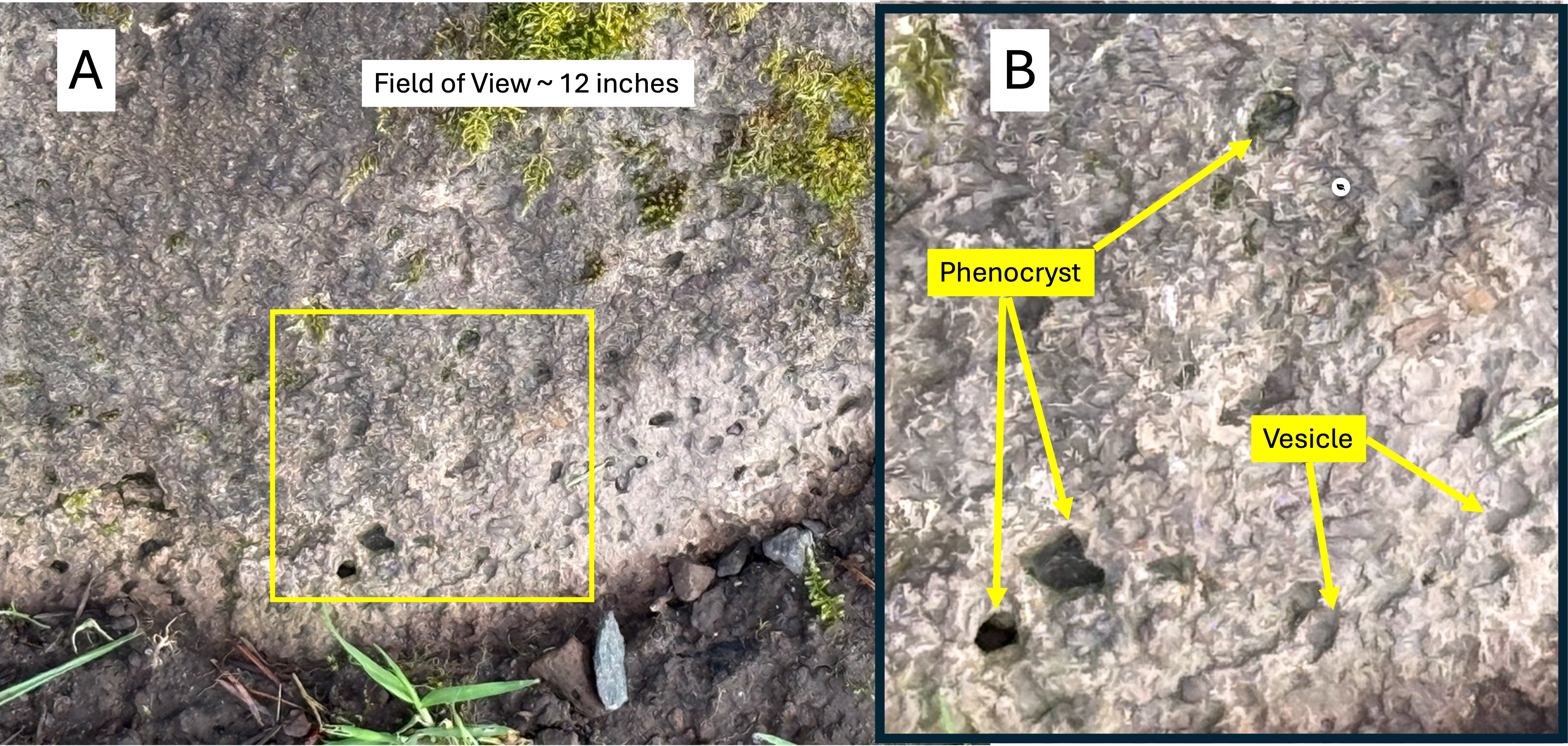
Figure 5. (A) Close-up of a boulder within a semi-hidden exposure of andesite near where Fig. 4 was taken. (B) This close-up reveals phenocrysts (solid mineral crystals) and vesicles (pockets left by escaping volcanic gases). I cannot identify the minerals comprising the phenocrysts, but common ones within andesite are pyroxenes, plagioclase (high-calcium feldspar), hornblende, and biotite. These are all dark minerals that crystallize at higher temperatures than high-silica (Si02) minerals. The specific mineralogy tells volcanologists about the chemistry of the magma chamber feeding the volcano. The vesicles of gas (e.g. CO2, CO, water vapor, sulfur compounds, H2S) are a crude indication of how explosive the magma was; more vesicles implies more explosive potential, especially in andesites, which are more viscous than basalt.
Figure 6. View from near the summit looking south toward the White River. This is a very different perspective of Pinnacle Peak than Fig. 1. The river valley is filled with glacial till (< 1 million years old) that covered all of the volcanic material from the volcano, which stands out today because it was never covered by ice.
Figure 7. Photo taken on the SE side at the top of Pinnacle Peak (blue arrow in Fig. 2A). These horizontal rocks are not boulders, but instead the ends of columnar joint blocks of andesite. They are less than one foot in diameter; most of them are hexagonal, but irregular shapes are also present. They form when lava cools slowly enough to allow this kind of crystallization to occur, but rapidly enough that the lava doesn’t form massive beds.
Figure 8. Photo of columnar andesite near the summit on the NNW side. These are much larger in diameter than those seen in Fig. 7. Columnar jointing is usually oriented with the ends vertical, but this isn’t necessarily required because gravity is not the dominant force; chemical bonds between the individual minerals determines the development and size of columnar joints. As long as the “top” of the lava flow (facing the camera in this photo) is exposed to the atmosphere, they can form. I reported on incredible examples of this in my post on Organ Pipes National Park near Melbourne, Australia.
Figure 9. This exposure, from further down the south slope of Pinnacle Peak, reveals blocky lava that seems to be bedded, with bedding planes dipping away and to the right of the camera. No columnar jointing is visible, and the rocks are solid. This could be an outcrop of sandstone if it weren’t for the grayish color. Maybe limestone?
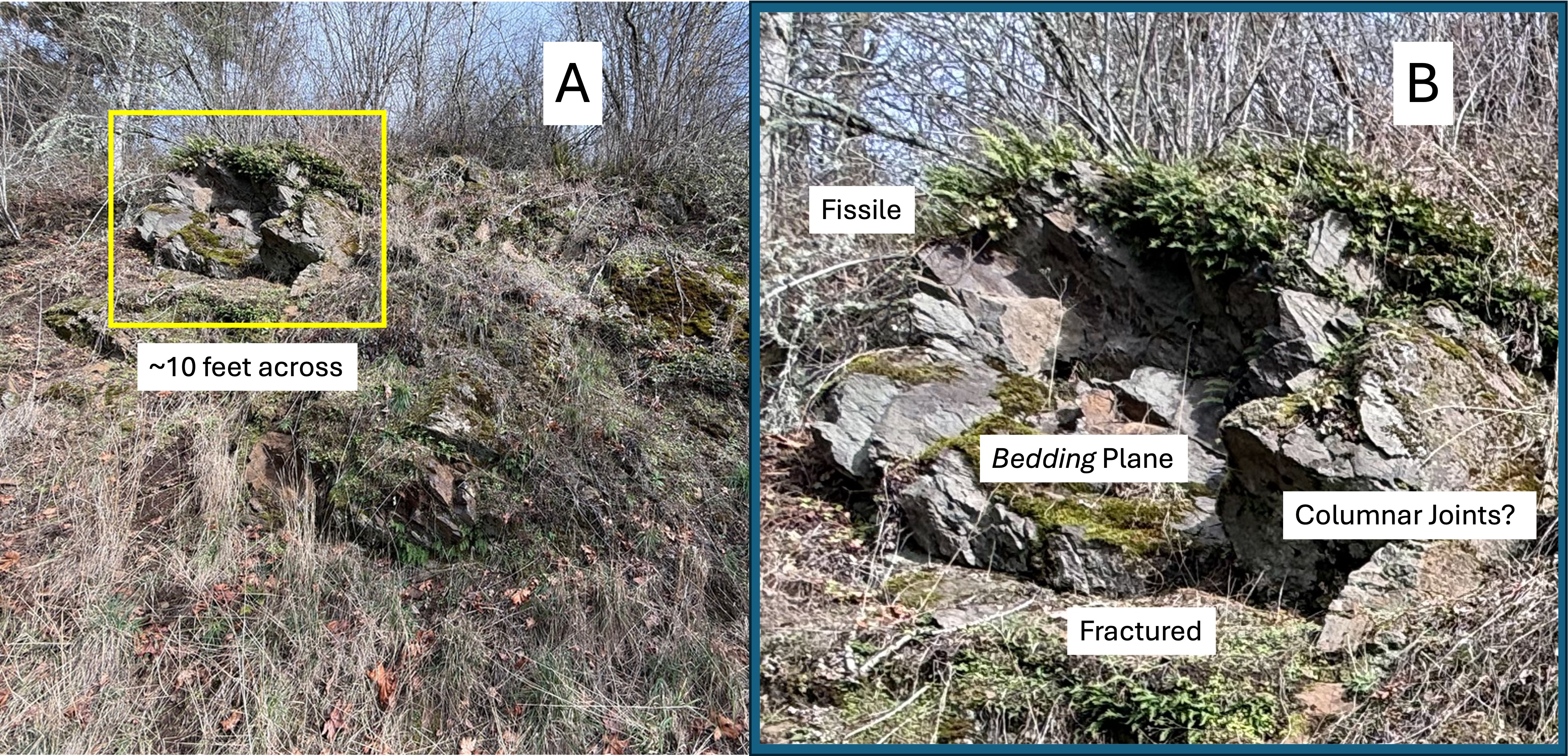
Figure 10. (A) Exposure of andesitic lava that looks much the worse for wear than anything I’ve seen before on this field trip. (B) Close-up of the exposure outlined in (A) that reveals a jumbled mass of lava that reveals several secondary textures: contamination and preferential erosion along “bedding” planes (fissility); irregular and tilted bedding planes; fine-scale fracturing and weathering (fractured); and blocks with a hint of hexagonal form (columnar joints). This was near the bottom of the volcano and the rocks are presumably older than those seen in Figs. 3, 7, 8, and 9; in other words this photo implies that eruption style was not uniform throughout this volcano’s lifetime. I further suggest that, over the lifetime of this volcano’s active period, the magma chamber became more stable, and thus the eruptions more predictable.
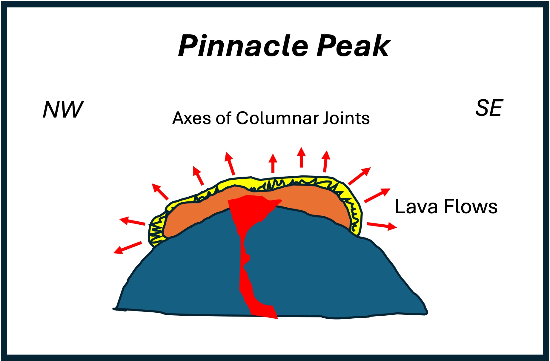
Figure 11. All of the textures, mineralogy, and fabric of the rocks comprising Pinnacle Peak fall within the expected composition of a shield volcano, except for the horizontal columnar jointing seen in Figs. 7 and 8, which point in opposite directions (NW and SE) even though the lava erupted directly from a rather small outlet (~200 feet in diameter). I didn’t understand what I saw at Organ Pipes National Park, but I let it go; now that I’ve encountered similar textures again, I want to have at least a naive understanding of how lava can form structures similar to a wilted plant. This is my model. The purple represents thousands of lava flows, volcaniclastic deposits, etc; the red is the lava just before the eruption(s) represented by Figs. 7 and 8; and the yellow is a thin layer of viscous lava that flowed out over a slightly older deposit. This last eruption wasn’t immediately covered by more lava and it cooled according to the laws of thermodynamics. In other words, it formed columnar joints, which are represented by the squiggly lines. The red arrows point to toward the “top” of the flow at every point; as you can see, the “top” isn’t always pointing towards the sky. This model is based on simple thermodynamics and mineralogy–I assume that the lava is a homogeneous mixture of the components of andesite (e.g. quartz, feldspar, pyroxene), which are cooled only by their exposure to the atmosphere. The different diameters in the columns (compare Figs. 7 and 8) suggests that this is an oversimplification. Nevertheless, it makes sense to me.
SUMMARY.
I had a great time climbing Pinnacle Peak and I learned something new from the rocks that surround and support us. A large mountain range like the Cascades doesn’t appear overnight. Subduction along the NW coast of N. America continued, interrupted by collisions with offshore continents, from 200 Ma to the present, creating multiple mountain ranges which created the Pacific Northwest. A small volcano like Pinnacle Peak would have burned out in a few million years. The range in age is based on stratigraphy, and the absence of funding/geologists to date rocks from every minor volcano in a major subduction zone, leaves me to apply common sense.
Pinnacle Peak erupted about 5 Ma, based on the physical status of the summit. It sputtered for a few hundred-thousand years as the magmatic system decompressed; eventually the magma chamber, or a subsystem of pathways, gave a last gasp. The columnar jointing we saw today suggests that this final eruption consisted of some spitting and then the appearance of timid lava, flowing a few-hundred yards from the summit (Fig. 11). That is what we saw on today’s field trip.
That’s my story…

Recent Comments