
A day’s drive back 330 million years
Today’s post is actually from April 8 but I had to get back to do the necessary reading to make it useful. I drove up on Wednesday before the Mardi Krawl event began to have a fresh start the next day, and took the usual route up I-59 through Mississippi before heading north on US 45 at Meridian, MS. This is a leisurely ride from the coastal plain of Louisiana through the pine hills of SE MS, into the Jackson plain, the north-central hills, Flatwoods, black prairie, and the Tombigbee hills (MS History Now) before crossing into NW Alabama. As these regional names suggest, there is something going on that produced hills and prairies in what we think of as a hilly state. I enjoyed learning at least part of the reason why on this trip.
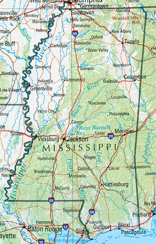
This map of the regions will help in following along. I crossed the Pearl River (still in LA) and immediately began climbing as I drove over Miocene (~23.3 mya) mixed sand and clay sediments on my way to Hattiesburg, MS. The forests were indeed pine woods just like on the coastal plain. There is an unconformity that only careful geologic mapping can identify between these rocks and younger Pliocene (~5.2 mya) sand and gravels. Note that a change from sand and mud to sand and gravel implies that the source of the sediment was closer (i.e. gravel doesn’t travel far in a river). As I approach Laurel, MS, the sediments no longer include gravel.
At this point, my journey through time becomes disjointed because of erosion, which produces unconformities. This erosion results from many processes, including uplift of the crust and changes in climate but I am not going to worry (yet) about that! As I continue traveling up I-59 to the NE, I pass over another missing time period and encounter Oligocene (~35 mya) limestone (somewhat stable ocean) and volcanic ash…volcanism implies uplift usually. Then a lot of sediment is missing when I find myself in Eocene (~56 mya) clay and sand, which suggests a low-energy ocean like the Gulf Coast today. After yet another time interval of erosion, I am driving through older Eocene laminated clay (very calm water) and have a respite from all of this erosion to go back in time to nearshore sandy beaches, until the oldest Eocene sediments are reached after a brief erosional episode…these are fine sands, sandy limestone, and lignite (a burnable organic material, aka brown coal).
I leave I-59 at Meridian, MS, and turn north on US 45, and soon find myself missing time again before driving over Paleocene (~65 mya) sediments containing sand, kaolinite (a pure clay mineral) and clay with bauxite (suggesting a tropical climate…most bauxite today is mined from South America). These (tropical?) sediments are preceded (remember we are going back in time) by clay with sand lenses, like the northern Gulf of Baja, i.e., sand bars on a muddy coast. But then, I drive a little further and a lot of sediment is missing…now I am passing through Cretaceous (~145-66 mya) chalk and chalky sediments. After yet another disruption in my time travel schedule, I am driving over Cretaceous nearshore sediments that include sand, limestone, and chalk (very calm water). At this point I enter Macon, MS, and thankfully drive through slightly older chalk before encountering another missing time interval.
The Cretaceous rocks north of Macon are nearshore sands and clays that suggest tides and waves (e.g., the east coast with its bays and mudflats). Then I arrive in Columbus, MS, and see these nearshore rocks for a while before smoothly passing into clay, then sand, and then gravel before hitting another unconformity. I crossed the AL state line about now and these (fairly) uniform sediments are replaced by Mississippian (~360-320 mya) sediments…I am in NW AL and a more continuous (although older) time interval.
I am not qualified to reconstruct the geography of Mississippi during this ~320 my (million year) interval but I will try anyway because this is not the real reason for my road trip…to go wheeling! I will start at the oldest rocks I encountered in MS/AL, the Mississippian limestones and nearshore sediments. This was an environment not too different from the U.S. east coast today. The missing 175 million years were caused by the erosion of the ancestral southern Appalachian Mtns, when Africa said HELLO to N. America. These mountains must have been huge, like the Himalayas today and not continuous like the Andes, which resulted in different erosion/sedimentation at every location along their front (towards the central U.S.). Eventually, they wore down enough that the erosional products (i.e. sand and gravel) were not themselves eroded. These sediments are seen near the MS/AL border near Smithville, MS.
A stable ocean (i.e. marine) environment did occur and was preserved in the nearshore sediments near Columbus, MS. All the while there were changes in sea level and adjustments in the earth’s crust that led to periodic episodes of erosion, resulting in some of the observed unconformities. The presence of chalk, which results from the quiet accumulation of algae-like plants, indicates stability for long periods of time. In the late Cretaceous, however, there was an uninterrupted shoaling of water depth and a coastal ocean returned (for a while). The sediments then oscillated between these coastal sands and limestones and land-based sediments like lignite and bauxite. All this time the land-mass was shifting northward from the equatorial climate indicated by the bauxites in the Eocene.
Just when all seems set, volcanism began (bentonites are the clays that come from ash layers) even while a quiet ocean was present in MS, as indicated by the limestones near Meridian, MS in Oligocene time. The presence of land-based (i.e. terrestrial) sediments in SW MS during later Eocene (~40 mya?) suggests that equilibrium was approaching this area. The large number of unconformities, however, indicates that erosion was still in charge, as it is today along the entire southern Appalachian Mountains and their descendent plateaus, like the one I will be visiting.
I would like to relate these geologic episodes and their resulting sediments to the geographic provinces identified in MS. This is a difficult task but I will try from the oldest (i.e. NE MS) to the youngest (SW MS). This can be easily accomplished by overlaying the MS geologic map on the geographic province map using GIS software, which I don’t have. The Tombigbee Hills are coincident with the Cretaceous nearshore sediments near Smithville, MS; sands resist erosion better than clays. The Black Prairie is consistent (a wishy-washy scientific word) with the unconformity just SW of Columbus, MS, and that would also explain the Pontotoc Ridge because a pure sandstone layer (like the nearshore sands of late Cretaceous) would be resistant to erosion. Chalk doesn’t weather well and a layer like that between Macon and Columbus would result in a flatter landscape like the Flatwoods.
The North Central Hills province is consistent with irregular erosion of mixed sandy-muddy sediments like those between Macon and Meridian (Paleocene) whereas the Jackson Prairie could be the result of erosion of the mostly muddy sediments (and volcanics, which erode rapidly) that were deposited during the Eocene between Meridian and Laurel, MS. The Pine Hills are another product from irregular (aka heterogeneous) erosion of sandy sediments.
And of course we shouldn’t forget that the earth’s crust is sinking along the Mississippi River for uncertain reasons, causing all of these layers of sediment to dip to the west. You can see my previous post about this.

Trackbacks / Pingbacks