
Ecosystem Notes from Quinault Rainforest
Introduction
I’ve spent the past few months wandering the Olympic Peninsula with my attention fixed mostly on rocks—tilted beds, breccias, sea stacks, and the stories they tell about deep time. But along the way I’ve been noticing the living world with the same quiet fascination. I’m not a biologist and I don’t pretend to be; I can’t name any of the plants I pass. What I can see is how each organism plays a role in the larger system, the way geology shapes life and life responds in turn. These are simply notes from a wanderer paying closer attention.
I’ll try to remember to label these environmental posts as NOTES to avoid any confusion, especially on my part. This first post arises from a short walk on a semi-muddy trail through the Quinault Rainforest, on the Olympic Peninsula. I won’t have much to say about the photos, and all identification will come from CoPilot (aka ChatGPT). I’m certain its identifications will be better than mine after hours of searching the internet.
Quinault Rainforest in Olympic National Park
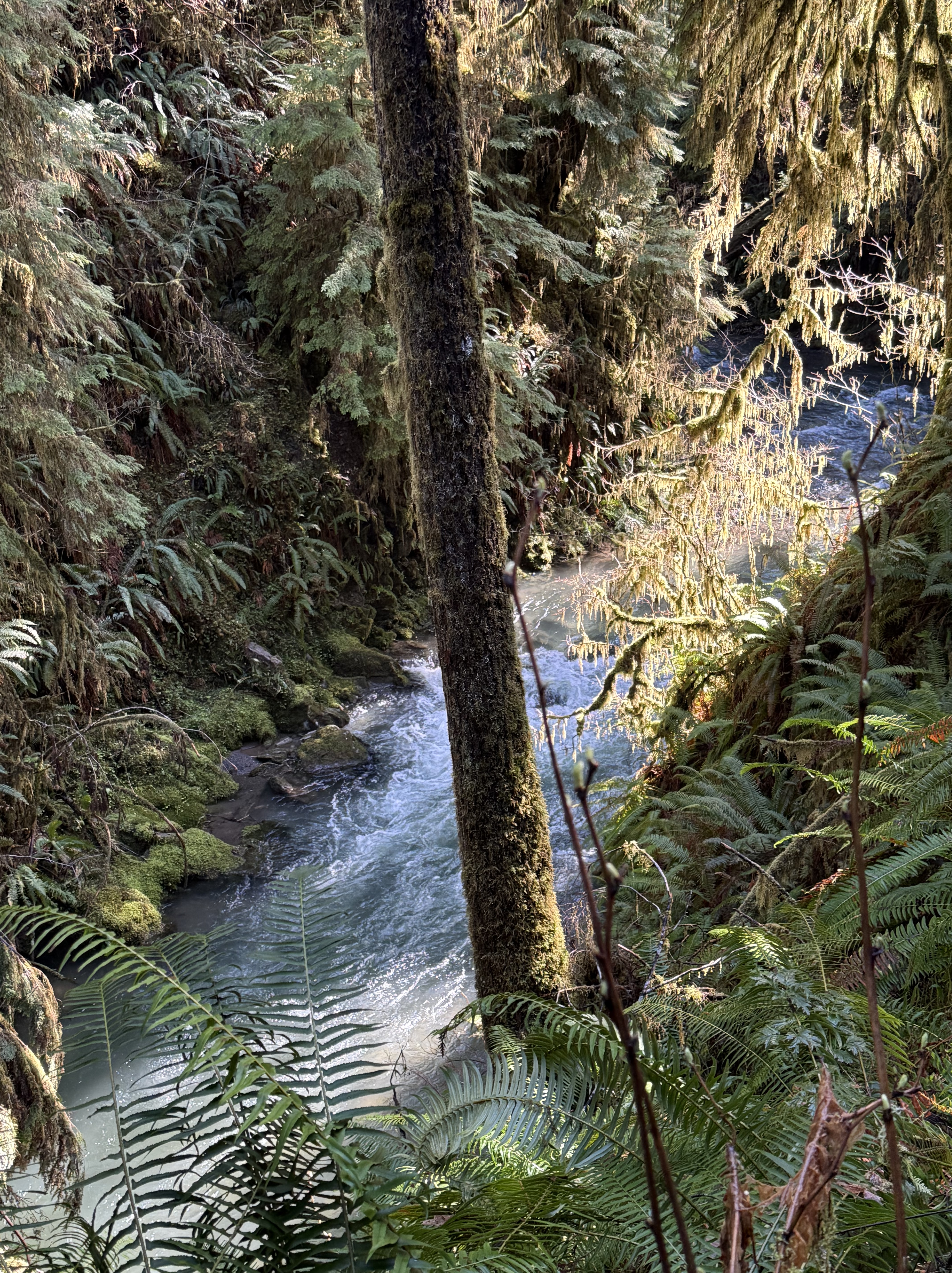
Plate 1. That raging stream about 50 feet below me is one of hundreds draining this temperate rainforest, which gets about 12 feet of rain per year. Note the ferns, which are everywhere, even in the temperate forests of northern Virginia. Ferns must be the most common plant in cooler forests. I am in a narrow strand of Olympic National Park that has never been logged. This is primordial nature, viewed by a geologist, but I’ll do my best.
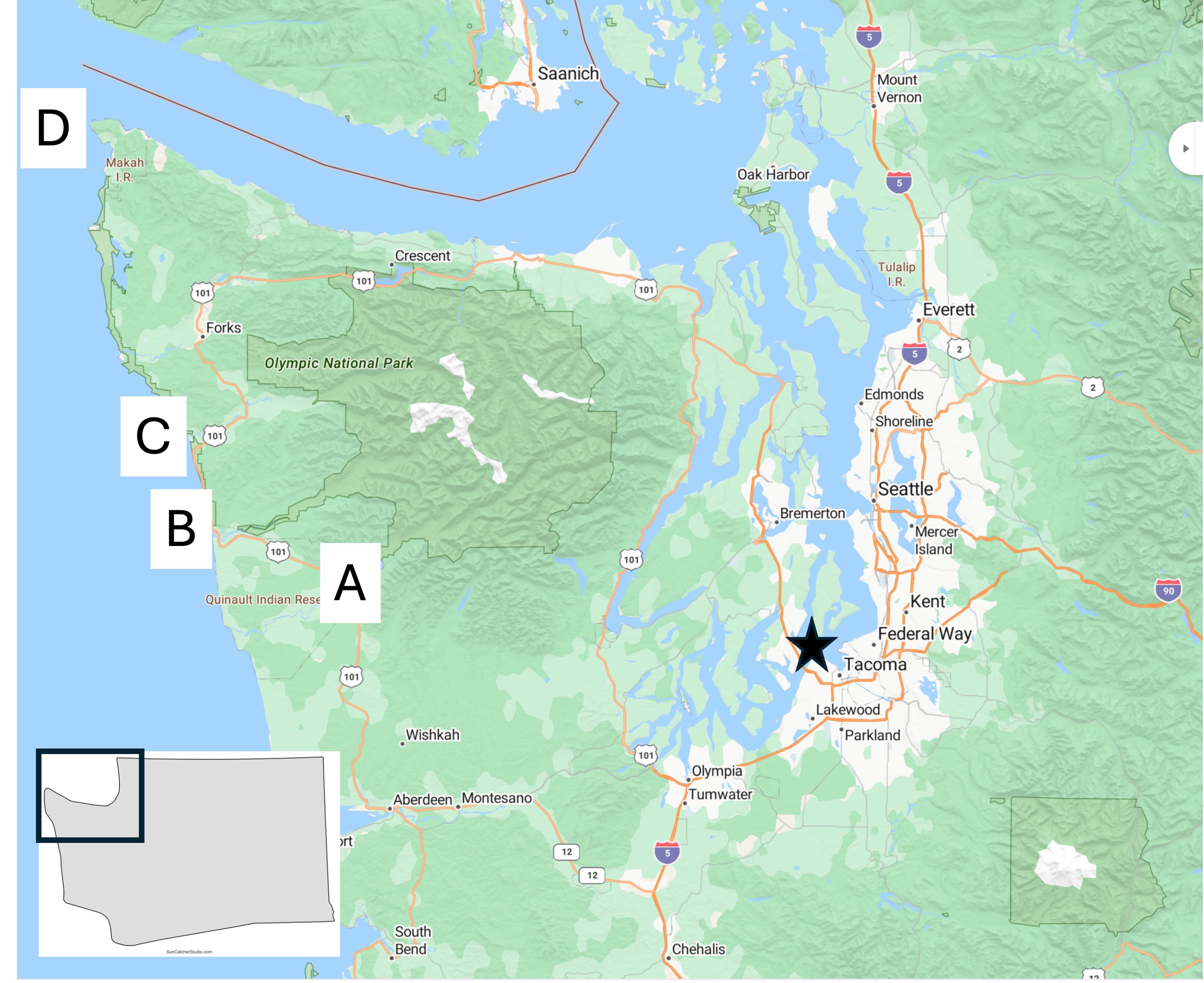
Plate 2. Map of the Olympic Peninsula showing the areas I reported on in previous posts. I’m going to be focusing on Site A today, with a few photos from D.
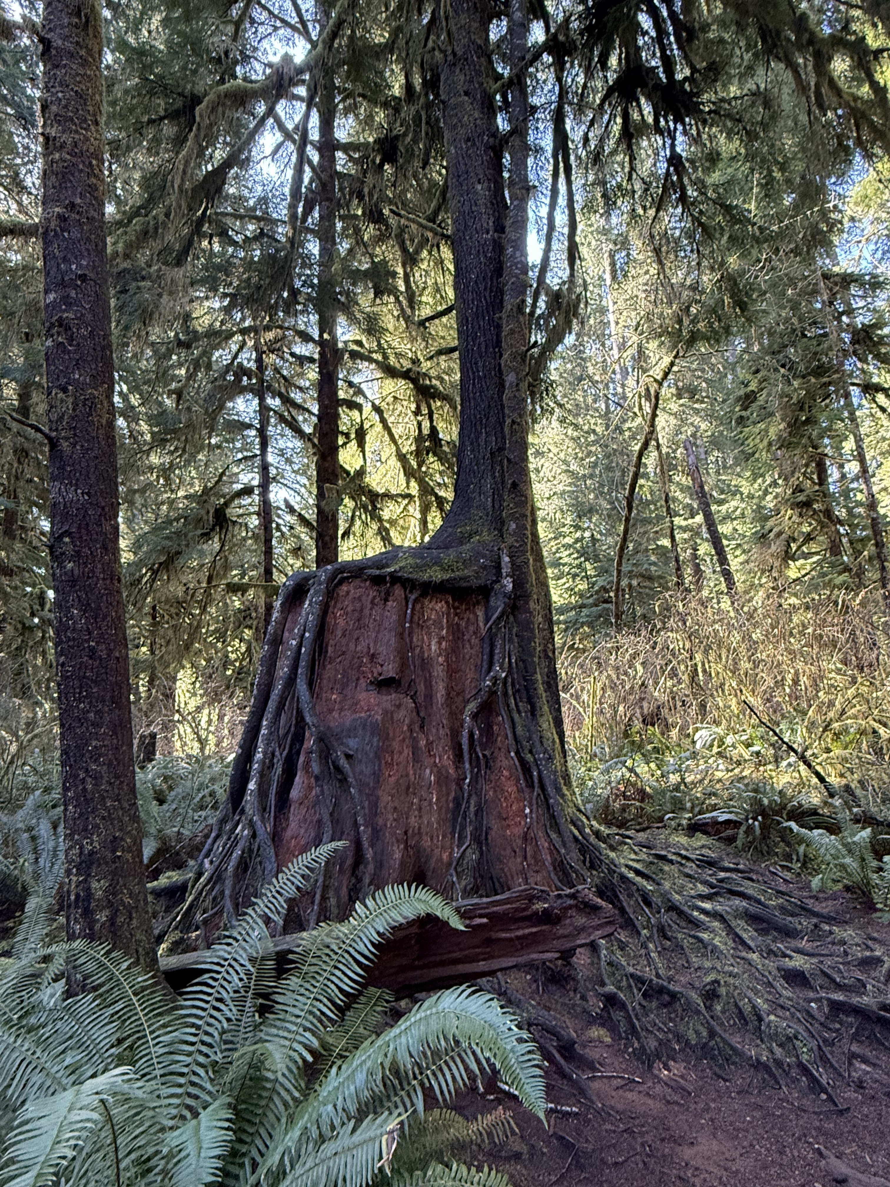
Plate 3. I haven’t seen this anywhere else I’ve lived, not even northern Virginia, but they occur everywhere here in Washington. Apparently this is a common occurrence in rainforests, where the ground is a dangerous place for seeds. I couldn’t identify the species in this photo, but this practice is very common for hemlock.
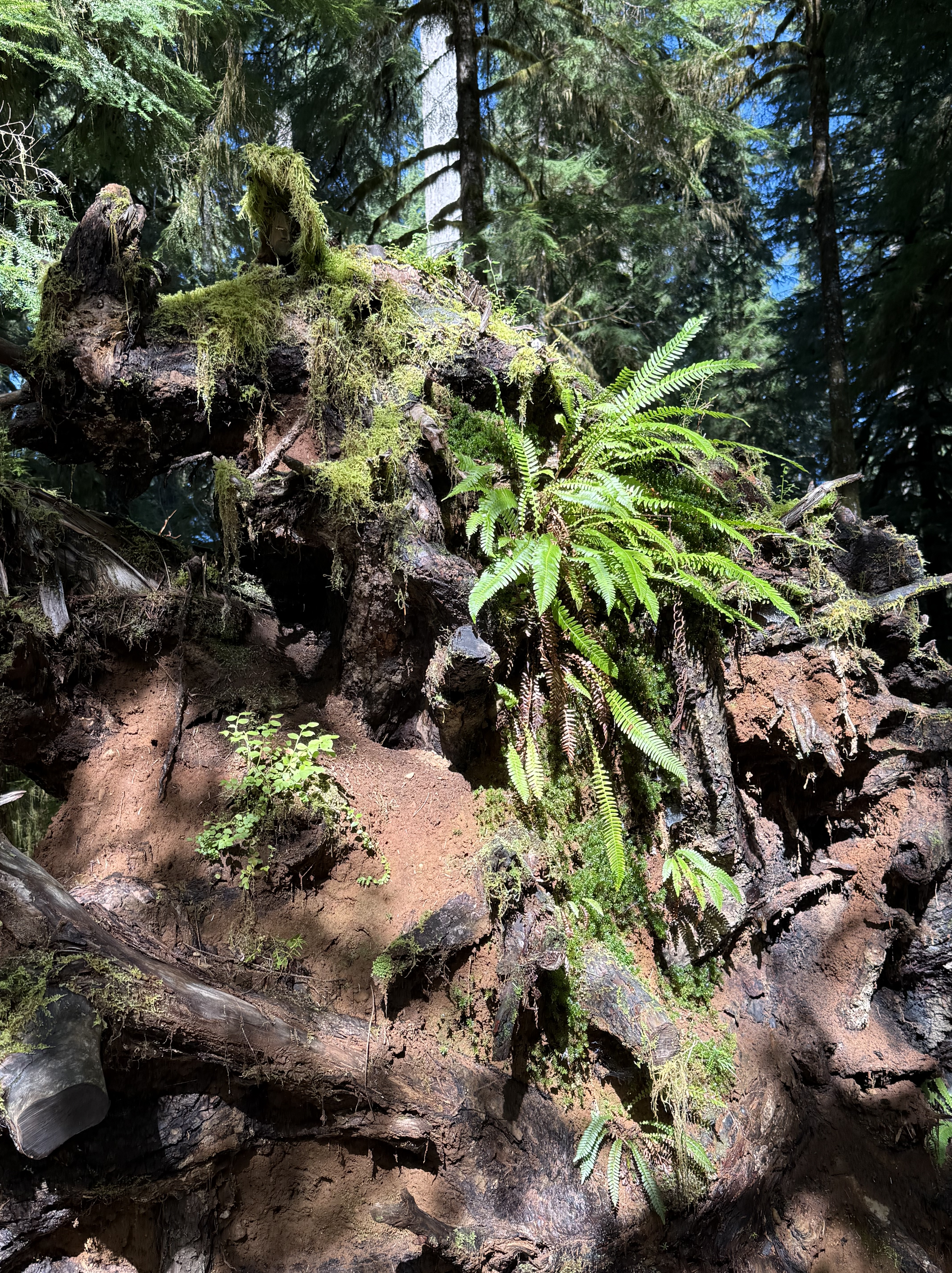
Plate 4. This pile of debris is a large log turning into compost and supplying nutrients to a variety of plants. The top of the photo shows the base of a young tree growing out of all this chaos. According to CoPilot and the Olympic National Park map, this area has never been logged, so I am in wonder of this pile of “forest garbage”. Is that sandy soil I see? Where did it come from? I don’t know.
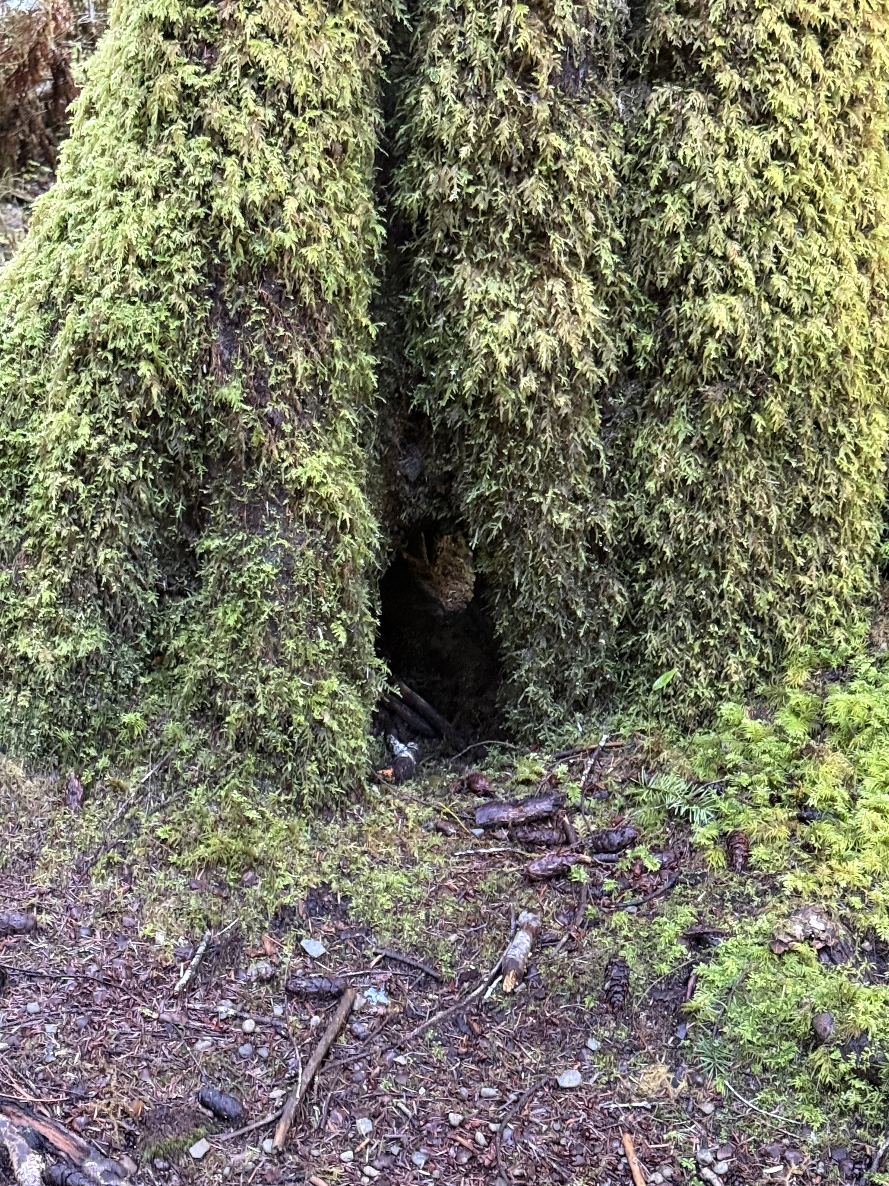
Plate 5. If you look close in the exact center of this photo, you’ll see daylight on the other side of the base of this unidentified tree. It’s about six-feet in diameter and covered with an epiphyte community of mosses and liverworts. Those aren’t leaves or fronds, but communities that mimic ferns–for their own reasons.
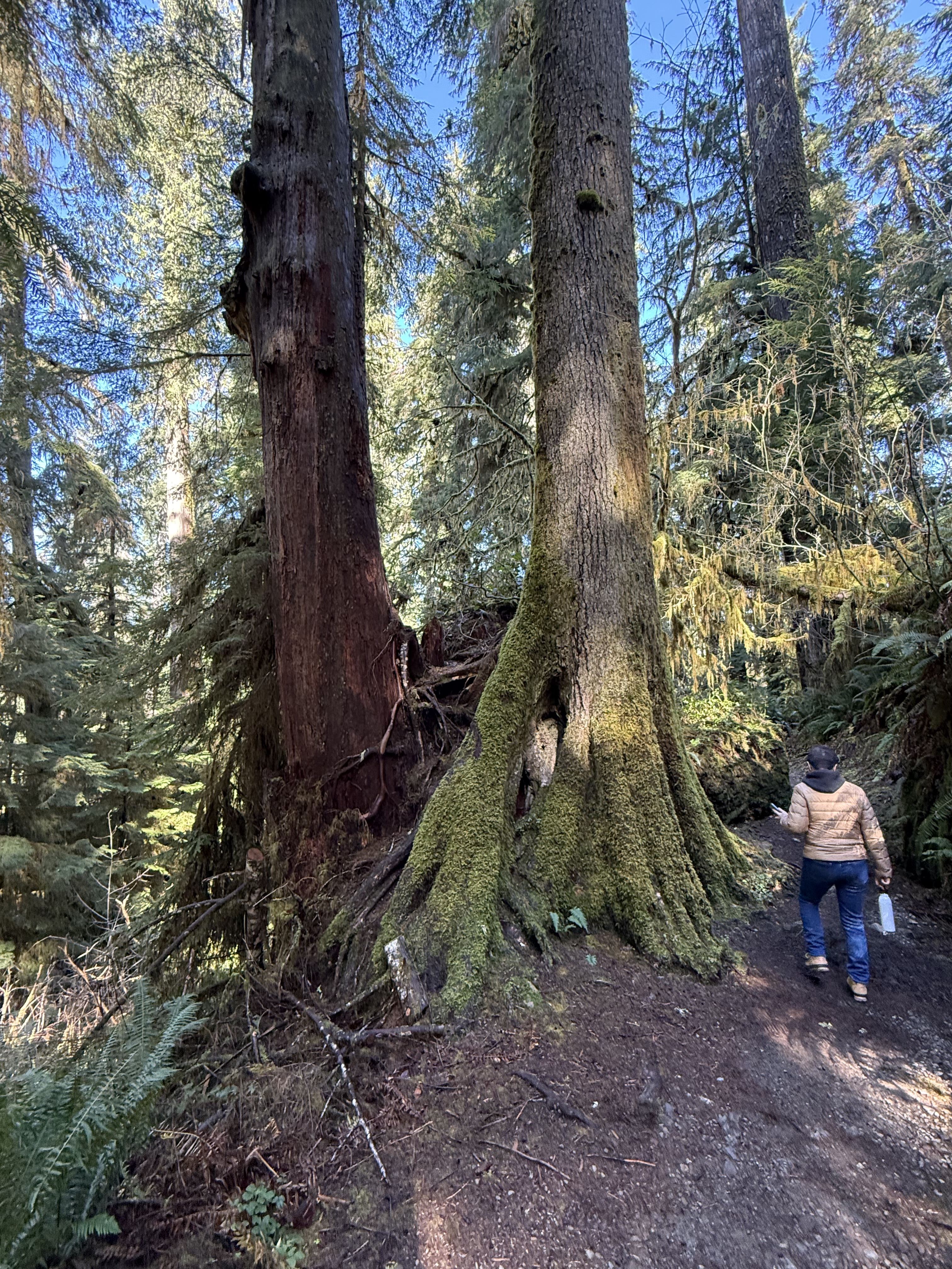
Plate 6. Here’s an example of a Western Red Cedar that has grown into a mature tree after being nursed by a stump. I guess it will eventually absorb the rotting stump and grow to full height, but this is the largest I’ve seen so far in the region.
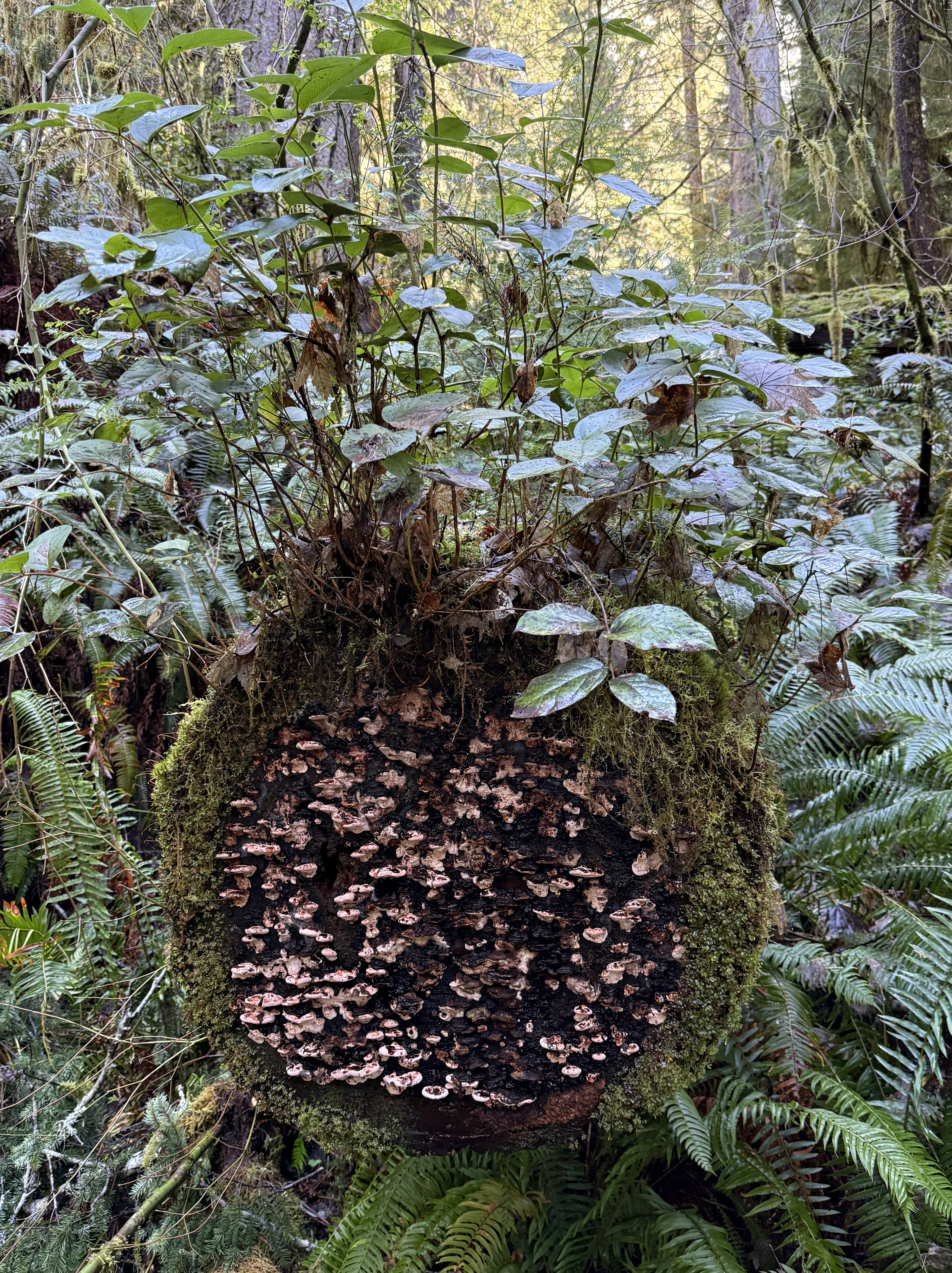
Plate 6. This miniature ecosystem caught my eye, but I had to turn to CoPilot to get an idea of what’s going on. As a tree trunk decays it goes through five stages: 1) moss; 2) liverworts; 3) fungi; 4) shrubs; and 5) young trees. This one seems to be in stages 1-4. I didn’t see any seedlings on it. The shrub is probably huckleberry and the mushrooms a bracket fungus, probably Trametes or Stereum.
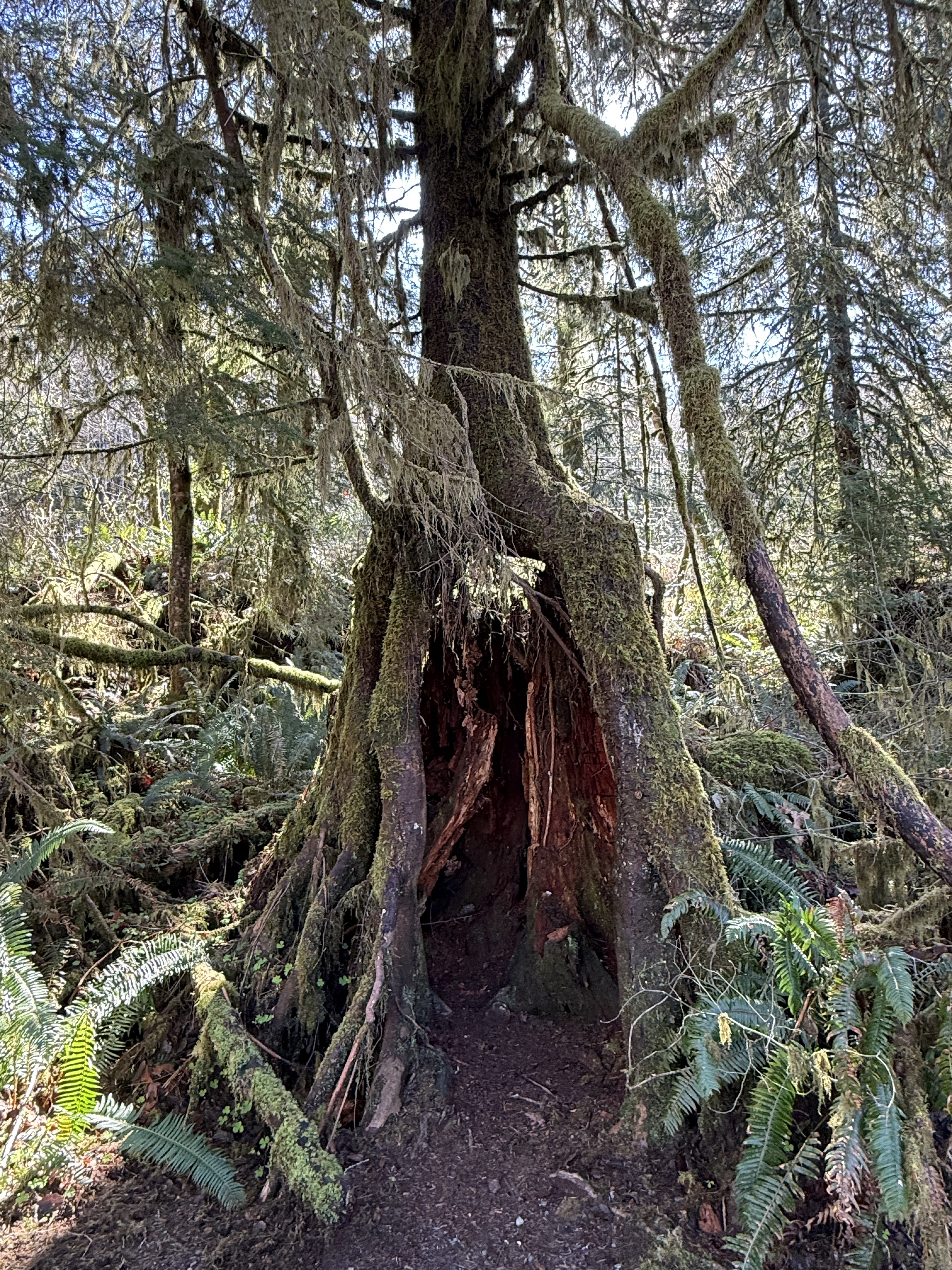
Plate 7. I am fascinated by these nurse trees after seeing species of fig trees in Australia that devour living trees, like a giant fungus or alien. These are nursing on dead trees, however, so it isn’t as gross; but this one is now standing on its own legs after the original stump has begun to collapse.
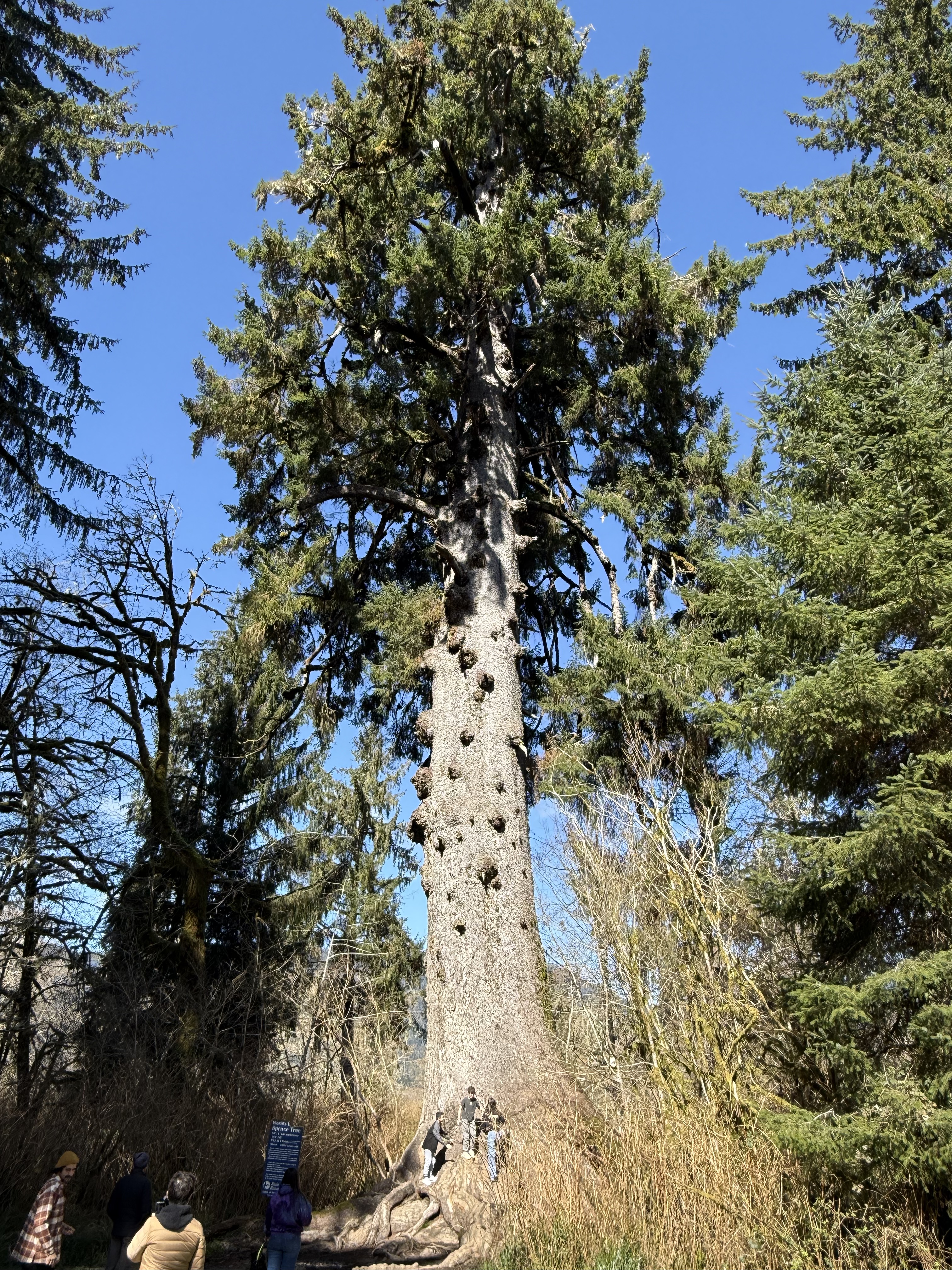
Plate 8. This is the largest Spruce tree in the world. It’s 191 feet tall and about 1000 years old. It is growing in a swampy wet land at the inflowing stream to a glacial lake, Lake Quinault.
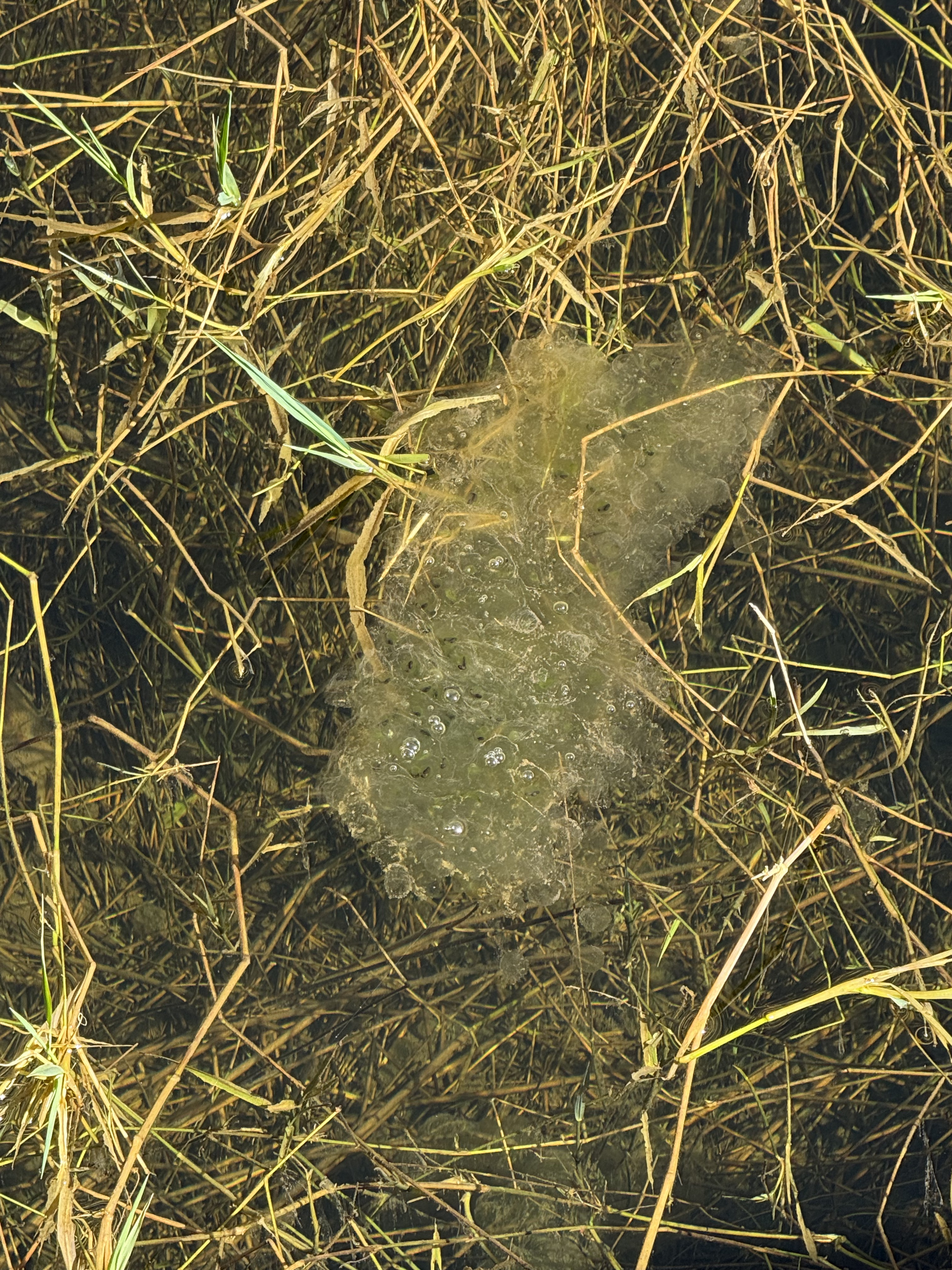
Plate 9. I thought this was toxic waste until CoPilot took a look at the photo: this is a mass of frog eggs (probably northern red-legged frog). There were several more at the shallow, marshy wetland where a stream fed Lake Quinault. The water is so clear you can see the bottom, which is only a couple of feet down.
Kalaloch Beach in Olympic National Park
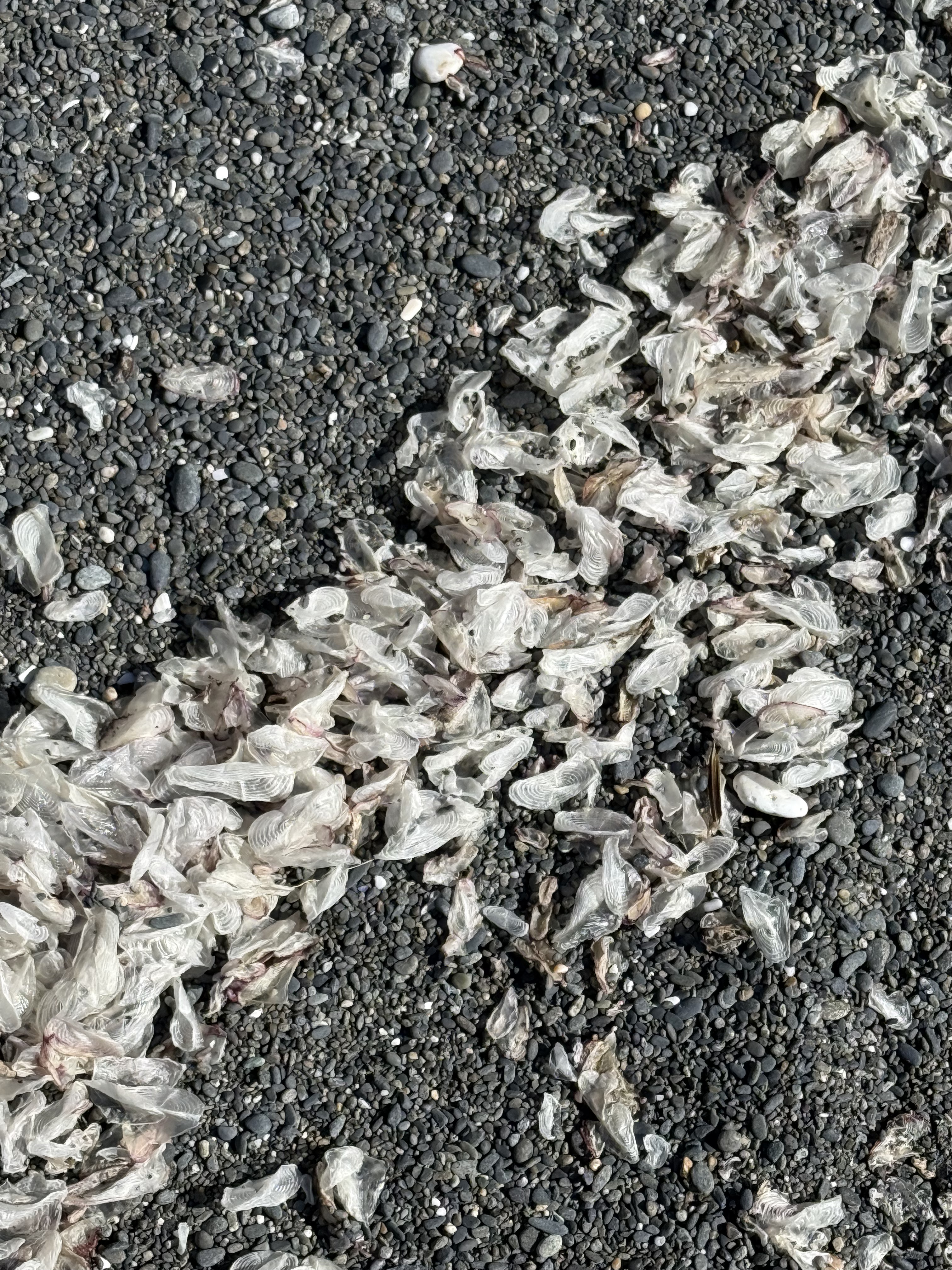
Plate 10. This one was a doozy. These objects are one-two inches long, thin, translucent, and oval in general shape. At first, CoPilot suggested insect wings (until I told it the size), then gull secondary feathers (until I said, “no way”), then settled on small fish cranial bones–e.g. the opercula, the bone that covers the gill. I asked for references, but it supplied me with titles and no links (how did it find them?). I spent longer on this photo than I wanted to. I don’t fault CoPilot for its ambiguous response because I found nothing when I looked very specifically. This phenomenon is either so common that no one bothers mentioning it, or infrequently observed that no serious beachcombers have stumbled across it. I’m going to have to agree (for now) with CoPilot that these are small bones from a school of fish that was decimated by either predation, coastal fishing, or disease and only these translucent cranial bones survived by floating, until waves concentrated them on this beach. This is the only beach where I saw them. I guess there are no easy answers to some questions–unless someone who reads this is a marine biologist.
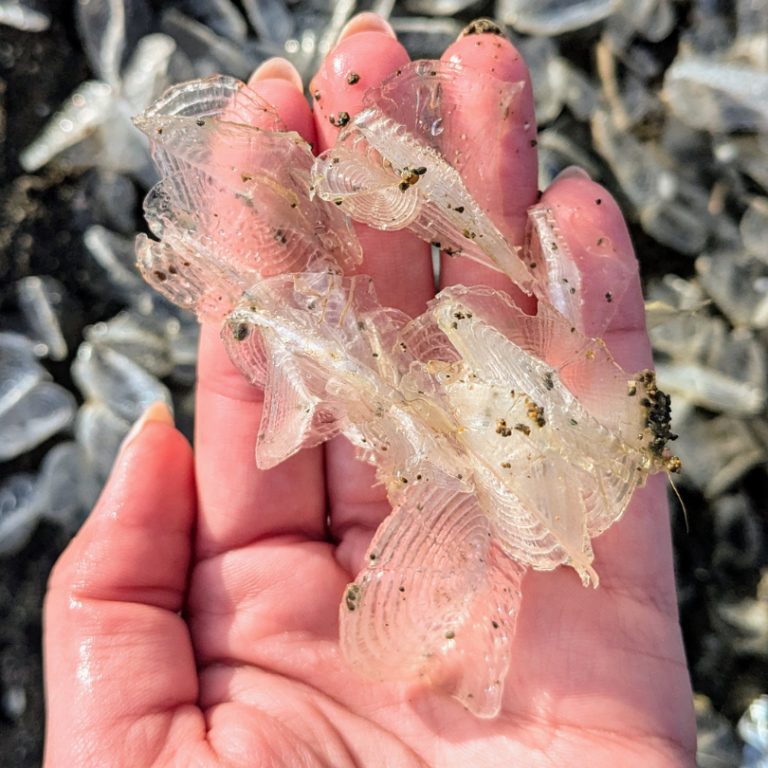
Plate 11. I solved the mystery of the white objects on the beach (Plate 10). I spoke to an ecologist I know who suggested they are a Hydrozoa called Velella-velella, which floats on the ocean like a jellyfish. They are a colonial organism that is blown about by the wind. They don’t swim so they are easily blown onto a beach and carried by waves. (Here’s a good article about them.)
Cape Flattery
I reported on this amazing location in a previous post. You can scan that post to get an idea of where these photos were taken.
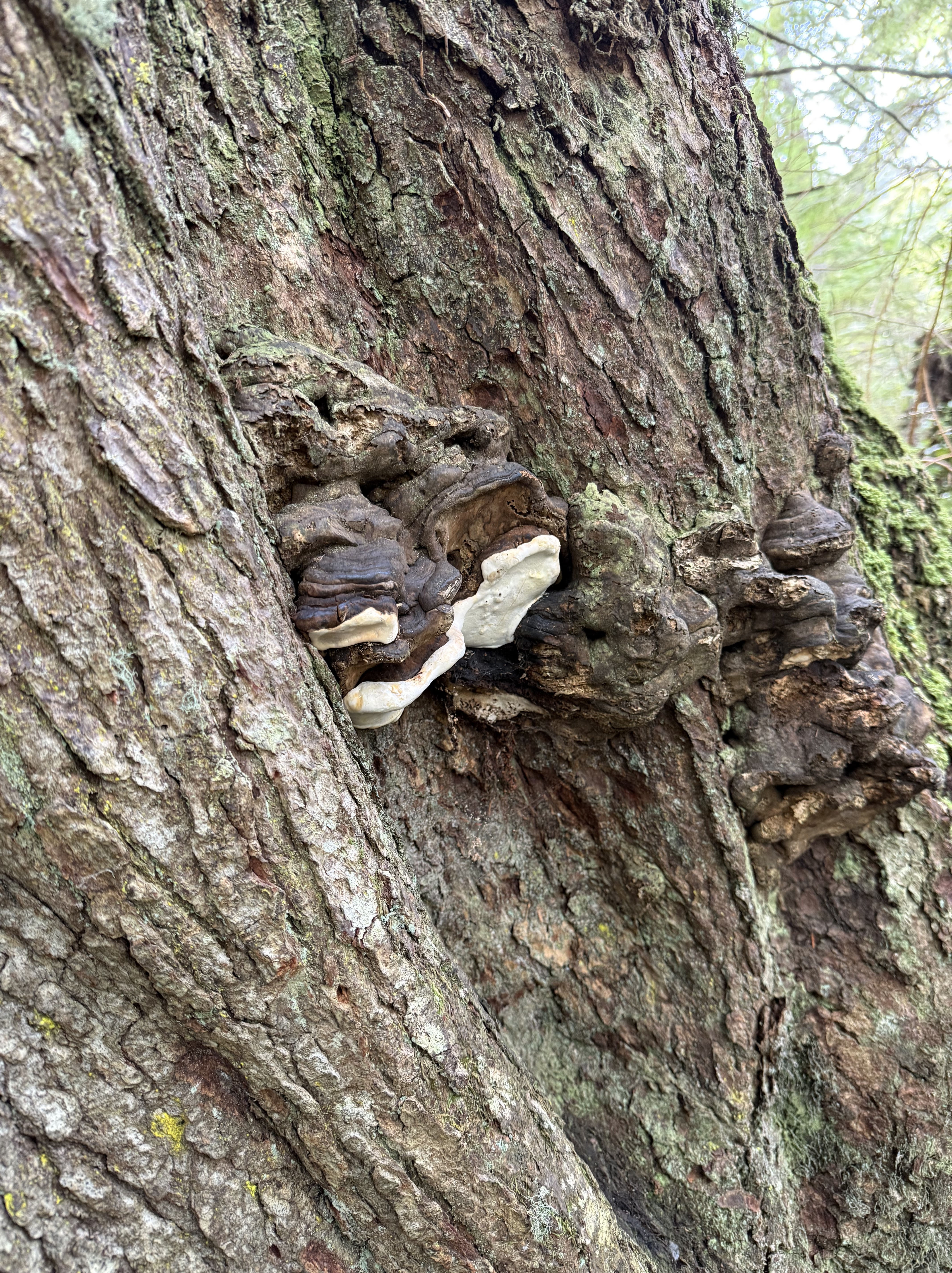
Plate 11. I don’t know if this living (it looked healthy to me) tree was stressed or not, but CoPilot thinks these are perennial bracket fungi, which favor environmentally stressed conifers. There were only a few on this tree. I noticed that this forest didn’t show nearly as many signs of decay as Quinault Rainforest, despite its exposed location.
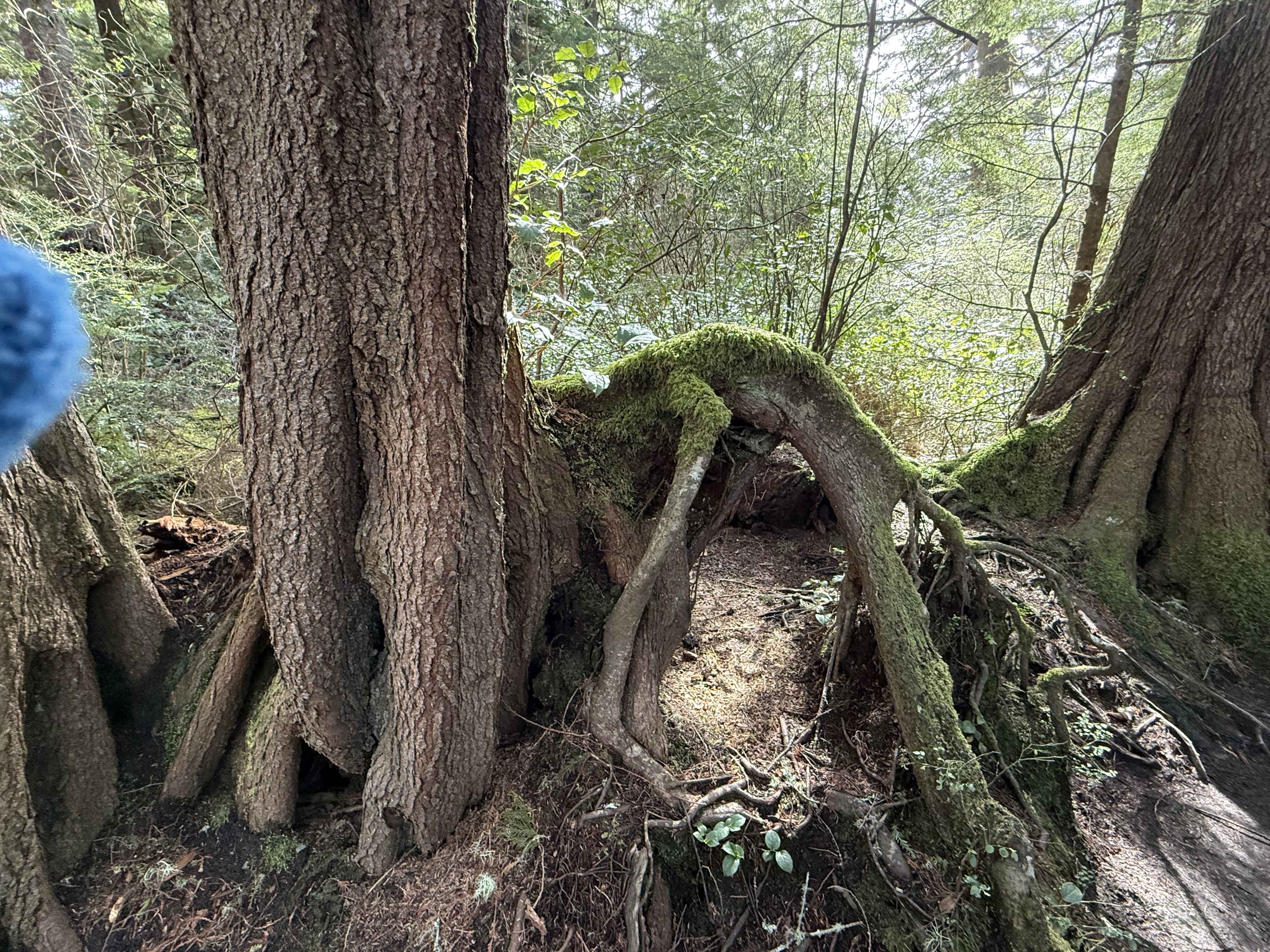
Plate 12. I had to throw this photo in because the root growing out of the tree(s) on the left looks like a dog that got its head caught in a hole, and died there. Its limbs of limp. Overactive imagination, I know. Nevertheless, this is a bizarre image because the dog is lying on top of a mound of soil. I’d bet there was a stump there that has decayed because the trees visible in this image are both composed of multiple trunks. A large tree died here (like the dog) and these are its adopted offspring. I would add that Cape Flatters, which is part of the Makah Reservation, has never been commercially logged. This is old-growth forest and this is a naturally occurring phenomenon.
Summary
Moisture drives everything on the Olympic Peninsula, soaking old volcanic and sedimentary foundations until the forest grows straight out of its own decay. Fallen logs become elevated nurseries, their wood breaking down under fungi and mosses until they’re more sponge than tree. Hemlock, cedar, and huckleberry take root on these platforms, sending roots around stumps and into the thin soils draped over ancient bedrock. Even the beaches tell the same story: waves sorting bones, shells, and driftwood carved from headlands shaped by tectonics and storms. It’s an ecosystem built on slow collapse and constant renewal.
Acknowledgment
I am experimenting with using CoPilot (aka ChatGPT) to help as I pursue my growing interest in ecosystems. I have been up front about where it contributed. It has been a great help, as well as an inspiration; if not for CoPilot, I wouldn’t have had the time of inclination to add these ecosystem NOTES to Rocks and (no) Roads. In fact, I’m tired of this entire series of posts, for which I get no compensation other than sharing my observations of the world. As a final note, CoPilot wrote the Summary and I stand by it.
Now I have to think about more than just rocks…
Cape Flattery: Conglomerates at the End of the World
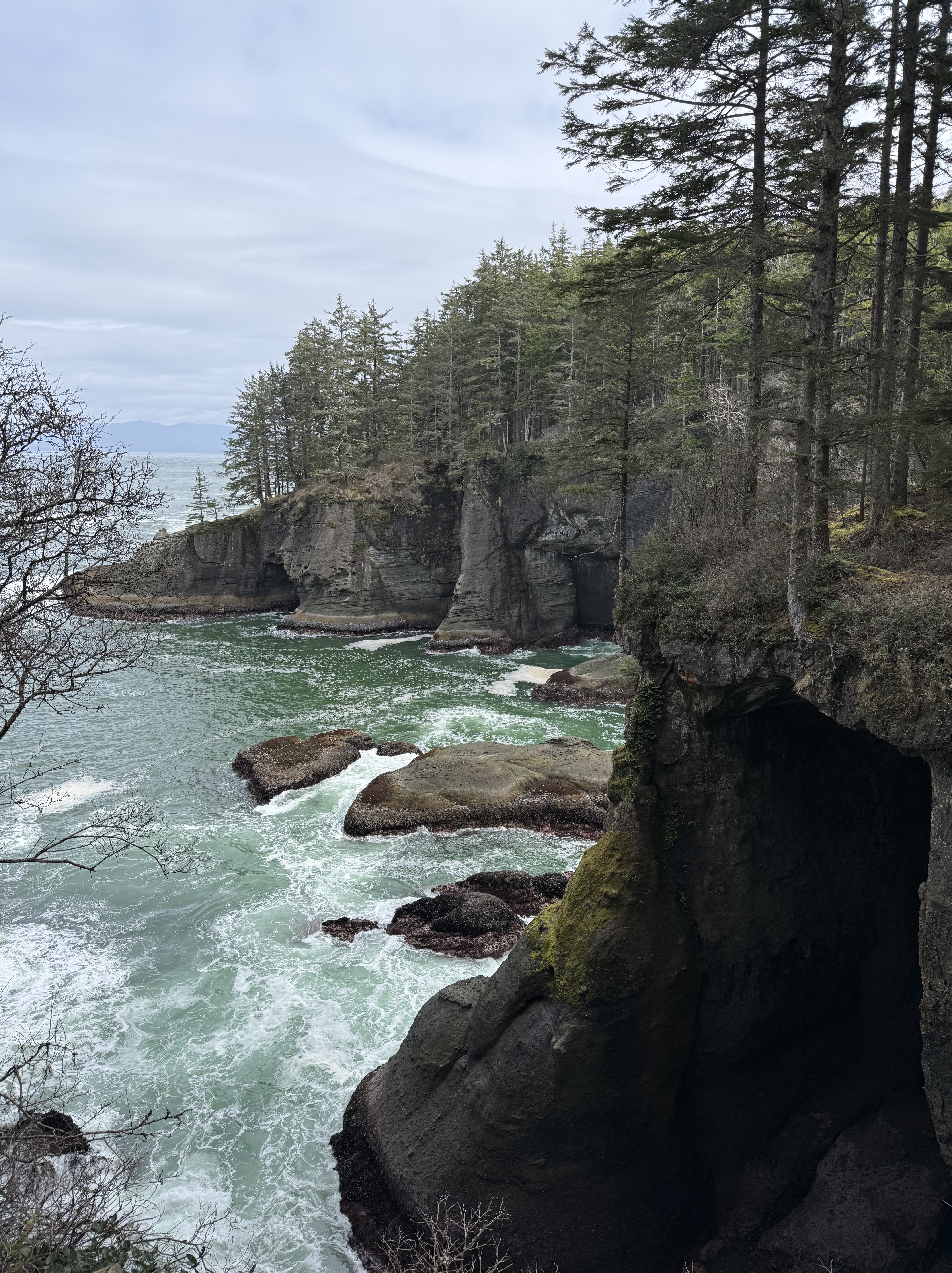
Figure 1. I ran out of road and land, ending up at Cape Flattery on the Makah Reservation. This is Location D in Fig. 2. A half-mile hike down a boardwalk took me to the end of the world, where the cliffs are about 80 feet above sea level. This photo is looking northward towards Vancouver Island, Canada, in the distance. Wave action has cut a wave terrace, a seen in the center of the image, and a series of sea caves.
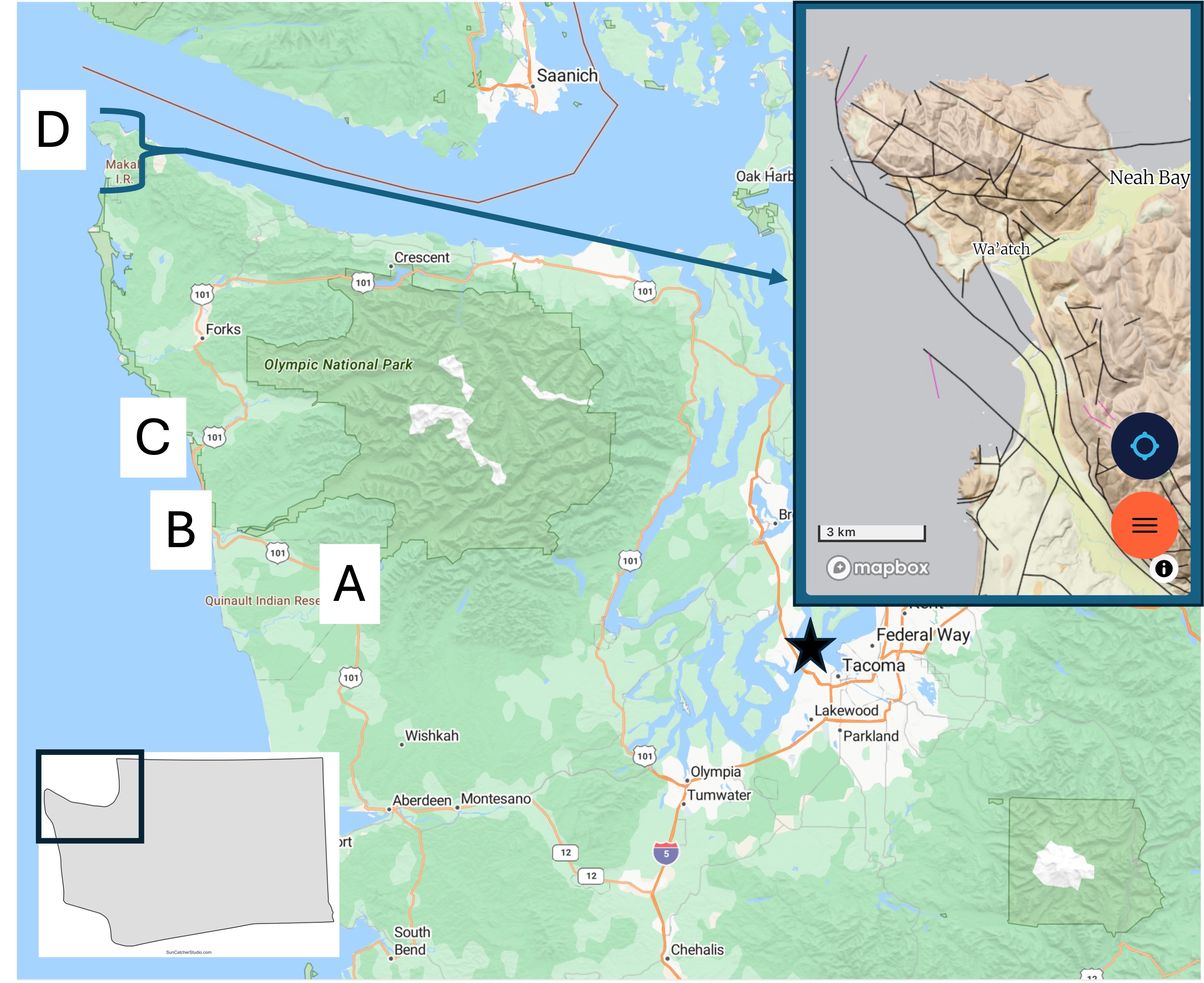
Figure 2. Today’s post takes us to Site D, which is shown in a geologic map from Rock D in the inset map. The rocks are a mixture of sandstone and conglomerate of Eocene age (56-34 Ma). This is the same time that the lower Cascades were being created east of Puget Sound. Note the large number of faults (thin lines) shown in the inset map. Many of these are strike-slip faults with motion of the opposing crustal block to the left, which would explain why the sedimentary layers in seen in Fig. 1 are almost horizontal, dipping slightly towards the sea.
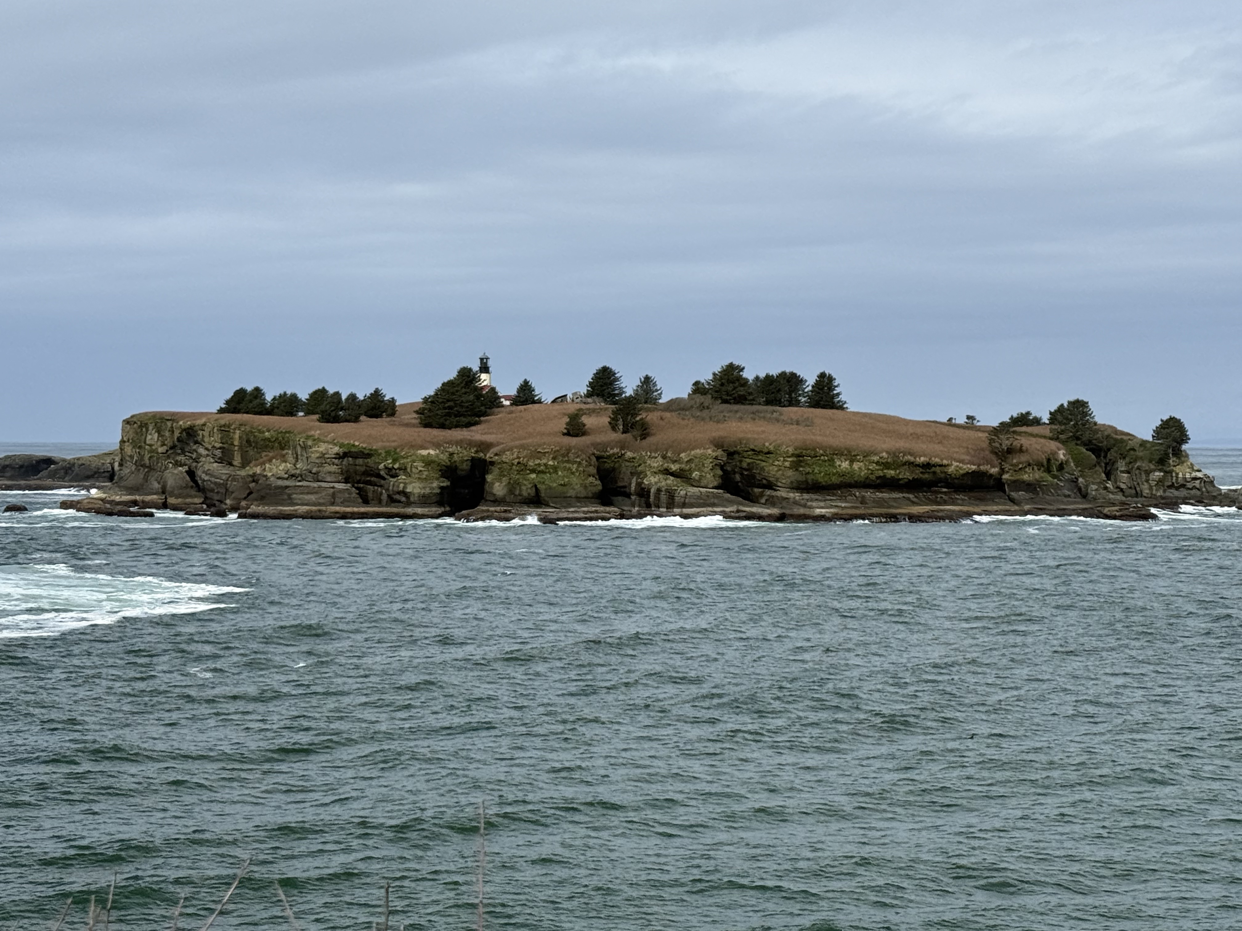
Figure 3. The sea stacks seen further south have been replaced with rocky islands like Tatoosh Island, which has a light house. Pacific Ocean seafloor (Juan de Fuca tectonic plate) is being actively subducted along the Washington-Oregon coast at about 2 inches/year, but the plate tectonic geometry is complex in this area. This could partly explain the large number of faults seen in Fig. 2 as well as the high elevation of bedrock. Maybe.
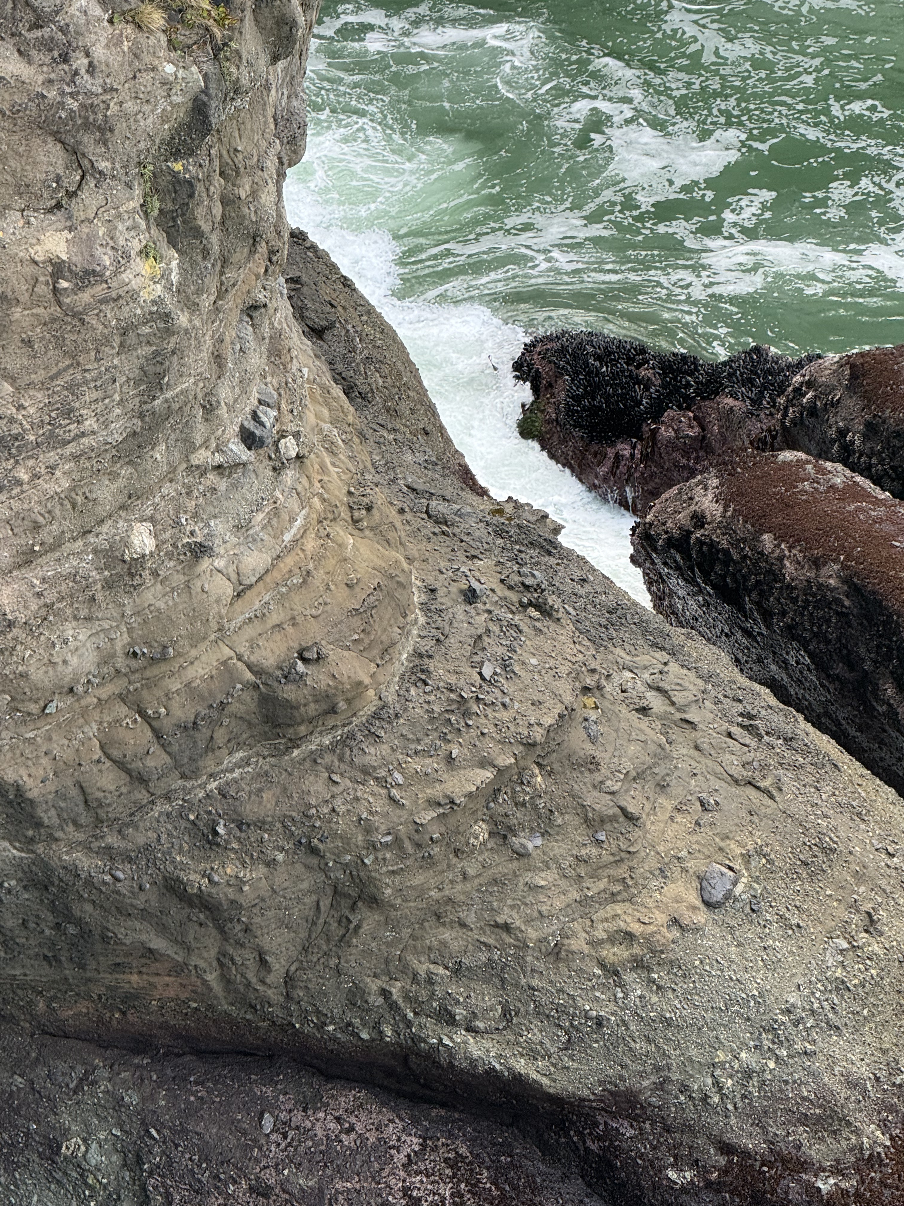
Figure 4. This photo was taken looking down towards the wave-terrace on the south side of the lookout point. For scale, the largest boulders are a couple of feet long, based on exposures at the surface of the trail. This is a textbook tectonic breccia. However, note that most of the rock fragments are rounded, so they have been transported some distance before reaching their final resting place. Some of the layers are relatively uniform with a few large boulders whereas others resemble the cobblestones we saw at Ruby Beach. Each bed might represent a single depositional event (like a landslide) or accumulation over years. These are marine rocks, deposited on a submarine fan, probably as turbidity flows. The process that created them is occurring now a few miles offshore, where the rocky outcrops we saw are eroding and supplying large and small fragments to a steep continental shelf.
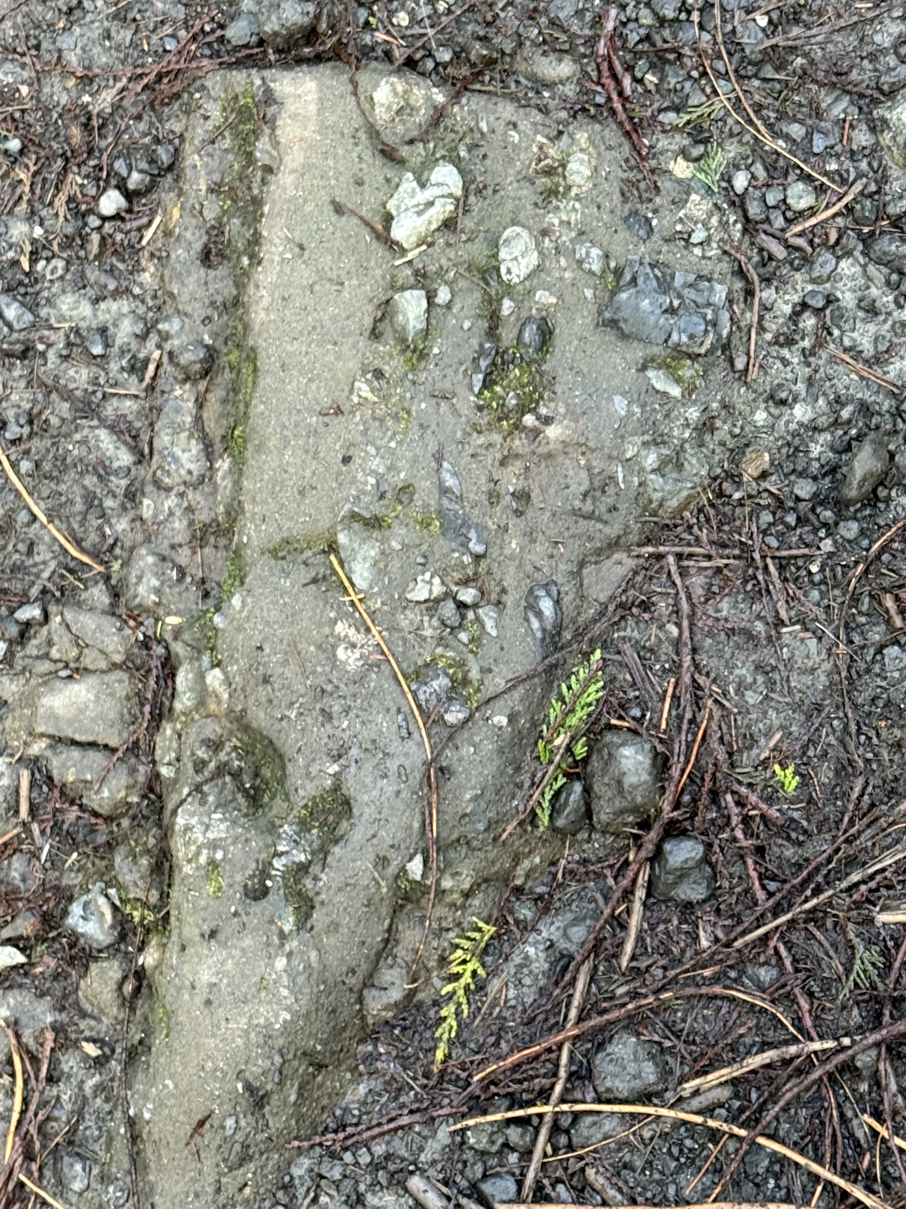
Figure 5. This image looks like run-of-the-mill gravel like you see on pathways and drives, but it is Eocene rock, and I mean solid rock (Note the large, gray piece protruding from the cliff in Fig. 4). This angular slab is about a foot in length. There is no Pleistocene glacial till in this area, even if the ground looks the same. This is a picture frozen in time, where an angular piece of what looks like sandstone, but could be andesite, slid downslope along with smaller fragments.
Summary.
This is the last of my geology posts from a weekend excursion along a hundred-mile stretch of the Washington coast. This is a high wave-energy coast with a tidal range of about 10 feet, the beaches covered with sand and cobbles. Sea stacks protrude from the beach, culminating in cliffs made of 50 Ma conglomerates. Beneath our feet, ocean crust was being subducted at several inches per year, feeding a system of magma chambers that are actively venting through volcanoes like Mt. Saint Helens, Rainier, and Mt. Baker. Rainfall drops along this coast at up to 12 feet per year, feeding streams that carry immense quantities of sediment into the trench created by the subducting ocean crust.
Geology doesn’t get any realer than this…
Tectonic Breccia at Ruby Beach
Figure 1. Ruby Beach is located about 10 miles north of Kalaloch Beach (Point C in Fig. 2), but the coastal morphology has changed substantially. This photo was taken at sunrise during low tide, exposing many outcrops of basement rock, which is the same unnamed sandy rock formation we saw before, but its composition has changed.
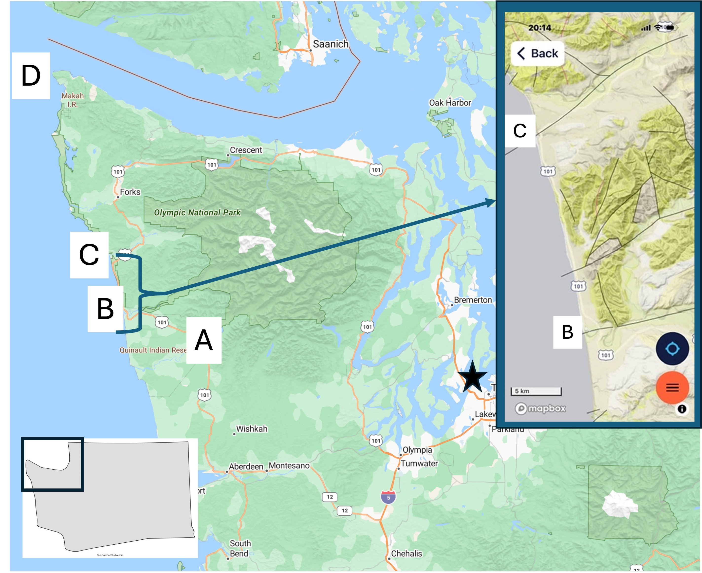
Figure 2. Today’s post describes the coastal geology at Site C. I’ve already discussed the Quinault Rainforest and Kalaloch Beach. I will focus on what is different from the previous post. The inset geologic map from Rock D will be referred to below.
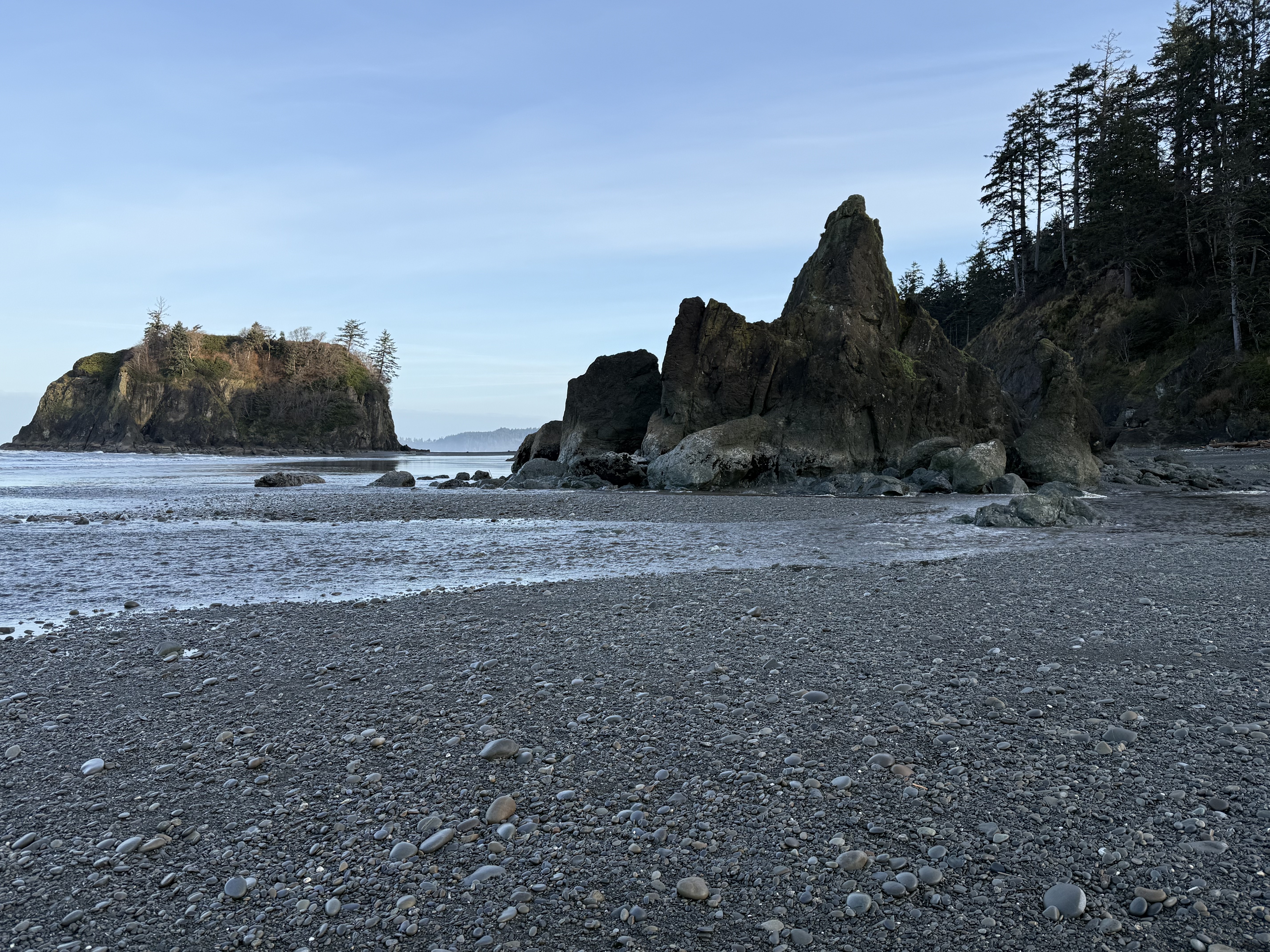
Figure 3. Basement rock of general Tertiary age (66.5-2.4 Ma) is more exposed here although it is overlain by Pleistocene glacial sediments. This photo shows a rocky island that can be reached at low tide, and a promontory. The beach is composed of rounded cobbles in a matrix of sand, silt, and some clay. The finer sediments are restricted to the lower swash zone (Fig. 1).
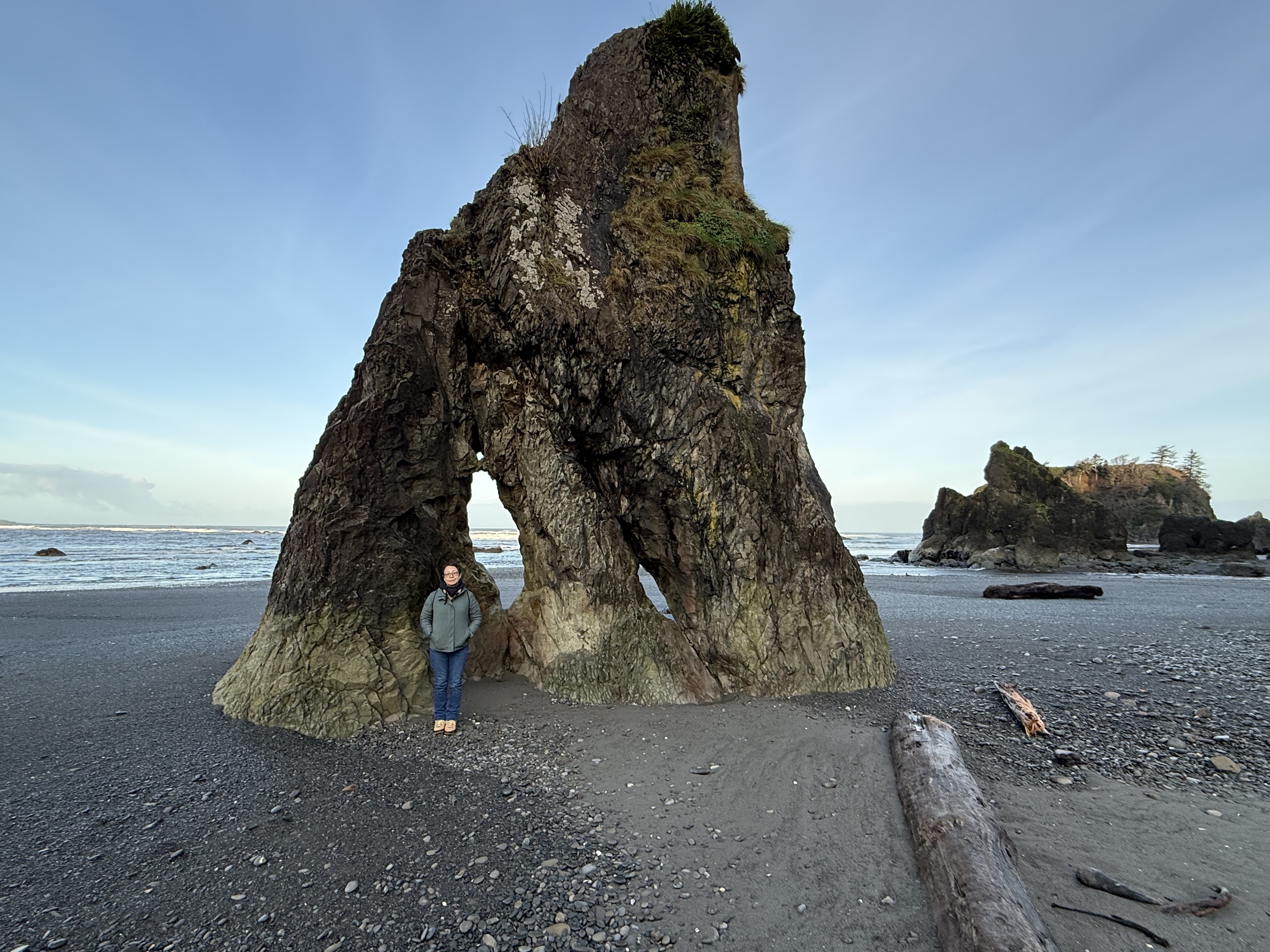
Figure 4. This is a sea stack, a standalone rock pillar. The beach is a thin veneer spread across a rocky basement that is more irregular than we saw at Kalaloch Beach, where the outcrops resembled a wave-cut platform more than we see here. The first thing that occurs to me is that this area hasn’t been exposed to the erosive power of waves for as long an interval. Maybe. Let’s take a look at the inset map of Fig. 2. The black lines represent geologic faults, where rocks have been displaced by tectonic activity. Note that the stretch of coast we’re concerned with is bounded by faults perpendicular to the coast. Furthermore, there is another fault separating Sites B and C. I should take a moment to point out the relationship between faults and river valleys: faults create weak zones within the crust, which are exploited by erosional forces like water and glaciers. Thus we see valleys at both B and C; however, the intervening fault is part of a complex fault system that appears to have led to less surface erosion. Faults cannot be directly dated, only indirectly by the age of the rocks they displace, and in this case those rocks are themselves difficult to date. Thus, it is possible that vertical movement, even a few hundred yards, could have made this beach more irregular than Kalaloch Beach only a few miles to the south–on the other side of a fault. Plausible, but don’t bet your retirement on my hypothesis.
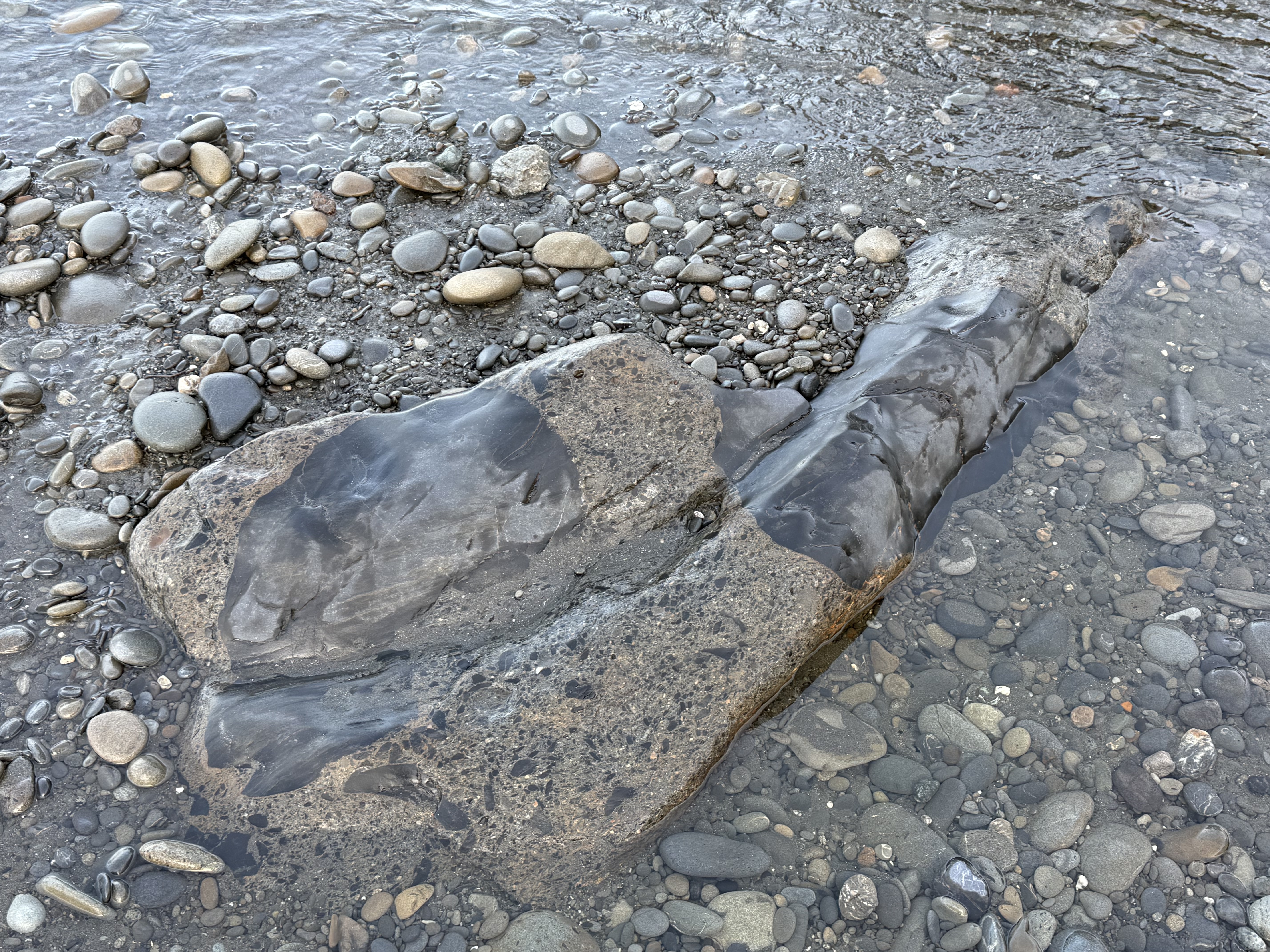
Figure 5. Back to the rocks. This photo puzzled me because I’m not an experienced field geologist, despite my regular posts; however, CoPilot came to the only plausible conclusion: the primary material here is a breccia/graywacke; the smoother material is calcite filling fractures that occurred during faulting (see Fig. 2 inset). We must ALWAYS remember that a sedimentary rock’s history isn’t confined to deposition; a lot happens during burial to many miles and subsequent exhumation and deformation.
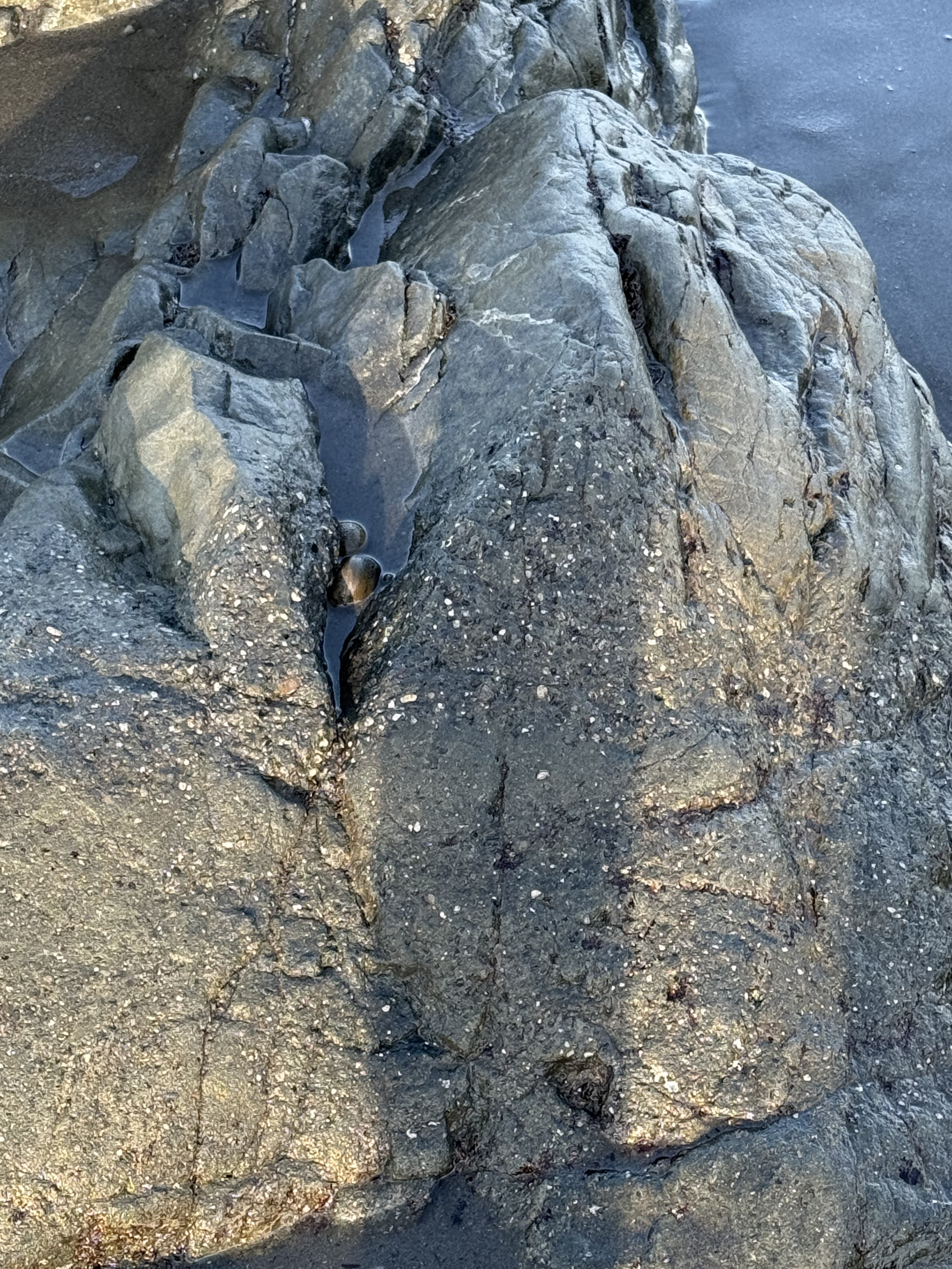
Figure 6. This photo shows a typical graywacke texture with layering, as you might expect with episodic deposition of event beds (e.g. turbidites on a submarine fan); but the upper part of the image is similar to Fig. 6. I asked CoPilot about the source of so much Calcium and I agree with its answer: Some of the Calcium came from marine invertebrates living in the area, but the bulk arrived later, when the sediments were buried deep (several miles) within the accretionary wedge where Calcium is released from minerals like feldspar. It’s really hot down there and the pressure is INTENSE.
Summary.
Not only was Ruby Beach a beautiful area on a cool winter/spring morning, it gave us more insight into the complex life of the earth’s crust. These rocks were probably deposited as poorly sorted graywacke on a steep continental margin overwhelmed by sediment eroded from the rising Cascades (more than likely the Eocene, 56-34 Ma). They were buried for a few million years, before being scraped off the subducting oceanic crust and filled with hot fluids that originated from deeper within the accretionary prism. They were never so humiliated that they became melanges but it was a pretty rough ride, even for a rock.
To put this all in perspective, dinosaurs had just gone extinct (~65 Ma) when all hell broke loose and the Cascades Subduction Zone became very active about ten-million years later; the earth became hot as hell, mammals and birds were beginning to get their legs and wings. While the ecosystem changed dramatically, these rocks were being ground up and spit out by the earth because they were stuck on the end of its tongue. We hominids didn’t come along until these rocks were exposed to the vagaries of the weather and had eroded for a VERY long time.
Try not to laugh at the punch line: Our entire history is contained in the Pleistocene glacial sediments overlying these fairly young sediments.
It boggles the mind…
Coastal Geology of Kalaloch Beach
This report is the geology supplement to my general post about the Olympic Peninsula. It focuses on the geology of the beaches because, to be honest, Quinault Rainforest was impenetrable, physically and geologically, without massive logistical planning and support. What I found was more than I expected.
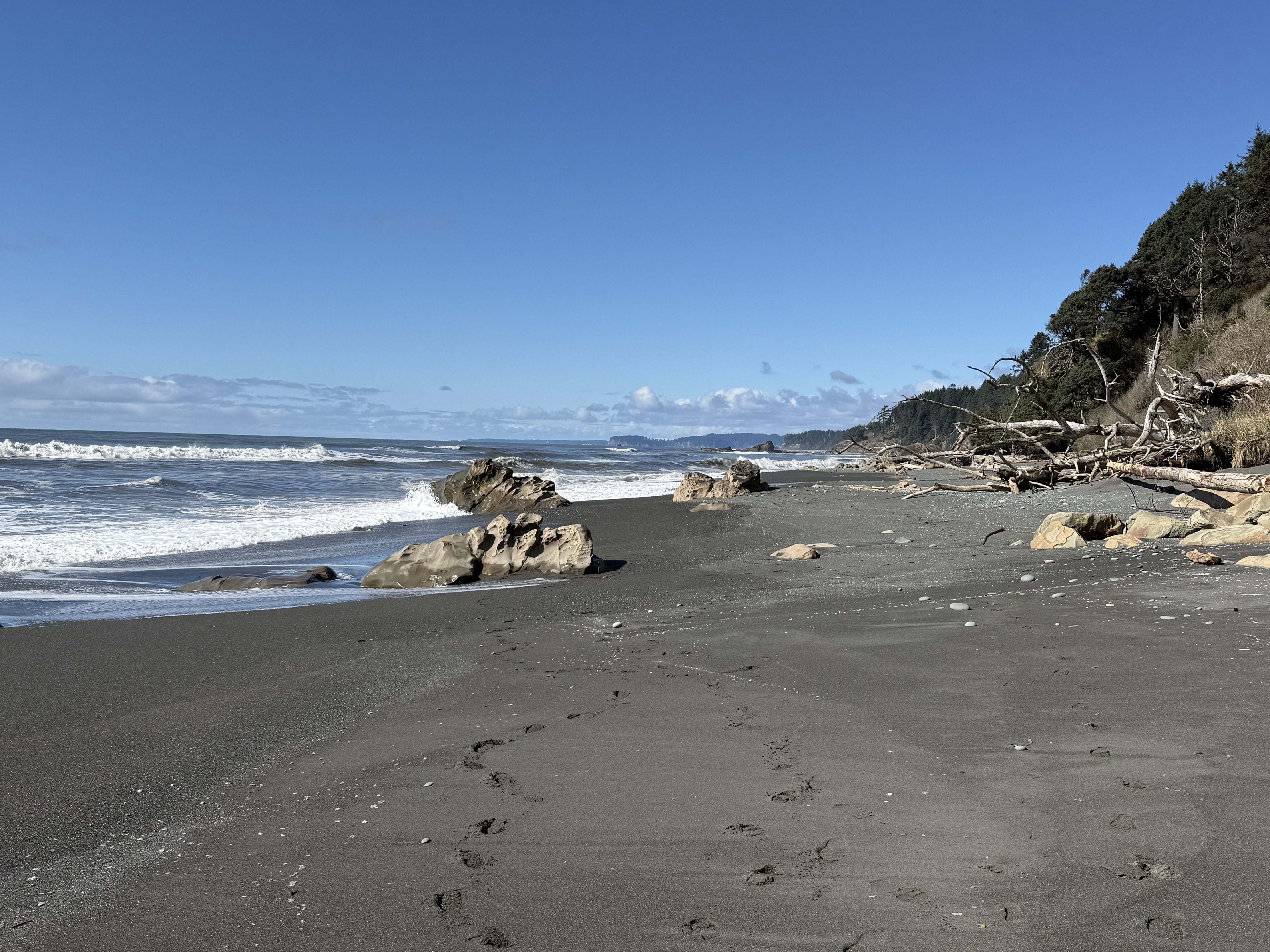
Figure 1. Photo looking north along Beach 4 at Site B in Fig. 2. The tidal range is about 10 feet here and the primary sediment consists of sand with a substantial mud component. The rocks seen in this image are bedrock that protrudes above the veneer of beach sediment. The cliffs to the right comprise glacial till that is less than 2.4 my old (Ma hereafter) deposited by glaciers during the Quaternary geological period. This photo was taken near low tide. The dark color of the beach surface is caused by the relatively large clay component (i.e. mud).
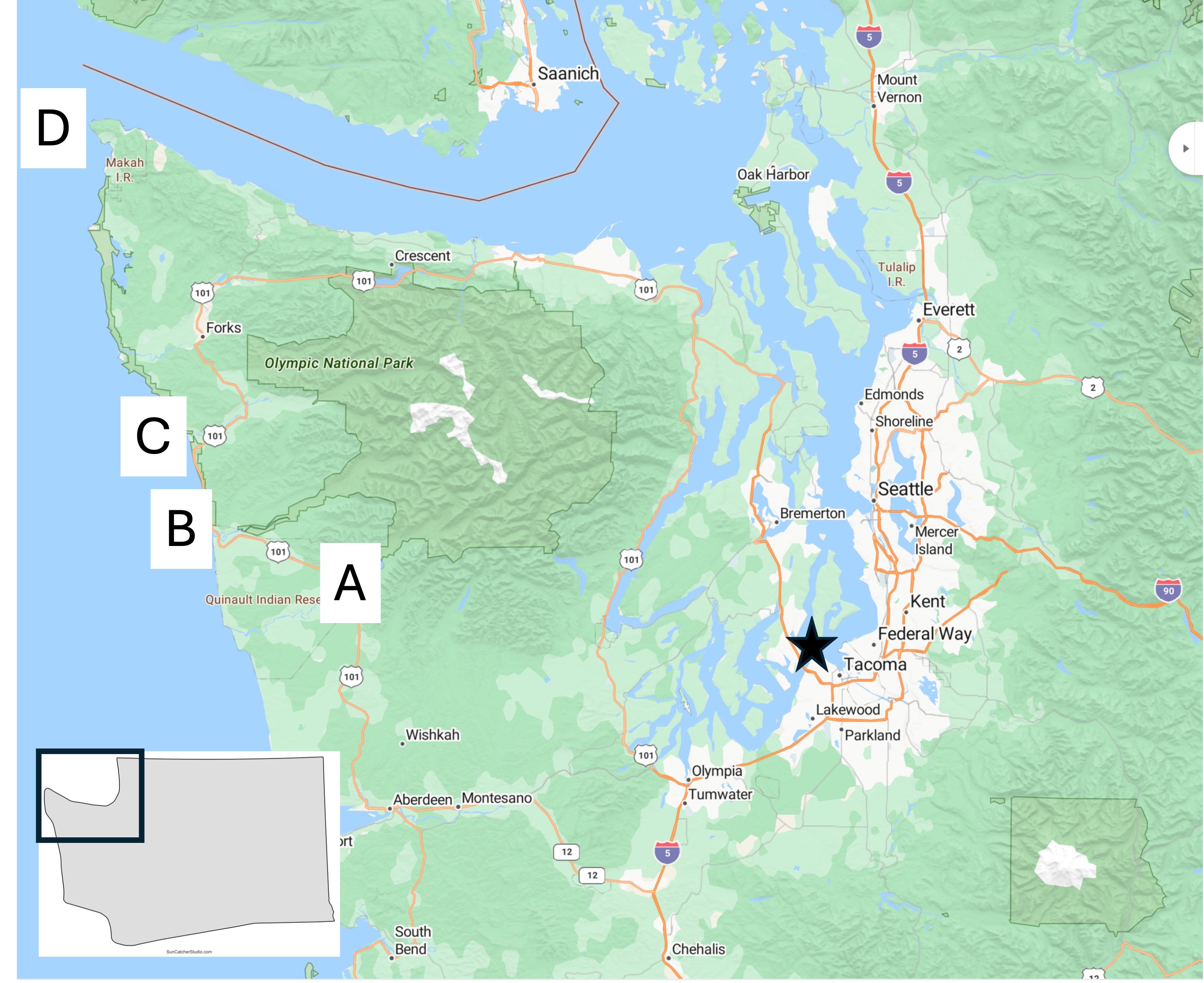
Figure 2. Location map of today’s field area, which will focus on Site B.
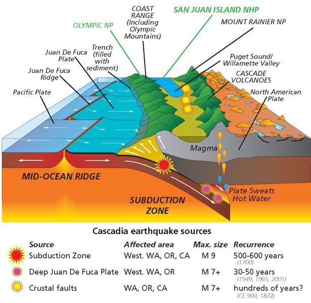
Figure 3. Schematic of the Cascadia Subduction Zone as it appears today. The Coast Range, which includes the Olympic Mountains, consists of sediments and volcanics that have been scraped off the subducting ocean crust. The white arrows at the front of the image don’t reflect the actual geometry of these sedimentary rocks. We’ll get to that in a minute. Today’s post will focus on these sediments and discuss their original depositional environment during the Tertiary period (~65.5-2.4 Ma), as well as evidence for structural deformation.
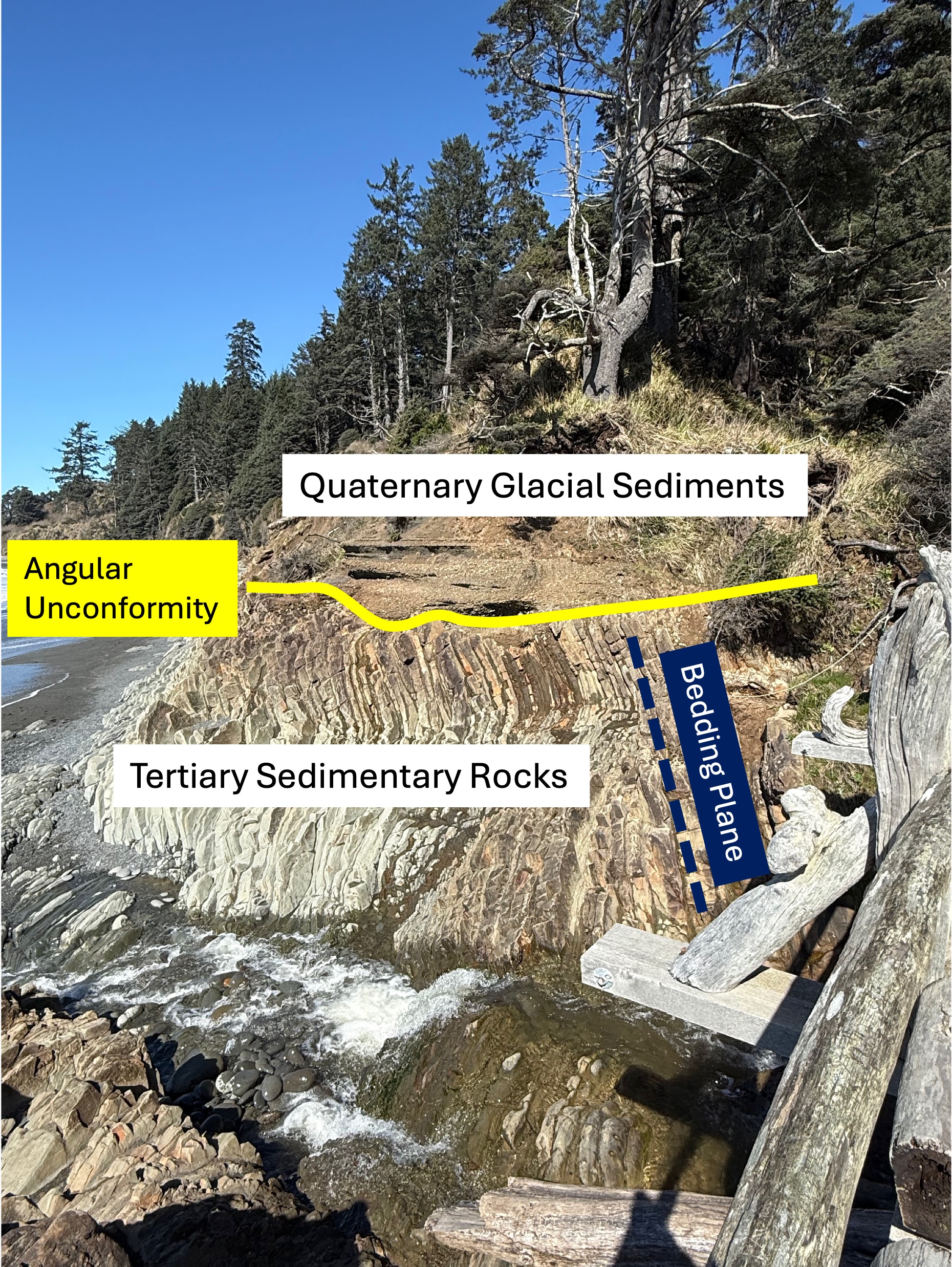
Figure 4. This photo has been marked-up to highlight what might not be obvious to a non-geologist. First, older sedimentary rocks have been tilted to a high angle (dark blue bedding plane line) by faulting, as suggested in Fig. 3, and exposed to erosion at the surface. This erosional surface is shown by the yellow line. These Tertiary sediments were buried several miles beneath the ocean surface where the grains were cemented by heat and pressure. We don’t know exactly when this occurred or how long this process took, but they were later overlain by younger glacial sediments during the Pleistocene epoch (2.4 Ma to present). The age of sedimentary rocks can’t be pinned down unless they contain material datable by radiometric methods or, more qualitatively, by the fossils they contain. Sandy sediments don’t contain fossils very often and I didn’t find any radiometric ages in either Rock D or the USGS geologic map, so I guess the Tertiary date is the best we can do for now.
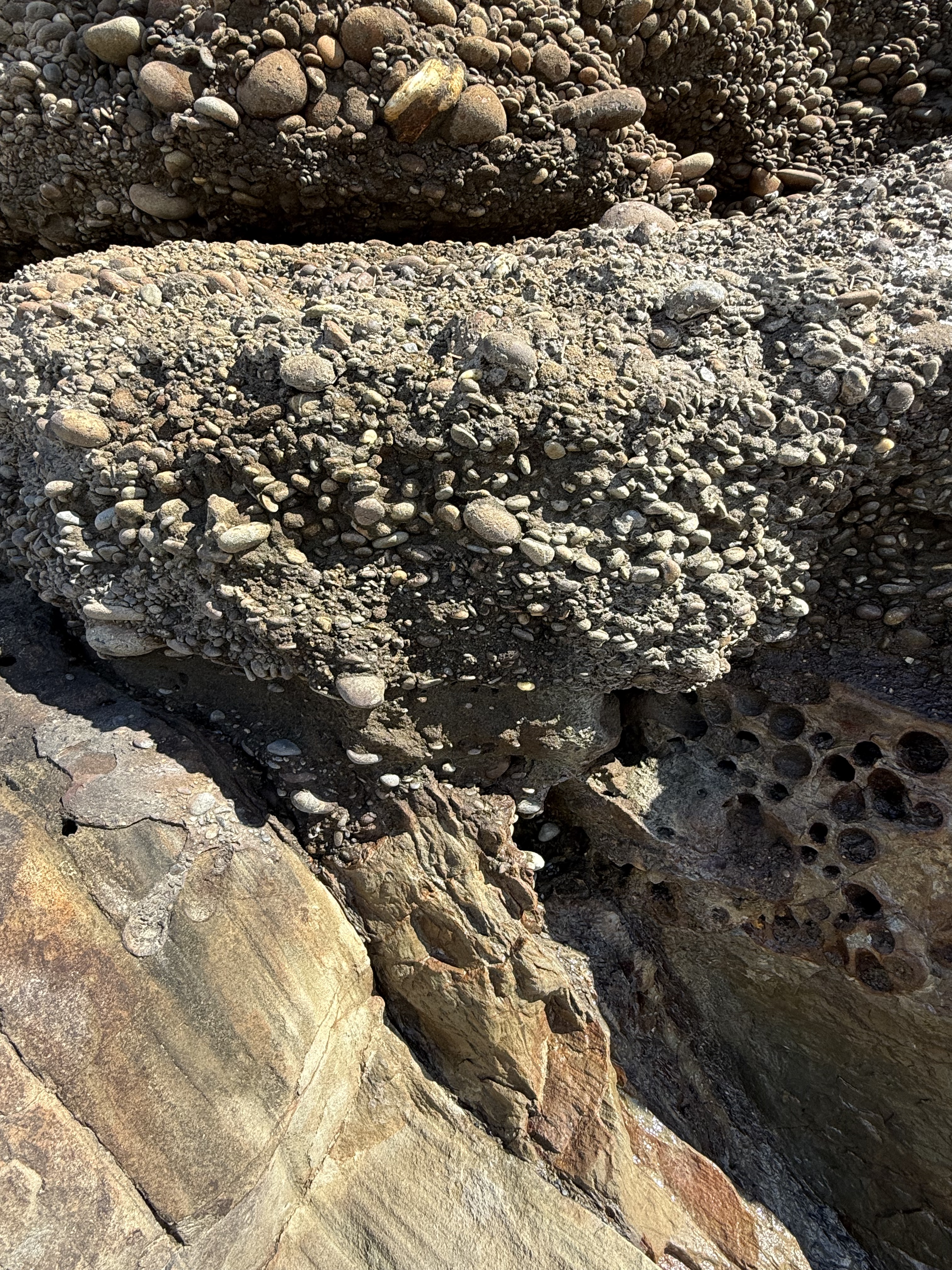
Figure 5. Close-up photo of the contact between the Tertiary rocks and the glacial till. Note that the cobbles aren’t falling out of the fine matrix sand and clay; this is because these young (>2.4 Ma) conglomerates have been partially cemented and, in fact, they were stuck to the older rocks below. This photo tells us a lot: 1) the older rocks were tilted at depth (maybe a mile or more) and then pushed upward as suggested in Fig. 3 until they were exposed to the atmosphere; 2) in a very short time they were covered by cobbles (~2 inches or less) that had already been rounded in a river, which takes several miles of transport; 3) the type of sediment varied rapidly, from coarse sand to cobbles, probably within decades if not years, due in part to periodic changes in surface drainage (e.g. the advance and retreat of glaciers); 4) this is a good example of the principle of Uniformitarianism–the present is the key to the past: we see similar processes occurring today along the many streams and rivers draining the Olympic Mountains. But what about those pesky Tertiary sandstones?
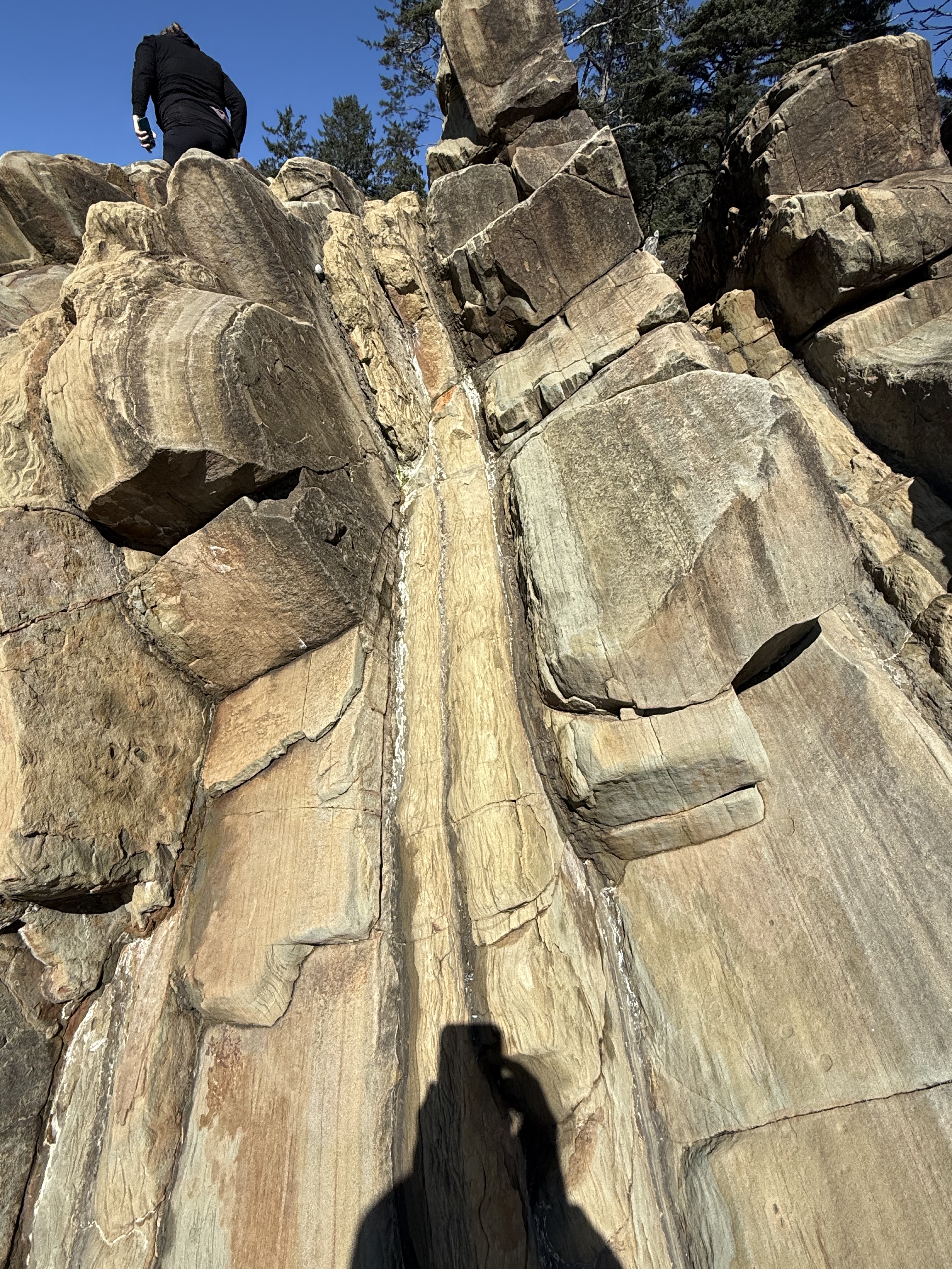
Figure 6. This photo of the Tertiary sedimentary rocks reveals packets of thin-bedded fine sandstone with intercalated dark layers of (presumably) mud. I didn’t see any cross-bedding, which would indicate deposition in a river or nearshore dominated by waves or currents. What is obvious that this ancient (~50-2 Ma) shoreline was receiving sediment from a distant source, probably the volcanic highlands of the modern Cascades (see Fig. 3). Let’s take a closer look at one of those wavy layers.
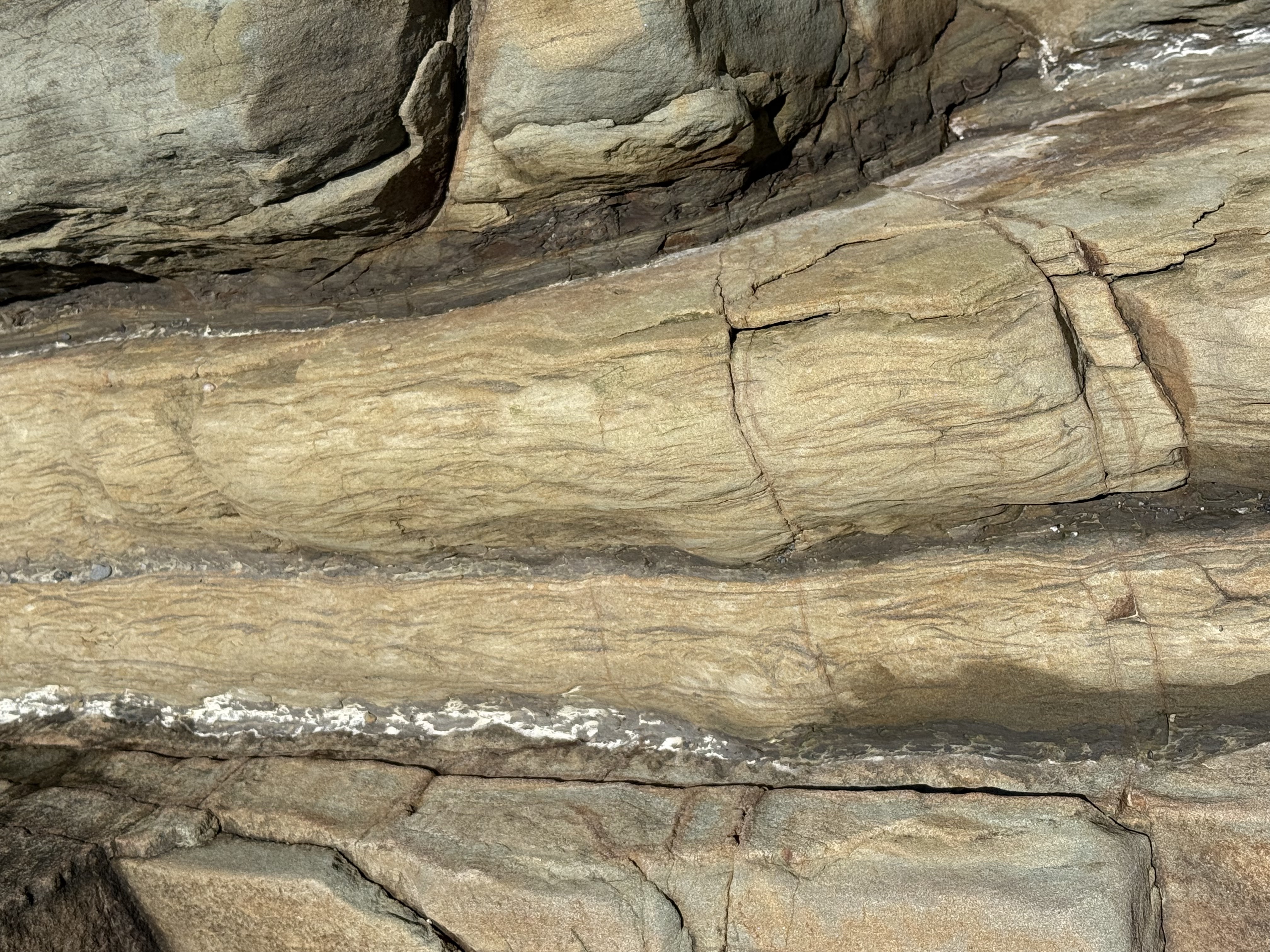
Figure 7. Close-up image of a thin layer (about 3 inches), showing what is called Flasier bedding. This is found in modern environments where high-energy (e.g. waves and tides) periods are interrupted by quiet times during which fine sediment can be deposited between ripples. It is indicative of a shallow marine environment.
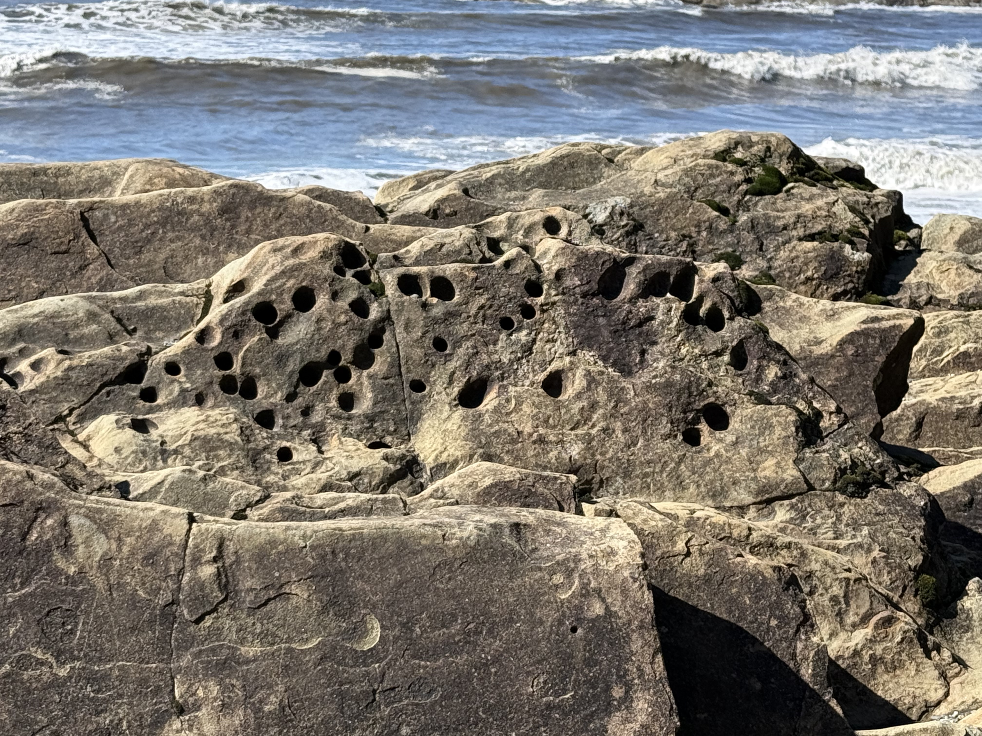
Figure 8. These holes were evident throughout the exposure. They are problematic and probably originated in several ways; however, one plausible explanation is that soft-bodied animals like worms burrowed in the sediments and their burrows filled with sediment with a different composition (e.g. fecal pellets). These channels then preferentially eroded when subjected to the harsh nearshore environment in which they are found. The presence of such holes at the unconformity (see Fig. 5) proves that they predate deposition of the overlying glacial till. Unfortunately, such trace fossils don’t tell us anything about geologic age, only that this seashore was teeming with life.
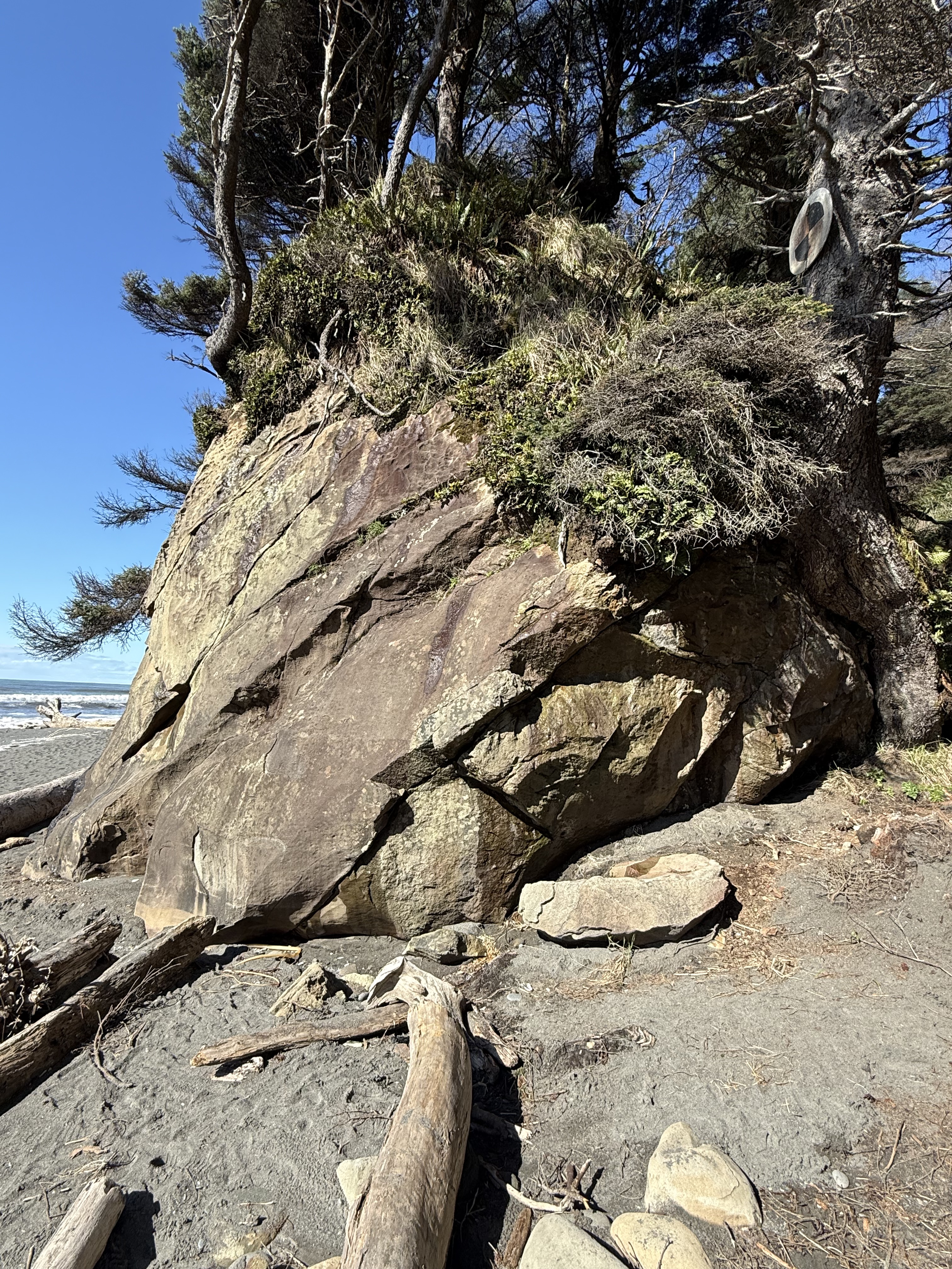
Figure 9. I stopped at another accessible beach a couple of miles south, but still indicated as Site B in Fig. 2, where the rocks were sandstone but with very little clay. The beds seen in this photo were thick (1-3 feet). They were not deposited in a high-energy, environment like those we saw before; they were probably deposited on the shoreface below fair-weather wave base–possibly part of a nearshore bar or barrier island. After deposition and burial, they were tilted less steeply than those seen further north (Fig. 6). The unconformity is seen in the upper part of this image, but it doesn’t seem to have as many rounded cobbles as before (Fig. 5). I have no way of knowing the relative age of these two exposures; this Tertiary rock unit is approximately 3000 feet thick and represents millions of years. All we can say for certain is that this shoreline wasn’t that different from what we observe today. Uniformitarianism in action.
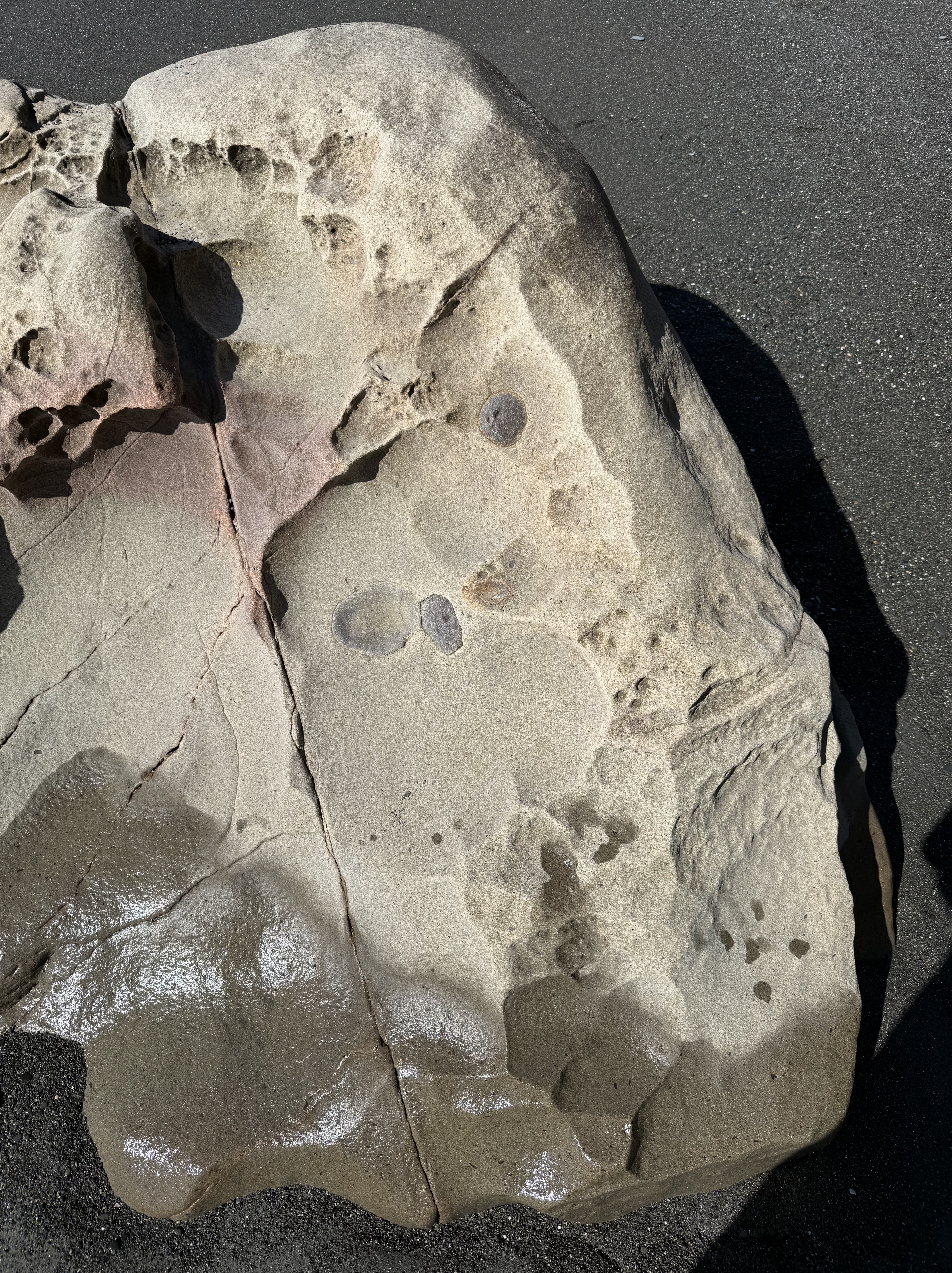
Figure 10. This exposed outcrop within the tidal zone reveals what are probably concretions of iron oxides, formed during early diagenesis. They superficially resemble fossils, but that is not the case. As the sediment was squeezed during burial, incompatible elements like iron formed irregular blobs in an otherwise uniform quartz sand matrix.
Summary
This coastline was part of the Cascadia subduction zone during most of the Tertiary period. Sediment, including a lot of sand, was eroded from rocks being uplifted further inland where volcanism was active, especially during the Eocene (55-35 Ma). Beaches like those we see toady were common, as well as the various depositional environments found along the Olympic peninsula, including fluvial and submarine fans, beaches, and cliffs. But no glacial sediment.
These sediments were buried as more material was removed from the rising orogenic belt, which included granitic rocks with lots of quartz. Eventually they were caught by the complex trench uplift (see Fig. 3) and scraped onto the edge of N. America. This involved faulting primarily, suggesting this was a fairly shallow process (folds occur at depth where rocks are ductile). The tilted rocks were eroded for millions of years; then, about 2.4 Ma glaciers (nothing to do with subduction) covered the region and deposited all kind of sediment: rivers, lakes, undifferentiated till, moraines, etc.
Just as the East Coast of America has been a passive margin for more than 200 my, the West Coast has been a convergent margin. Instead of being steadily worn away by wind and water, these rocks are rising out of the sea at about 2 inches per year. And what a ride it is…

Recent Comments