
Lonestar Jamboree 2015: Prologue
The next series of posts discuss the geologic time travel across the Mississippi Embayment into Texas. My destination is Barnwell Mtn Recreational Area, which is run by the state, unlike Hawk Pride, a private park. Before I can get to Texas, however, I must cross the down-warped Cenozoic (<65 mya) rocks of the MS embayment. I am going to try and take pictures of the contacts seen in the below image as I drive up, because I have installed the WordPress Ap on my phone (good luck with that!). Thus, I won't say much here…

These rocks are time-synchronous with the rocks I briefly described as I drove to Hawk Pride last month, but they are different because the sediments that formed them were further from a source of erosion (i.e. Ancestral Southern Appalachian Mountains). This trip, as I drive northwest, the rocks get progressively older because of the down-warping beneath the MS river (note that erosion removed any rocks that were exposed to the wind and rain…etc).
This photo shows the geologic map of NE TX, with the park indicated by a black circle. The oldest rocks I will encounter are Eocene Claiborne Group sedimentary rocks, which were deposited in an environment just like the mouth of the MS River today!

The dominant rock type in the park (Gilmer, TX, Ushur County) is a sandstone, but anyone who has been wheeling there will tell you about the sticky! mud. The name of the primary stratigraphic unit (aka formation) is the Queen City Sandstone (a group comprises several formations), but I bet there is some mud in there if the sediments were deposited in a delta front environment!
This topographic map, with the very rough outline of the park, shows the topographic relief to be about 200 feet, but the park encompasses the entire mountain. I hope to see if I can identify changes in the sedimentary facies within this small area.

Looking forward to a great time-travel trip…see you then!
Mardi Krawl 2015: Epilogue
I want to add one last comment, which addresses my original objective in this wheeling/geology trip; why is Mountainside, which is a low-gradient road cut down the north side of Thompson Hollow, more difficult to traverse when it rains than Big Hill, which goes right up the mountain?
My limited field work suggests that the answer lies in the original distribution (horizontally as well as vertically) of clay sediments in the Mississippian. The transition from shallow ocean (i.e. fossil-rich thin beds of limestone and dark shales) to coastal sediments (i.e. the Hartselle Fm. red sandstones and shales with some limestone) during this period produced rapid changes horizontally in facies, which are environmentally dependent groups of sediments (later rocks). I think that coincidentally, there was a barrier island system on the south side of Thompson Draw with thinner layers of mud between thin sand layers. Thus, Big Hill and Mountainside must traverse more shale (now mud) than 1/2 mile to the south. When Mountainside was cut with a dozer, it produced a trail/road that has a greater extent of slippery mud when it rains. This same section (from ~500 -700 feet) on Big Hill is crossed in a series of swales and sandy ridges that are easier to traverse in sections.
There are slippery sections of John’s Way (the escape route out of Thompson Draw) but overall it is sandier.
Wheeling in the Mississippian
This post attempts to relate the previous comments to the four-wheeling experience in northern AL. First, I am going to show some photos of trucks meeting these rocks up close. This photo says a lot about HPORV park…my truck is parked on a flat, muddy, area with 3-6 foot ledges to the right side.
This was taken in the Hartselle Fm., which contains sandstones and shales (i.e. sand and mud). The shale was originally mud and when the shale, which is the rock that results from ~20 km depth of burial, is exposed to rain and weathering, the result is mud! This same spot is slimy when it rains (which it did the same night after this photo!). But it is not a mud hole because it is underlain by sandstone rock, which prevents deep erosion by truck tires.
I just had to show my trail companions’ response to this wheeling experience…they only get up when thrown to the floor during downhill stretches and when I set the parking break…LOL

This photo, taken the next day, shows how the trail changes after a heavy rain and the mud is liquefied by vehicles and hysteresis.
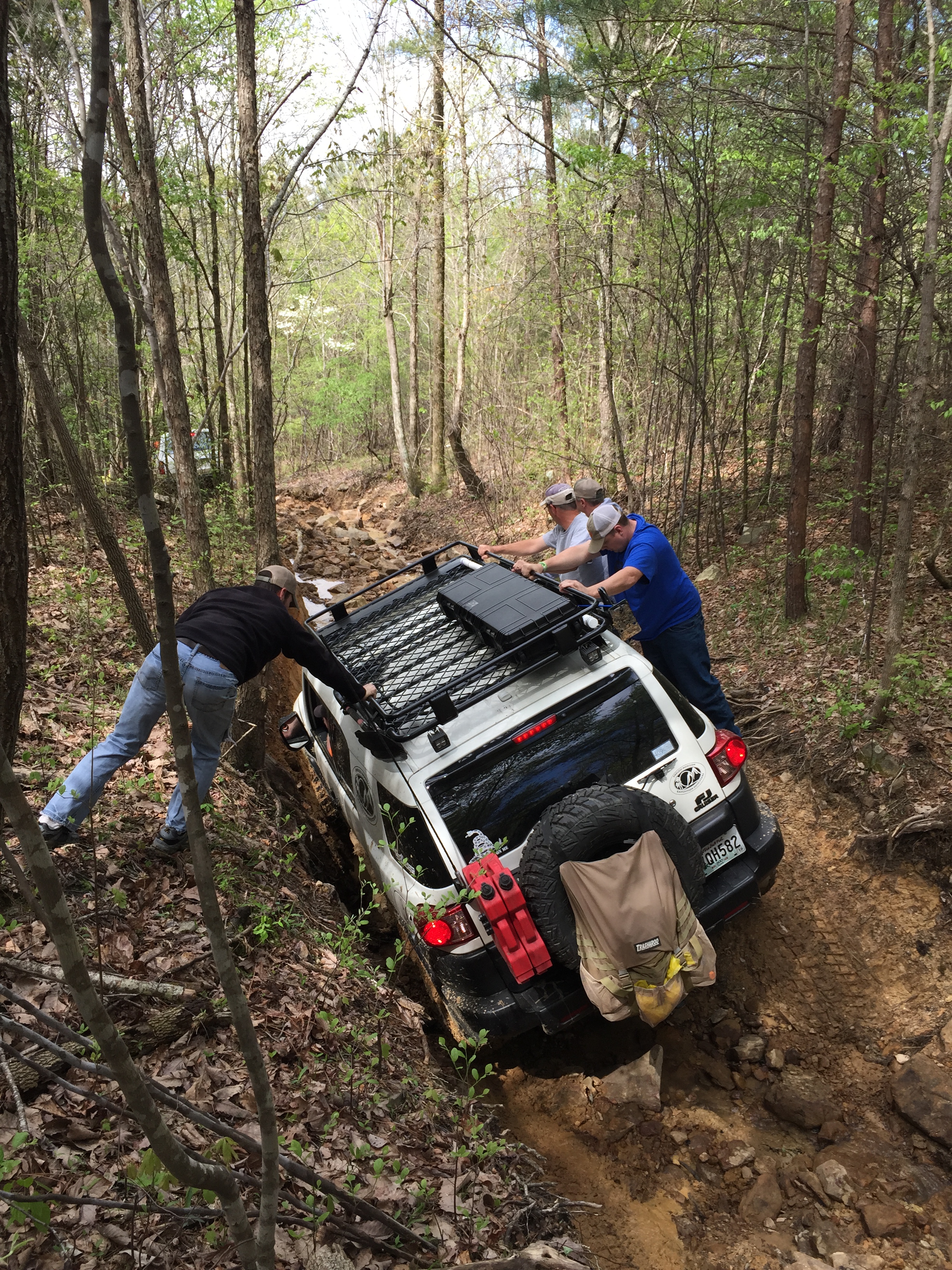
When the trail crosses a natural drainage (it rains in AL!), the crossing is very difficult, as demonstrated by our trail leader, who had to winch himself…the rest of us used tow straps or made it (50/50).
The geologic map uses the symbol Qal for the recent (~10000 years) sediment that accumulates at the of bottom hills like those surrounding Thompson’s Draw. Here is a photo of everyone breathing a sigh of relief near the lowest point of the park…the lowest point includes the “mud bog”, but it was just too hard to get there after the rain…LOL!
One of the results of weathering of a sandstone is the accumulation of blocks downhill. I showed some photos of these in a previous post. We took a trail on the north side of Big Hill that shows what this is like up close. This first photo shows the entrance to a natural gulley, which really works the suspension.

It took some human weight to keep this truck on track…
And then he had to drop over a ledge of Hartsell Fm. sandsone, which proved too high for his truck…
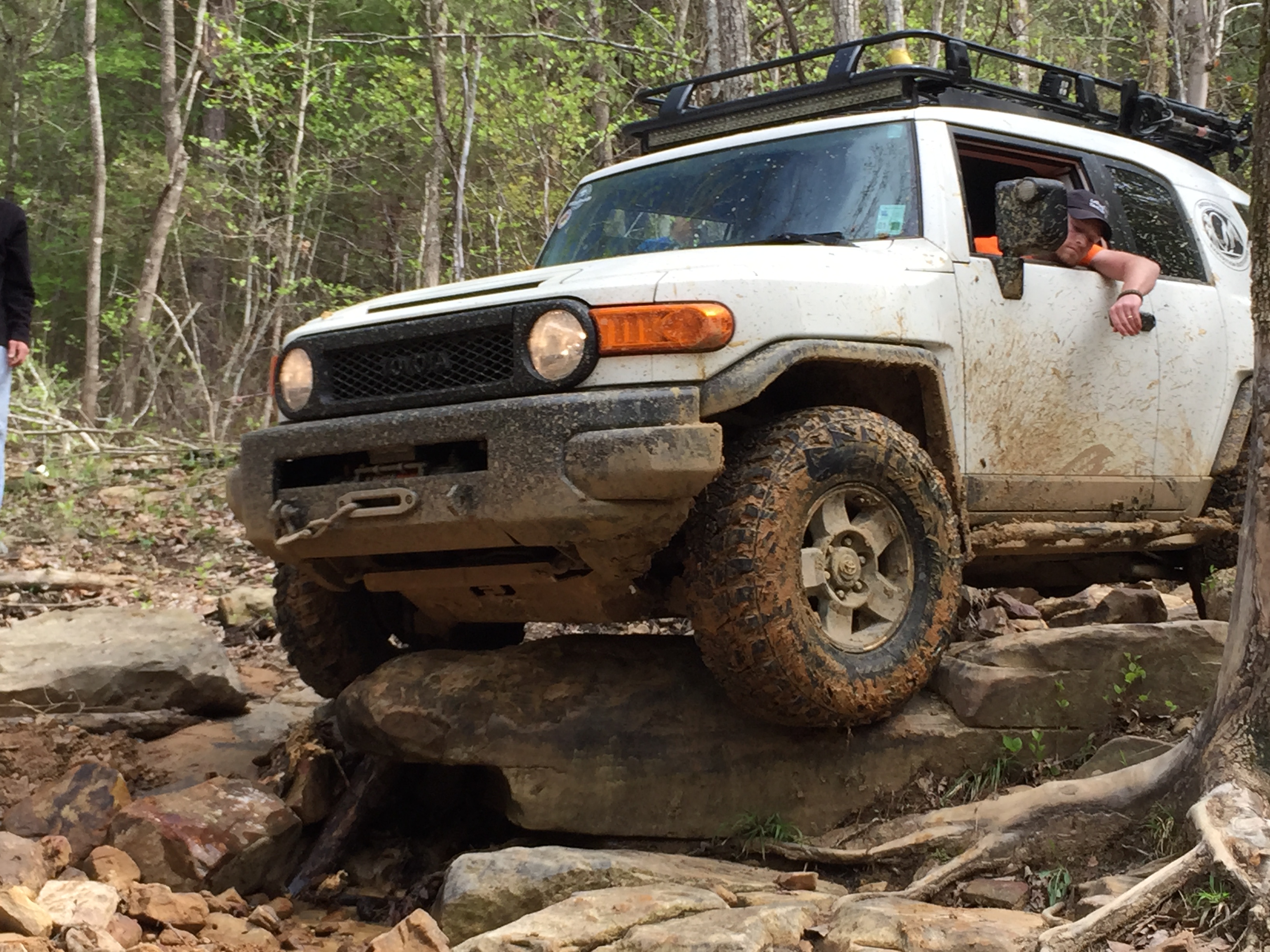
He got some winching from the trail leader and made it until an even bigger ledge appeared (sorry, no photos…I was helping…LOL). I made it down this ravine with no assistance partly because it is always easier to follow and see how the rocks fall (so to speak). My last photo is of the tranquil scene from the top of the Hartselle, where rain and snow haven’t produced the difficult landscape we traverse below.
My final comments relate to the similarity of the environment ~320 mya and those today, notwithstanding the elevation changes. These rock were all flat and all relief is due to erosion. This is very different from the situation 1000 miles to the north, where the slightly younger Pennsylvanian Pottsville Fm. represents the mountain building occurring there at this time (see my previous post). The northern ancestral Appalachian Mtns were close to the massive collision whereas the southern extent (i.e. AL) was a more peaceful environment, with barrier islands, bays, mud flats, and shallow seas. Even after ~300 million years we encounter this geologic memory of those environments, remembering that our ~400 feet drive up and down Big Hill traverses about 20 million years…LOL!
Changes in rocks, changes in wheeling: Pride Mtn. Formation
As noted in the previous post, the Pride Mtn formation was dark shales and sandstones at the type locality I visited. The previous post discussed the younger (on top…Upper Mississippian…~330 mya) Harstelle Formation. This post shows some photos of the Pride Mtn Formation. After meeting Big Hill from Mountainside, I stopped and collected a hand sample, which is limestone (HCl fizzes in contact), and took a photo of the exposure. Here is the exposure, after hundreds of drive-overs by four-wheelers. 
Even after so much punishment, this bivalve (unknown to me at this time) survived! 
After driving around a while, I found this great exposure behind the barn near the bottom of Thompson’s Draw. The gray massive rock above is what I showed in the previous photo. The lower unit is more interesting… …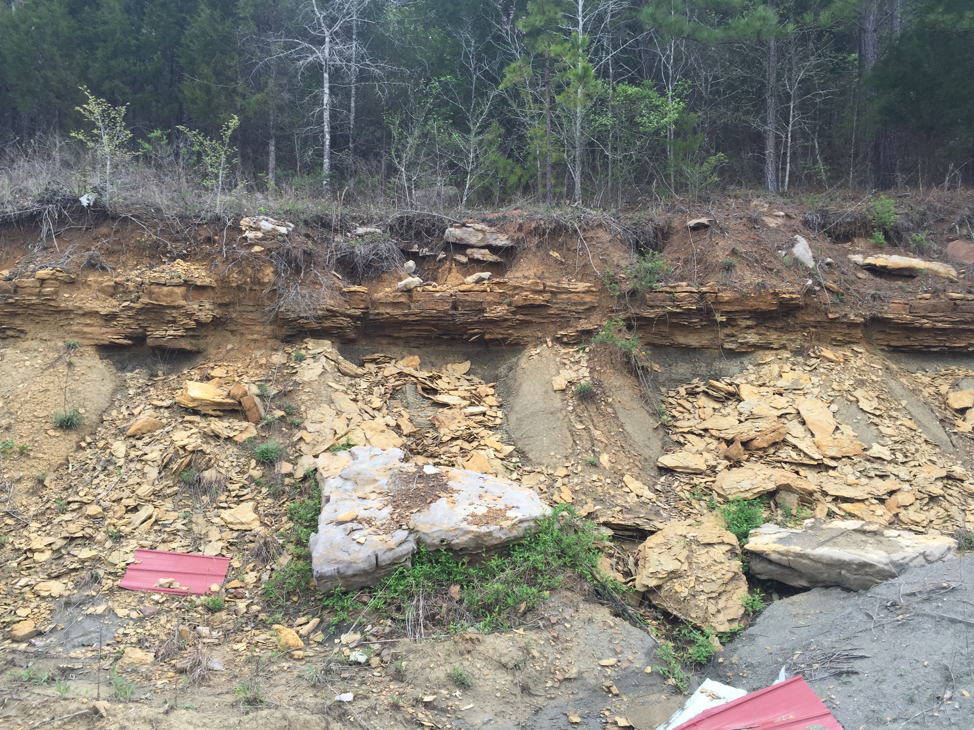
This exposure was accessible from the truck (the dogs were happy) and it showed this remarkable fossile bed, which includes Spiniferid brachiopods, bryozoan calyxes (kinda like spinal disks), and other fossils. I couldn’t get a hand sample of this, however… 
This kind of fossil assemblage is used to know were these rocks fit into geological time. The exposure photo above shows how different these layers appear but the following hand sample photos show how similar they are internally..first, the more massive layer from Big Hill: 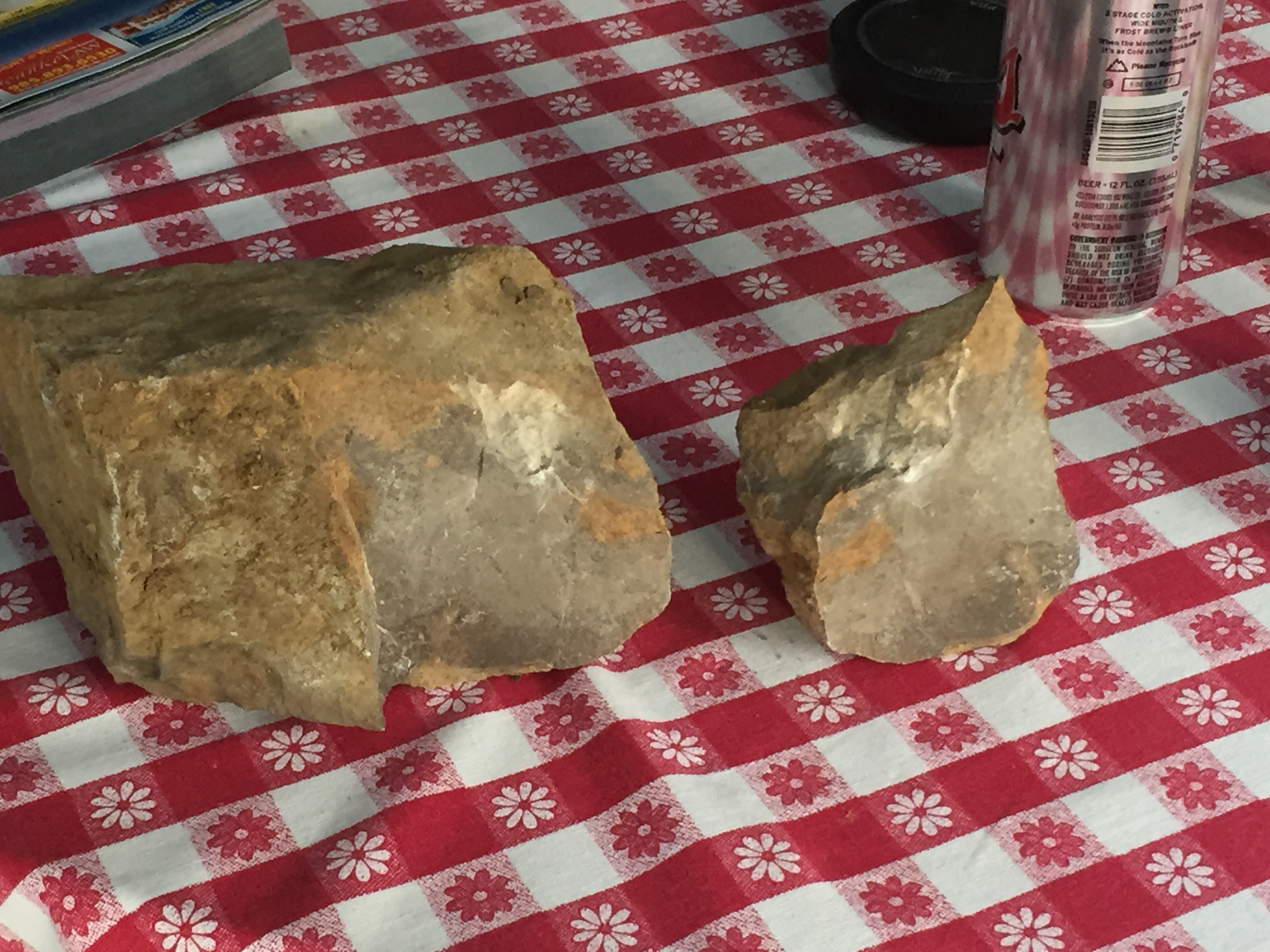
and then the fossiliferous layer from the barn…

Weathering sometimes causes slight differences in limestone mineralogy (calcite) to accentuate fossils against their containing rock, as seen in the photo above with the fossil bed, even though the rock looks the same when broken apart. These limestones are described in the formal description of the Pride Mtn Formation, but what about the shales (i.e. mud)? I didn’t document the change from redder mud (from the overlying Hartselle FM) as I drove down Mountainside, but the mud (i.e. weathered shale) a Big Hill was darker. I will discuss this in the final post from Hawk Pride
A muddy drive down Mountainside: Seeing the Hartsell up close
The USGS briefly describes the Hartsell Fm. in this general area as “Thin-bedded, fine-grained sandstone and greenish-gray shale interbedded with coarse limestone. Thickness 0 to 60 feet.” After returning to HPMORV park, I took a drive down the trail called “Mountainside”, which drops from ~850 feet to ~600 feet elevation. I collected a sample and took some photos, which I will show in this post, along with some (quite different) photos of this formation on the other side of Thompson’s Draw. This image shows my traverse downhill to join “Big Hill” trail.

There is a steep, muddy, drop down the top of the hill on Mountainside but then the trail (road, actually when weather is dry..never!) levels off. I climbed back up “Powerline Cutoff” and took this photo, which shows thin bedding in sandy rocks.

This is a pretty easy climb in the 4×4; the steps are like an asphalt highway for going uphill. The hand sample I collected was not particularly interesting.

I think the original top of this layer is to the left in the photo. It has a reddish (buff…LOL) hue and shows some fine cross bedding. The reddish color suggests that the sediments were deposited above sea level ~320 mya, and the fine layering only occurs in fairly quiet water with rhythmic variations in water depth (e.g. tides) and low energy from waves. I drove a little further (location 2 in the above photo) and took this photo, which suggests an intertidal location because of the lack of wave ripples, and the irregular surface.

I will jump ahead to the drive up the southern flank of Thompson’s Draw, where I found these great exposures of massive bedded sandstone with layers of thin-bedded sandstone with cross bedding. This is where the buggies go…there are trails over this ledge!

This doesn’t quite fit the USGS description, but rocks vary rapidly over short distances. The reason in this case is probably the environment in which these rocks were deposited, and the time interval over which the sediments were deposited. This was a shallow-water environment a lot like the Gulf coast, with lagoons, barrier islands, sand bars, and mud flats. My drive down Mountainside also covered several million years of history, but we cannot date these sediments…we only know for sure that the rocks get older downward…LOL!
Field geology on Hawk Pride Mountain
After rising early and having a camping breakfast of bacon, eggs, and mixed fruit, I set off for the type-locality of the Pride Mountain Formation, which I passed as I arrived at the park. This location is shown in the prologue to this trip. It was easy to locate and I collected some hand samples and took some photos. Here is the official description, which is a compendium of multiple field efforts…needless to say, I didn’t see all of this!

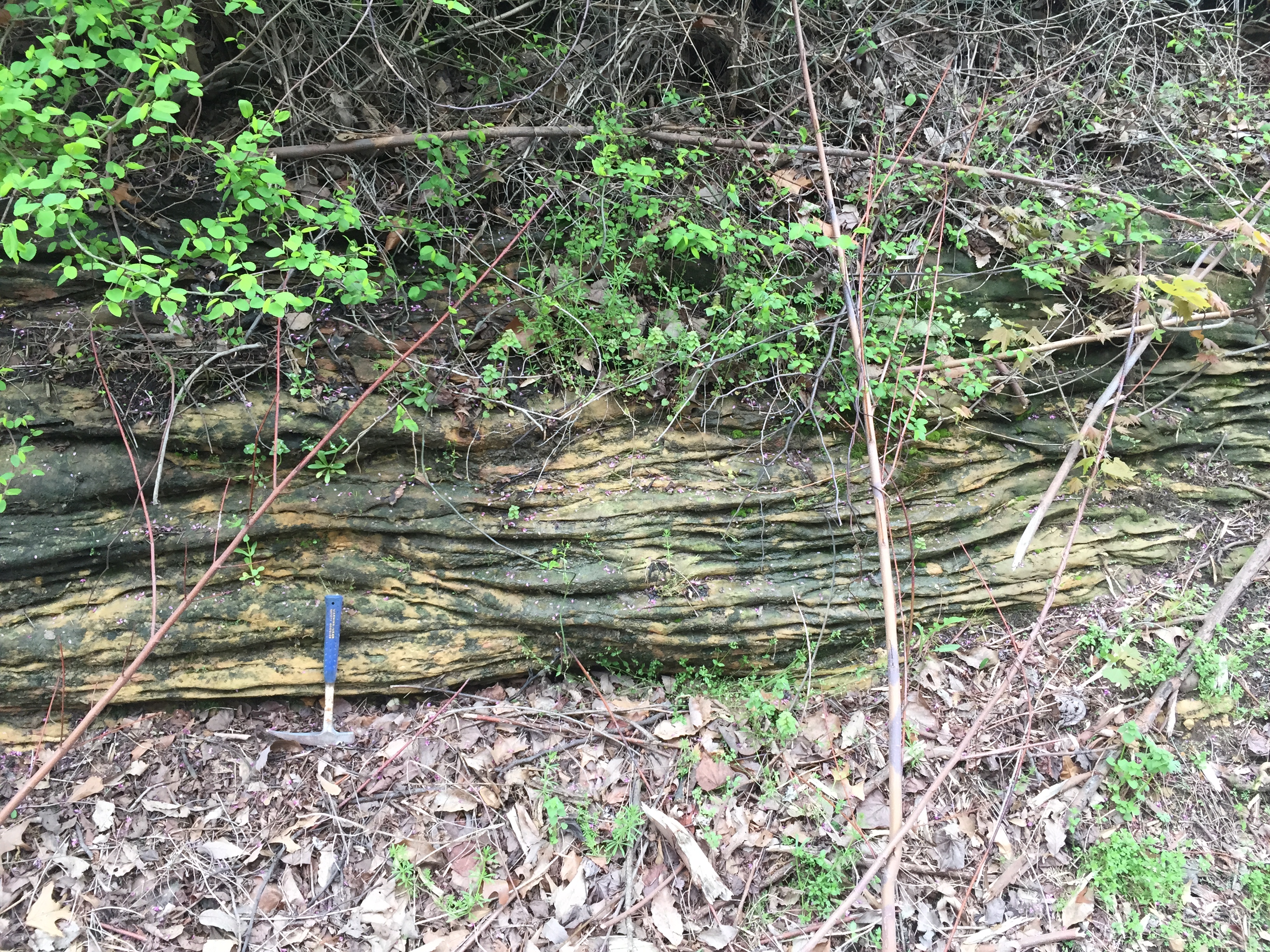
What I did see was dark soil that had eroded from the shale layers within the Mpm (Mississippian Pride Mountain Formation) and sandy layers with both massive and fine layering with cross-bedding. Here are some good images of these features.
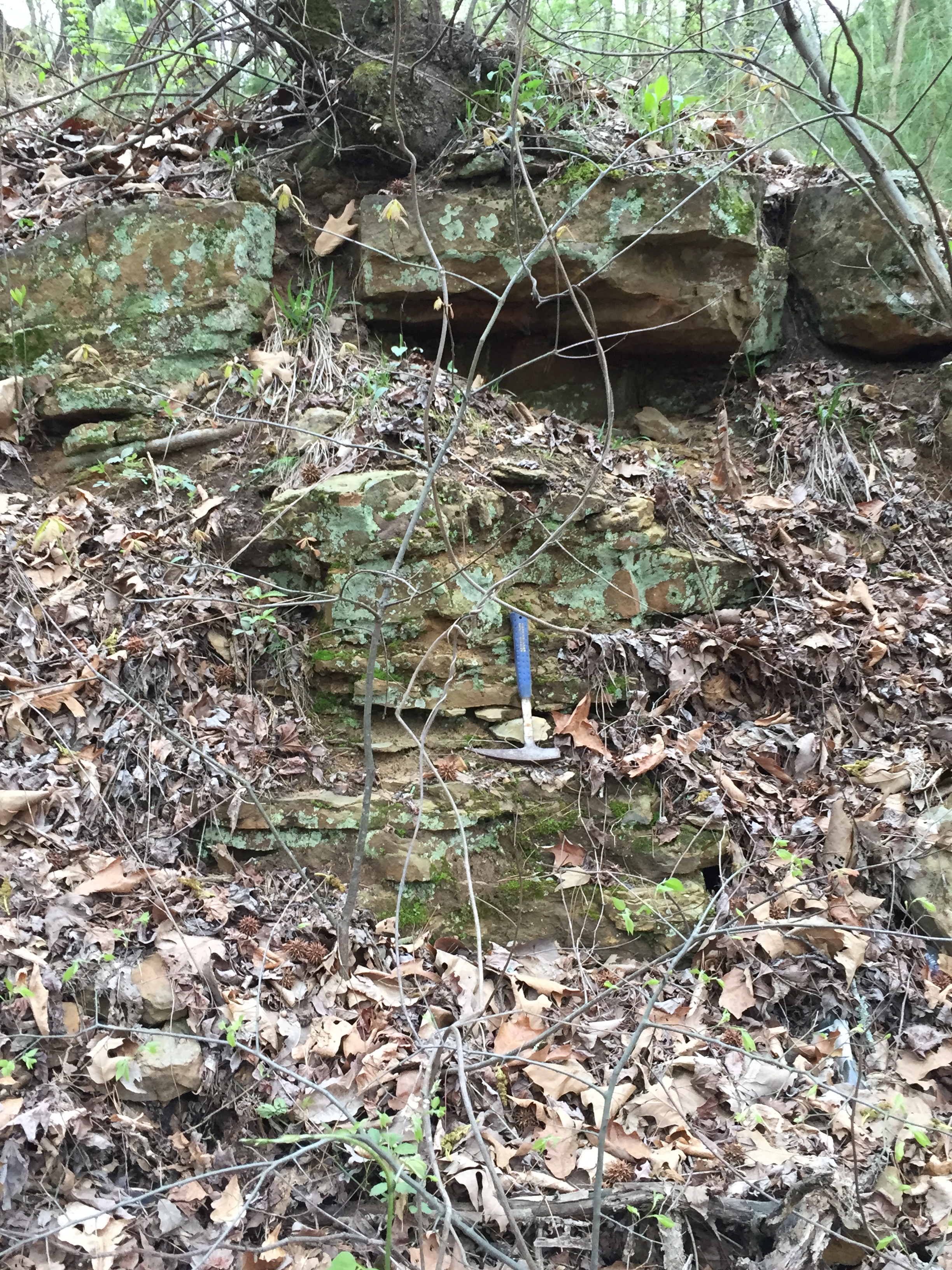
This is a typical shot of the thick beds, but they were not continuous even over 100 feet along the road cut. The next photo shows the cross bedding in thinly bedded sandstones.
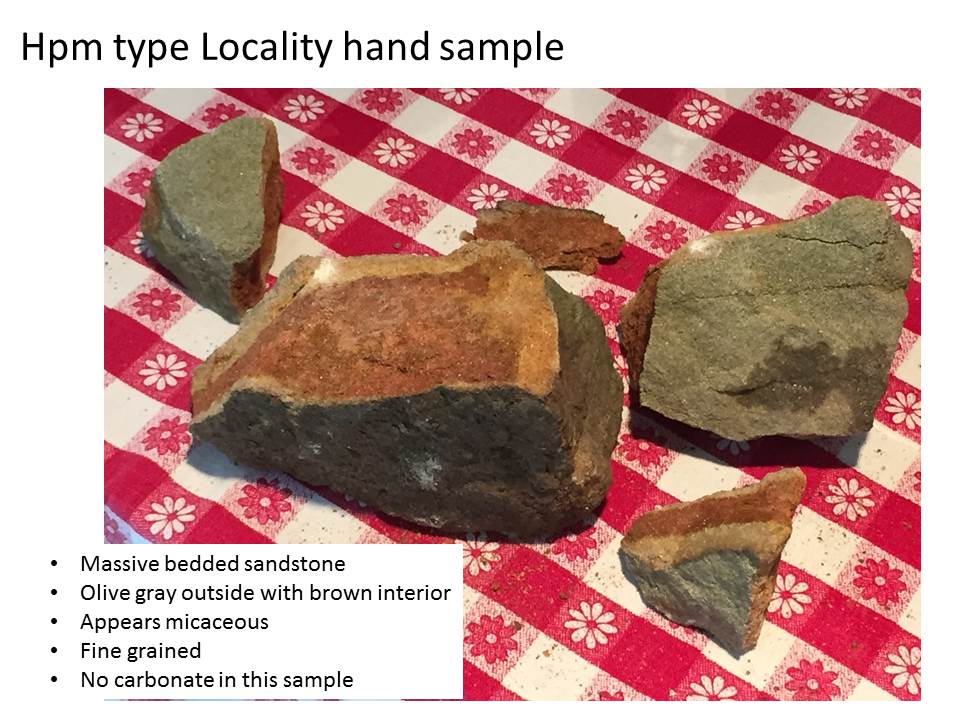
The bedding surfaces (assumed to originally be horizontal) dipped < 5 degrees in a northerly direction. There was no reaction to HCl (weak acid) at this location, so any limestone was either buried by shale (soil) or not present. I collected a hand sample and brought it home for more detailed examination (sounds good, right). The outside was olive colored but the interior is a brown as in the formal description (above photo), and I saw flecks that are probably mica of some kind (i.e. micaceous). Mica is a flaky mineral that reflects light easily.
My next post will move back to the park and the field relations of this formation (Mpm) and the overlying (i.e. younger) Hartsell (Mh)…
Hawk Pride Mountain Off-Road-Vehicle (ORV) Park
After crossing into Alabama and driving north thru Mississippian (~360-323 mya) sedimentary rocks, I arrived at Hawk Pride ORV park. I set up camp on top of the Upper Mississippian Hartsell Sandstone (Mh hereinafter) as seen in this image.
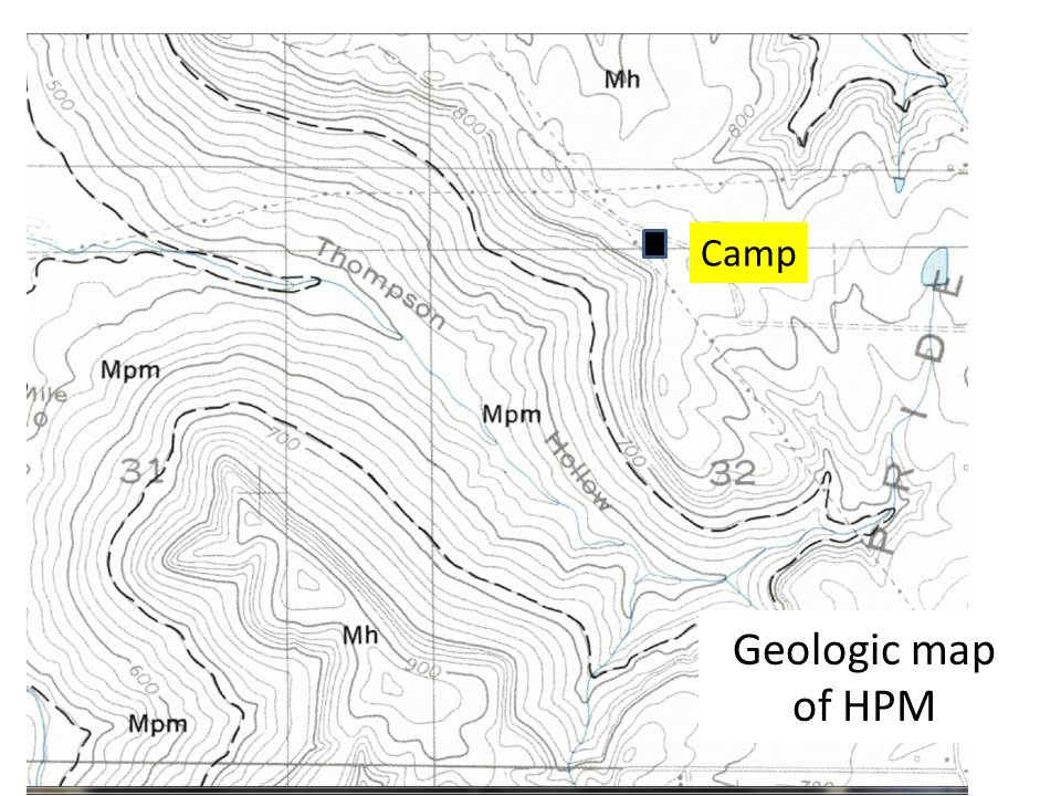
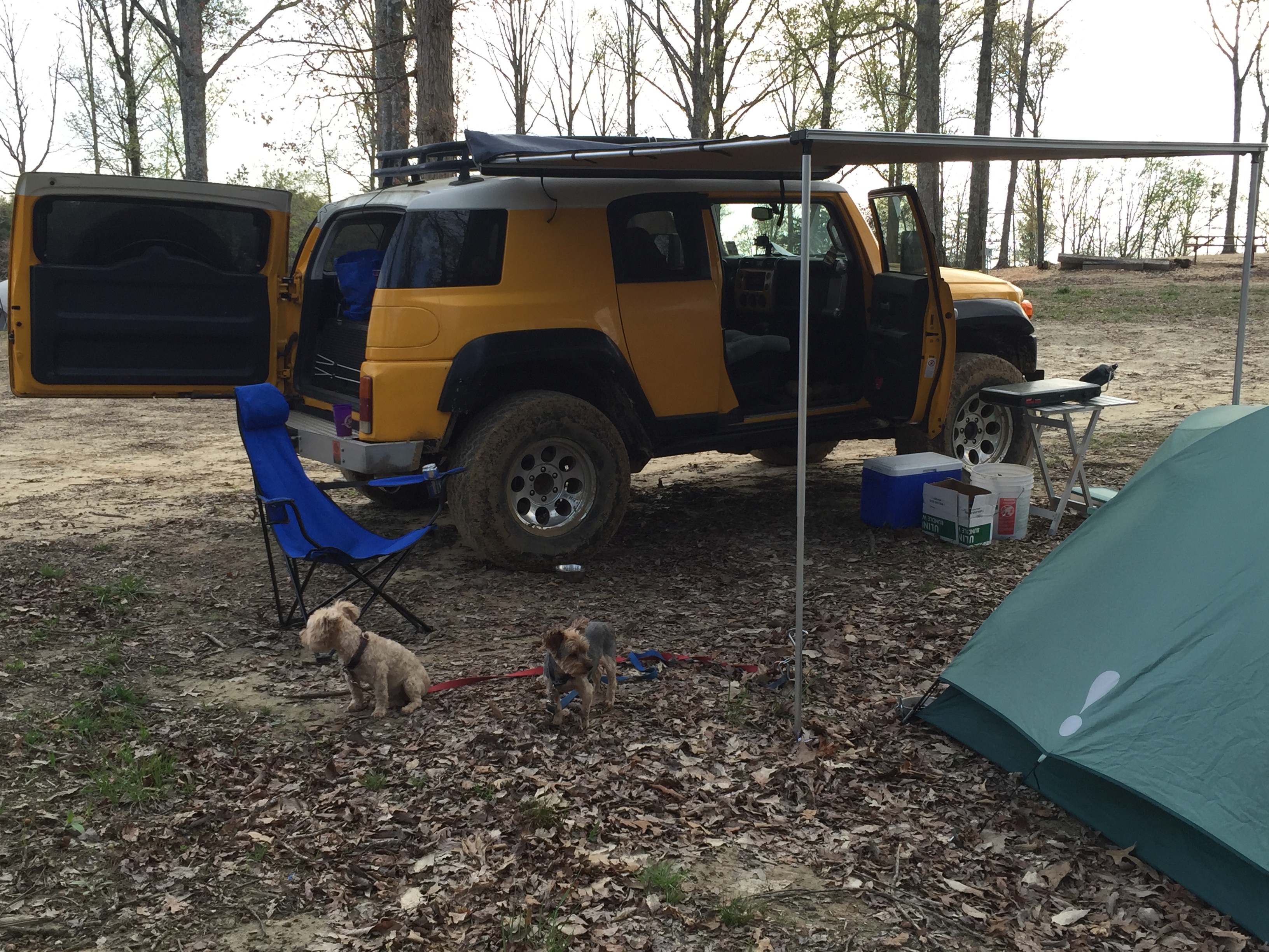
I will discuss this rock formation more in a later post. I set up my tent and had dinner before retiring early for a day of geology in the morning.
A day’s drive back 330 million years
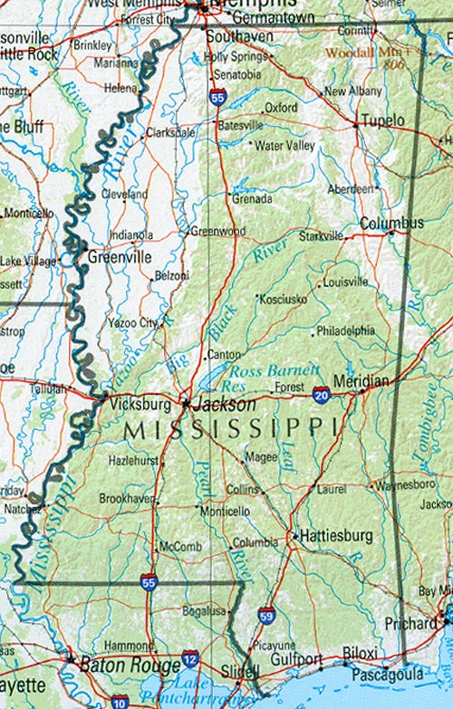
Today’s post is actually from April 8 but I had to get back to do the necessary reading to make it useful. I drove up on Wednesday before the Mardi Krawl event began to have a fresh start the next day, and took the usual route up I-59 through Mississippi before heading north on US 45 at Meridian, MS. This is a leisurely ride from the coastal plain of Louisiana through the pine hills of SE MS, into the Jackson plain, the north-central hills, Flatwoods, black prairie, and the Tombigbee hills (MS History Now) before crossing into NW Alabama. As these regional names suggest, there is something going on that produced hills and prairies in what we think of as a hilly state. I enjoyed learning at least part of the reason why on this trip.
This map of the regions will help in following along. I crossed the Pearl River (still in LA) and immediately began climbing as I drove over Miocene (~23.3 mya) mixed sand and clay sediments on my way to Hattiesburg, MS. The forests were indeed pine woods just like on the coastal plain. There is an unconformity that only careful geologic mapping can identify between these rocks and younger Pliocene (~5.2 mya) sand and gravels. Note that a change from sand and mud to sand and gravel implies that the source of the sediment was closer (i.e. gravel doesn’t travel far in a river). As I approach Laurel, MS, the sediments no longer include gravel.
At this point, my journey through time becomes disjointed because of erosion, which produces unconformities. This erosion results from many processes, including uplift of the crust and changes in climate but I am not going to worry (yet) about that! As I continue traveling up I-59 to the NE, I pass over another missing time period and encounter Oligocene (~35 mya) limestone (somewhat stable ocean) and volcanic ash…volcanism implies uplift usually. Then a lot of sediment is missing when I find myself in Eocene (~56 mya) clay and sand, which suggests a low-energy ocean like the Gulf Coast today. After yet another time interval of erosion, I am driving through older Eocene laminated clay (very calm water) and have a respite from all of this erosion to go back in time to nearshore sandy beaches, until the oldest Eocene sediments are reached after a brief erosional episode…these are fine sands, sandy limestone, and lignite (a burnable organic material, aka brown coal).
I leave I-59 at Meridian, MS, and turn north on US 45, and soon find myself missing time again before driving over Paleocene (~65 mya) sediments containing sand, kaolinite (a pure clay mineral) and clay with bauxite (suggesting a tropical climate…most bauxite today is mined from South America). These (tropical?) sediments are preceded (remember we are going back in time) by clay with sand lenses, like the northern Gulf of Baja, i.e., sand bars on a muddy coast. But then, I drive a little further and a lot of sediment is missing…now I am passing through Cretaceous (~145-66 mya) chalk and chalky sediments. After yet another disruption in my time travel schedule, I am driving over Cretaceous nearshore sediments that include sand, limestone, and chalk (very calm water). At this point I enter Macon, MS, and thankfully drive through slightly older chalk before encountering another missing time interval.
The Cretaceous rocks north of Macon are nearshore sands and clays that suggest tides and waves (e.g., the east coast with its bays and mudflats). Then I arrive in Columbus, MS, and see these nearshore rocks for a while before smoothly passing into clay, then sand, and then gravel before hitting another unconformity. I crossed the AL state line about now and these (fairly) uniform sediments are replaced by Mississippian (~360-320 mya) sediments…I am in NW AL and a more continuous (although older) time interval.
I am not qualified to reconstruct the geography of Mississippi during this ~320 my (million year) interval but I will try anyway because this is not the real reason for my road trip…to go wheeling! I will start at the oldest rocks I encountered in MS/AL, the Mississippian limestones and nearshore sediments. This was an environment not too different from the U.S. east coast today. The missing 175 million years were caused by the erosion of the ancestral southern Appalachian Mtns, when Africa said HELLO to N. America. These mountains must have been huge, like the Himalayas today and not continuous like the Andes, which resulted in different erosion/sedimentation at every location along their front (towards the central U.S.). Eventually, they wore down enough that the erosional products (i.e. sand and gravel) were not themselves eroded. These sediments are seen near the MS/AL border near Smithville, MS.
A stable ocean (i.e. marine) environment did occur and was preserved in the nearshore sediments near Columbus, MS. All the while there were changes in sea level and adjustments in the earth’s crust that led to periodic episodes of erosion, resulting in some of the observed unconformities. The presence of chalk, which results from the quiet accumulation of algae-like plants, indicates stability for long periods of time. In the late Cretaceous, however, there was an uninterrupted shoaling of water depth and a coastal ocean returned (for a while). The sediments then oscillated between these coastal sands and limestones and land-based sediments like lignite and bauxite. All this time the land-mass was shifting northward from the equatorial climate indicated by the bauxites in the Eocene.
Just when all seems set, volcanism began (bentonites are the clays that come from ash layers) even while a quiet ocean was present in MS, as indicated by the limestones near Meridian, MS in Oligocene time. The presence of land-based (i.e. terrestrial) sediments in SW MS during later Eocene (~40 mya?) suggests that equilibrium was approaching this area. The large number of unconformities, however, indicates that erosion was still in charge, as it is today along the entire southern Appalachian Mountains and their descendent plateaus, like the one I will be visiting.
I would like to relate these geologic episodes and their resulting sediments to the geographic provinces identified in MS. This is a difficult task but I will try from the oldest (i.e. NE MS) to the youngest (SW MS). This can be easily accomplished by overlaying the MS geologic map on the geographic province map using GIS software, which I don’t have. The Tombigbee Hills are coincident with the Cretaceous nearshore sediments near Smithville, MS; sands resist erosion better than clays. The Black Prairie is consistent (a wishy-washy scientific word) with the unconformity just SW of Columbus, MS, and that would also explain the Pontotoc Ridge because a pure sandstone layer (like the nearshore sands of late Cretaceous) would be resistant to erosion. Chalk doesn’t weather well and a layer like that between Macon and Columbus would result in a flatter landscape like the Flatwoods.
The North Central Hills province is consistent with irregular erosion of mixed sandy-muddy sediments like those between Macon and Meridian (Paleocene) whereas the Jackson Prairie could be the result of erosion of the mostly muddy sediments (and volcanics, which erode rapidly) that were deposited during the Eocene between Meridian and Laurel, MS. The Pine Hills are another product from irregular (aka heterogeneous) erosion of sandy sediments.
And of course we shouldn’t forget that the earth’s crust is sinking along the Mississippi River for uncertain reasons, causing all of these layers of sediment to dip to the west. You can see my previous post about this.
Mardi Krawl 2015: Prologue
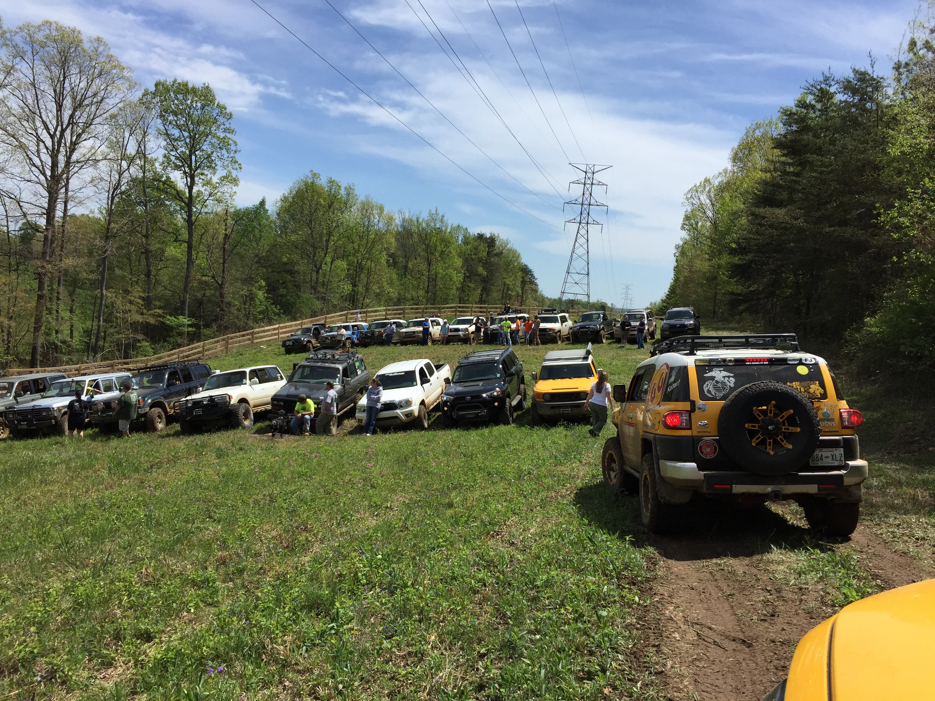
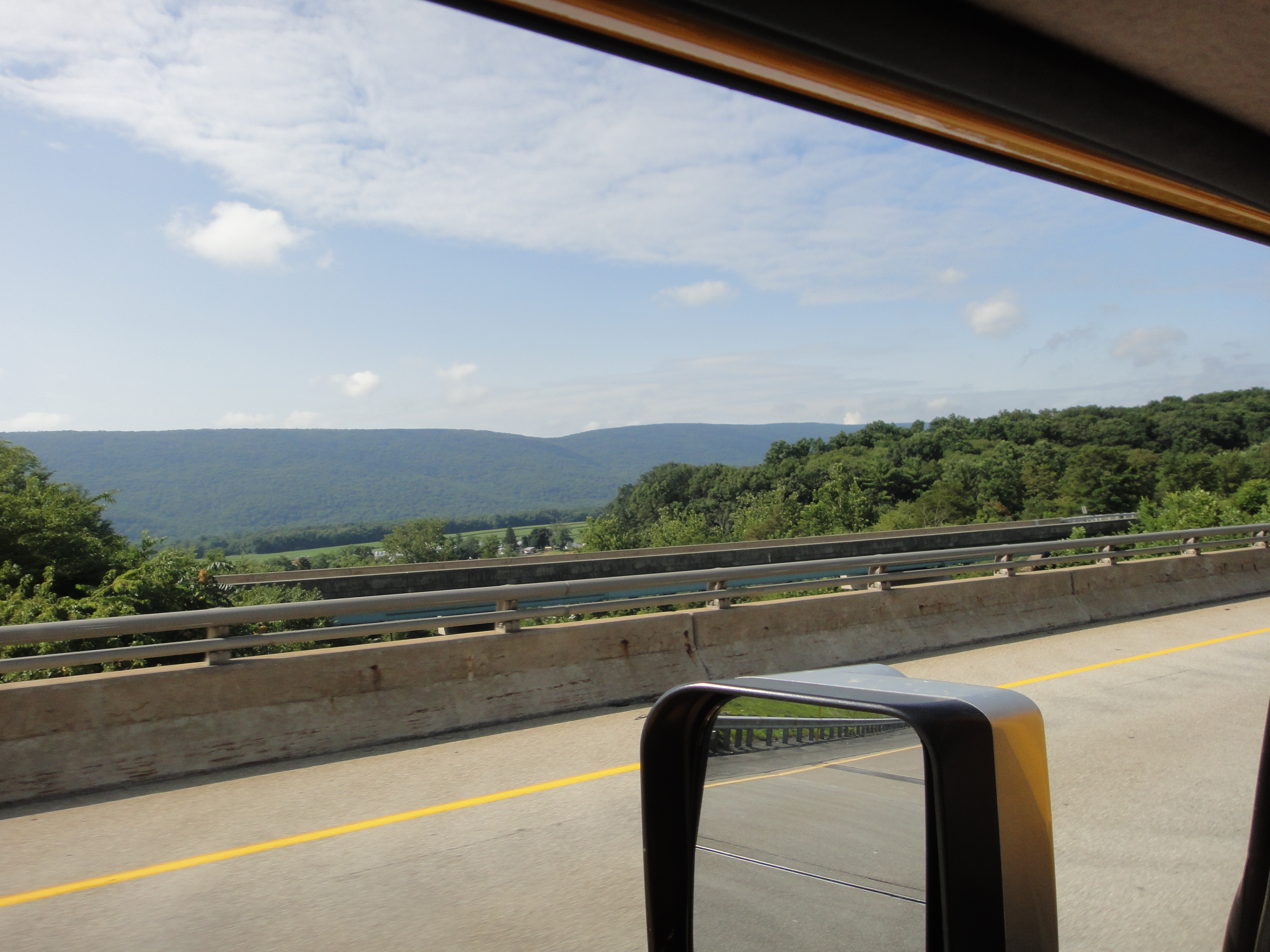
It has been a few months since my last post but I am leaving tomorrow for a return to a favorite southern Off-Road-Vehicle (ORV) park, Hawk Pride Mountain ORV Park, near Tuscumbia/Muscle Shoals, Alabama. It is time for the Louisiana Land Krewsers annual event, the Mardi Krawl. We really get excited about rocks down here Nawlins’ way! It is a seven-hour drive, which is also interesting as we climb from the pine barrens and wetlands of the coastal plain, sandwiched between the Mississippi River Delta and the Pearl River, which drains central Mississippi, into the low plateaus of the southern Appalachians (~800 feet elevation). This post introduces the geology of northwest Alabama as it will be experienced while wheeling in the private park.
The map below shows where we are headed way up north in Alabama. I call the park area the “Study Area” because this is the first time I have an objective and plan to use geologic mapping methods to collect data to be published on this blog. The objective is to find out why the “easy” route up the main park hill is impossible to climb when it rains…it is unbelievably muddy whereas the other side of the hollow is sandy and traversable. I will spend Thursday collecting data about the difference in the rocks (and thus traction) on opposite sides of the valley. I am using basic geologist tools: a description of rocks from this region (Alabama Geologic Survey Circular 140); a 7.5 minute topographic map from USGS; rock hammer; weak hydrochloric acid (i.e. pool acid); a geology compass on my IPhone…I hope, but with a backup home-repair inclinometer and cub-scout compass; antique 10x eye glass (tiny view for individual minerals); and binoculars.

I couldn’t find a real stratigraphic chart for this area, where the exploitable resources are deep underground, so I pieced together this VERY schematic stratigraphy from the AGS 140.

I am going to be focusing my attention during this trip on the Pride Mountain Formation (hereinafter PMF), which has its type locality (i.e. place where it was first described) very near the park. I am going to visit this site because it is located on Hawk Pride Mountain Road, which is how I will drive to the park…easy! I used township-range info from Alabama to find the approximate location, and the description from AGS-140, to find where to look for these exposures.
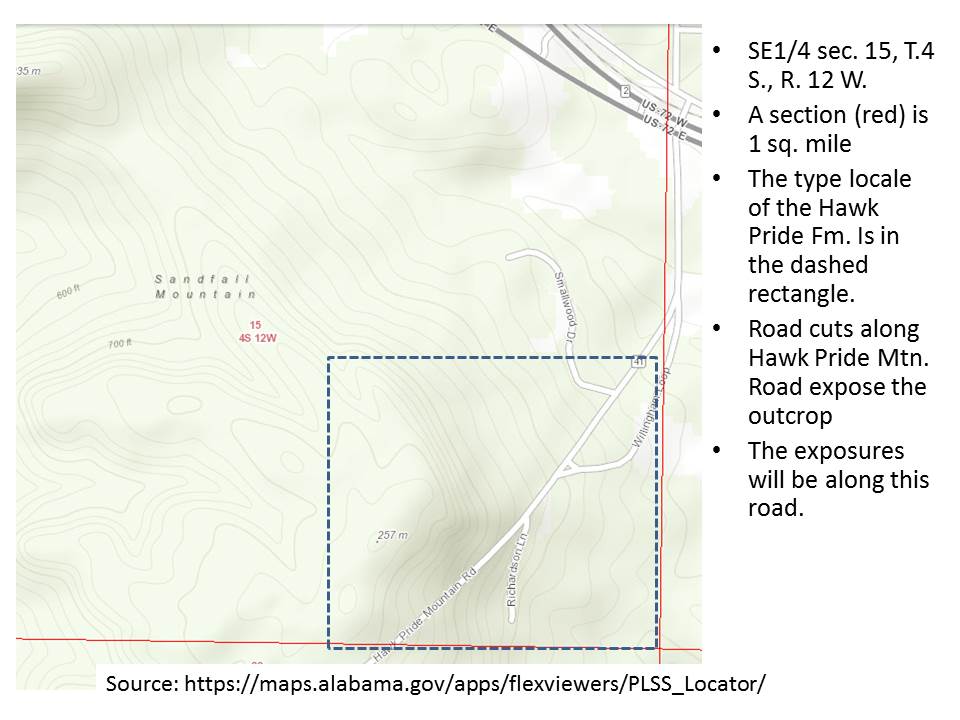
The type-locality is very close to the park (a couple of miles) and it is likely found there as well. The topographic map below shows the proximity of the type-locality and the park, as well as the general topography of the area. This is an erosional terrain and significant faults are probably not present, but we will see! Only the northern end of the park is outlined in the image.
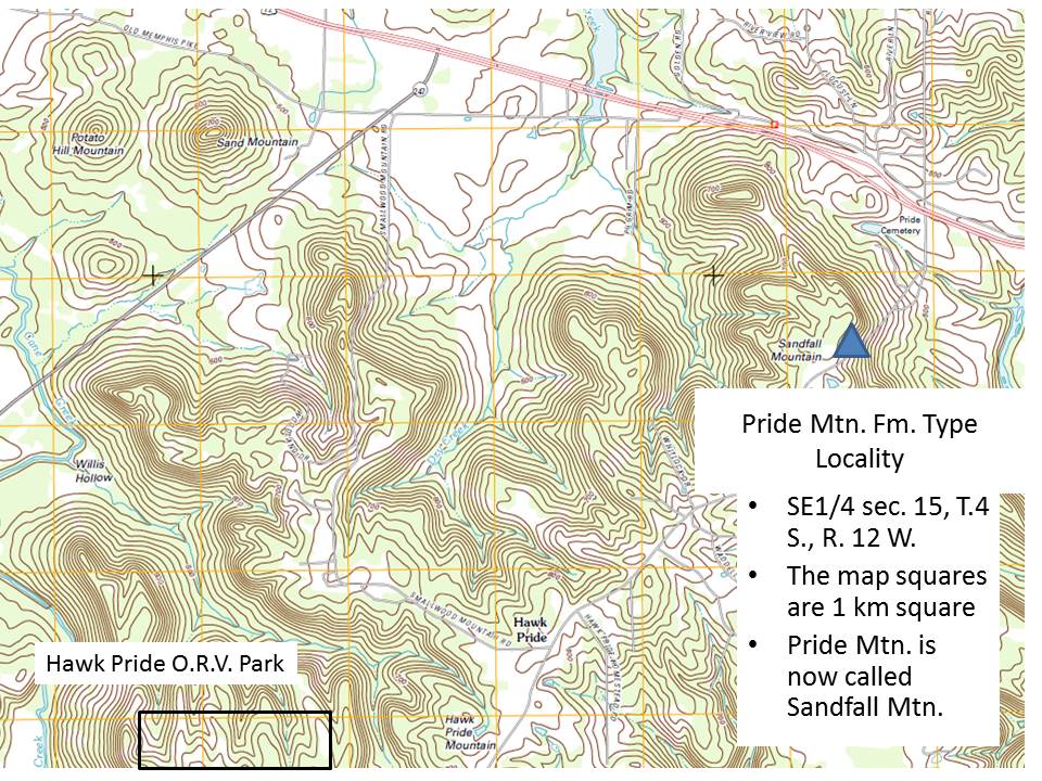
I will be collecting typical geologic data: strike and dip; lithology; and fossils, where they occur; on both sides of Thompson Hollow (see figure below), in order to discover if the shales of the PMF are not as prevalent on the south side of the park.

With these data I hope to identify the formations and any unconformities between them that will help me understand why this park is so difficult to escape when it rains.
Coal Mine Classic: Epilogue
I left Twin Grove campgrounds on Sunday morning and took a detour along US-322 to State College in order to visit my advisor from Penn State, and thereby crossing the Valley and Ridge province from east to west. The rocks of the Pottsville Group are Pennsylvanian age (~320-300 mya), but the rocks get older as we travel westward. This is one of the most beautiful drives I have done, as we follow the Juniata River where it has followed weak points in the crust.
I stopped at a large road cut and collected my Texas-sized hand sample, which is a Devonian period (~420-350 mya) sandstone with a green hue and a combination of striations and minerals that indicate it has been subjected to a large stress from faulting. The texture and color indicate a nearshore marine depositional environment, like a modern beach or shallow water near the coast.

These rocks are exposed in the west because of sliding along deep nearly horizontal faults when Africa collided with N. America, which pushed deeply buried rocks like this westward during which they slid along more vertical faults. This trend continues until we get to Arch Rock, where Silurian period (~445-420 mya) thin sandstone and shale beds are exposed in road cuts. These small folds are superimposed on much larger ones.

The exit to Arch Rock gives a nice view down the valley to the west. The ridges are oriented more to the NE in this location. As we travel westward, they become more north-south.

Finally, we cross the pass at Seven Mountains and drive down into Nittany Valley, which has perfect Ordovician Period (~485-445 mya) carbonate (limestone and dolostone) that are tilted about 30 degrees. Thus, during my two-hour drive I have traversed ~200 million years of sediments, and gone from river/stream sand/shale/coal sediments to the deep sea limestones that were disturbed by the Appalachian Orogeny. And it was all visible to the naked eye!

Recent Comments