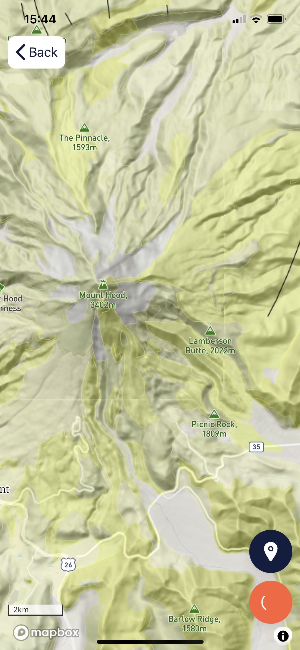
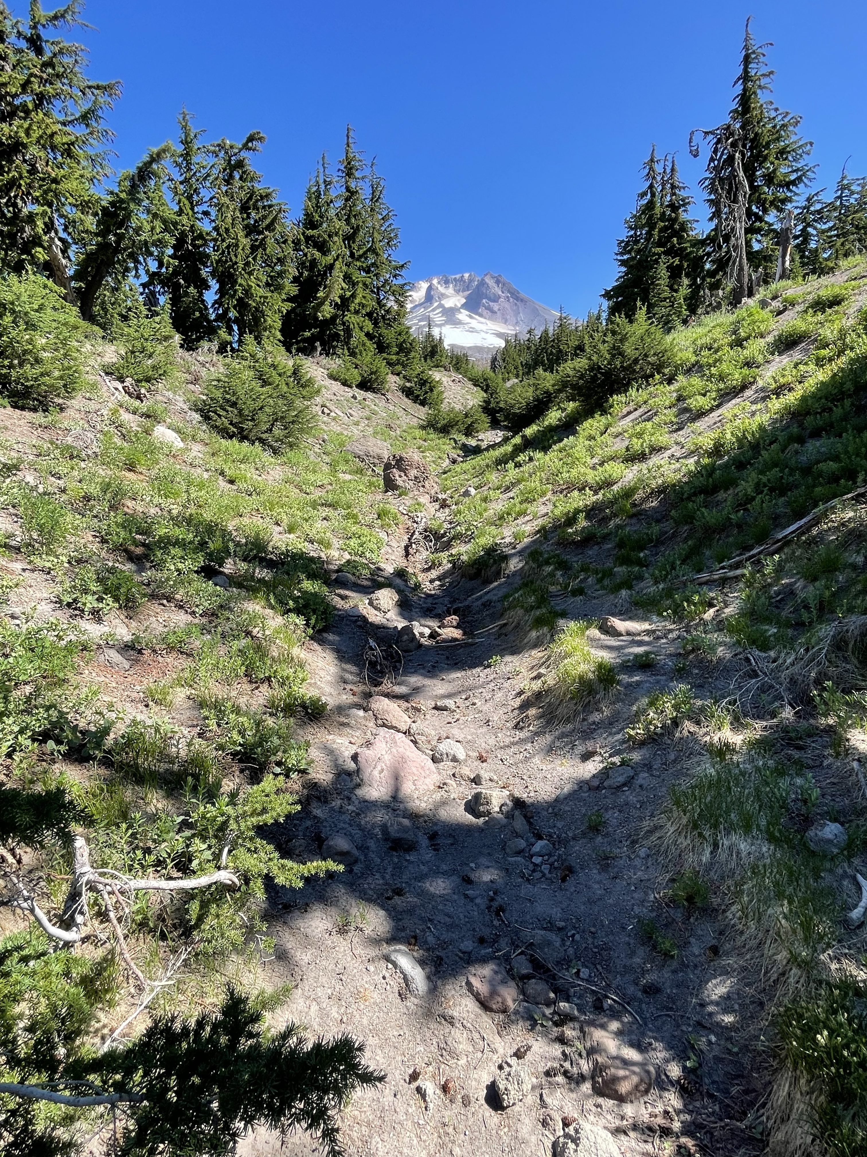
Figure 1. This is Mt. Hood seen from the south. The peak is about about 11,240 feet and this photo was taken from an elevation of 6000 feet, at the Timberline lodge. Several eruptions and collapses have occurred in the last few millennia, leaving the summit asymmetric. Note how the left side appears to be missing. Material has been transported/erupted down the slope towards the camera. The near-field shows two ridges constructed of debris transported as fluidized sediment, carrying huge boulders as well as sand and even ash down the slope in a series of tongues. These deposits are called lahars. Note the wide range of sizes of material near the camera, some larger blocks are still angular while others are rounded. The lahar sweeps up everything in its path but is limited in extent.Figure 2. Geologic map of Mt. Hood from RockD. The study area was along the slope near the closed path to the left of center in this map. Note the linear ridges originating at the summit. These are lahar deposits (pyroclastic and debris flows), colored in pale yellow-green. The darker shades are ash and lava with a composition of andesite and Dacite (extrusive igneous rocks low and high in silica, respectively). The underlying magma chamber was long lived (tens of millions of years) and evolved chemically. Figure 3. This image of a typical boulder is about one inch across. It has a very fine matrix with angular, light-colored crystals that are probably feldspar and quartz. The large one looks like quartz to me, which suggests that this particular sample is Dacite. This was blown out of the volcano and later eroded, rolling down the hill and becoming part of a debris flow. These phenocrysts were probably torn apart during an eruption and trapped in red-hot, fine ash as volcanic bombs near the summit.Figure 4. Photo of the linear channel between two debris flow ridges. Note the presence of vegetation on the slope, including trees. It takes a few centuries or longer to form soil for plants to grow in. The scene in Fig. 1 is very different, with sparse vegetation. Look up the channel and you see the summit; it was a straight run downhill for the lahar. Figure 5. This photo shows the termination of a lahar as well as any other; they run out of momentum and stop without flowing out like water, because of their high viscosity. This has been occurring for millions of years, so the entire region on which Mt. Hood rests consists of subterranean flows like these, one piled on top of another; lava, ash, mud … repeat. A careful examination of Fig. 2 will show that the ridges radiating from Mt. Hood often end in bulbous terminations. Erosion has softened their morphology somewhat.
Summary. Understanding volcanic stratigraphy is easy with a simple exercise. Spread your left hand out on the table, fingers apart. Each finger is a volcaniclastic flow, either pyroclastic, lava, or a lahar, separated by hundreds of thousands of years. Now, lay your right hand over the left but not with the fingers aligned. Imagine doing this hundreds of times, while peeling away the tops of your fingers randomly (i.e. erosion).
Remember the violent eruption of Mt. St. Helens? It was a pyroclastic eruption (mostly red-hot ash) but what made it destructive was the boiling hot mud encasing boulders of older volcanic material. The blast flattened the trees for miles and the lahar cleaned up the debris.
Imagine such an eruption occurring every year … thank god they are separated by centuries or millennia.
There’s only so much energy available, even for the dynamic earth …


Trackbacks / Pingbacks