
Colorado’s Turbulent Past: Tertiary Intrusive Rocks
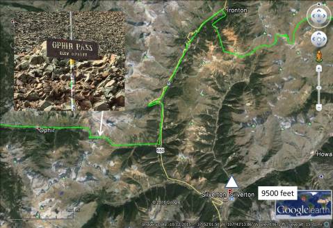
We camped along a creek in Silverton across from a silver mine and mill, as shown in this satellite image; the mill is indicated by a white triangle. The mine and mill are now open for tours but I didn’t have the opportunity to visit them.
Here is a photo of the mill. The mine went into the mountain behind the mill, which appears to be a fault. Veins of silver and gold are frequently found along faults, which are weak lines in the crust where the high-pressure fluids can penetrate. Silverton was settled in 1874 and had a peak population of 5000 in the early 1900s. The mill is nestled against the ridge south of town.
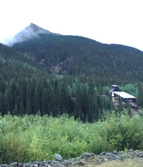
Gold and silver milling technology was changing rapidly while Silverton was active but this mill probably first used an “arrastra” method with a horse (or maybe water power) to drag a heavy stone around a central post to crush the ore brought from the adjacent mine shaft. Water and chemicals like mercury would have been mixed with the crushed ore to form an amalgam (silver/gold plus mercury), which was heated to boil off the mercury. It is likely that this inefficient method was replaced with a Comstock mill, which used a heavy piston to crush the ore and a cyanide process would have been used to extract gold more efficiently.
After leaving Silverton, we headed west toward Ophir Pass (see photo above) where the landscape changed dramatically. This photo shows the view looking west from Ophir Pass; note the lack of vegetation in this rocky terrain. It would be extremely difficult for trees or shrubs to take root, or for lichen to grow on these constantly shifting fragments of the original volcanic rocks. It is noteworthy, however, that grass is growing at this same elevation in the background where the rocks are not as fragmented.
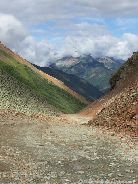
Note also the muddy matrix supporting the trail, which implies that these rocks contain minerals that weather rapidly to form clay, i.e., these rocks comprise much more Ca-bearing feldspars like plagioclase rather than the K-feldspars we saw early in our journey, which form gravel. This next photo shows that these rocks are very resistant to erosion where they are less fractured.
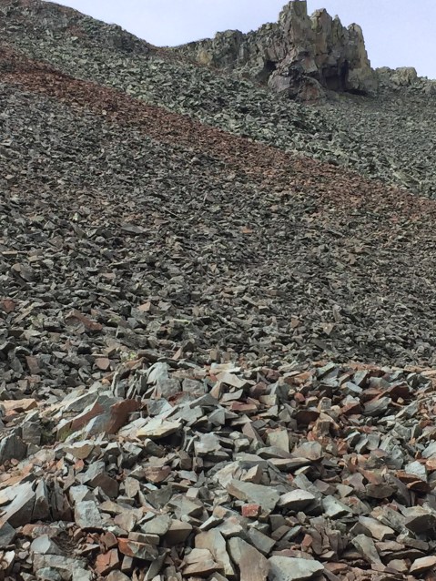
As an aside, this kind of scree is impossible to climb in a wheeled vehicle, and off-roaders avoid it like the plaque. There is no cohesion amongst these fragments and our tires just churn it up like water from a paddle wheel; of course, with enough horsepower and large enough tires it can be climbed but not consistently.
A close-up view of one of the larger fragments shows that this rock can be classified as an andesite porphyry.

The lighter colored cobble is a piece of host rock and not a mineral crystal. Zooming in shows many smaller particles of rock (not mineral) and an irregular surface texture that suggests a squeezing of the ash as it was deposited from the air and compressed as it cooled.
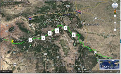
We continued traveling eastward until we encountered some sedimentary rocks containing sandstones and layers of coal. I have no photos of these formation however, but according to the USGS geologic map these are Cretaceous (85-60 mya) Mancos Shale, a nearshore marine deposit with coal beds, which probably contributed to the naming of Black Mesa. We chose a camp site among the Tertiary intrusive rocks as indicated by location 6 in this image.
Our campsite, among spruce and aspens, was apparently used by hunters and boy scouts. Here is a photo that includes a generic hand sample of an andesite and a 15x photo of a sample from our campsite.
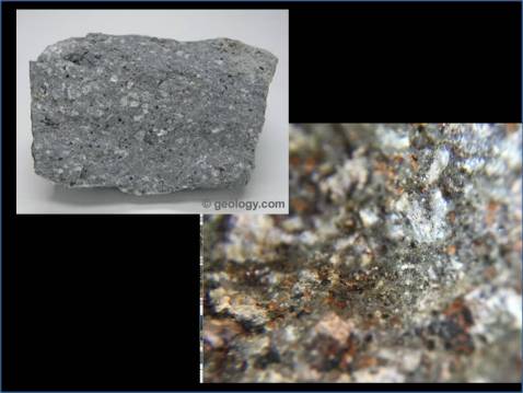 The rocks (there were no exposures where we stayed) looked like this andesite porphyry from geology.com. The larger photo shows that the hand sample color of grey is probably caused by the areas of grey glassy material, which are not likely to be quartz as in the granites we saw earlier because quartz is not present in intermediate igneous rocks like this. The best general reference to understand the rocks where we stayed is the Roadside Geology of Colorado, suggests that intermediate intrusive magmas penetrated into the thick sequence of volcanic rocks to form diorite with unusually small grains because of rapid cooling so near the surface.
Here is another 15x photo of this rock from our campsite. This is a 15x magnification of a rock fragment at location 6.
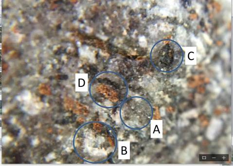
If this hand sample had been light colored, the area indicated by circle A would be reasonably interpreted as quartz, as we saw in the sample from the Wet Mountains and the Sangre de Cristobal Mountains. However, the overall grey color of the sample, and the evidence of crystal terminations in A suggests to me, as a field geologist, that these are actually plagioclase feldspar with more Ca than Na (i.e. the more Ca the darker the plagioclase). Circle B is focusing on the white crystals that, though small, are clearly crystalline and not glass. These minerals are interlaced with the darker crystals and thus I interpret them to be a more Na-rich plagioclase feldspar (Na and Ca plagioclase form a continuous spectrum in this mineral). Area C shows a crystal of a dark mineral with much smaller crystals embedded or adjacent to it. I cannot tell if this is pyroxene or amphibole (a pyroxene-like mineral with water included in its crystal structure) but both contain Ca as well as Mg (magnesium). The most ambiguous (to me) mineral is indicated by circle D, which highlights an orange crystal; we saw pinkish to orange K-feldspar in the Proterozoic granites from the Wet Mountains but there should be no potassium in an andesite. However, some combinations of Na and Ca in the plagioclase series are this color and it is reasonable to assume (lacking thin-section analysis) that this is another phase of these common minerals.
If we estimate the composition of this sample as we did for the granites discussed in a previous post, we get the following: Ca-plagioclase = 50%; Na-plagioclase = 35%; mixed-plagioclase = 10%; amphibole = 5%. The fact that we can see crystal structures even in the smallest minerals in this sample suggests that this is one of the rapidly cooled diorites from the area rather than an andesite (volcanic), which would not have visible crystals at less than 100x magnification (e.g. under a microscope). The grey areas, in other words, are not glass by very small crystals formed near the surface.
We see the end result of this in the following photo of a local muddy area, where it was almost impossible from sliding sideways into the ruts.

As mentioned in previous posts, minerals containing Ca weather rapidly and produce by-products like clays that form MUD; however, as we saw later in our travels, when these clays form a veneer over subjacent regolith, they can be negotiated with care.

Recent Comments