
Snoqualmie Falls: Eocene Volcanism in the Cascades Subduction Zone
INTRODUCTION.
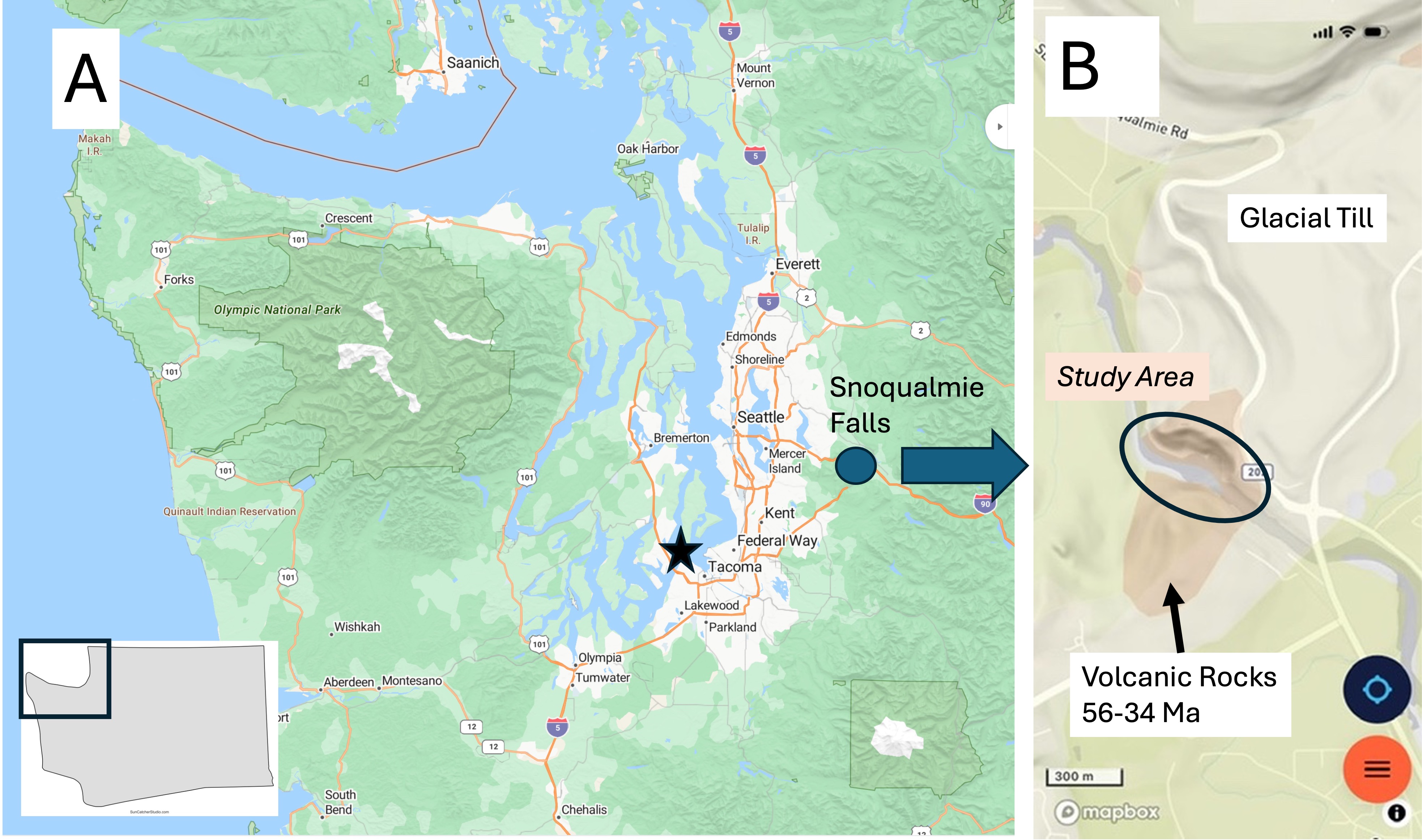
Figure 1. (A) Snoqualmie Falls is less than an hour from Tacoma, in the foothills of the Cascades Range of volcanic mountains. (B) The geologic map doesn’t show much besides glacial till, except around the falls (circled). I recently discovered that the Cascades is one of the youngest mountain ranges in the world, and it includes many active volcanoes that are part of the Pacific “Ring of Fire.” Most of the volcanic rocks were erupted from fissures and small volcanoes during the Eocene epoch (56-34 my ago). The active volcanoes (e.g., Mt St Helens and Mt Rainier) are less than a million years old, reflecting renewed magmatism at depth.
Observations
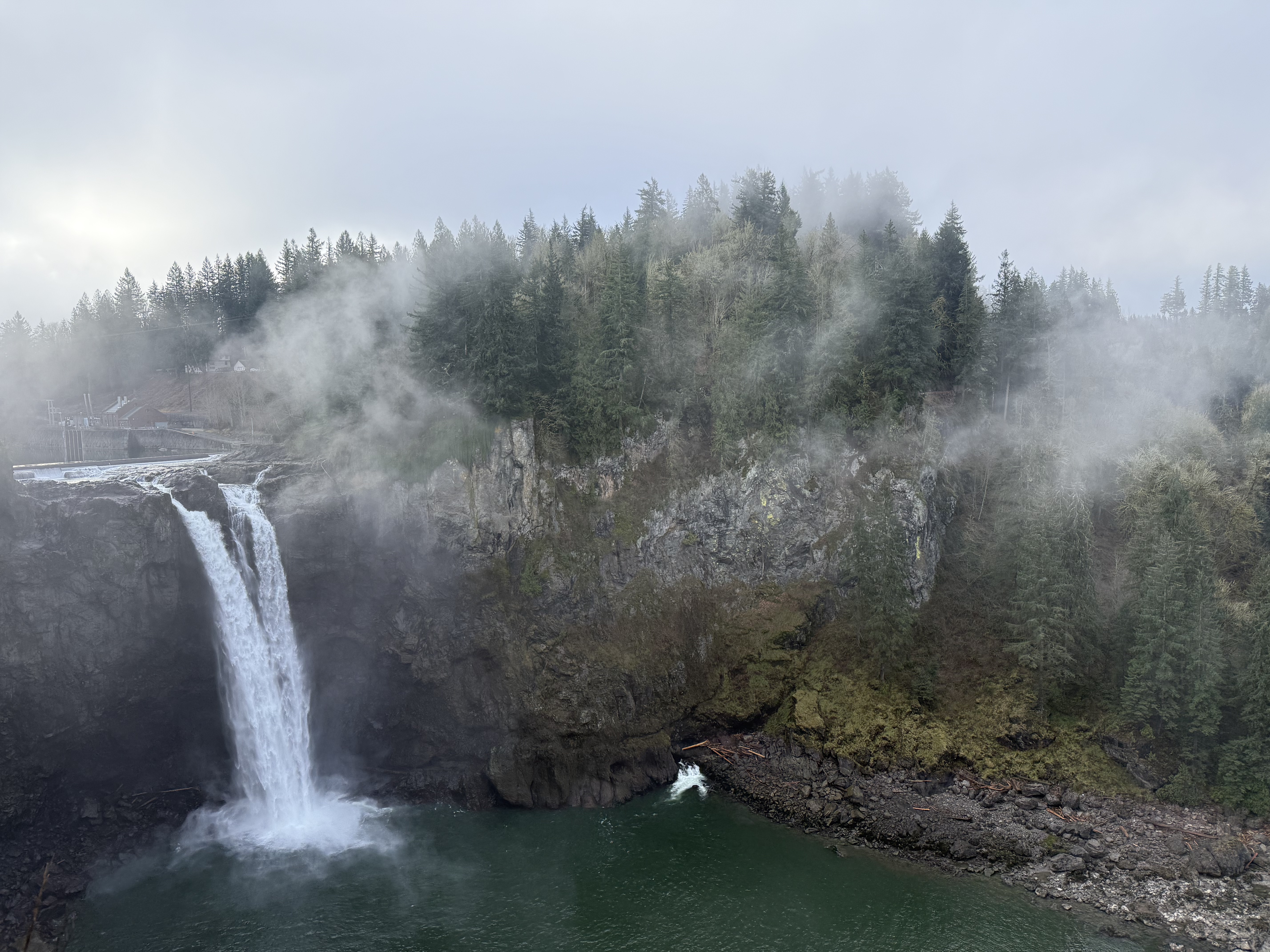
Figure 2. The 270 foot drop over Snoqualmie falls encouraged a private consortium to construct the world’s first subterranean hydroelectric power plant. The turbine outflow is visible at the bottom-center of this image. Note the massive wall of volcanics in the center of the photo. The exact origin of the falls is unknown because there are no major faults in the area, although the entire region is cross-cut by faults. The default narrative is a combination of glacial scour and natural variability in the rock composition and thus strength. For example, Niagara Falls was also formed during the last ice age along a natural escarpment, but the rocks comprise hard dolomite over soft shale; this combination led to undercutting and continuous upstream erosion at ~1 foot/year. All of the rocks at Snoqualmie falls are andesitic; however, note that the cliff ends to the right of the photo and a slope emerges. This could be a clue…
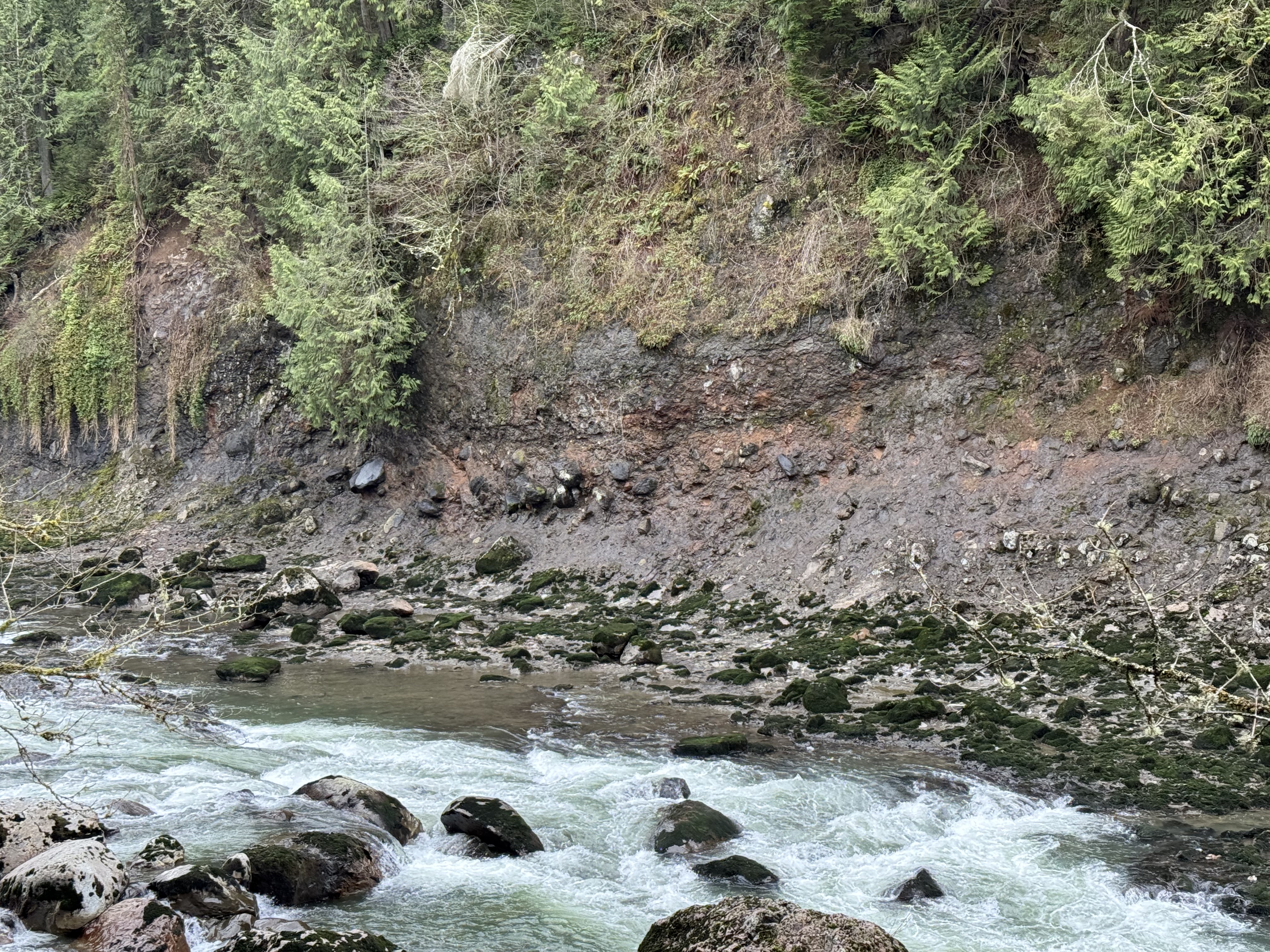
Figure 3. The riverbank several hundred yards downstream from the falls reveals a rock unit comprising large boulders in a matrix that erodes to form sand and mud.
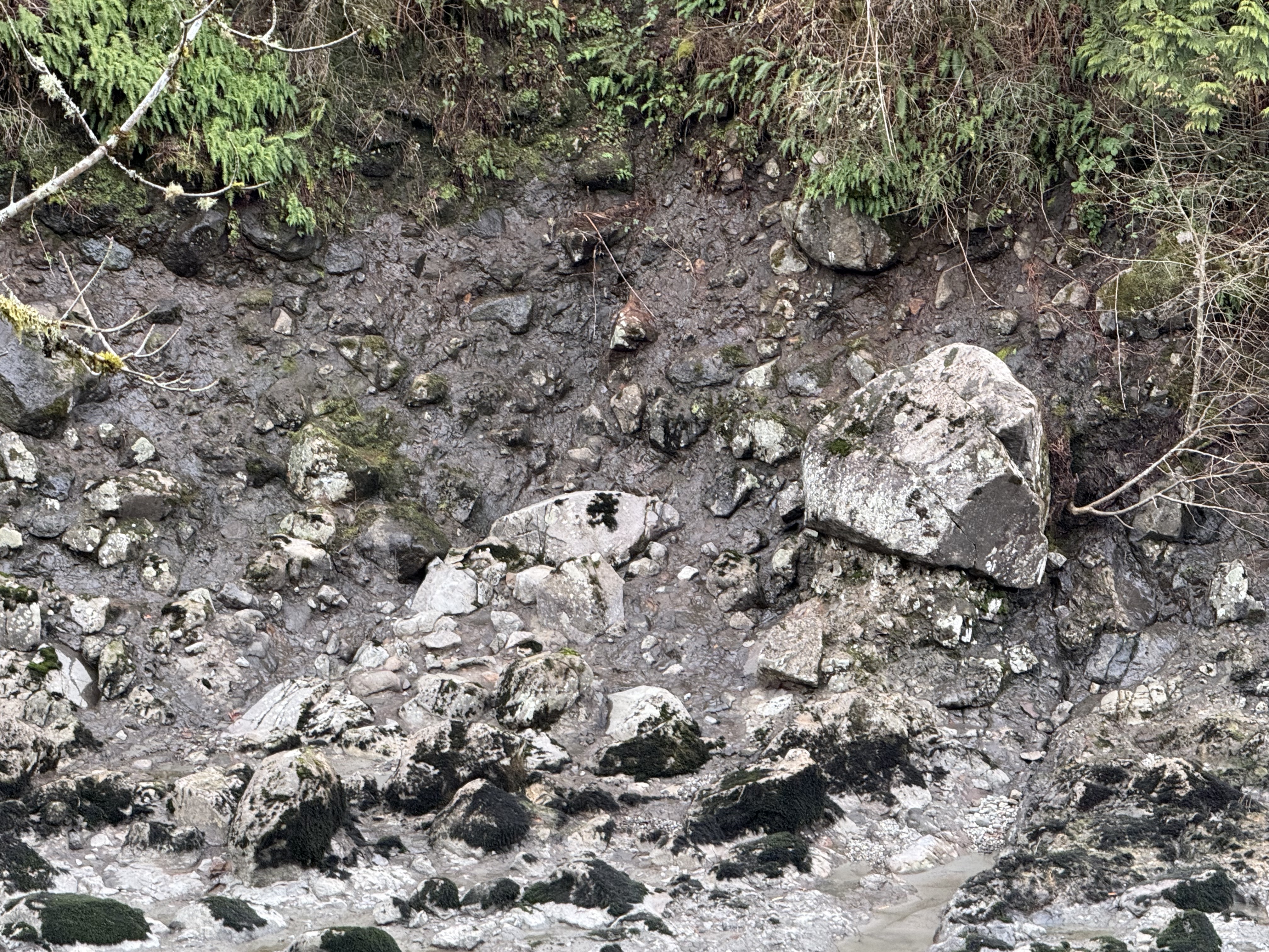
Figure 4. A close-up of the downstream bank reveals boulders several feet in diameter protruding from the cliff face. As the softer matrix material erodes, these blocks fall into the river. These are volcanic bombs–partially molten lava that solidifies in flight before landing far from the vent; volcanic bombs up to 20 feet in diameter have been ejected 2000 feet from the vent in volcanoes in Japan. Because they are soft, these ejecta become smooth during their flight and are sometimes flattened when they land. Consequently they can look like rounded boulders and cause confusion when found in a river. The giveaway is the matrix in which they are embedded. However, the story is more complicated than that…
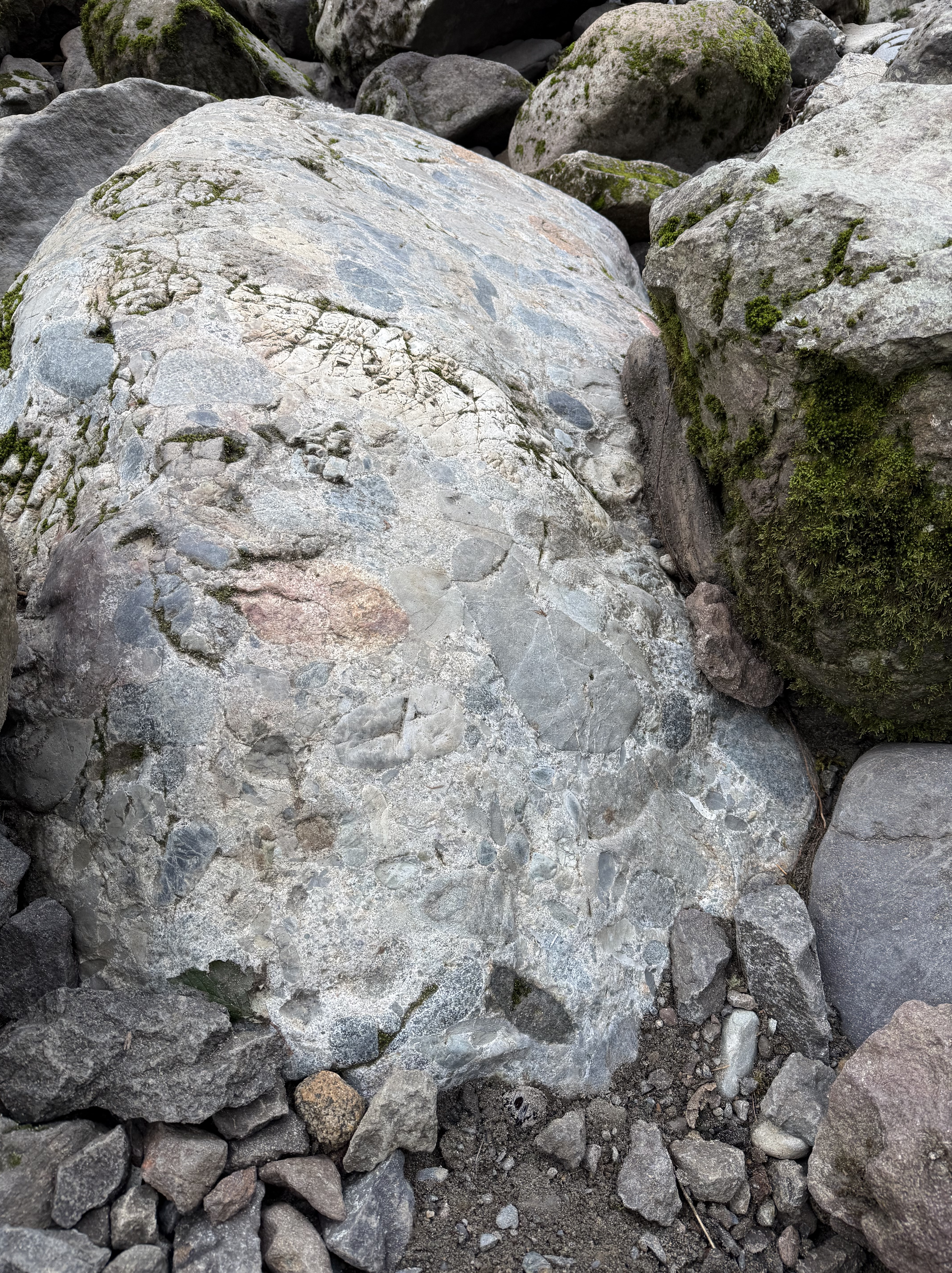
Figure 5. A boulder of volcaniclastic rock exposed in the river channel, rounded by collisions with other rocks. This sample is six-feet long. Note the mixture of tephra of different sizes and shapes. Each fragment was semi-molten when it was ejected from the vent; of course, it landed in ash rather than on hard ground. However…this sample comprises a matrix that is solid, not crumbly like the cliff base seen in Fig. 3; the only explanation I can think of is that the matrix varied substantially over time and space. In other words, this block represents an eruption of extremely hot ash, which formed a welded tuff (aka ignimbrite), encasing the tephra in stone immediately after eruption. The friable matrix in Fig. 4 wasn’t as hot; it is even possible (albeit unlikely) that this block was itself ejected from a younger eruption and became a volcanic bomb. I’m not putting any money on that; my point is that volcanic eruptions are very dynamic, and the rocks we see today represent millions of years of magma chamber depressurization.
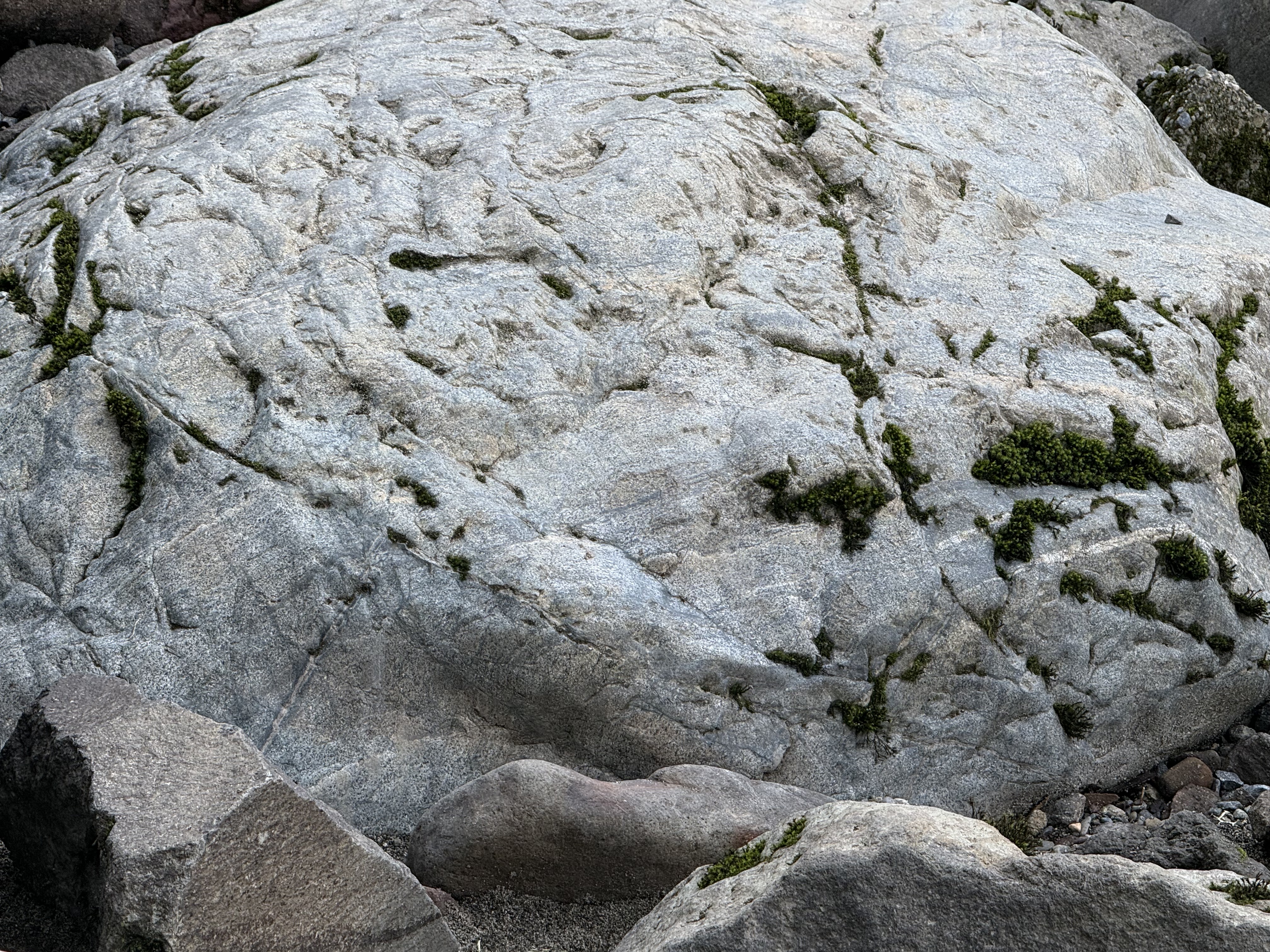
Figure 6. This eight-foot boulder contains fine layering in its lower half. This suggests that the tephra landed in a layer of ash that was so hot it became a welded tuff, even as eruptions continued intermittently. This block is NOT a volcanic bomb (despite my speculation in Fig. 5); it is a sample of the volcanic debris erupted from a vent (including volcanic bombs), which was subsequently eroded from somewhere within the local area, representing an eruption so hot it created an ignimbrite. This sample (as well as Fig. 5) thus reflects eruption and initial deposition, followed by erosion in a stream–giving them a rounded appearance similar to that of the tephra they contain; thus the term volcaniclastics.
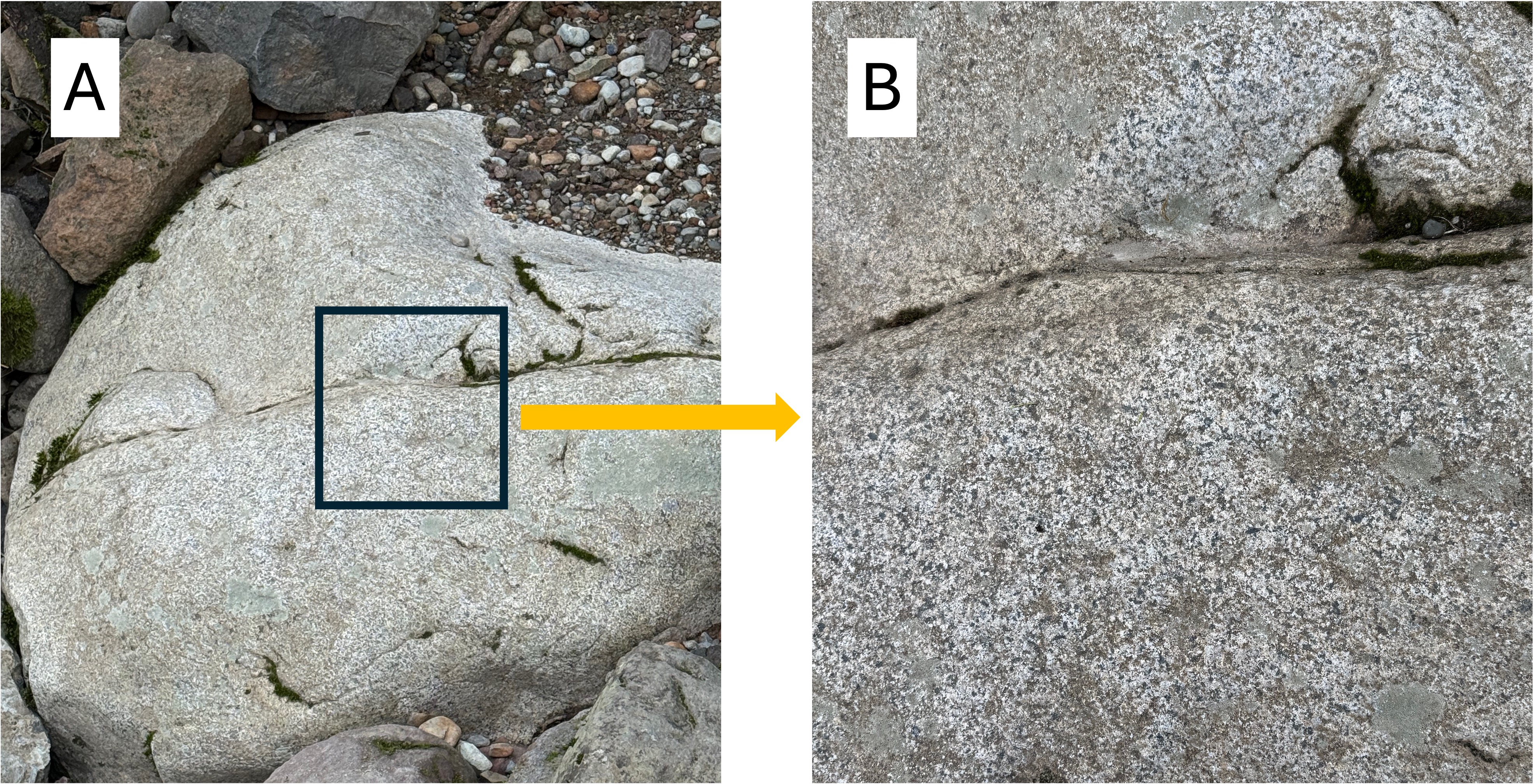
Figure 7. This is where this field trip got interesting. (A) This rounded boulder (4 feet across) doesn’t look like the volcanic rocks in Figs. 5 and 6. It contains no tephra or lamination. What’s going on? (B) A close-up photo reveals this to be an intrusive rock; individual mineral grains are visible, giving it a stippled appearance. It isn’t as coarse-grained as a classic granite with large crystals visible to the unaided eye; however, it isn’t extrusive either (microscopic grain size). This rock formed within a shallow magma chamber (possibly a dike or sill) in which the molten magma cooled faster than a deeply buried granite, but slower than an extrusive rock. This is common within volcanic terrains in which fresh magma is often injected into pre-existing layers of extrusive rocks. This sample is relatively fresh (i.e., no biological surface coverings) and thus its composition can be guesstimated: the whitish areas are feldspar (albite and plagioclase) that contains sodium and calcium, but not potassium; they comprise approximately half of the minerals; the darker grains are (probably) hornblende and biotite; a suggestion of gray implies some quartz. The relatively low quartz content suggests this is diorite. Diorite is the intrusive equivalent of andesite; it follows that the thickness of volcanic rocks visible in Fig. 2 is andesite, which is common in subduction zones. The bottom line is that this sample is NEITHER a volcanic bomb nor a block of the tephritic, extrusive rock seen in Figs. 3 and 4. It was probably emplaced within layers of older volcanics and later eroded, eventually falling into the river, where it was rounded by collisions with other boulders.
SUMMARY.
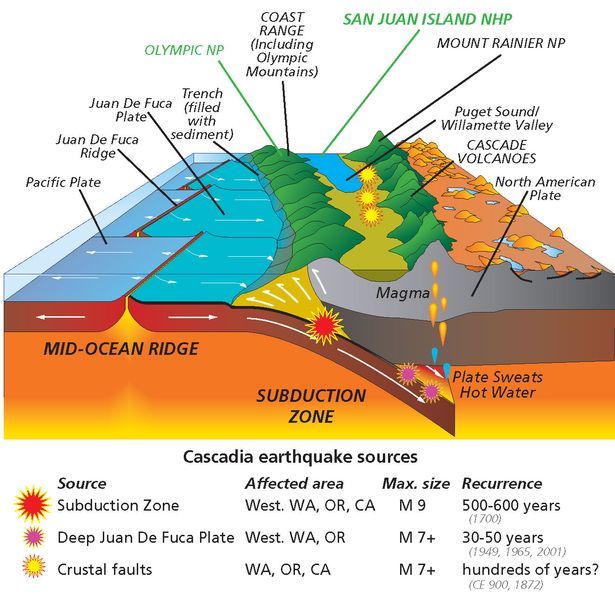
Figure 8. Snoqualmie falls is located at the northern end (top) of this schematic, within the second belt of mountains (green). The history of subduction along the Pacific Northwest (PNW) is uncertain because of intermittent subduction and crustal thickening. When Pangea split along what is now the mid-Atlantic ridge system about 200 my ago, the North American plate began a complex history of either riding over the Juan de Fuca oceanic plate or colliding with various islands and micro-continents that were in the way. By these disparate accretionary mechanisms, the west coast of N. America propagated westward hundreds of miles, at least from Montana. Jumping ahead to 50 my ago, a new round of subduction began, characterized by multiple vents, fractures, and volcanoes; these produced the older rocks of the Cascades. The Columbia plateau basalts were erupted about 15 my ago–Act II in this ongoing geological opera; the third act (using a simple theatrical model) was the appearance of multiple volcanoes fed by localized magmatic chambers in the last million years. This geological opera is complicated by at least two distinct events: (1) the San Andreas transform fault and associated strike-slip faults from Mexico to Canada, which together transport crustal blocks to the NW (i.e. Alaska); and (2) the anomalous mantle plume associated with the Yellowstone caldera.
Unlike the ancestral Appalachian mountains, whose geological history must be inferred from fragmentary and ambiguous data, the PNW geo-opera is being performed before our eyes.
Think about it–Mt St Helens wasn’t an outlier…anything can happen in the PNW…
Recent Comments
| Pinnacle Peak Park:… on Cool Pleistocene Basalts | |
| Pinnacle Peak Park:… on Snoqualmie Falls: Eocene Volca… | |
| Anonymous on A Review of “Until I Fin… | |
| Anonymous on Repaso de “Yo no soy tu… | |
| Anonymous on Review of “Burn-In… |

Trackbacks / Pingbacks