
Slipping and Sliding: Holocene Landslides in Central Virginia
Introduction.
This post is a summary of a field trip I took during the Geological Society of America’s Southeastern Section meeting in Harrisonburg, Virginia: Ancient and Modern Landslides of the Eastern Blue Ridge of Virginia. I was joined by more than twenty geologists on this ten-hour excursion, which was led by two geologists from the Virginia Department of Energy. Thus, I’ll be adding my photographs and comments to the narrative supplied by our expert guides, as well as aircraft-flown LIDAR (Laser Imaging Detection and Ranging) data with one-meter resolution and maps compiled by the VADoE Geology and Mineral Resources division.
Debris flows have been identified in many places and certainly occurred throughout geological time, often associated with alluvial fans or volcanic eruptions. This post focuses on those which pose some hazard to the residents of Virginia and is not an exhaustive catalogue of all such features.
We looked at landslide deposits ranging in age from about 10000 years ago ( Holocene) to a debris flow created by a severe thunderstorm in 1995. Such deposits can be classified as modern, relict or ancient. As I understand these terms, modern can be attributed to a specific event. In geomorphology, a relict landform is a landform formed by either erosive or constructive surficial processes that are no longer active as they were in the past (Wikipedia). An ancient landform is from the geological past and has been extensively modified by surface processes, as well as burial and metamorphosis for very old rocks.
Any errors in my report are solely due to my misunderstanding what was presented on a topic I am unfamiliar with and not the leaders of the field trip.
Observations.

Figure 1. (A) The study area is located along the first ridge of the Valley and Ridge province of the Appalachian Mountains. Blue colors indicate higher elevations, including the Blue Ridge with peaks of about 400 m. The Blue Ridge is not strictly part of the Valley and Ridge; it is the result of a series of thrust faults which placed Precambrian metamorphic rocks over younger Paleozoic strata. (B) The field area (black ellipse) encloses a crenulated landscape comprising short canyons with steep slopes and rolling valleys. We visited the numbered stops in sequence.
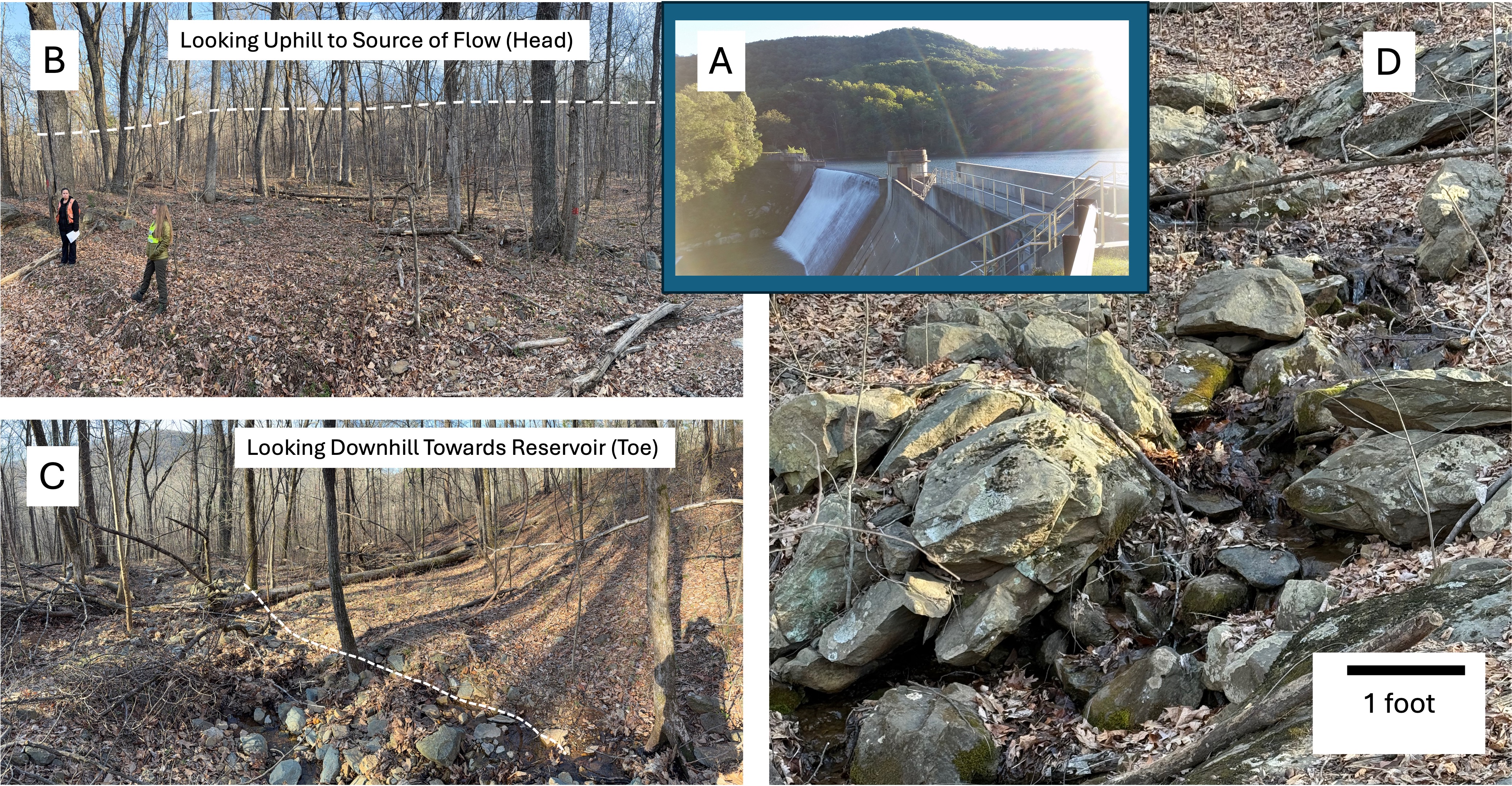
Figure 2. (A) Our first stop was at Sugar Hollow Reservoir. An intense thunderstorm dropped torrential rain on the area in June, 1995, causing a debris flow that decreased the reservoir’s volume by 15%. (B) Looking uphill we see an undulating surface littered with angular boulders from the top of the hill (dashed line). (C) Streams have started eroding into the debris flow, revealing a jumble of boulders beneath the surface, as seen in plate D. Recent mass flows like this are recognized by an irregular surface and angular boulders that didn’t originate from nearby slopes.

Figure 3. (A) Stop two (see Fig. 1B for location) took us to a relict debris flow easily identified in this high-resolution LIDAR image (courtesy of VA Dept. of Energy). Note the hummocky surface which originates at the top of the ridge. (B) The slope is very steep here and there were no trails to the summit. The Moorman River is at the bottom of the slope. (C) Photo taken at the location of the triangle in (A). The image shows a cutout from the slope, indicated by dashed lines; the long dashes locate the top of the scarp and the short dashes the approximate location of the lip. Compare this to the LIDAR image in (A), which shows a depression with a slight lip. There was a dramatic change in surface morphology along the slide, which is delineated by downslope ridges on either side.
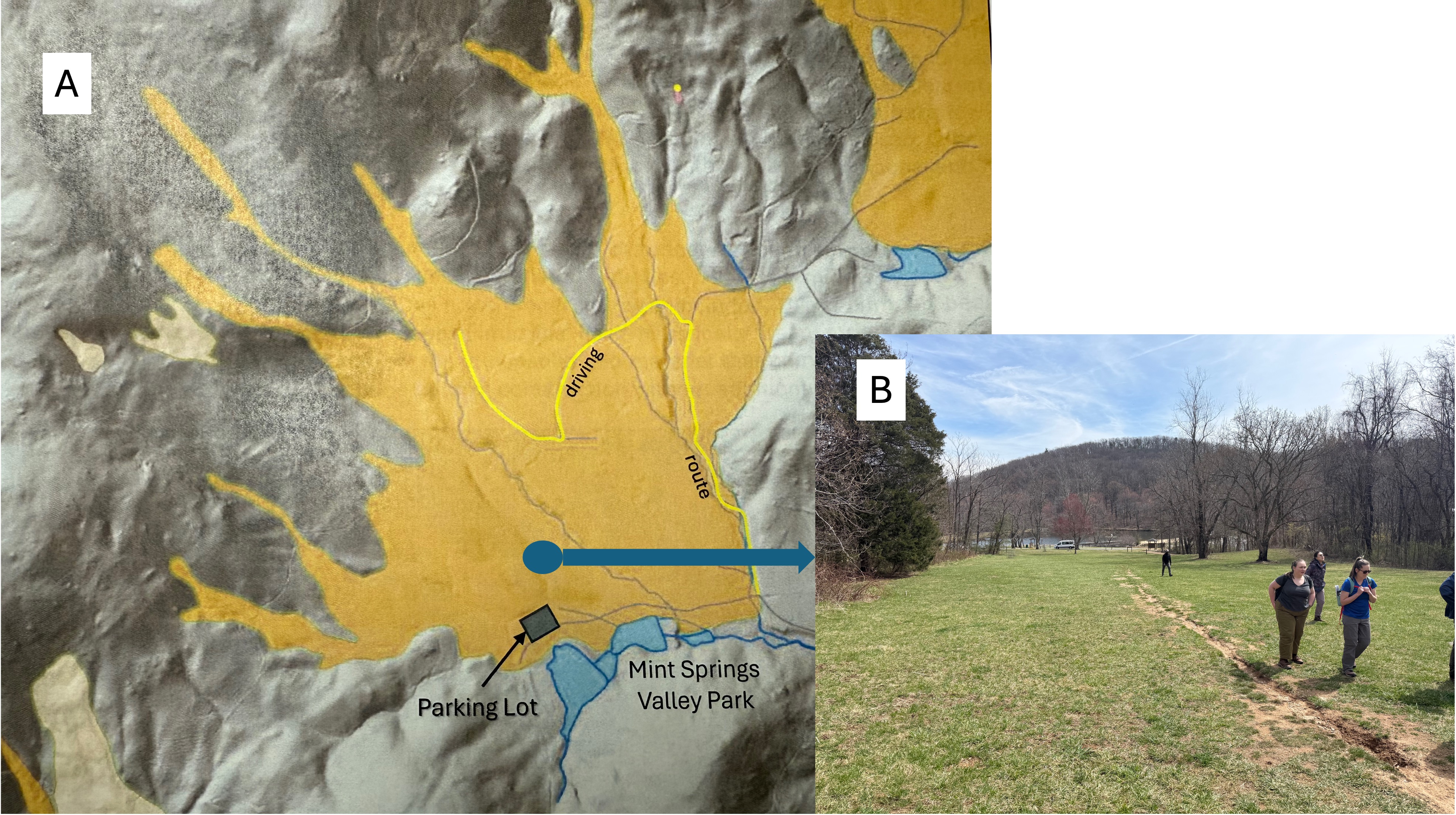
Figure 4. (A) Map of a debris flow (aka alluvial fan) at Mint Springs Valley Park, stop three in Fig. 1B (map courtesy of VA Dept. of Energy), showing how it was focused on the small lake at the park. Further up the valley, large boulders became apparent, but the landscape had been massively altered during construction of homes. (B) At the park, the slide appears as a smooth (graded) surface devoid of large boulders.

Figure 5. Ancient landslide deposit at Stoney Creek Park (stop 4 in Fig. 1B). (A) A stream-cut cliff revealed weathered Precambrian granulite directly overlain by a unit composed of angular-to-weathered boulders supported by a fine-grained matrix. The original bedding of the granulite, which originated as a sedimentary rock (probably sandstone or arkose) is labeled. The original sediments were deeply buried to reach such a high metamorphic grade, before being uplifted and eroded to create a surface on which the debris flow was deposited, probably in the precursor to the modern stream. (B) Detail showing the characteristic matrix-supported structure of the debris flow. This flow is interpreted as older, due in part to the extensive weathering of the clasts it contains. There was a lot of mud moving with these boulders.
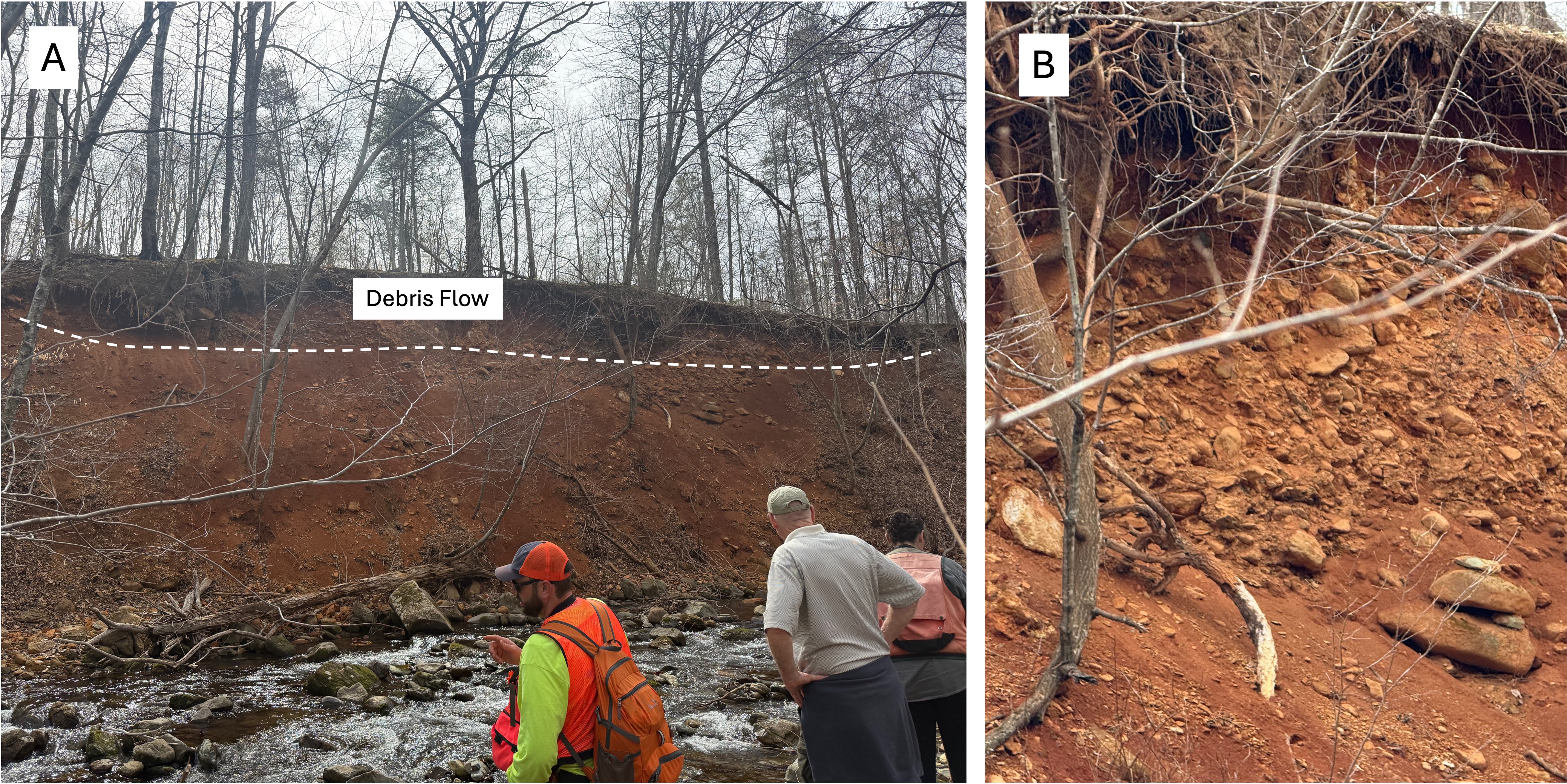
Figure 6. Ancient landslide deposit at Stoney Creek Park. (A) A debris flow is exposed as a planar surface on top of alluvium. Other flows are suggested by the exposure of boulders lower within the section, but it was difficult to be sure because of collapse of the upper surface. (B) This detailed image of the surface deposit reveals a higher concentration of boulders than in Fig. 5. They are also more rounded. This suggests fluvial reworking, which would have removed much of the fine matrix seen in Fig. 5. This flow, and others lower in the section, are considered to be younger in age, although radiometric dating is not available. Furthermore, the geologic map from Rock D (not shown) indicates several faults aligned with Stoney Creek, suggesting that uplift contributed to mass wasting of highlands to the west.

Figure 7. Stop five, Edgewood Farm (see Fig. 1B for location). (A) Geologic map from Rock D, annotated to show the source of material for a slide that was concentrated on a farm (blue circle) by a narrow gorge. (B) view looking WSW towards Mars Knob, showing the toe of the debris flow that resulted from heavy rain during Hurricane Camille in 1969. (C) Large boulder at the entrance to the canyon, marking the extent of transport of such debris. (D) Hummocky and boulder-littered surface within the arroyo, similar in appearance to stop one (Fig. 2).
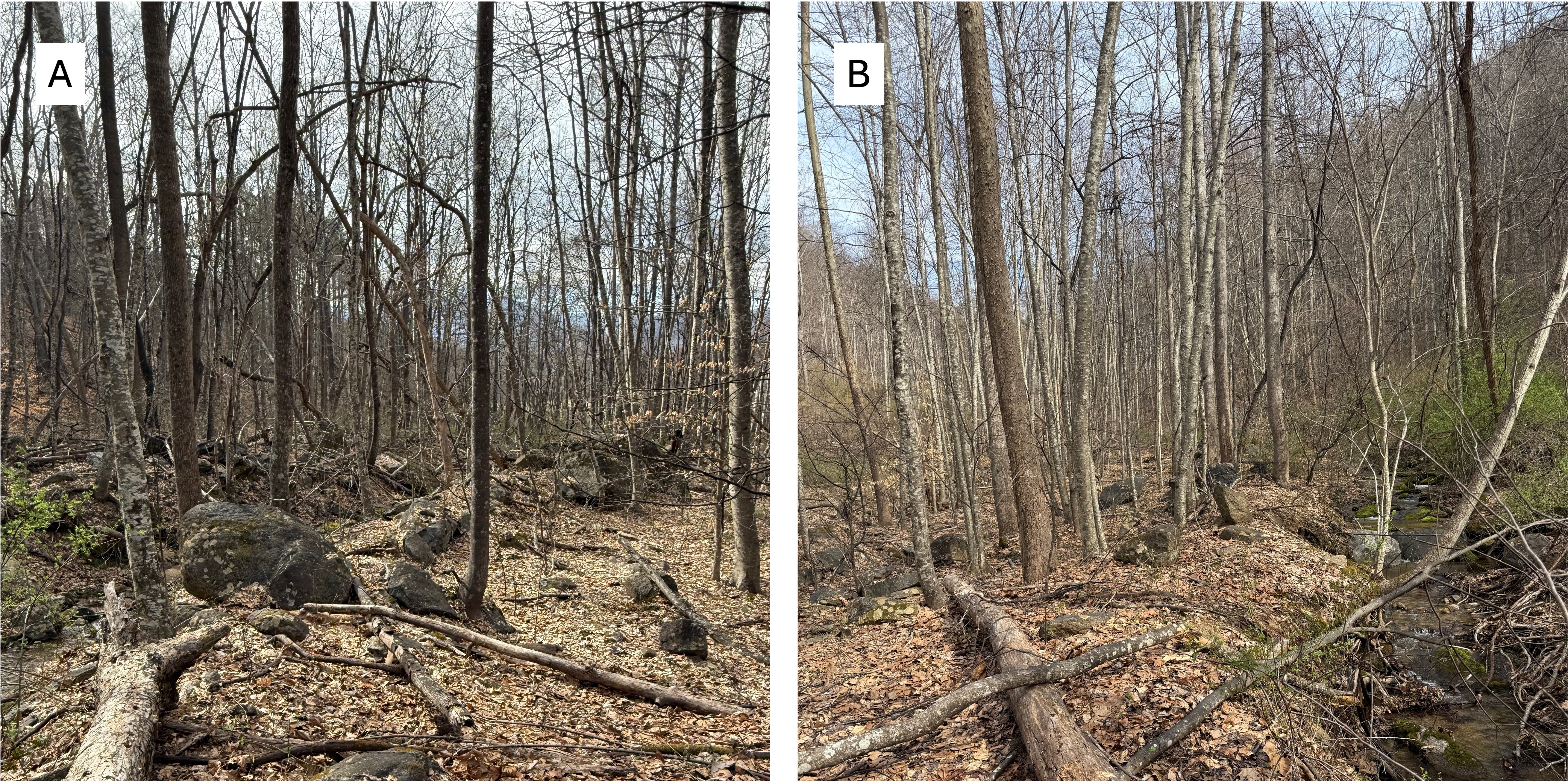
Figure 8. Images further upstream at stop five. (A) The north side of the valley is blocked by debris, including large boulders (>4 feet). (B) The south side seems to be less congested, and the stream has eroded a new channel through less-resistant material although the bed comprised smaller boulders (<2 feet). Such a large volume of material originated from a large source area (Fig. 7A) that was saturated by heavy rain, transporting a massive amount of rock debris with a relatively small amount of mud.
Summary.
I have only briefly summarized all the information supplied during the field trip. Nevertheless, these observations reinforce my previous opinion that surface erosion is dominated by episodic events. From thin layers of sand on alluvial fans, flood deposits along large rivers like the Mississippi, and storm beds on the continental shelf, to pyroclastic flows and fluvial/alluvial debris flows like these, Mother Nature doesn’t do anything slow and easy. It’s more like wait and wait … then all hell breaks loose.
At least that’s what I think …
Acknowledgment.

Figure 9. This field trip was led by Wendy Kelly (left) and Anne Witt (right) of the Virginia Department of Energy’s Division of Geology and Mineral Resources. Their expertise made this a very enlightening and geologically uplifting experience. I will certainly be on the lookout for evidence of debris flows as I continue my geological adventure.

Recent Comments