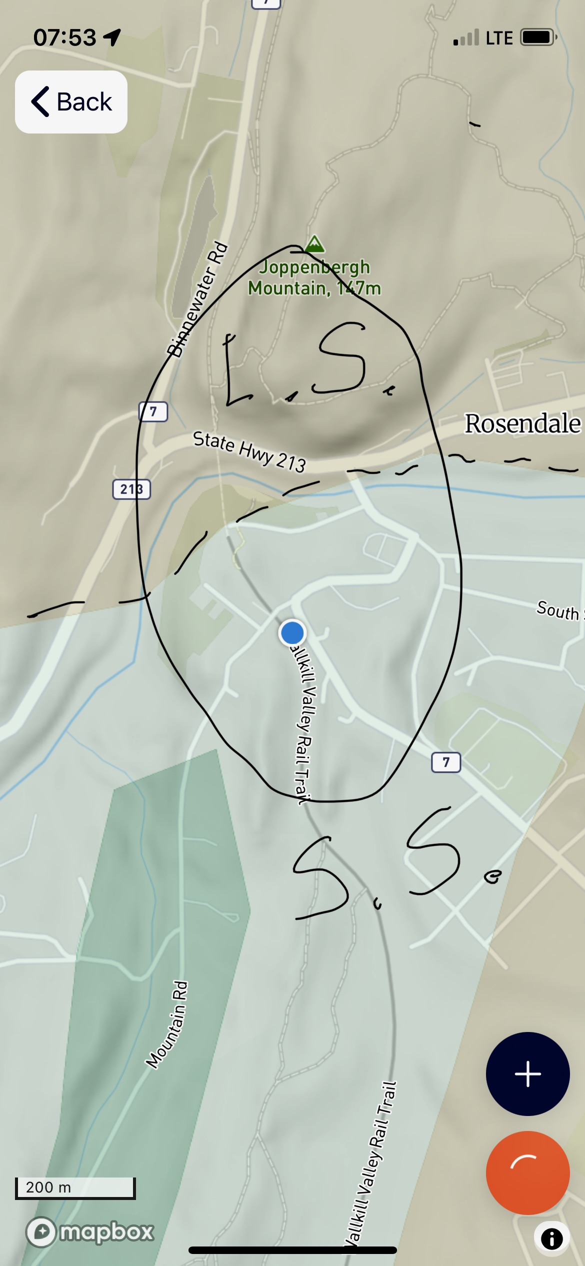
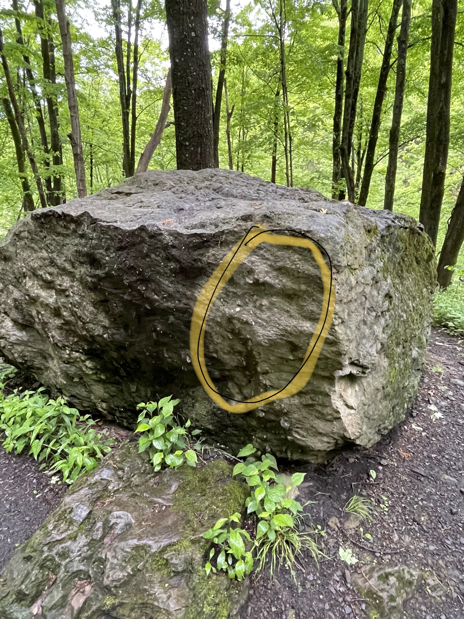
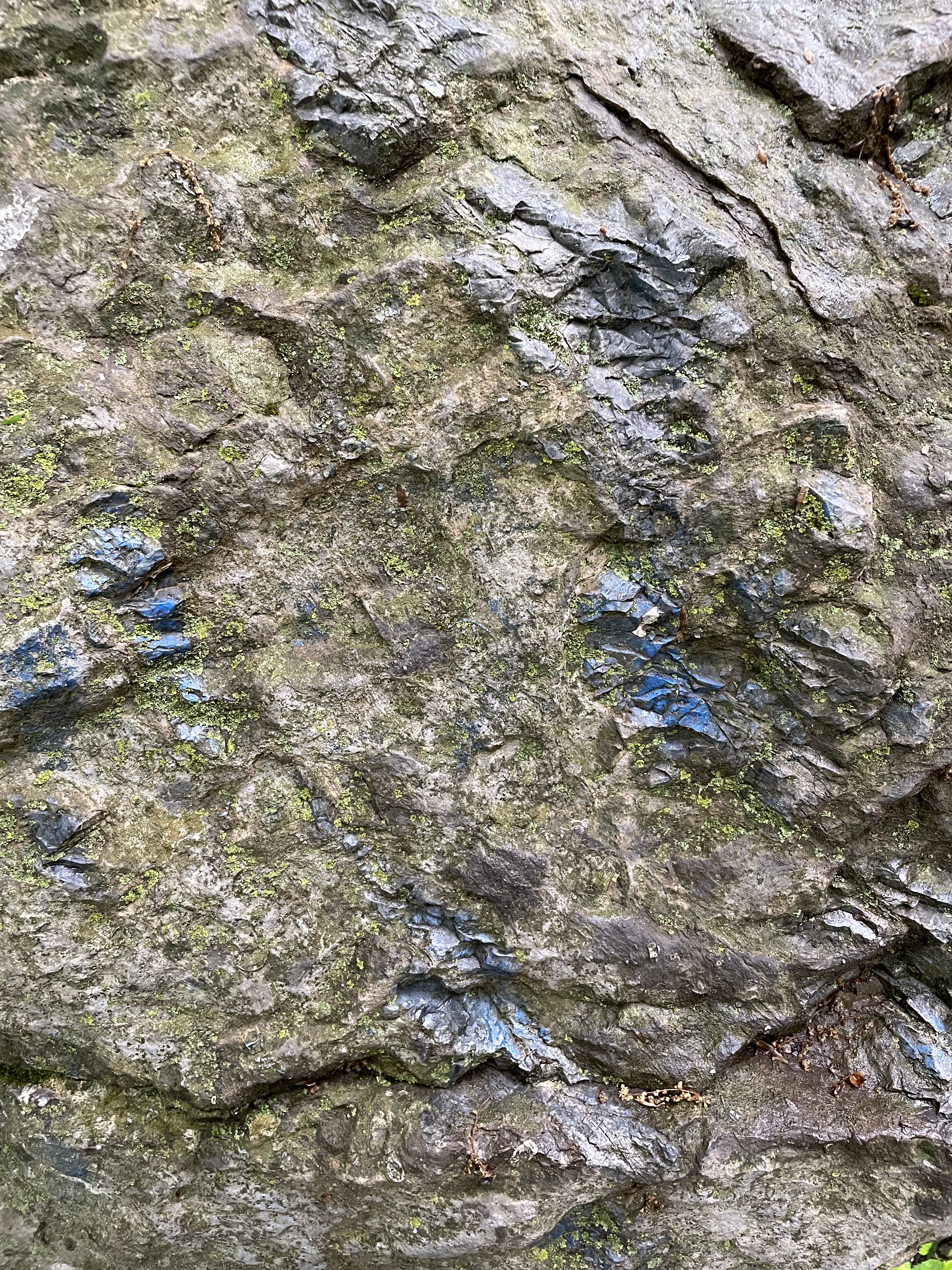
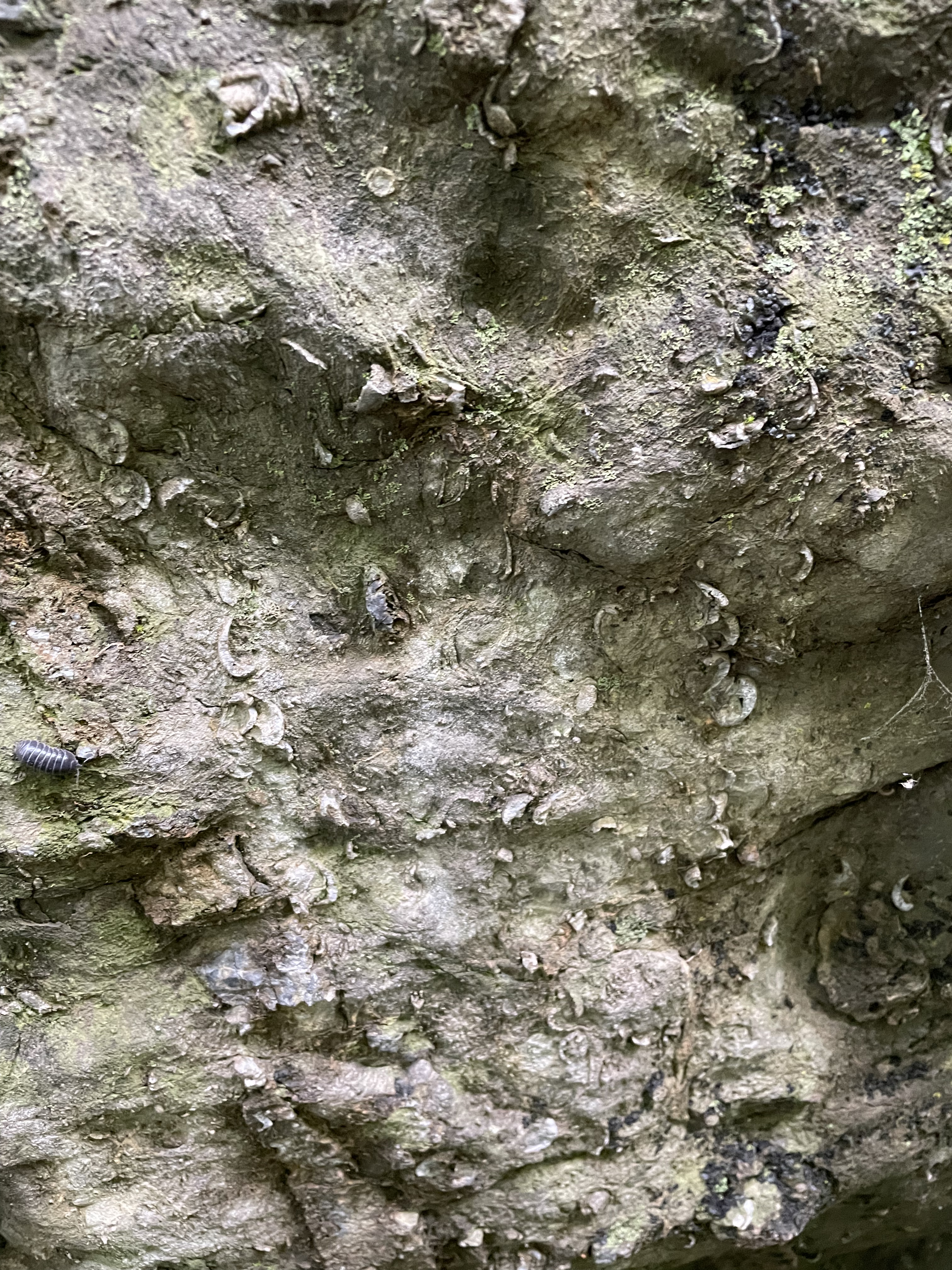
Figure1. View of Rondout Creek from the Trestle trail in NY state. Several tributaries of the Hudson River are constrained by ridges like those seen in this photo. Most of the exposed rocks are Bloomsburg Formation (Silurian, , 427-419 Ma), consisting of shale, sandstone, quartzite, conglomerate, all metamorphosed to some extent. They were deposited near a source of coarse sediment but include nearshore marine and deep water environments. Figure 2. Billboard of the Wallkill Valley, named after the primary Hudson tributary west of the river. Figure 3. Geologic map of study area. The location of Fig 1 is over the blue line (Rondout Creek) just below the label for State Hwy 213. The dash line is the contact between Bloomsburg rocks (427-419 Ma; gray area labeled S.S.) and undifferentiated Ordovician to Devonian (443 to 393 Ma) limestones, sandstone, shale, conglomerate (labeled L.S.). The specific dates of the Bloomsburg formation are probably due to radiometric dates from volcanic layers (probably ash) whereas the much broader interval of the other assemblage suggests that it was dated primarily through biostratigraphic methods, which are not precise. Also, the relationship suggests that the environments represented by these assemblages were spatially variable; i.e., Bloomsburg was one delta sequence among many that moved around during the 50 Ma span of deposition represented here. Figure 4. Blockoflimestone located along the trail within the L.S. Area indicated in Fig. 3. The block is about eight feet across. The circled area contains several larger objects that will be examined in Fig. 4; the ridge seen in the topography of Fig. 3 couldn’t be examined, but many caves were visible at its base, suggesting chemical weathering of limestone. As a further note, the trail we followed in later images was allied Kiln trail; a kiln is a place where limestone is quarried and heated to produce lime, used as fertilizer and an ingredient for cement. It is reasonable to assume that the kiln was somewhere on the north side of Rondout Creek.Figure 5. Close-up of block in Fig. 4, showing blue and green calcite (probably malachite) areas within a gray background. The coloration comes from high, local concentrations of Copper, Carbon, and Manganese.Figure6. Close-up of fossil assemblage from Fig. 4; I’m not a paleontologist but I recognize bivalves (curved) and echinoids (circular and columnar), two common groups found in Paleozoic nearshore marine environments. The living, segmented insect to the upper left is similar to a trilobite, which was probably also present on the original sea floor. This would have been the Paleozoic equivalent to a coral reef (no corals yet). Figure7. Exposure of Bloomsburg Formation conglomerates at the location of the blue dot in Fig. 3. The yellow lines indicate the bedding plane, which was the original river/sea bottom when the sediments were deposited. They dip about 30 degrees to the SE, very similar to rocks we found in Northern Virginia. Figure8. Close-up of undifferentiated rocks (labeled L.S. in Fig. 3). This photo shows that nearshore sediments are not uniform because of changes in river mouths, erosion of coastal uplands, sea level changes, etc; the laminae seen in the center of this image suggest deposition of fine particles in quiet water. Such rhythmic layering is often created by tidal flows. This exposure was only a few thousand years younger (tens of feet higher in the section) than limestone with caves; of course, this could be limestone, but it wasn’t part of a reef.Figure9. Close-up of Bloomsburg Formation conglomerate, showing rounded pebbles in a sandy matrix. This sample doesn’t show layering but in other locations, the pebbles were aligned in layers suggesting episodic flow events. These sandy sediments are reddish, which suggests they were deposited in fresh water (red indicates oxidized iron when deposited); marine sediments tend to be green or gray (reduced iron in ocean water). Precise dating of these events is impossible, but we can say that, within a few hundred thousand years, quiet water (e.g. Figs. 6 and 8) was replaced by high flow events in rivers transporting pebbles. Figure10. Image of quartzite/conglomerate exposed at the top of a ridge, showing striations formed by glaciers advancing from the NW, dragging stones with them and gouging these scratches. The arrow indicates the direction of movement. The white areas indicate where quartz has been ground into powder by the force of stones buried beneath thousands of feet of ice. Gouges can’t be dated but this was probably during the last million years, when glaciers reached their maximum thickness in this area.Figure11. Blocks of Bloomsburg Formation sandstone that collapsed recently, carrying ferns with them. This area was littered with such blocks carrying post-glaciation soil profiles and plants with them. Figure12. View looking east from a ridge near the bottom of Fig. 3 (where the trail makes a loop). This is where Fig. 10 was taken. These rocks have been exposed to the elements since this area was covered by ice.
SUMMARY. This part of central New York was very different about 400 million years ago. It wasn’t a deep ocean, but instead consisted of a spectrum of nearshore environments, from reefs to lagoons, deltas, and finally conglomerates containing rounded pebbles. The coarser sedimentation occurred later within this time interval, suggesting that mountains were rising to the east, shedding coarser sediments further west with every passing millennium.
This was the final collision of proto-North America with Eurasia in what has been called the Acadian Orogeny. We saw only a small fraction of this regional event during our walk today, but the rocks we encountered encompassed the entire event. Shallow seas filled with reefs and shallow marine environments were replaced by streams carrying pebbles less than fifty miles from their source in rapidly rising highlands.


Trackbacks / Pingbacks